
The weekend just gone (Saturday 10th & Sunday 11th March 2018) saw the special activation weekend for the 5th anniversary of the VK5 National & Conservation Parks Award. The Award which commenced in April, 2013, promotes portable activity from South Australia’s National & Conservation Parks. And every year in March or April a special activation weekend is held to celebrate the anniversary of the award.
On Friday 9th March 2018, my wife Marija VK5FMAZ and I headed down to the South East region of South Australia to activate some parks, and spend 3 nights in the beautiful seaside town of Robe. It is about a 300 km drive from our home in the Adelaide Hills to Robe. We decided to take the Princes Highway from Tailem Bend down to Meningie, and then onwards to Robe following the coastline and the Coorong National Park.

Above:- Our journey from the Adelaide Hills to Robe in the South East of South Australia. Map courtesy of plotaroute.com.
Between Tailem Bend and Meningie we had a tune across the band and found Rob VK4AAC/2 calling CQ from the Bungonia National Park VKFF-1163. Rob had a good 5/7 signal and gave us a 5/5 signal report from the mobile. Soon after we worked Tony VK3XV/5 who was activating the Desert Camp Conservation Reserve VKFF-1705. Tony had come over with his wife Sheryl from Victoria to take part in the 5th year anniversary event. Many thanks Tony and Sheryl.
Our first stop of the morning was at Salt Creek, a small settlement about 61 km south east of Meningie. We stopped briefly to have a look at the Oil rig monument. In 1892, a group of entrepreneurs, who believed there was oil located in the Coorong, drilled Australia’s first oil well. They were unsuccessful, as it was later discovered that the ‘oil’ was in fact a flammable, compacted vegetable substance known as ‘coorongite’.

Above:- Marija at the Oil rig monument at Salt Creek.
Marija and I decided to venture off the Princes Highway and take the Coorong Loop Road through the Coorong National Park 5NP-005 & VKFF-0115. The loop road commences at Salt Creek and travels about 13 km through the park before joining up again with the Princes Highway. Whilst on the Loop Road we stopped briefly to make a Park to Park contact with Tony VK3XV/5 in the Desert Camp Conservation Reserve.

Above:- Our view of the Coorong during our contact with Tony VK3XV.
Our next stop was just a little further down the road at Chinaman’s Well which is located in the Coorong National Park. The area is so named due to a freshwater well which was constructed in the 1850’s.
During the 1850’s thousands of Chinese people landed in South Australia with the prospect of making their wealth on the Victorian goldfields at Ballarat, Bendigo, Castlemaine, and Beechworth. Those that did arrive in South Australia walked the 800 km to the goldfields across wetlands, desert, hills and plains.
Why walk from South Australia? Why not land in the Port of Melbourne? In an attempt to limit the number of Chinese on the Victorian goldfields, a law was passed which stated that any Chinese person entering the Colony of Victoria would pay a ten pound tax and one pound protection fee, for the right to mine and live in the colony. As a result ships arriving from overseas would drop the Chinese arrivals off in Sydney or Adelaide.

Above:- A Chinese emigrant on the journey to the Victorian Goldfields.. Image courtesy of http://www.kidcyber.com.au/gold-rush-in-australia/
Between 1857 and 1863 it is estimated that over 17,000 Chinese walked from South Australia to the Victorian goldfields. In 1859, at the peak of the Victorian gold rush, the Chinese population in Victoria reached 46,000. The Chinese made up about 1/5th of the total male population in the mining towns in Victoria in this period.
You can do a 45 minutes walk here and view the sandstone and limestone quarries and the well itself. Although there are interpretive signs, sadly the walk is not well signposted. But it is well worth doing and gives you a very good impression of the oppressive journey that the Chinese undertook in the hope of finding gold.
Marija and I continued south on the Princes Highway towards Kingston SE. Along the way we logged Tony VK3XV/5 who was now in the Padthaway Conservation Park 5CP-169 & VKFF-0924.
We stopped briefly at the town of Kingston SE. The town was named after Sir George Strickland Kingston, a South Australian politician, surveyor and architect. The town was established in 1861 and was originally known as Kingston. The extension on its name is to distinguish Kingston in the South East (of South Australia) from another ‘Kingston’ in the state which is now officially named “Kingston On Murray” was added in July 1940.
One of the famous attractions in the town is the Big Lobster, known as ‘Larry’ by the people of Kingston. ‘Larry’ is a sculpture of a spiny lobster, and stands around 17 metres tall. It can be located outside of a former visitor centre and restaurant, which sadly is no longer in operation.

‘Larry’ the Lobster
Another attraction in the town is the Cape Jaffa Lighthouse, which is a decommissioned lighthouse formerly located on Margaret Brock Reef near Cape Jaffa on the south east coast of South Australia. The tower has been located in the town of Kingston SE since 1976.


We stopped off at a local cafe and picked up some lunch and headed down to the foreshore and enjoyed lunch whilst watching the ocean.
It was around 2.30 in the afternoon and we were quite close to Robe, so we decided to do a quick park activation at the Butcher Gap Conservation Park 5CP-027 & VKFF-0793. This was to be a new park for both Marija and I, for both the VK5 Parks Award and the World Wide Flora Fauna (WWFF) program.
The park is located about 6 km south of the town of Kingston and about 294 km (by road) south east of Adelaide.

Above:- Map showing the location of the Butcher Gap Conservation Park in the South East region of South Australia. Map courtesy of Location SA Map Viewer.
Butcher Gap Conservation Park is 180 hectares in size and was first proclaimed on 29th March 1990. It is one of the last remaining significant coastal scrubs between the Coorong and Robe. The park encompasses Salt Lake and Butcher Lake, and is separated by the Butcher Gap Drain which brings large amounts of fresh water from the farmlands, through the park and out to sea.
The park’s wetland area supports an association of dense South Australian Swamp Paperbark over marine meadow, while the remainder of the Park is a coastal scrub association. Salt Lake usually holds water between June and January.
The park attracts an array of wildlife throughout the year. Seasonal waterbirds such as swans and white-faced herons frequent the lakes, while small bush birds may be seen along the park’s scenic walking trails. During the months of spring and summer, the area is visited by Japanese snipe and other wading birds. In winter the park provides an important refuge for the endangered orange-bellied parrot.
The following birds have been recorded in the park: Superb Fairywren, Spiny-cheeked Honeyeater, Singing Honeyeater, Brown Thornbill, Silvereye, Beautiful Firetail, Latham’s Snipe, Common Bronzewing, Rufous Bristlebird, Yellow-rumped Thornbill, White-browed Babbler, Orange bellied parrot, and Red-browed Finch.

Above: Orange bellied parrot. Image courtesy of wikipedia
To get to the park we travelled along Pinks Beach Road which runs off the Southern Ports Highway. As you enter the 50 kph area of Pinks Beach you will see a small brown sign on the southern side of the road which reads ‘Butchers Gap Conservation Park’. There is a driveway here which leads to a small parking area.


We parked the vehicle and then walked about 50 metres down the wide track and set up our station which consisted of the Yaesu FT-897 and the 20/40/80m linked dipole.

Map showing our operating spot in the park. Map courtesy of Location SA Map Viewer.
Our intention was just to get 10 contacts and qualify the park for the VKFF program, so Marija and I decided to swap the mic during the activation. This meant that we could only run 10 watts PEP due to Marija’s Foundation licence conditions.
Prior to calling CQ we tuned across the 40m band and worked Tony VK3XV/5 who was activating the Padthaway Conservation Park 5CP-169 & VKFF-0924. Padthaway was only about 96 km away by road, so due to us being close to each other, signals were well down. However due to the lack of man made noise on the band from each park, we were able to easily log each other.
We then moved down to 7.139 and started calling CQ. This was answered by Peter VK3PF, followed by Peter VK5ZPG, and then Deryck VK4FDJL. But it was really hard going, with very few takers. Peter VK3PF came back to us and kindly gave us another one of his calls VK3KAI. We were quite concerned that we weren’t going to get our 10 contacts to qualify the park for VKFF.
With 8 contacts in the log, I decided to take a few photos, and Marija kept persevering. Finally, after 23 minutes, Marija had contact number 10 in the log, a QSO with Ross VK7ALH.


Marija logged a total of 24 stations and we then swapped the mic. Marija took a break and I jumped into the ‘drivers seat’. I logged a total of 24 stations on 40m from VK1, VK2, VK3, VK4, VK5 and VK7, before deciding to try the 20m band.
I headed to 14.310 and started calling CQ, but soon had to put up with the Over the Horizon Radar. Ross VK7ALH was my first caller, who had followed me up from 40m. This was followed by Dale VK4NBX and then Ray VK4NH.
I was now just 5 short of the required 44 QSOs to qualify the park for WWFF. As I hadn’t logged many South Australian stations I decided to try the 80m band. Greg VK5GJ was first in the log there, followed by Ivan VK5HS and then Norm VK5GI. Marija also logged Greg, Ivan, and Norm. Sadly, they were our only takers on 80m.
So with just 2 QSOs needed, I headed back to 40m and called CQ again on 7.139. Ivan VK5HS had followed me back to 40m and he was my 43rd contact, followed by Mick VK3DDZ who was the magical 44th contact.

It was now around 4.30 p.m. and time to pack up, with a 40km trip ahead of us down to Robe. Marija and I had both qualified the park for the VK5 Parks Award, and VKFF. And despite hard work, I had also qualified the park for the global WWFF program.
Marija worked the following stations on 40m SSB:-
- VK3XV/5 (Padthaway Conservation Park 5CP-169 & VKFF-0924)
- VK3PF
- VK5ZPG
- VK4FDJL
- VK3KAI
- VK2HHA
- VK5FANA
- VK3SQ
- VK2EXA
- VK7ALH
- VK2RP/m
- VK2PKT
- VK2KYO
- VK3UH
- VK3MIJ
- VK7FRJG
- VK5KLV
- VK3WAR
- VK3ZD
- VK2AKB
- VK3FSPG
- VK3MPR
- VK7QP
- VK3SIM
- VK5GJ
- VK5HS
- VK5GI
I worked the following stations on 40m SSB:-
- VK3XV/5 (Padthaway Conservation Park 5CP-169 & VKFF-0924)
- VK3PF
- VK5ZPG
- VK4FDJL
- VK3KAI
- VK2HHA
- VK5FANA
- VK3SQ
- VK3SIM
- VK5KLV
- VK2EXA
- VK7ALH
- VK2PKT
- VK3FSPG
- VK3MPR
- VK2NP
- VK2BDR/m
- VK2RP/m
- VK7VZ/p
- VK7FRJG
- VK3WAR
- VK1MIC
- VK7DIK
- VK3FLCS
- VK2USH
- VK3ZVX
- VK3UH
- VK4FARR
- VK2IO
- VK3BU
- VK3VGB
- VK7LH
- VK2YK
- VK3TKK/m
- VK5HS
- VK2DDZ
I worked the following stations on 20m SSB:-
- VK7ALH
- VK4NBX
- VK4NH
- VK4DXA
- ZL4TY/VK4
I worked the following stations on 80m SSB:-
- VK5GJ
- VK5HS
- VK5GI
Once we had pack up Marija and I drove to the end of Pinks Beach Road to have a look at the beach on the Lacapede Bay. There were plenty of fishermen there enjoying the late afternoon sun.


We soon reached the town of Robe, where we had booked in for 3 nights at the Robe Harbour View Motel. After checking in and offloading some of our bags, we ventured out to explore Robe. The town was named in 1846 after Governor Frederick Holt Robe who was apparently one of South Australia’s most unpopular Governors. An editor of a particular newspaper at the time wrote of Robe: ‘never a man who worked so hard to make himself unpopular‘. Whatever the origins of the town, this is a truly beautiful spot.
Our first stop was the Lake Butler Marina at Robe which was very busy. A total of 32 commercial fishing boats and about 30 recreational boats moor in the marina.


We then had a look at the remains of the old Robe Gaol. It was operational between 1860 to 1870 when it was closed. It reopened in 1872 but was again closed in 1881. The walls were reinforced with steel boiler plates from the wreck of the SS Admella in an effort to contain potential escapes.


We continued down Obelisk Road and checked out the Robe obelisk which is located on Cape Combey. It was built in 1855 by local builder George Shivas at the cost of about 230 pounds. It is 40 feet high and stands about 100 feet above sea level. It was carried to its site by a 32 bullock wagon team. There is also a nice walk here to the top of a hill which offers some great views of Robe.


Robe is full of historic buildings, and one of the most iconic is the Robe Customs House which was built in 1863 and used for about 25 years as a Customs House and office of Harbour Master & Receiver of Wrecks. It later became a local council office. It is now a National Trust Museum and sits on the top of a hill on Royal Circus, Robe.

Just across the road is the monument for explorers Matthew Flinders and Nicolas Baudin. It features portrait busts of the explorers. In 1801 Matthew Flinders set out from England aboard the Investigator. A few months earlier Nicholas Baudin set sail from France aboard the Le Geographe. Both men were charged with the tasks of scientific and geographical exploration and had intentions to map the Southern Contintent. As it would happen, their voyages overlapped and they met in South Australia.


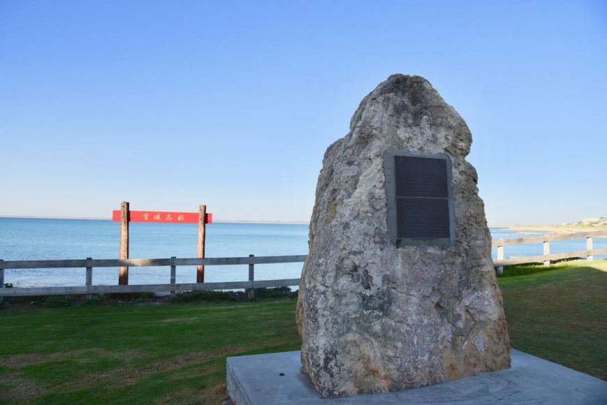
Another interesting memorial to have a look at is the Chinese Memorial. During the years 1856-1858 around 16,500 Chinese landed at Robe and walked the 321 km (200 miles) to the Victorian Goldfields in search of gold.
We then headed off to the Robe Hotel for a meal and some nice cold beverages. The meal was very nice and the service was good. This was reflected by the number of people that were there – it was a struggle to get a table.


Following our meal we drove down to the cliffs at Adam Lindsay Drive and enjoyed the sunset. We then headed back to the motel room where Marija called it a night earlier, whilst I sat back in bed and watched Arnie Schwarzenegger in Predator.

References.
Birds SA, 2018, <https://birdssa.asn.au/location/butcher-gap-conservation-park/>, viewed 13th March 2018
Culture Victoria, 2018, <https://cv.vic.gov.au/stories/immigrants-and-emigrants/many-roads-chinese-on-the-goldfields/walking-to-the-diggings/different-routes/>, viewed 13th March 2018
Department of Environment and Natural Resources, 1994, ‘Small Coastal Parks of the South East Management Plan’.
District Council of Robe, 2018, <http://www.council.robe.sa.gov.au/>, viewed 13th March 2018
kidcyber, 2018, <http://www.kidcyber.com.au/gold-rush-in-australia/>, viewed 13th March 2018
Monuments Australia, 2018, <http://monumentaustralia.org.au/themes/landscape/exploration/display/102986-matthew-flinders-and-nicholas-baudin->, viewed 13th March 2018
National Parks SA, 2018, <https://www.environment.sa.gov.au/parks/find-a-park/Browse_by_region/Limestone_Coast/butcher-gap-conservation-park>, viewed 13th March 2018
Wikipedia, 2018, <https://en.wikipedia.org/wiki/Salt_Creek,_South_Australia>, viewed 13th March 2018
Wikipedia, 2018, <https://en.wikipedia.org/wiki/Kingston_SE>, viewed 13th March 2018

Brilliant write up
Chris
Vk5FR
Hi Chris,
I would have liked to have caught up with Tony VK5ZAI whilst in Kingston but he had a family event on. The south east is certainly a great part of South Australia.
All the best mate.
Paul VK5PAS
Hi Paul
Splendid photos and a splendid meal!
Thanks.
John D
VK5BJE/VK5PF
Hi John,
This was our first time down to Robe together, to have a good look around. There is a lot of history there, along with the great coastline.
When we are away activating, I always enjoying finishing the day with a nice meal and a few drinks.
73,
Paul VK5PAS.