Greenhill Recreation Park VKFF-1712

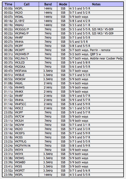
Yesterday (Sunday 26th February 2017) I had a very enjoyable lunch with my wife Marija, our daughter Olivia, our son Jake and his girlfriend Samara, and my Dad and step mum.  Marija served up her very well received, home made lasagne, and we sat underneath the pergola enjoying the sunny warm day.  It was a bit of a celebration for Olivia, who is about to turn 18 and who has just started university where she is studying nursing.

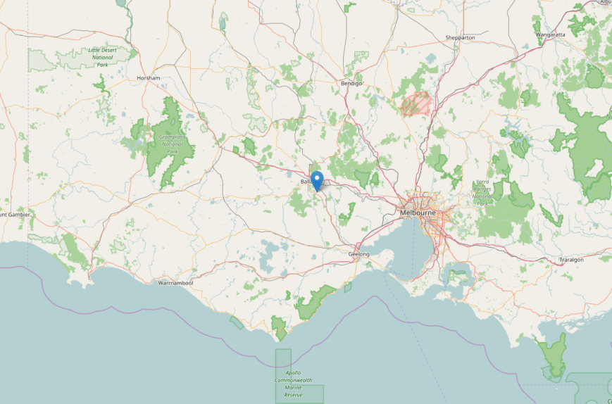
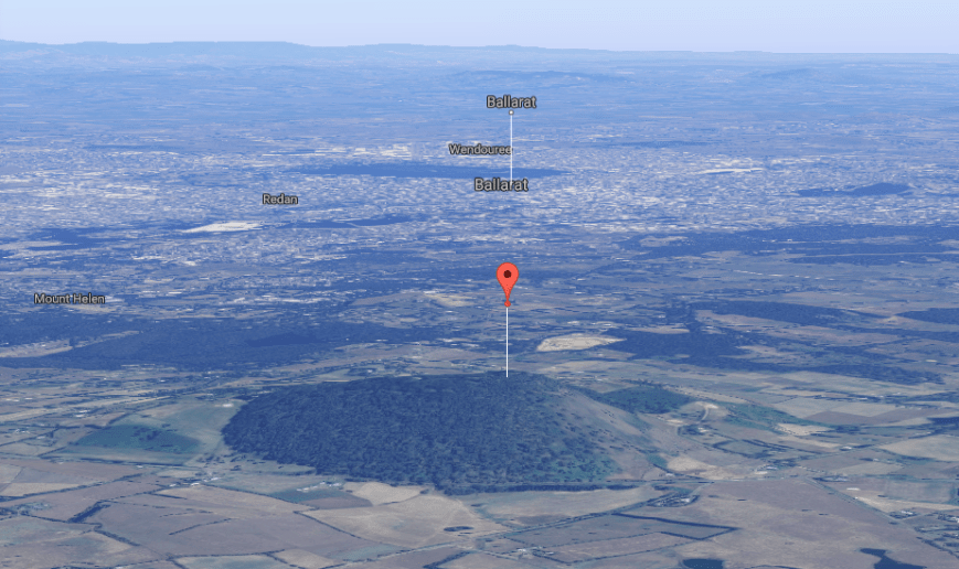
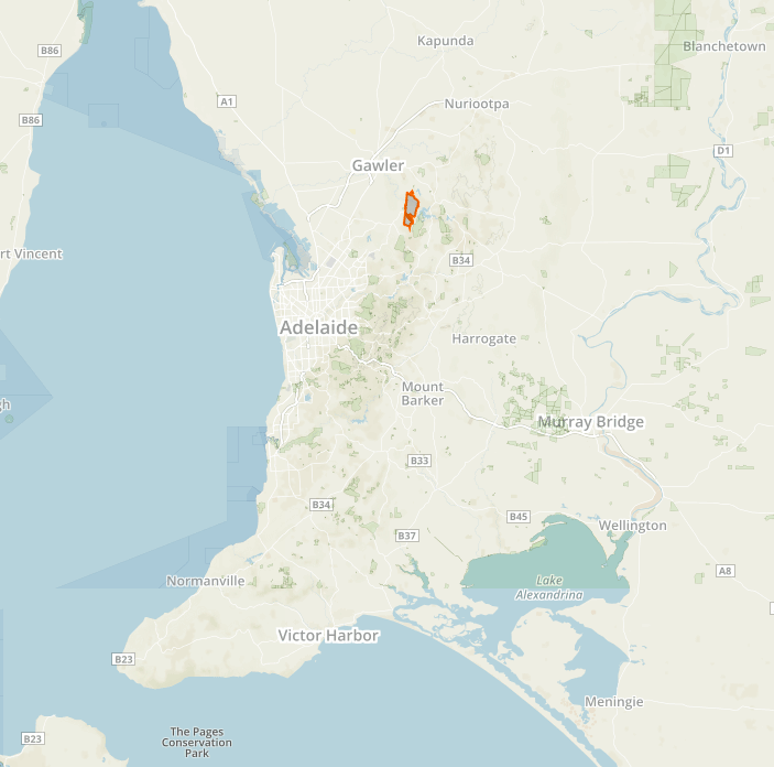
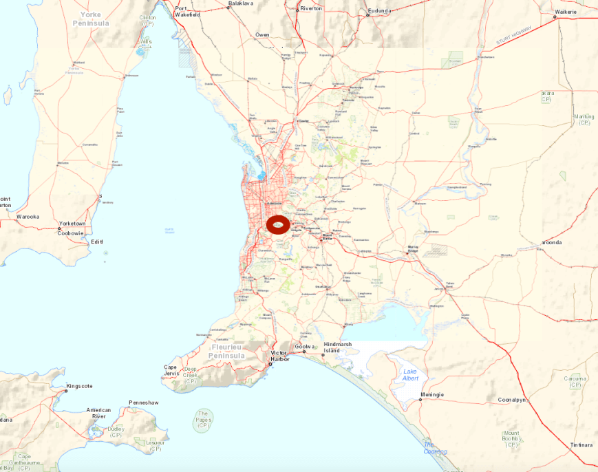
When everyone left just after 3.00 p.m. local time I decided to head out to activate a park.  It was too beautiful a day to be sitting around at home.  I jumped on to the computer and checked out the KML file on Google Earth and decided to head to the Greenhill Recreation Park VKFF-1712.  This was to be a unique park for me, and in fact, the first time the park had been activated for the World Wide Flora Fauna (WWFF) program.  Greenhill is about 7 km east of the city centre of Adelaide, and is located in the foothills of the Mount Lofty Ranges ‘Adelaide Hills’.

Screen Shot 2017-02-27 at 9.30.29 am.png

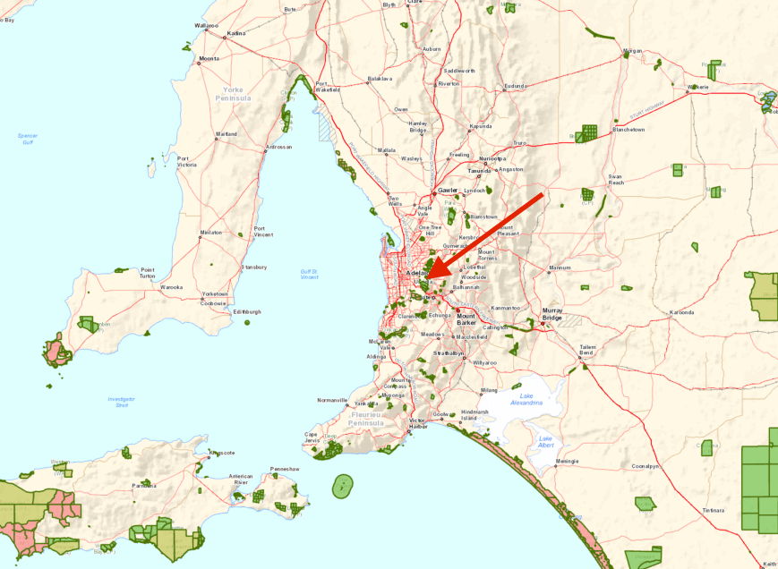
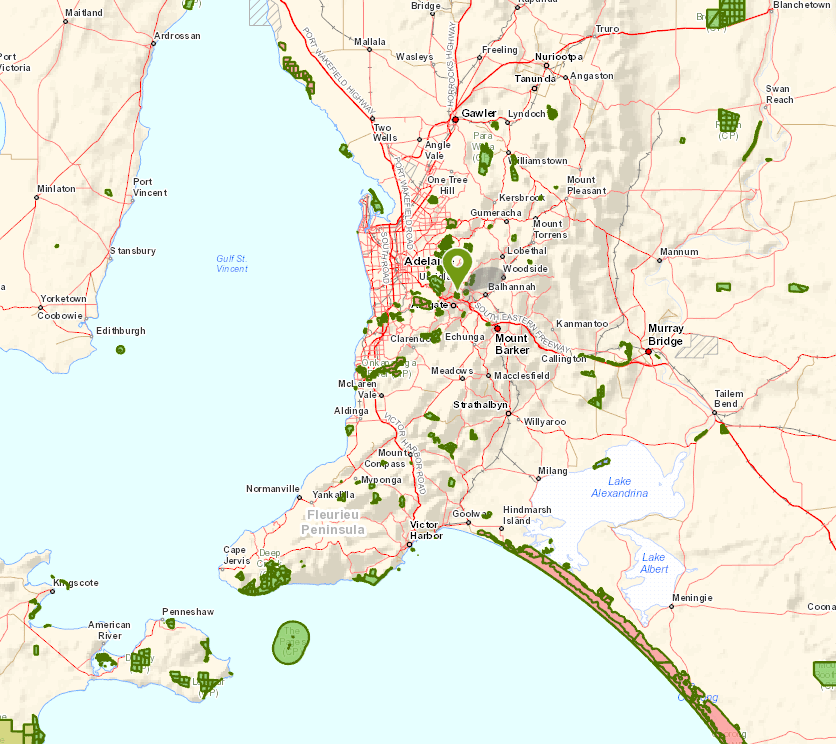
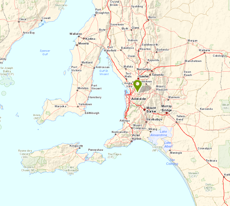
Above:- Map showing the location of the Greenhill Recreation Park, east of Adelaide.  Map courtesy of Location SA Map Viewer.

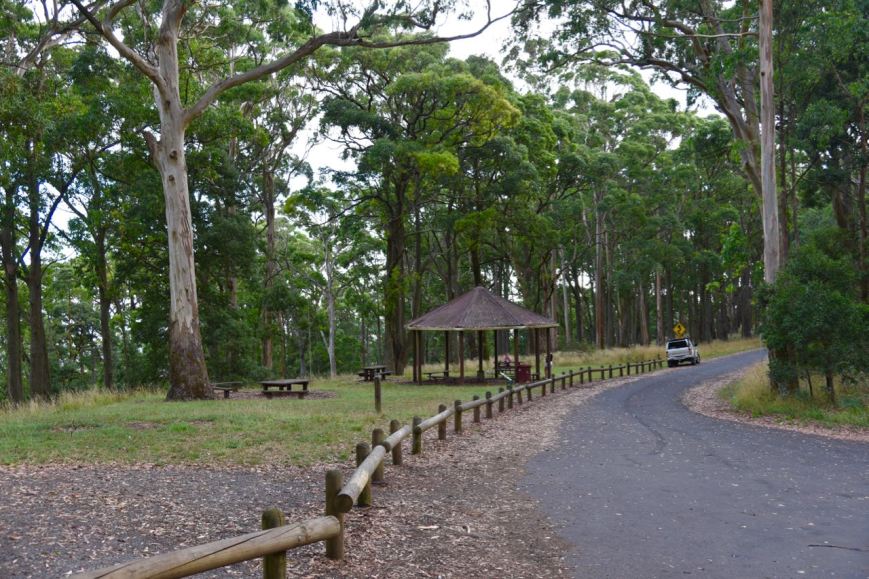
Greenhill  Recreation Park was declared on the 1st January 1952 and is 24 hectares in size.  The park’s vegetation consists primarily of Eucalyptus open woodland over an understorey of grasses, herbs and forbs.  Greenhill’s terrain is quite steep.  A number of walking trails pass through the park.

Screen Shot 2017-02-27 at 9.37.23 am.png

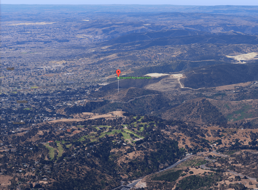
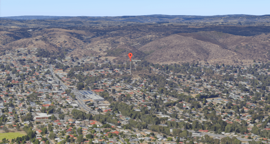
Above:- Aerial shot showing the location of the park in the Adelaide foothills, just above the eastern suburbs of Adelaide.  Image courtesy of google maps.

The area of Greenhill dates back to the mid 1800’s.  Once a road had been constructed in the 1850’s, a number of market gardens, an orchard and dairies were established in the area.  A vineyard was planted by William BREWER, who with his wife Eliza, erected a stone home on Greenhill Road in 1857.

The park’s southern boundary borders Greenhill Road, which today is a busy bitumised road leading from Adelaide’s eastern suburbs up into the Adelaide Hills.  Greenhill Road was originally a rough bullock track leading to the wheat cops and market gardens of Greenhill, Carey Gully, Uraidla and Summertown in the Adelaide Hills.  In 1860, one settler wrote:

“Many families to my certain knowledge are suffering great privations, being unable to bring their commodities to market’.

Another wrote:

“A horse belonging to one of our settlers was thrown down into one of the deep mud-holes upon this road……Persons returning from town are compelled to travel in company,, for it is positively unsafe to travel on this road alone”.

The park is located just down the road from Yarrabee Road Greenhill, which was heavily impacted during the 1983 Ash Wednesday bushfires.  Over 3,700 homes and buildings were destroyed and 75 people lost their lives in South Australia and Victoria.  Of those, five people died at Yarrabee Road, Greenhill.  Nearly 4,200km2  of land was burnt in one day.  To put that into perspective, that is almost twice the size of Luxembourg in Europe.  The Ash Wednesday bushfires were the deadliest on record until February 2009 when 173 people perished on Black Saturday.

Murray Nicoll, a journalist provided reports on Adelaide radio station 5DN, from the fire in the Adelaide Hills.  This included live broadcast of him watching his own house burning to the ground at Greenhill.  

“The sky is red and then white, it’s going crazy, the fire’s jumped 150 feet high straight over the top of Greenhill Road.  I’m watching my house burn down, the roof is falling in, it’s in flames and there’s nothing I can do about it.”

Below is some audio of Murray Nicoll reporting from Greenhill (listen in for some very powerful broadcasting from 1.15 – 4.00)……

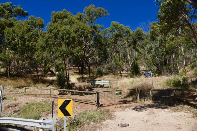
If you wish to activate this park, there are three options.  The first is to park your car in Thorpe Road Greenhill and then walk a short distance uphill to reach the park via Gate three (3).  This was the first point which I checked out.  I decided not to operate from this location as there are houses which back onto this northern section of the park.  There were also power lines.  There is a track which leads uphill, but this meant placing all the gear in a back pack and hiking uphill.  It was a warm day so I decided against that.

dsc_5730

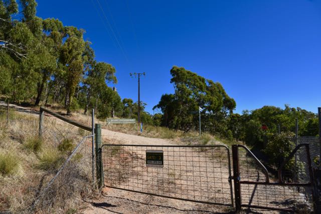
Above:- Gate three at the top of Thorpe Road.

I then drove back up Greenhill Road to gate two (2) which is located on a sharp bend.  There is a small area in front of the date off Greenhill Road which can be quite busy.  But the sign on the gate says to keep the gate clear, no doubt due to access for firefighters in the event of a bushfire.  There are no other parking options there, so this was not going to be an option for me to access the park.

dsc_5731

I continued on Greenhill Road to gate one (1) which is located near the bus stop.  There was an area here for me to park the vehicle off Greenhill Road.

dsc_5733

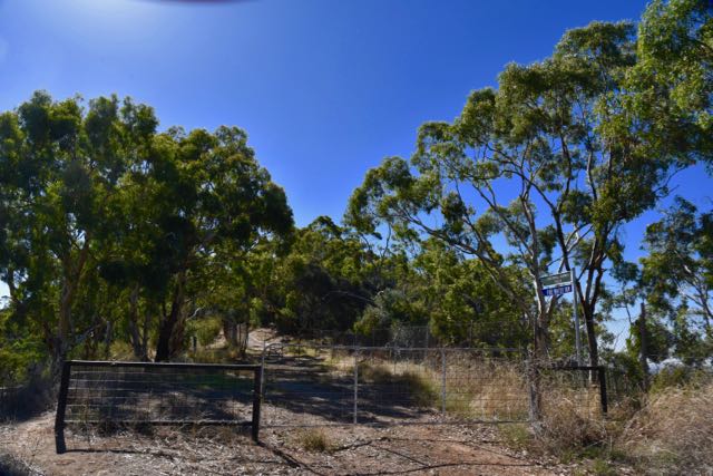
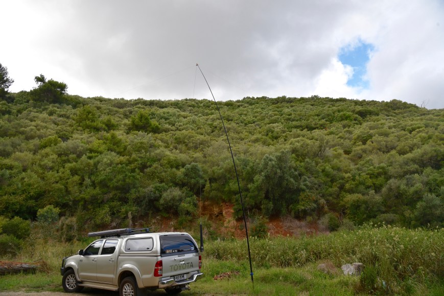
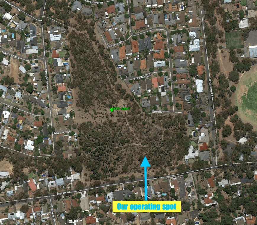
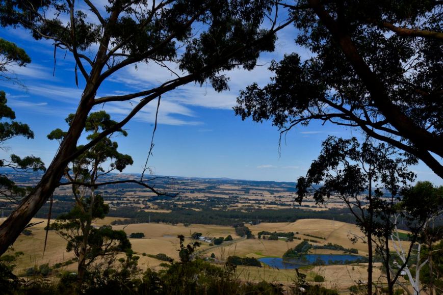
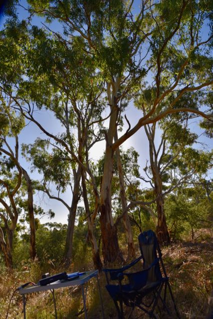
I walked a short distance up the track which overlooked Greenhill Road and Chambers Gully.  I made as much noise as possible to scare aware any snakes, as it was a warm and sunny day.  I made a couple of trips back to the vehicle to collect gear.  For this activation I ran the Yaesu FT-857d, 30 watts output, and the 80/40/20m linked dipole, supported on the 7 metre heavy duty telescopic squid pole.

Screen Shot 2017-02-27 at 9.29.51 am.png

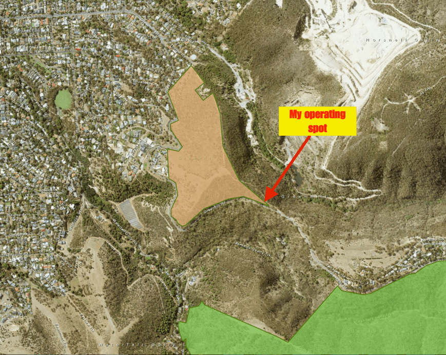
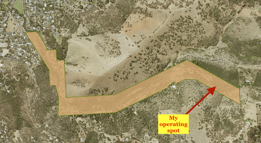
Above:- Aerial shot of the Greenhill Recreation Park, showing my operating spot in the south eastern corner.  Image courtesy of Location SA Map Viewer.

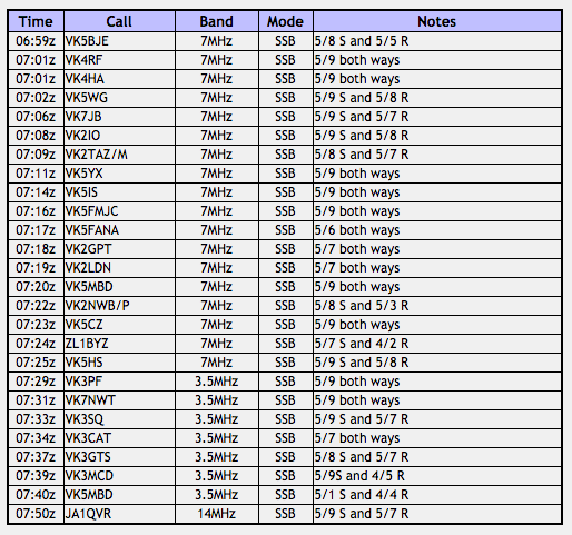
After finishing setting up I headed to 7.144 on 40m and started calling CQ.  It took around 5 minutes of CQ calls for my first station to be logged.  It was Brian VK3BBB who was a good 5/8, but gave me a 5/2.  Oh no, this was not a good sign.  Next up was Mark VK3PI who was 5/9 plus and reciprocated with a 5/9 for me.  That was better.  I had intially thought that the band conditions were going to be quite poor.

It was very slow going for the first part of this activation.  Contact number ten, qualifying the park for me for VKFF, was Rhett VK3WE.  This was after 20 minutes of being on air.  I was also experiencing S7 static crashes and quite a bit of QRM from European stations, who sadly were unable to hear my signal.  I went on to work a total of 24 stations on 40m from VK1, VK2, VK3, VK4, VK5, and VK7.  It was looking as though it was going to be hard work reaching the 44 QSOs required to qualify the park for the WWFF global program.

I then lowered the squid pole and removed the links and headed off to 14.310 on 20m.  My first taker there was John VK6NU, whose signal was down very low, but we managed to make a good contact (5/3 sent and 5/1 received).  Next was Fran OK7WA in the Czech Republic with a good 5/5 signal (4/4 received).  This was followed by Fuji JA8DCR in Japan (5/9 sent and 5/7 received), Max IK1GPG in Italy (5/7 sent and 5/5 received), and Hinko S52KM in Slovenia (5/7 sent and 3/3 received).  I then logged Hans VK6XN in Western Australia, Danny ON4VT In Belgium, and finally Joe VK5WU.
dsc_5734

I had received a test message from Adrian VK5FANA, advising that he was patiently waiting for me on 80m and that he was unable to hear me on 40m.  So I inserted the links in the dipole and headed to 3.610 on the 80m band.  Adrian VK5FANA was the first in the log on 80m (5/7 sent and 5/8 received).  I went on to log a further 6 stations on 80m, from VK1, VK3, and VK5.  This included Les VK5KLV at Port Augusta.  It was a real struggle with Les, who was hearing me better that I was hearing him.  But we made it in the end due to the tenacity and persistence of Les (3/3 sent and 5/3 received).

I now had a total of 39 contacts in the log, with just 5 more to go for me to qualify the park.  I headed back to 7.144 and started calling CQ, but within a minute or so, the WIA broadcast commenced on 7.146, so I QSYd to 7.135.  There I logged Howard VK3QA and Brett VK2WWV, but I was again forced to QSY, as a JA station came onto the frequency calling CQ.  He was 5/9 and I was unable to compete with his very strong signal.

I then moved up the band to 7.160 where I worked a further 17 stations from VK2, VK3, VK4, VK6, VK7 and New Zealand.  At 0900 UTC, another WIA broadcast kicked off on 7.158, just below me.  I now had 58 contacts in the log, and had qualified the park, so I decided to have a quick look around the band before going QRT and heading home.

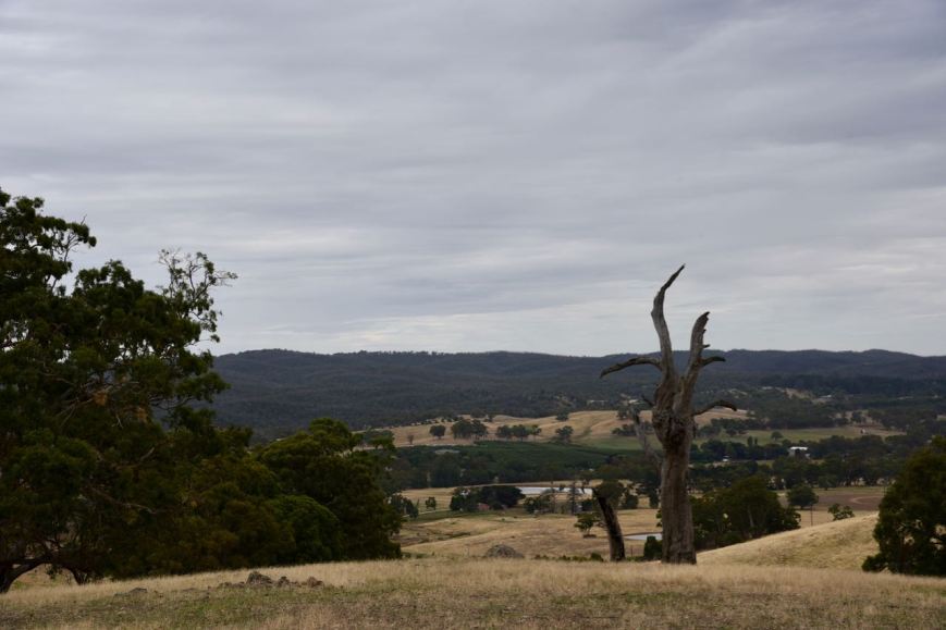
I found Jarrad VK3BL and Jim VK2QA chatting on 7.115, so I popped in to say a quick hello.  As I was signing with Jarrad and Jim, Roy VK7ROY came up to say hi, and we QSYd a bit further up the band to 7.130.  I also worked Roy’s friend Mark VK7FAAZ who has just become a licenced amateur.  It was a pleasure to be Mark’s first contact.  I worked a further 9 stations on 7.130 from VK2, VK3, VK6, and VK7, before hitting the switch and calling it an evening.  It was now almost dark and I wanted to pack the gear away before it was completely pitch black.  There was a lovely sunset to be enjoyed and some great views of Adelaide from the park.

I ended up with a total of 70 contacts in the log on 80, 40, and 20m from VK1, VK2, VK3, VK4, VK5, VK6, VK7, New Zealand, Slovak Republic, Japan, Italy, Slovenia, and Belgium.

I worked the following stations on 40m SSB:-

  1. VK3BBB
  2. VK3PI
  3. VK3CBP
  4. VK1AT
  5. VK3PAT/p
  6. VK4FW
  7. VK3GGG
  8. VK3PMG
  9. VK7JON
  10. VK3WE
  11. VK2NSS
  12. VK3FCMC
  13. VK3FSPG
  14. VK3MPR
  15. VK3ANL
  16. VK3TJK
  17. VK2DI
  18. VK2NNN
  19. VK5SFA/m
  20. VK3VIN
  21. VK3FSLG
  22. VK3FPSR
  23. VK3OHM
  24. VK3BQ/m
  25. VK3QA
  26. VK2WWV
  27. VK6OP
  28. VK3VLA
  29. VK3QD
  30. VK7BC
  31. VK4HNS/p
  32. VK3FMDC
  33. VK3GK/2
  34. ZL1AAW
  35. VK4NH
  36. VK4SJ
  37. VK3HSB
  38. VK2GPT
  39. VK2LDN
  40. VK4SMA
  41. VK3ELH
  42. VK7PSJ
  43. VK2HPN
  44. VK3BL
  45. VK2QA
  46. VK7ROY
  47. VK7FAAZ
  48. VK2FOUZ
  49. VK6WE
  50. VK3ALA
  51. VK2QK
  52. VK7FPRN
  53. VK7FRJG
  54. VK3DPG
  55. VK7VZ
  56. VK6FCAO

I worked the following stations on 20m SSB:-

  1. VK6NU
  2. OK7WA
  3. JA8DCR
  4. IK1GPG
  5. S52KM
  6. VK6XN
  7. ON4VT

I worked the following stations on 80m SSB:-

  1. VK5FANA
  2. VK3BSG
  3. VK3GGG
  4. VK3PMG
  5. VK5WU
  6. VK1DI
  7. VK5KLV

References.

Nicol, S, 1997, ‘RAA touring, Adelaide Region’

Wikipedia, 2017, <https://en.wikipedia.org/wiki/Greenhill_Recreation_Park&gt;, viewed 27th February 2017

Brownhill Creek Recreation Park VKFF-1688

Yesterday (Sunday 19th February 2017) I met up with a good mate and work colleague for some lunch over at Meadows in the Adelaide Hills.  As we sat indoors enjoying our meal I couldn’t help but notice the quite heavy rain outside.  I had planned on heading down to the foothills of Adelaide after lunch to activate the Brownhill Creek Recreation Park VKFF-1688, and it wasn’t looking promising.  But at the conclusion of lunch, I decided to take my chances.  Fortunately the rain cleared to intermittent showers as I got closer to town.

The Brownhill Recreation Park is situated about 8km south east of the city centre of Adelaide.  This was to be the first time the park had been activated for the World Wide Flora Fauna (WWFF) program, so it was to be a unique park for me as an activator and a unique park for all the WWFF hunters.

screen-shot-2017-02-19-at-8-34-55-pm

Above:- Map showing the location of the Brownhill Recreation Park, south east of Adelaide.  Map courtesy of Location SA Map Viewer.

Brownhill Creek Recreation Park is 51 hectares in size and is located in the foothills of the Mt Lofty Ranges, ‘Adelaide Hills’.  The park is a popular multi-use recreation area which is also valued for its historic and scenic attractions.  The park is linear in shape, with an average width of just 200 metres.  It follows Brownhill Creek for about 4 km.

The creek flows through a steep sided valley with majestic River Red gums, some of which are more than 300 years old.  Blue Gum woodland climbs the valley slopes which are dotted with golden wattle.  The park also supports a small threatened, ecosystem of greybox grassy woodland.  The park contains 27 plant species of conservation significance, including 5 at State level.

With the clearing of much of the native vegetation during the 1800’s for crops and sheep grazing, also came the introduction of numerous exotic species.  Willows, Oaks, Poplars, and Walnut trees can still be found in the park today.  The revegetation of the park with native species is gradually progressing thanks to the efforts of the Friends of Brownhill Creek Group.

Brown Hill summit can be located in the park.  Unfortunately it does not have sufficient ‘prominence’ to qualify for the Summits on the Air (SOTA) program.  However, if you are keen to climb to the top, you will be rewarded with some great views.  Brown Hill itself appears as one of the trig points for the first survey of land in South Australia during 1837 and 1838.  These maps were published by the British Parliamentary House of Commons in 1841.

The creek valley is a natural wildlife corridor for over 40 species of birds and mammals.  Native animals that are found in the park include the Brush Tailed Possum, Koala, Ruing-tailed possum, Swamp Rat, Bush Rat, Echidna, and the endangered Southern Brown Bandicoot.   The Southern Brown Bandicoot was once widespread across the Mount Lofty Ranges, but due to heavy predation by foxes, numbers have declined dramatically.  Bird species in the park include the Kookaburra, Little Wattlebird, Superb Fairy wren, Rainbow Lorikeet, Yellow-tailed Black Cockatoo, and White-faced Heron.

A number of bat species are also found in the park including Goulds Wattled Bat, Chocolate Wattled Bat, Southern Freetail Bat, Lesser Long Eared Bat, and Large Forest Bat.  Various reptile species can be found in the park including Eastern Brown snake, Sleepy Lizard, Eastern Bearded Dragon, Eastern Blue-rongue lizard, Barking Gecko, and the Creamed-striped Shining Skink.  Amphibians found in the park include the Common Froglet, the Bull Frog, and the Brown Tree Frog.

South Australia was proclaimed on the 28th December 1836 and by 1837 the SA Company established the No. 1 Sheep Station along the Brownhill Creek valley to hold sheep overhanded to feed the colony of South Australia.  One of the earliest outlying communities to spring up in the new colony of South Australia was that of Mitcham, in 1840.  Mitcham is located just below the current day Brownhill Creek Recreation Park.  There are numerous historic buildings remaining in Mitcham dating back to the 1880’s, with interpretive signs explains their historical importance.  I took a short detour into Mitcham to have a look.

The Brownhill Creek area was once an important camping, hunting and gathering ground for the Kaurna Aboriginal people. The Kauna people called the area Wirraparinga, meaning “creek and scrub place”.  One of the first Europeans to settle in the area was Pastor William Finlayson who arrived in 1837. He observed that Brownhill Creek was ‘a gathering place for Aboriginal people with as many as a hundred and fifty camping there at any one time‘.

220px-william_finlayson_1875_b14655

Above:- Pastor William Finlayson. Image courtesy of Wikipedia.

By 1840, agriculture, market gardening and quarrying were important local industries in the Brownhill Creek area.  Much of the native vegetation was cleared for crops and sheep grazing, along with the introduction of exotic species.

In 1841 Brownhill Creek was set aside for ‘public purposes‘, making it one of the oldest parks in South Australia.  This followed the finding of a specimen of freestone which was obtained from a quarry recently opened near Brownhill Creek.  The land surrounding the reserve was progressively surveyed up until 1854, consequently the Brownhill Creek Reserve did not appear on maps for the area until 1858.

screen-shot-2017-02-19-at-10-24-46-pmAbove:- Two young men resting at Brownhill Creek c. 1885.  Image courtesy of Trove.

By 1868 quarrying in the Brownhill Creek area had become a major industry for the district by providing building material, road metal and ballast for the railways and the Outer Harbour breakwater for the following 100 years.  Reminders of the quarrying days in the park can still be found.  Viney’s bluestone quarry once provided a source of large blocks of bluestone for buildings down in Mitcham, Parkside, and Eastwood, and for lining gutters and kerbing in Hindley and Rundle Streets in Adelaide.  Mundy’s rock crushing plant from which road metal was obtained, can also be seen.

dsc_5676
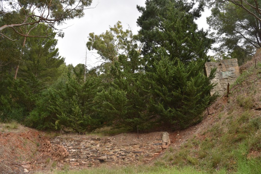
Above:- The stone wall ruins of Mundy’s rock crushing plant.

In 1874 the Brownhill Creek Chapel was built, just outside the current day park boundary, at the junction of Tilleys Hill and Brownhill Creek Roads. The Chapel was a branch of the Mitcham Baptist Church.  Mrs Joseph Grigg, as one of the oldest residents in Brownhill Creek at the time, had the honour of installing the foundation stone which can now be found at the site of the Monarch of the Glen in the caravan park.  From 1893, the chapel was used as a school for children who lived on the market gardens. The building was then used as a private home until 1942 when it was burned down in a bushfire and vandalised, leaving only the foundation stone.

Above:- A view of the Brownhill Creek Chapel in the valley (left), and the interior of the Chapel (right).  Images courtesy of Trove.

During the late 1880’s the reserve was placed under the control of the District Council of Mitcham by proclamation made under the Crown Lands Act 1888 and the District Councils Act 1887.  It was during this time that two sets of stone and pug manure pits were built, one in 1891, and another in 1893.  The purpose of the pits was to prevent pollution of the creek due to market gardening in the valley.  An 1869 letter by a Mr. John Calf brought attention to the quality of manure that market gardeners were depositing on the reserve.  A decision was made to investigate the issue, but it would not be until 22 years later that Mr. Alf Terry, on behalf of the Mitchum Council, built the two sets of pits to store horse manure used as fertiliser for local market gardens.

During 1893 swimming baths were constructed for public recreation.  It is recorded that in 1902 a local market gardener, T, Newey, complained to the Mitcham Council that the baths were interfering with the natural flow of the creek and market gardening options.  As a result the council resolved that “all dams on the creek be destroyed and no further bathing allowed“.

The Mitcham Council continued management of the park until 15th July 1915, when it became known as the Brownhill Creek National Pleasure Resort.  It was declared as a Recreation Park in 1972 “in order to provide recreation opportunities for the Adelaide and eastern metropolitan region and to conserve remnant aged river red gums and the riparian zone habitat.

I accessed the park via Brown Hill Creek Road which runs through the centre of the park.  At the entrance to the park is a memorial stone declaring Brownhill Creek Reserve as a National Pleasure Resort.  A hanging sign displaying the name of the park originally swung here.  The Brownhill Creek Tourist Park (caravan park) is also located at the western end of the park.

You can also access the park on foot from Northbrook Avenue in the north western corner of the park.  There are a number of car parking spots dotted throughout the park, as there are numerous picnic areas with picnic tables.  Unfortunately I was not going to be able to take advantage of those during this activation due to the intermittent rain.

I stopped off to have a look at a large River Red gum (Eucalyptus camaldulensis), known as the ‘Monarch of the Glen’.  The tree which is located in the grounds of the Brownhill Creek Tourist Park, is estimated that the tree is around 400 years old.  By the 1830’s when European settlers came to the area, the trunk of the tree had already been burnt out, suggesting that the hollow trunk once sheltered the Kauna aborigines.  Settlers who camped near the creek used the hollow trunk as a temporary home and it is reported that several settlers even gave birth inside the tree.

I also stopped to have a look at White’s Bridge which is one of the earliest structures in South Australia.  It was originally a wooden structure until 1919, when Mitcham Council received a government grant to construct a new reinforced concrete bridge, with the contribution of local rate payers.  Brown hill Creek Road which dissects the park can be traced back to a letter received by the Mitcham Council in 1869 from quarry owner and resident H Mundy asking permission to cut a road through the reserve to his house.  The request was approved and a formal road was constructed.

I drove all the way to the eastern end of the park and then turned back around.  Brownhill Creek Road continues on for a few km but is marked for local traffic only.

I found a small clearing off the road near the Creek, and in between the showers I set up the 80/40/20m linked dipole, supported on the 7m squid pole.  The shower activity was just too regular for me to set up outside, so I operated from the vehicle for this activation, which ordinarily I do not like doing.  I much prefer being out in the open air, sitting back in a deck chair.  That was not an option on this occasion.

Screen Shot 2017-02-19 at 8.34.27 PM.png

Above:- Aerial shot of the park showing my operating spot.  Image courtesy of Location SA Map Viewer.

I had alerted on parksnpeaks that I was to be on air by 0400 UTC and I was all set up and ready to go by 0354 UTC (1.24 p.m. South Australian local time).  There were some power lines following Brownhill Creek Road but I was pleased to note when I switched on the Yaesu FT-857d that there was no man made noise on the 40m band.  There was the occasional static crash which was reaching strength 5.  So conditions were very good.

I called CQ on 7.144 and this was answered by Paul VK3HN who had a good 5/9 signal from Melbourne.  This was followed by Steve VK5KSW at Wool Bay near the bottom of the Yorke Peninsula.  Steve had a strong 5/8 signal coming across the Gulf St Vincent about 100 km away.  I had not checked the HAP chart for Adelaide so I was unsure what propagation was expected to be like around South Australia.  Of recent times the close in propagation has often been non existent on the 40m band.  But my contact with Steve was a pleasing sign of things to come for contacts around VK5 during this activation.

Contact number 10 was Peter at Strathalbyn, about 50 km south of the park.  Peter was a little bit of a struggle to me (3/1) despite the band being very quiet, with Peter receiving me a little better (5/3).  A few calls later Andrew VK5CV called me from nearby Netherby with a massive 5/9 plus signal, on ground wave.  Contact number 23 was Les VK5KLV at Port Augusta, about 300 km north of the park.  Les was 5/9 and reciprocated with a 5/9 for me.

At this stage of the activation it appeared that contacts within 100 km were highly improbable on 40m.  If they were there, signals were going to be well down as indicated by my contact with Peter VK5PET.  But a few calls later after my QSO with Les I was proven to be wrong.  Trevor VK5TW gave me a shout (5/7 sent and 5/3 received) from nearby Bellevue Heights in the Adelaide foothills.  I then spoke with Rob VK5TRM in the Riverland region about 350 km to the north east (5/9 both ways), and then John VK5BJE in the Adelaide Hills (5/9 sent and 5/5 received).  This was followed by Jeff VK5JK at Encounter Bay near Victor Harbour, about 80km to my south.  Jeff advised that a few minutes earlier he could not hear me, but that my signal was now 5/9.  I also logged Adrian VK5FANA on the Yorke Peninsula, David VK5PL in the southern Barossa Valley, Greg VK5GJ at Meadows in the Adelaide Hills, Shaun VK5FAKV in the Riverland, and Andrew VK5MAS at Mount Gambier about 400 km to the south east.

dsc_5682

During the activation I had a steady flow of callers on 40m from VK1, VK2, VK3, VK5, and VK7, all with good signals.  Within 90 minutes I had 44 contacts in the log, with David VK5PL in the southern Barossa Valley being number 44, qualifying the park for me for WWFF.  I also made a Park to Park contact with Ian VK1DI who was in the Mount Painter Nature Reserve VKFF-0853.

After logging 51 stations on 40m I headed to 14.310 on the 20m band.  I asked if the frequency was in use and didn’t hear anyone reply so I started calling CQ.  After a few CQ calls I heard someone calling VK1DI.  The station was very very weak and I could not hear VK1DI at all.  I checked parksnpeaks and saw that Ian VK1DI was on 14.310.  Sadly it was an indication that there was not going to be any propagation into New South Wales and the ACT on 20m.

I headed up to 14.315 and started calling CQ.  In the middle of my CQ calls I heard a voice ask ‘is the frequency in use’.  It was Alex VK4TE who was about call CQ.  I logged Alex who was a strong 5/8 to Brownhill Creek.  Unfortunately despite numerous CQ calls, the only other stations logged on 20m were Daniel VK6WE and John VK6NU, both in Western Australia.  I tuned across the 20m band and heard just a few weak DX stations.  The strongest (5/5) was 4X6TT in Israel, who I called, but sadly he was unable to hear me.

I then headed to 3.610 on the 80m band and started calling CQ.  My call was answered by Greg VK5GJ at Meadows in the Adelaide Hills, running QRP 4 watts (5/7 sent and 5/9 received).  Next up was Dean VK5LB on the Fleurieu Peninsula, south of Adelaide with a lovely 5/9 signal.  Peter VK5KPR at Port Augusta, 300 km to my north, then called me with a good 5/7 signal.  Peter gave me a 5/5 signal report and advised he was suffering a bit from noise.  Whereas for me in the park there was no man made noise at all on 80m.  If only it was like that at home.  Next I spoke with Hans VK5YX who also advised he had S9 noise, but I was above that into the southern suburbs of Adelaide.  I logged a further 4 stations, Mike VK5FMWW/VK5FVSV, Shaun VK5FAKV in the Riverland, and finally Tim VK5ML.

I then lowered the squid pole and removed the linked dipole and erected the 15m dipole and put a few CQ calls out on 21.244 but had no takers.  So with 62 contacts in the log, and a unique park activated, it was time to head home.

I worked the following stations on 40m SSB:-

  1. VK3HN
  2. VK5KSW
  3. VK3CWF
  4. VK3FSPG
  5. VK3MPR
  6. VK3ANL
  7. VK3FCMC
  8. VK3FRJD
  9. VK2HHA
  10. VK5PET
  11. VK3FORD
  12. VK3SOT
  13. VK3FFB
  14. VK3OHM
  15. VK5CV
  16. VK3ZPF
  17. VK2IO
  18. VK3XL
  19. VK3ARH
  20. VK7VEK
  21. VK3PF
  22. VK2TTP
  23. VK5KLV
  24. VK3SQ
  25. VK2NEO
  26. VK3MRH
  27. VK3PNF/m
  28. VK2UH
  29. VK3BNJ
  30. VK5TW
  31. VK5TRM
  32. VK2YW
  33. VK5BJE
  34. VK3IRM
  35. VK5JK
  36. VK1DI/p (Mount Painter Nature Reserve VKFF-0853)
  37. VK3MCK
  38. VK5FANA
  39. VK2GPT
  40. VK2LDN
  41. VK3FNQS
  42. VK2FOUZ
  43. VK3DN
  44. VK5PL
  45. VK3CEK
  46. VK3ZMD
  47. VK5GJ
  48. VK5FAKV
  49. VK3VLY
  50. VK3VIN
  51. VK5MAS

I worked the following stations on 20m SSB:-

  1. VK4TE
  2. VK6WE
  3. VK6NU

I worked the following stations on 80m SSB:-

  1. VK5GJ
  2. VK5LB
  3. VK5KPR
  4. VK5YX
  5. VK5FNWW
  6. VK5FVSV
  7. VK5FAKV
  8. VK5ML

References.

City of Mitcham, 2017, <http://www.mitchamcouncil.sa.gov.au/bushlandreserves&gt;, viewed 19th February 2017

Department for Environment and Heritage, 2003, Brownhill Creek Recreation Park Management Plan

National Parks South Australia, 2017, <http://www.environment.sa.gov.au/parks/Find_a_Park/Browse_by_region/Adelaide_Hills/brownhill-creek-recreation-park&gt;, viewed 19th February 2017

Wikipedia, 2017, <https://en.wikipedia.org/wiki/Brown_Hill_Creek&gt;, viewed 19th February 2017

Mount George Conservation Park 5CP-147 and VKFF-0784

Yesterday afternoon (Friday 17th February 2017) for the Friday afternoon/evening event for the VK5 National & Conservation Parks Award I activated the Mount George Conservation Park 5CP-147 and VKFF-0784.  The park is approximately 25 km south-east of Adelaide near the town of Bridgewater.

I have activated this park many times before in the past and have well and truly qualified it for the World Wide Flora Fauna (WWFF) program, so this activation was purely for the VK5 Parks Friday event.

Screen Shot 2017-02-17 at 8.17.52 PM.png

Above:- Map showing the location of the Mount George Conservation Park.  Image courtesy of Location SA Map Viewer.

Mount George Conservation Park which was proclaimed on the 7th November 1996,  conserves 85 hectares of important native vegetation in the Mount Lofty Ranges ‘Adelaide Hills.  The park is characterised by steep slopes which are adorned with Stringybark Open Forest.  The park contains a number of creeks including Cox Creek and Cascade Creek, wetlands, and freshwater bogs and soaks.  These provide important habitat for numerous native fauna species.   State endangered Mountain Gum Open Forest is generally found within the vicinity of these damper areas, particularly near the base of the gully that runs through the centre of the park. The park protects a diverse assemblage of flora, with several species considered to be threatened at a national, state or regional level, such as the nationally vulnerable Clover Glycine and the state endangered Mountain Gum.  Mount George summit, 520m ASL is located within the park.

A total of 15 native species of mammals have been recorded in the park including the Common Ring-tail Possum, the Yellow-footed Antechinus, Western Grey Kangaroo, Koalas, the Lesser Long-earred Bat, the Bush Rat, the Echidna and the Common Brushtail Possum.  The Southern Brown Bandicoot, which is considered vulnerable in South Australia is also found in the park.  A total of 66 species of birds have been documented in the park including the Bassian Thrush, Super Blue Wren, Yellow-tailed Black Cockatoo, Peregrine Falcon, Scarlet Robin, Red-browned finch, and Crested Shriketit.  A total of 14 species of reptiles and seven species of amphibians have been recorded in the park.

Images above courtesy of wikipedia.

During the 1840’s much of the land in the Mount Lofty Ranges was cleared for farming and mountain gardening.  The land which would become the Mount George Conservation Park was acquired by the then National Parks and Wildlife Service in 1989.  The park was originally 67 hectares before the boundaries were extended in 2003 to incorporate adjacent land of high conservation value.  An additional 18 hectares of land was added to the park on 16 October 2003.

There are a number of walking trails to explore in the park.  A section of the 1,200 km long Heysen Trail passes through the park.  Dogs can also be walked in the ‘recreation zone’ of the park, but they must be kept on a lead and under control.  Sadly, each time I have been to this park, this has not been the case.  There have been dogs and their owners, but the dogs have certainly not been on a lead.  And this activation was no exception.

When I arrived at the park there were about half a dozen people in the park all with their dogs, running free through the park.  Some of which came up to me, jumping onto me, and getting caught up in the coax.  I ran the Yaesu FT-857d set at 40 watts output and the 80/40/20m linked dipole sitting on the top of the 7 metre telescopic squid pole.

Screen Shot 2017-02-17 at 8.14.30 PM.png

Above:- Map showing my operating spot in the Mount George Conservation Park.  Map courtesy of Location SA Map Viewer.

After setting up I headed to 7.144 on the 40m band and started calling CQ.  It was quite noisy on the band with static crashes up to strength 8.  The map below shows all of the lightning activity around Australia resulting in the noisy band.  It took a few minutes before my first caller was logged.  It was Peter VK3PF who was a good 5/9 signal.   Next up was Peter VK3HSB who was portable in the Lake Eildon National Park VKFF-0625.  It was nice to get an unexpected Park to Park contact in the log.  I then spoke with Les VK5KLV at Port Augusta who was 5/9 plus.  Port Augusta is around 330 km north of Mount George, so it was clear that there was good propagation around South Australia at least out to that distance.

screen-shot-2017-02-17-at-8-30-38-pm

Map of Australia showing lightning activity.  Image courtesy of weatherzone.com.au

I was just a few minutes into the activation when it started to drizzle with rain, right in the middle of my fourth QSO which was with Stuart VK3STU.  I was about ready to run back to the vehicle, when the showers cleared as quickly as they had appeared.  I worked just 3 more stations on 40m, all from VK3.  It was the quietest I had heard it on the band during  a park activation, for a long time.  I suspect the static crashes were certainly contributing to that.  I was pleased to log a new amateur to the bands, Robert VK3FRCS, who has just been licensed for a few months.

I lowered the squid pole and removed the links for operation on the 20m band.  Whilst I was doing this I had an interested onlooker approach me and ask inquisitively what I was up to.  I explained to him that I was an amateur radio operator, and told him a little bit about the hobby and the various parks awards.  He seemed quite interested and had heard of amateur radio previously.

I then started calling CQ on 14.310.  This was answered by John VK4TJ in Queensland with a lovely 5/9 signal.  John advised that VK3JBL was also on the frequency (I was unable to hear him), so I QSYd up to 14.315 where I spoke with Rick VK4RF/VK4HA who was 5/9 plus.  Rick advised that Gerard VK2IO was trying for me, but I could not hear a peep from Gerard, so band conditions into the eastern States appeared to be very poor.  Sadly, the drizzle started up again and this resulted in me having to hide underneath my both bag.  I must have been a strange sight…..somebody hiding underneath a bright orange piece of plastic with a squid pole in the air alongside of them.

As the weather was less than ideal I quickly headed off to 3.610 on 80m where I logged Mick VK3GGG/VK3PMG in western Victoria who was 5/9, and then Hans VK5YX in the south suburbs of Adelaide.  Hans was 5/9 plus.  To complete the activation I headed back to 7.144 on 40m and logged just 2 further stations, Craig VK2KDP, and Gerard VK2IO.  Both advised that there had been storms in Sydney and they were suffering quite badly from static crashes.

Sadly the weather had really started to set in, with rain falling a little heavier.  So rather frustrated, I packed up and headed home.  Not one of my best activations.

I worked the following stations on 40m SSB:-

  1. VK3PF
  2. VK3HSB/p (Lake Eildon National Park VKFF-0625)
  3. VK5KLV
  4. VK3STU
  5. VK3SFG
  6. VK3FRCS
  7. VK3MCK
  8. VK2KDP
  9. VK2IO

I worked the following stations on 20m SSB:-

  1. VK4TJ
  2. VK4RF
  3. VK4HA

I worked the following stations on 80m SSB:-

  1. VK3GGG
  2. VK3PMG
  3. VK5YX

References.

Department for Environment and Heritage, 2006, Mount George Conservation Park Management Plan

National Parks SA< 2017, <https://www.environment.sa.gov.au/parks/Find_a_Park/Browse_by_region/Adelaide_Hills/mount-george-conservation-park&gt;, viewed 17th February 2017

Angove Conservation Park 5CP-005 and VKFF-0867

Yesterday afternoon (Saturday 11th February 2017), my wife VK5FMAZ and I headed up to the northern suburbs of Adelaide to pay my Dad and stepmum a visit who are in their 80’s.  We spent an enjoyable few hours with them, including discussing their next cruise to Papua New Guinea, Vanuatu and New Caledonia.  I only hope I’m that active when I (if) am their age.  On the way home Marija and I detoured into the Angove Conservation Park 5CP-005 and VKFF-0867 for a park activation.  This was to be a unique park for both of us, for both the World Wide Flora Fauna (WWFF) program and the VK5 National & Conservation Parks Award.

Angove Conservation Park is located about 16 km north east of Adelaide, situated in the foothills between the Adelaide Plains and the Mount Lofty Ranges ‘Adelaide Hills’.

Screen Shot 2017-02-12 at 10.25.25 am.png

Above:- Map showing the location of the Angove Conservation Park in the north eastern suburbs of Adelaide.  Image courtesy of Location SA Map Viewer.

Angove Conservation Park is about 5 hectares (12 acres) in size and conserves one of the last remaining stands of remnant drooping sheoak and southern cypress pine open woodlands within the Adelaide foothills.   The park which was proclaimed on the 23rd June 1994 contains 142 native plant species and provides specialised habitat for a small number of animals that require dense vegetation to survive.   Several species of reptiles can also be found, along with mammals such as ringtail and brush-tailed possums, bats and 75 species of birds.  The most commonly observed birds in the park include Rainbow lorikeet, Spotted turtle-dove Crester Pigeon, Musk lorikeet, Adelaide Rosella, Red Wattlebird, and Laughing Kookaburra.  The park is bordered by residential housing and features a number of walking trails.

Screen Shot 2017-02-12 at 10.34.51 am.png

Above:- Aerial shot showing the location of the park, surrounded by housing.  Image courtesy of google maps.

The park has a fortunate history.  In 1993 there was an attempt to purchase the land for subdivision.  In response to this, the local community and other groups lobbied the South Australian State Government and the Federal Government, the City of Tea Tree Gully Council and the then Department for Environment and Natural Resources.  As a result, the park was proclaimed as a Conservation Park.  Power of the people!

The park was named after the Angove family, pioneering winemakers. Angove Family Winemakers was founded in 1886 by Dr. WIlliam Thomas Angove 1854-1912).  His grandson, Thomas William Carlyon Angove AM (1918-2010)  is credited with the invention of the wine cask.

Above:- Dr. William Thomas Angove (Left) and Wthomas William Carlyon Angove.  Images courtesy of http://www.angove.com

The Angove family winemaking history began in 1886 when Dr William Angove emigrated to Australia from Cornwall. He established a medical practice at Tea Tree Gully, and along with other Doctors at the time, including Dr Lindeman and Dr Penfold, began cultivating vines and making wine.

Dr. William Angove had a keen interest in nature and he kept this small area in a relatively natural state.  He named Butterfly Ridge, located in the centre of Angove Conservation Park at the site of the old vineyard, after the numerous butterflies to be found there.  If it were not for Dr. Angove’s interest and dedication to nature, houses would probably cover Angove Conservation Park today.

Prior to heading out to the park I checked the Hourly Area Prediction (HAP) chart for Adelaide which showed that close in propagation on 40m was to be highly unlikely on the 40m band.

adelaide

We accessed the park via Bowen Road.  We had intially tried Tree Martin Court, a no through road which borders the eastern side of the park.  But parking options there were limited, so we headed for Bowen Road which borders the southern section of the park.  There were plenty of parking options here and we walked a few hundred metres down one of the walking trails and started to set up.

There weren’t too many operating options as the scrub is very thick and I didn’t want to set up on the walking trails.  We found a small clearing in amongst the scrub and managed to stretch out the 80/40/20m linked dipole.  But only just!  We ran the Yaesu FT-857d for this activation, initially set at 40 watts output for me, and then lowered down to 10 watts for Marija (her Foundation licence stipulates 10 watts PEP).

screen-shot-2017-02-11-at-12-32-39-pm

Above:- Aerial shot showing our operating spot in the southern section of the park.  Image courtesy of Google Earth.

We had alerted on parksnpeaks and Facebook that we were to be on air at 0700 UTC, and we were a little late.  We were all set to go by 0737 UTC, so I hoped that some of the park die hards would be patiently waiting for us.  Marija and I started off on 7.144 on 40m and it took about 3 minutes of CQ calls before we had our first park hunter in the log.  It was Gerard VK2IO who had a very nice 5/9 signal into Angove.  I was pleasantly surprised that the noise floor was relatively low considering we were completely surrounded by housing.

Next up was John VK5EMI in the Adelaide Hills.  This was a pleasant surprise as the HAP charts suggested I would not be able to work VK5 on the 40m band.  John was not overly strong (5/7), but was perfectly readable, and responded with a 5/5 signal report for me.  I then worked Peter VK3FPHG who I had recently met during my visit to Swan Hill, and then Hans VK5YX at Hallett Cove in the southern suburbs of Adelaide (5/8 sent and 5/7 received).  Next was Allen VK3ARH who commented that my signal was the lowest he had ever heard me.  This was not a good sign with regards to me getting 44 contacts to qualify the park for WWFF.

But amateur radio is just like that box of chocolates that Forrest Gump talks about.  As Forrest says, ‘You never know what you are going to get’.  My seventh caller was Danny ON4VT in Belgium with a nice 5/5 signal.  Danny and I exchanged signal reports (3/3 for me).  I was quite excited to work Danny on 40m with just 40 watts and a little bit of wire.  Great ears Danny!

I went on to work a total of 31 stations on 40m from VK1, VK2, VK3, VK4, VK5, VK6, VK7, New Zealand, and Belgium.  It was quite hard going with conditions well down into Victoria.  The highlight on 40m was the contact into Belgium.  But it was also nice to get Ken ZL4KD, the NZFF co-ordinator in the log.  Conditions into Western Australia were quite good as well, with Andrew VK6AS and Hans VK6XN logged.

We then lowered the squid pole and changed the links and headed off to 14.310 on the 20m band.  My first caller there was Andrew VK2UH who had followed me up from 40m.  Andrew’s signal was down a little which was a sign of things to come, with very poor propagation into the eastern States of Australia.  Hans VK6XN then called from Western Australia with a good 5/6 signal, followed by Adam VK2YK who was well down in signal strength compared to normal.  Next up was Peter VK4AAV with a good 5/8 signal, followed by Frank VK7BC and finally Mark VK8MS in Darwin with a beautiful 5/9 signal some 3,000 km to my north.

We then lowered the squid pole and inserted the links and headed to 3.610 on the 80m band.  I knew that I would get at least one contact there, as Adrian VK5FANA had sent me an SMS text advising he would be waiting there, as he was unable to hear me on 40m.  Sure enough, I asked if the frequency was in use, and Adrian responded ‘No Paul, it’s been clear for the past 10 minutes.  I’ve been patiently waiting’.  Adrian had a beautiful 5/9 signal coming in from the Yorke Peninusla, and he reciprocated with a 5/9 for me.  I then worked Peter VK3PF/VK3KAI, and then John VK5BJE/VK5PF.  But despite numerous CQ calls, they were my only callers on 80m.

I had convinced Marija to pick up the mic and qualify the park for VKFF, and she logged Adrian VK5FANA, Peter VK3PF/VK3KAI, and John VK5BJE/VK5PF on 80m.  We returned to 40m and I quickly picked up my 2 remaining contacts to qualify the park for WWFF.  Marija then took over the ‘driver’s seat’ and logged a total of 13 stations, thus qualifying the park for VKFF.  Marija’s contacts were into VK2, VK3, VK5, and VK6.  Andrew VK6AS on 40m was a good contact from one side of Australia to another.

We then packed up, as the sun was setting and we were getting a little hungry.  I had a total of 44 contacts in the log, whilst Marija had 13.  Unfortunately we did not get the change to try the 15m band.

I worked the following stations on 40m SSB:-

  1. VK2IO
  2. VK5EMI
  3. VK3FPHG
  4. VK5YX
  5. VK3ARH
  6. VK7LTD
  7. ON4VT
  8. VK4HNS
  9. VK7FAMP
  10. VK6AS
  11. VK6XN
  12. VK7BC
  13. VK2YK
  14. VK7FRJG
  15. VK3FNQS
  16. VK1MTS
  17. VK4QQ
  18. VK2WWV
  19. VK2UH
  20. VK2ND
  21. VK4SMA
  22. VK2TAZ
  23. VK7DW
  24. VK3YSA/p
  25. ZL4KD
  26. VK2NNN
  27. VK4AAV
  28. VK2VU
  29. VK3GGG
  30. VK3PMG
  31. VK3PF
  32. VK2HHA
  33. VK3MCK

I worked the following stations on 20m SSB:-

  1. VK2UH
  2. VK6XN
  3. VK2YK
  4. VK4AAV
  5. VK7BC
  6. VK8MS

I worked the following stations on 80m SSB:-

  1. VK5FANA
  2. VK3PF
  3. VK3KAI
  4. VK5BJE
  5. VK5PF

Marija worked the following stations on 40m SSB:-

  1. VK2HHA
  2. VK3MCK
  3. VK7FPRN
  4. VK6AS
  5. VK7LTD
  6. VK5KIK
  7. VK2WWV
  8. VK3FSLG

Marija worked the following stations on 80m SSB:-

  1. VK5FANA
  2. VK3PF
  3. VK3KAI
  4. VK5BJE
  5. VK5PF

After packing up we headed to North East Road and stopped off to have a look at the old Angove winery.  There is not much left anymore, with most of the land now under construction as a housing estate.

We then called in to the Plaza Pizza bar and had a few refreshments and a beautiful pizza.  Back in the 1990’s I worked at nearby Holden Hill, and the Plaza pizza bar was a regular haunt of ours when the original owners ran the shop.  And the quality of the pizza didn’t disappoint this time around.  It was ‘belissimo’.

screen-shot-2017-02-12-at-10-47-18-am

References.

Department for Environment and Heritage, 2005, Management Plan Angove Conservation Park

National Parks SA, 2017, <https://www.environment.sa.gov.au/parks/Find_a_Park/Browse_by_region/Adelaide_Hills/angove-conservation-park&gt;, viewed 11th February 2017

Wikipedia, 2017, <https://en.wikipedia.org/wiki/Angove_Conservation_Park&gt;, viewed 11th February 2017

Wikipedia, 2017, <https://en.wikipedia.org/wiki/Thomas_Angove&gt;, viewed 11th February 2017

Mount Buninyong VK3/ VC-018

On Saturday 4th February 2017 we had just one planned activation.  That being Mount Buninyong VK3/ VC-018 which we planned to activate late in the afternoon.  So on Saturday we spent the vast majority of the day doing ‘touristy’ stuff around Ballarat.  That included a walk in the Ballarat Botanical Gardens, a guided historical walk of Ballarat, lunch at the famous Craigs Royal Hotel in Ballarat, a ride on the Ballarat tram, a visit to the X Prisoners of War Memorial, and a visit to Ballarat Bird World.  It was a very enjoyable day.

Late in the afternoon after leaving Bird World we headed into the little town of Buninyong, which is about 11 km south of Ballarat.  It is the site of the first inland town proclaimed in Victoria and was where gold was first discovered in the area, leading to the large Gold Rush of the 1850s.  It was a warm and humid afternoon so we headed to a local cafe for an icecream and a milkshake.

We then headed up to Mount Buninyong which is 719 metres above sea level and is worth 4 SOTA points.

Screen Shot 2017-02-06 at 1.19.42 pm.png

Above:- Map showing the location of Mount Buninyong, north west of Melbourne.  Map courtesy of openstreetmap.org

The summit is a very short drive out of Buninyong on the Mount Buninyong Road.  The name Buninyong originates from an aboriginal word also recorded as ‘Buninyouang’, said to mean ‘man lying on his back with his knees raised’, which is in reference to the shape of the summit.  European settlers named it Bunnenyong and the name later simplified to its current form.

screen-shot-2017-02-06-at-1-19-13-pm

Above:- Map showing the close proximity of Mount Buninyong to the town of Buninyong itself.  Map courtesy of openstreetmap.org

The summit was originally named Mount Bonan Yowing.  It was from the summit that Thomas Livingstone Learmonth (1818-1903) and a group of squatters first viewed in 1837 what would become the Ballarat district.

thomas_learmonth

Mount Buninyong is the site for multiple communications antenna for radio and television broadcasting.   It also has picnic areas and an observation tower.   Much of the mountain was cleared for agriculture or housing, but widespread protests during the 1980s led to the preservation of native forest cover on much of the upper portion.

Screen Shot 2017-02-06 at 1.21.56 pm.png

Above:- Mount Buninyong with Ballarat in the background.  Image courtesy of google.

The summit is an extinct volcano and is located within the Buninyong Scenic Reserve with an overstorey of Manna Gum and Messmate eucalypts, a tussock ground cover and understorey.  The native forested area is a major koala habitat.

The road up to the summit is bitumen and one way.  Take it slowly as there are numerous blind corners and no guarantee that someone will not be coming down or going up the summit, the wrong way.

DSC_5545.jpg

We set up in the picnic area near the lookout tower.  For the activation we ran the Yaesu FT-857d, 10 watts output and the 80/40/20m linked dipole supported on a 7m heavy duty telescopic squid pole.

dsc_5564

There were a few cars at the top of the summit, but we had the picnic area all to ourselves.  It was noticeably cooler on the summit which was very welcome as it was a humid day.  The cicadas in the trees were very loud at time.

Prior to calling CQ, we tuned across the 40m band and found Neil VK4HNS on 7.135 in the Springwood Conservation Park VKFF-1653.  Both Marija and I logged Neil, and it was a nice way to start off the activation with a WWFF park in the log.

As the Kandos Net was operating on 7.093 I decided to head up the band and started calling CQ on 7.105.  This was answered by Peter VK3YE who was pedestrian mobile at Chelsea Beach in Melbourne as part of QRP by the Bay.  Peter was wading in the water, using a Yaesu FT-817, 5 watts and a 5 metre long vertical (5/7 sent and 5/6 received).  Marija and I swapped the mic and Marija also logged Peter.  Below are some photographs (supplied by Peter VK3YE) of Peter at Chelsea Beach.

We did the same for the next 2 callers, swapping the mic to work Ron VK5MRE in the Riverland region of South Australia, and then Nev VK5WG in the Mid North.  We had both qualified the summit for SOTA.

I went on to work a total of 18 stations on 40m from VK1, VK2, VK3, VK5, VK7 and New Zealand.  Kiwi stations logged were John ZL1BYZ and Soren ZL1SKL in Auckland.  It was at this time that I had a special visitor drop in.  It was Allen VK3ARH.  We had a chat for about 20 minutes before I lowered the squid pole and inserted the links in the dipole for 80m.

DSC_5546.jpg

On 80m I logged a total of 7 stations from VK3 and VK5.  It was interesting to note that the VK3’s advised they were unable to hear us on 40m.  This was despite Marija and I working Peter VK3YE on 40m.  Perhaps the band opened up just for a very short period of time and then closed again?  Netherless, the Victorian stations were very strong on the 80m band.

Allen was babysitting and headed off, and Marija and Olivia headed off to climb the observation tower.  I decided to put out a few calls on 20m.  My first contact there was a Summit to Summit contact with Warren ZL2AJ who was on ZL1/ NL-062 near Whangarei on the North Island of New Zealand (5/3 sent and 5/5 received).

Here is a link to Warren’s blog…….

https://emmaandwarenzlsotazl2aj.wordpress.com/2017/02/08/mount-tiger/

After working Warren I moved down to 14.305 where I worked a further 11 stations from VK3, VK6, Japan and Italy.  This included Phil VK6ADF and Hans VK6ZN who were portable in the Len Howard Conservation Reserve VKFF-1429.  I was very pleased to log the 2 DX stations: Tadashi JA1VRY in Japan, and Renzo IK2ZJN in Italy.

So after 90 minutes on the summit, both Marija and I had qualified a unique summit for both of us.  I had a total of 37 stations in the log on 20, 40 and 80m.

I worked the following stations:-

screen-shot-2017-02-06-at-12-56-59-pm

At the end of the activation we headed back into Buninyong and went to the local hotel where we enjoyed a nice meal.  I also had a few ‘Mountain Goat’ ales.  Very appropriate for SOTA.

References.

Wikipedia, 2017, <https://en.wikipedia.org/wiki/Buninyong&gt;, viewed 6th February 2017

Wikipedia, 2017, <https://en.wikipedia.org/wiki/Mount_Buninyong&gt;, viewed 6th February 2017

Creswick Regional Park VKFF-0964

On Friday 3rd February 2017, Marija, Olivia and I spent the entire day at Sovereign Hill in Ballarat, and then the Gold Museum.  We had a fantastic time and had not been here for around 10 years, when Olivia was just 7.  Set in the Australian 1850s, Sovereign Hill is located on a 25 hectare site which comprises over 60 historically recreated buildings, with costumed staff and volunteers.  We highly recommend a visit here.  You can easily spend a full day or two at Sovereign Hill.

We had a bit of time to spare before attending the Light and Sound show ‘Blood on the Southern Cross’ at Sovereign Hill at 9.00 p.m. local time, so Marija and I headed out to the Creswick Regional Park VKFF-0964 for a quick park activation.  This activation was totally spur of the moment and not originally planned.

Creswick Regional Park is situated about 14 km north of Ballarat near the little town of Creswick, and covers an area of about 930 hectares.


screen-shot-2017-02-06-at-11-58-40-am

Above:- Map showing the location of the Creswick Regional Park, north of Ballarat.  Map courtesy of Forest Explorer.

The Common Heath, which is Victoria’s floral emblem is one of the plants frequently found growing in the park under eucalypts. The park is home to numerous bird species including Grey Currawongs, Crimson Rosellas, White-throated Tree-creepers, Grey Fantails, thornbills, robins and honeyeaters.  Two migratory species found in the gullies are the Rufous Fantail and Satin Flycatcher.  Numerous native mammals call the park home including  Koalas and Black wallabies.

During the 1850’s and 1860’s, much of thie forest in this are was heavily logged to supply timber to the gold mines in Ballarat and Creswick.  Sadly, by the end of the 1890s, the forests had mostly been cleared to support the mining industry.  Numerous gold mining sites can be found in the forest.

We soon reached the little town of Creswick, which was established during the Victorian gold rushes of the 1850’s.  The town was named after the Creswick family who were the pioneers settlers of the region.  Three brothers, Henry, Charles and John Creswick, started a large sheep station nearby in 1842.   The population of Creswick reached a peak of 25,000 during the gold rush.  Today the population is around 3,500 people.

Creswick was the site of the New Australasian Gold Mine disaster on 12 December 1882, Australia’s worst mining disaster in which 22 men drowned.  More information can be found at….

http://www.creswick.net/buildings_and_places/australasia_mine

Above: Article from The Telegraph Sat 16 Dec 1882 re the disaster, and the scene at the head of the shaft with the braceman announcind the death of the miners.  Images courtesy of Trove.

On our way to the park Marija telephoned John VK5BJE who was kind enough to place some alerts for us.  We headed through Creswick and then east into the park and found a nice little clearing in amongst the scrub to set up.  We ran the Yaesu FT-857d, 40 watts and the 80/40/20m linked dipole on the 7 m squid pole for this activation.

Screen Shot 2017-02-06 at 11.57.19 am.png

Above:- Map showing our operating spot in the Creswick Regional Park.  Map courtesy of Forest Explorer.

As we were a little short on for time, Marija decided not to operate from the park, in the hope that I might be able to reach the 44 QSO threshold for the World Wide Flora Fauna (WWFF) program.  The park was alive with cicadas, the loudest insect in the world.   It is believed that the sound produced by some communal species of cicada can act as a defence against predatory birds and some are even loud enough (120 decibels) to be painful to the human ear.  Cicadas also often sing in chorus, which makes it more difficult for a predator to locate an individual.

I headed to 7.144 but found this to be occupied by Bill W1ZY in Rhode Island USA, who was calling CQ.  I gave Bill a call but unfortunately he was unable to hear me.  So I moved up to 7.150 and called CQ and this was answered by John VK5BJE with a strong 5/9 signal from the Adelaide Hills.  This was followed by Ian VK5ZGG, Charlie VK5KDK and then Herb VK5HK.  The band was quite busy and I started to get a little bleed over from a European station just 2 kc below me.  But fortunately all callers were very strong so I had no problems in receiving the callers.

I worked a total of 24 stations on 40m from VK1, VK2, VK4, VK5, VK7, and New Zealand.  In fact I logged three New Zealand stations: Owen ZL2GLG/ZL4 in Central Otago in his motorhome, Paul ZL2BEF in Masterton near the bottom of the North Island, and Bill ZL2ACA in Mapua near Nelson on the top of the South Island.

The close in propagation around Victoria was not working on 40m, so I lowered the squid pole and inserted the links in the linked dipole and headed to 3.610 on 80m.  There I logged 6 stations from VK3 and VK7.  But despite band conditions on 80m being quite good, I did not have any further callers, despite numerous CQ calls.

I had worked out that I was running out of time and would not accrue m 44 QSOs, so I headed to 14.310 on 20m where I worked Hans VK6XN and finally Yoshi JA3KKE.

It was time to pack up and head back to the motel for a freshen up and then back to Sovereign Hill.  I had a total of 32 contacts in the log in just under 60 minutes.  This is a park which I will need to return to, to pick up my 12 contacts to qualify the park for WWFF.

I worked the following stations on 40m SSB:-

  1. VK5BJE
  2. VK5ZGG
  3. VK5KDK
  4. VK5HK
  5. VK7FRJG
  6. VK5FMWW
  7. VK5FVSV
  8. VK5KLV
  9. VK5FANA
  10. VK2LEE
  11. VK7ZGK
  12. VK1DI
  13. ZL2GLG/ZL4
  14. VK2QV
  15. VK4NH
  16. VK4HNS
  17. VK4DH
  18. VK2UH
  19. ZL2BEF
  20. VK4RF
  21. VK4HA
  22. VK2NWB
  23. VK7VZ
  24. ZL2ACA

I worked the following stations on 80m SSB:-

  1. VK3PF
  2. VK3KAI
  3. VK7VZ
  4. VK3ARH
  5. VK3GGG
  6. VK3PMG

I worked the following stations on 20m SSB:-

  1. VK6XN
  2. JA3KKE


References.

Parks Victoria, ‘Creswick Regional Park Visitor Guide’

Wikipedia, 2017, <https://simple.wikipedia.org/wiki/Creswick_Regional_Park&gt;, viewed 6th February 2017

Wikipedia, 2017, <https://en.wikipedia.org/wiki/Creswick,_Victoria&gt;, viewed 6th February 2017

Mount Warrenheip VK3/ VC-019

On Thursday morning (2nd February 2017), my wife Marija VK5MAZ, our 17 yr old daughter Olivia, and I headed off for a three night holiday in Ballarat, Victoria.  Our main reason for travelling to Ballarat was to go to Sovereign Hill, an open-air museum which depicts Ballarat’s first ten years after the discovery of gold there in 1851.  The site comprises over 60 historically recreated buildings, with costumed staff and volunteers.

But we had also planned on two SOTA activations.  The first was to be Mount Warrenheip VK3/ VC-019 late on Thursday afternoon.

As it was nearly a 600 km drive to Ballarat, we stopped off at Keith in South Australia for a coffee and some morning tea, and then travelled over the South Australian/Victorian border, and stopped off at Ararat.  We paid a visit to J Ward, a gaol which was constructed in 1859 and which was later uses as a maximum security psychiatric ward for the criminally insane.  We had been here before, but around 10 years earlier.  We undertook the guided tour of this absolutely fascinating place.  J Ward is well worth a visit if you are passing through Ararat.

We continued on to Ballarat and booked in to our motel which was directly opposite Sovereign Hill.  Olivia decided she was not at all interested in amateur radio, and was a bit weary after the drive, so she remained in the motel room, whilst Marija and I headed to Mount Warrenheip.

screen-shot-2017-02-05-at-10-50-31-pm

Above:- Map showing the location of Mount Warrenheip, near Ballarat in Victoria.  Map courtesy of openstreetmap.org

Mount Warrenheip is just 10 km east from the Ballarat Central Business District, and with the assistance of the GPS, was an easy drive from the motel.

screen-shot-2017-02-05-at-10-50-00-pm

Above:- Map showing the location of Mount Warrenheip, just to the east of Ballarat.  Map courtesy of openstreetmap.org

Mount Warrenheip is 714 metres above sea level and is worth 4 points for the Summits on the Air program.  The summit is an inactive volcano, with volcanic activity ceasing around 1 million years ago.  Along with the nearby Mount Buninyong (which we planned to activate on Saturday afternoon), it is one of only two forested scoria cones in Victoria.

Screen Shot 2017-02-05 at 10.52.35 pm.png

Above:- View of Mount Warrenheip with Ballarat in the background.  Image courtesy of google maps.


The name Warrenheip originates from the Wathaurong aboriginal word Warrengeep, meaning “emu’s feathers” in reference to the resemblance of the fern like vegetation which once covered the summit.

In spring, forget-me-not flowers appear on the slopes of the summit.   Kangaroos, wallabies and koalas can be found in the area.


Screen Shot 2017-02-05 at 10.51.46 pm.png

Above:- Aerial view of Mount Warrenheip.  Image courtesy of google maps.

There are almost 400 extinct volcanoes in Victoria.  The Newer Volcanic Province, covers an area of 2.3 million hectares, from Melbourne to the Mount Burr Range in South Australia.  They are the third largest volcanic plains in world, after the Deccan Plateau in India and the Snake River Plateau in the USA.  The basalt plains were formed by volcanoes over the last 6 million years, with the most recent eruption being about 5,000 years ago at Mount Gambier and Mount Shank in South Australia.  In Victoria, the most recent eruption was about 7,200 years ago at Mount Napier.

image-20160516-10691-1xbxy11

Above:- Map showing the Newer Volcanic Province of south eastern Australia.  Image courtesy of australiangeographic.com.au

It is believed that the local aborigines would have seen some of the eruptions as this is reflected in stories about rocks and fires coming from some mountains.  Stone tools have been found buried in volcanic ash near Warnambool in south western Victoria.  The first European to describe the area was Major Thomas Mitchell who climbed nearby Mount Napier in 1836.  Mitchell wrote that it appeared as if the volcano had been active not that long ago.  The early settlers in this area found the plains very favourable, as they could easily grow crops in the rich, fertile soil, whilst they used the volcanic stones to build dry stone walls around their farms.

This region has been quiet for thousands of years, with no earthquakes, no hot springs or other signs of volcanic activity.  It is not known why volcanic activity here ceased.  Some scientists believe that the volcanos on the plains are not extinct, but rather, dormant, and that one day there will be another eruption.

r110_945_2574_2337_w1200_h678_fmax

Above:- What Mount Warrenheip would have looked like.  Image courtesy of thecourier.com.au

As we travelled out of Ballarat, the summit soon came into view.  Marija telephoned our good friend John VK5BJE to advise that we were about 10-15 minutes away from being on air.

We travelled north on Forbes Road and soon reached Mount Warrenheip Road and commenced our ascent up towards the summit.  We passed Kryal Castle on the way to the top.  Kryal Castle is a replica medieval castle which features a moat and drawbridge, a maze, castle towers, stocks, a medical museum and an armoury.

The summit is located within the Mount Warrenheip Nature Conservation Reserve (what the sign says), but some maps refer to it as a Flora Reserve.

I found this nice video of a flyby of Mount Warrenheip.

As it was a beautiful clear and sunny day we enjoyed some very nice views of the surrounding countryside as we headed up towards the top of Mount Warrenheip.  The road to the top is bitumen, but is narrow, so take care when driving to the top as there are continual blind corners.

There is a trig point on the top of Mount Warrenheip, along with four telecommunications towers for Radio 3BA, Voice FM 99.9, ABC News Radio, Telstra mobile and WiMax services, an amateur radio repeater, and police dispatch radio.

Unfortunately once you are at the top there is not much of a view due to the thick vegetation on the summit.  There is the occasional view out through the trees.

We only had a short time on the summit as we had to get back to the motel to pick up Olivia and head out for dinner.  We were all set up and ready to go by our advertised alert time of 0700 UTC.  For this activation Marija and I ran the Yaesu FT-857, 10 watts PEP output, and the 80/40/20m linked dipole on the 7m squid pole.

We headed for 7.090 on 40m and I called CQ and this was answered by John VK5BJE with a strong 5/8-9 signal from the Adelaide Hills.  This was followed by Rick VK4RF/VK4HA, and then Nev VK5WG in the Mid North of South Australia.  I had my four QSOs and I had qualified the summit for SOTA.

I then swapped “driver’s seats” with Marija and it wasn’t long before Marija had also qualified the summit, with QSOs logged with Nev VK5WG, John VK5BJE, and Rick VK4RF/VK4HA.

I worked a total of 18 stations on 40m before we headed over to 80m.  Band conditions on 40m appeared to be quite good, but it was clear that close in propagation was not running, as there were no Victorian stations in the log on 40m.  States worked were VK2, VK4, VK5, and VK7.  I also logged John ZL1BYZ in New Zealand (5/7 sent and 4/2 received).

A number of QRP stations were worked including Glenn VK2GPT/VK2LDN, Bill VK5MBD, and William VK2NWB.  All had nice signals to Mount Warrenheip.

On 80m I logged a total of 7 stations from VK3 and VK5.  The Victorian stations were coming in very well on 80m.  To finish off the activation I tried my luck on 20m, but only logged one station, Sam JA1QVR, before the Over the Horizon Radar took over the band.

It was approaching 7.00 p.m. local time and it was time to pack up.  We had both qualified the summit, with 26 contacts in my log on 20, 40 & 80m, and 6 contacts in Marija’s log on 40 & 80m.

I worked the following stations:-

Screen Shot 2017-02-06 at 9.09.54 am.png


References.

Australian Geographic, 2017, <http://www.australiangeographic.com.au/topics/science-environment/2016/05/australias-volcanic-history-is-a-lot-more-recent-than-you-think&gt;, viewed 6th February 2017

Wikipedia, 2017, <https://en.wikipedia.org/wiki/Sovereign_Hill&gt;, viewed 6th February 2017

Wikipedia, 2017, <https://en.wikipedia.org/wiki/Mount_Warrenheip&gt;, viewed 6th February 2017

Wikipedia, 2017, <https://en.wikipedia.org/wiki/Kryal_Castle&gt;, viewed 6th February 2017

Wikipedia, 2017, <https://simple.wikipedia.org/wiki/Western_Victorian_Volcanic_Plains&gt;, viewed 6th February 2017

Para Wirra Conservation Park 5CP-275 and VKFF-1739

After finishing off chatting with Noel and Anne at Mount Gawler, I decided to drive down the road to the Para Wirra Conservation Park 5CP-275 and VKFF-1739.  I had never activated from this park before, so it was to be a unique park to add to my activator list for both the World Wide Flora Fauna (WWFF) program and the VK5 National & Conservation Parks Award.  The park is situated about 40 km north east of Adelaide.

Screen Shot 2017-02-05 at 9.37.23 pm.png

Above:- Map showing the location of the Para Wirra Conservation Park, north east of Adelaide.  Map courtesy of Protected Planet.

Para Wirra, which is about 1,507 hectares in size, has only just recently been gazetted as a Conservation Park.  The park was originally established as a National Park in 1962, initially catering to a range of pursuits including tennis and other sporting activities.  Today the park provides a wide range of facilities including gas barbecues, picnic tables, a playground, and various walking trails ranging from 1.3 to 8.4 km in length.

Parra Wirra comes from two Karuna aboriginal words: pari meaning river, creek or gully, and wirra meaning forest.  The district was named by Lieutenant Governor Robe in the mid 1840’s.  The park conserves important native vegetation and with neighbouring lands managed by SA Water and Forestry SA, contains the largest block of remnant vegetation in the entire Mount Lofty Ranges.

The vegetation in the park is mainly open forests of Long-leaf Box, Pink Gum, South Australian Blue Gum, and River Red Gum, with an understorey of Yacca and various heaths.

Screen Shot 2017-02-05 at 9.36.03 pm.png

Above: Aerial shot showing the Para Wirra Conservation Park, with the nearby towns of Williamstown and One Tree Hill.  Image courtesy of Protected Planet.

The trees of Para Wirra provide hollows for possums and parrots to make their homes.  Kangaroos and emus are common throughout the park, as are short-beaked echidnas.  Over 100 species of bird call the park home, including the Scarlet Robin, Blue Wren, and Eastern Spine Bill.

The landscape has been significantly changed by mining and grazing, but has recovered well since grazing has been managed in recent years.  The poor quality of soils in the park is reflected in the local names of Misery Farm and Humbug Scrub.

The park is also home to the Barossa Goldfields, where ruins can be discovered from the once thriving mining operation.  Gold was discovered in the area in 1868 by Job Harris (b. 1840.  d. 1882), the publican of the Sandy Creek Hotel.

Above: Job Harris, and an article from the South Australian Register, Fri 3 Feb 188 re the goldfield.  Courtesy of Wikipedia and Trove.

A total of 50,000 oz of gold was extracted during the rush that followed.  Up until the mid 1930’s, small scale mining continued in the area.  Interpretive signs explain the days of gold mining in the are, with Bowden Cottage acting as a museum run by the Barossa Goldfields Historical Society.  Unfortunately I did not have the time to explore this part of the park, but as Arnie says ‘I will be back!’  More information on the Barossa Goldfields can be found at…..

http://www.southaustralianhistory.com.au/barossagold.htm

I entered the park via Humbug Scrub Road and paid my $10.00 entry fee.  It just so happened that the local Park Ranger was collecting the money from the deposit point, so I stopped and had a chat for around 10 minutes.  I showed him my radio gear and explained about amateur radio and the parks awards.  It was good to have some positive interaction with National Parks staff.

It was slow going in the park as it was alive with Western Grey kangaroos.

I headed to a little picnic area off Scenic Drive in the centre of the park.  As it was quite a warm and humid day, I was very pleased to find a shelter shed which afforded some very welcome shade from the sun.  I ran the Yaesu FT-857d, 40 watts output, and the 80/40/20m linked dipole and a 15m dipole for this activation.  Both supported on a 7 metre heavy duty telescopic squid pole.

Screen Shot 2017-02-05 at 10.19.12 pm.png

Above:- Map showing my operating spot within the park.  Map courtesy of National Parks SA.

As I drove into the park I telephoned John VK5BJE and asked if he would mind placing an alert for me, which he kindly did.  So it was pleasing that John was my first station logged at Para Wirra after I asked if the frequency was in use on 7.144.  I didn’t even get the opportunity of calling CQ.  Following on from John, Rob VK4AAC/2 called in, and then Dennis VK2HHA, followed by park hunter extraordinaire Rick VK4RF/VK4HA.  I think Rick appears in the log of most of my Parks and SOTA activations.

The band conditions on 40m seemed to be down a little, but I was pleased that at least there was some short propagation with a handful of South Australian stations being logged.  But it was very slow going.  Average band conditions and a weekday were not contributing to filling up my log.  I worked a total of 14 stations on 40m from VK1, VK2, VK3, VK4, and VK5, before I decided to have a listen on 80m.

My first taker on 80m was Adrian VK5FANA on the Yorke Peninusla with a nice 5/7 signal (5/6 received).  Next up was Alan VK5FD, followed by Damien VK5FDEC running QRP (5/5 sent and 5/6 received).  Damien dropped his power down to 500 milliwatts and was 5/3 to me.  Finally I logged John VK5BJE who was a little lighter on 80m compared to the 40m band.

I then moved to 20m where a large number of CQ calls went unanswered.  However I did manage three contacts and one of those was Eric BD4CZX in Shanghai in China.  It was a bit of a struggle with Eric at times but we made it.  Eric was hearing me better than I was hearing him (4/3 sent and 5/5 received).  I have not worked China very often whilst out portable, so I was really pleased when Eric called me.

I headed back to 40m where I spoke briefly with Mick VK3GGG.  I had worked Mick earlier on 40m, but he called in to let me know my signal had improved a little.  Mick was kind enough to spot me on parksnpeaks which I am sure resulted in a few more callers.  Thanks Mick.  I worked 10 stations from VK2, VK3, and Vk7.

I then decided to try my luck on the 15m band.  I called CQ on 21.244 and this was answered by Kio JA8RJE with a nice 5/7 signal from Japan.  But sadly Kio was my only caller on 15m so I headed back to 40m with a total of 32 stations in the log.  I needed a further 12 to qualify the park for the global WWFF program.

The first station logged after returning to 40m was Owen VK4FADW with a very nice signal (5/7 both ways), followed by Frank VK7BC who was booming in from Tasmania.  I was slowly getting towards the magic number of 44, but the static crashes on the band were also increasing in strength.  Justin VK7TW was my 44th contact, with Don VK3MCK rounding off the activation.

I had a total of 45 contacts in the log and had enjoyed the activation despite it being quite slow at times.  It was just after 5.00 p.m. local time and I needed to pack up and head home, as my wife Marija , my daughter Olivia, I were heading off to Victoria the following morning, for a holiday in Ballarat.

Thanks to everyone who called and many thanks to those who took the time to spot me.

I worked the following stations on 40m SSB:-

  1. VK5BJE
  2. VK4AAC/2
  3. VK2HHA
  4. VK4RF
  5. VK4HA
  6. VK5FD
  7. VK3GGG
  8. VK3PMG
  9. VK3FNQS
  10. VK1AT
  11. VK3ZPF
  12. VK3DAC
  13. VK2LB
  14. VK5FEKH/p
  15. VK3FPHG
  16. VK3FHCT
  17. VK3PF
  18. VK3KAI
  19. VK2GKA
  20. VK3FOTO/m
  21. VK3SQ
  22. VK2NSS
  23. VK3OHM
  24. VK7FRJG
  25. VK4FADW
  26. VK7BC
  27. VK2NWB/p
  28. VK7FPRN
  29. VK3DPG
  30. VK4QQ
  31. VK2NEO
  32. VK3SIM
  33. VK3LBW
  34. VK2IO
  35. VK2VEL
  36. VK7TW
  37. VK3MCK

I worked the following stations on 80m SSB:-

  1. VK5FANA
  2. VK5FD
  3. VK5FDEC
  4. VK5BJE

I worked the following stations on 20m SSB:-

  1. VK2IO
  2. BD4CZX
  3. VK6XN

I worked the following station on 15m SSB:-

  1. JA8RJE


References.

National Parks South AUstralia, 2017, <https://www.environment.sa.gov.au/parks/Find_a_Park/Browse_by_region/Adelaide_Hills/para-wirra-conservation-park&gt;, viewed 5th February 2017

Barossa Goldfields Historical Society, 2017, <http://www.communitywebs.org/BarossaGoldfieldsHistoric/&gt;, viewed 5th February 2017

Flinders Ranges Research, 2017, <http://www.southaustralianhistory.com.au/barossagold.htm&gt;, viewed 5th February 2017

Mount Gawler VK5/ SE-013

It had been a little bit over a week since my last portable outing and I was getting an itchy PTT finger.  So on Wednesday morning (1st February 2017) I headed over to the northern side of the Adelaide Hills (Mount Lofty Ranges) for an activation at Mount Gawler VK5/ SE-013 for the Summits on the Air (SOTA) program.  The summit is around a 43 km drive north from my home, and about 37 km north east of Adelaide.

Screen Shot 2017-02-05 at 7.35.05 pm.png

Above:- Map showing the location of Mount Gawler, VK5/ SE-013, north east of Adelaide.  Map courtesy of openstreetmap.org

Mount Gawler is 541 metres in height and is worth 2 SOTA points.  It is the highest activated summit in South Australia.  I highly recommend this summit if you want to ‘cut your teeth’ on SOTA.  This is an easy summit to access.  No walking uphill is required.  You can activate the summit comfortably, from within the SOTA activation zone, from the roadway (Mount Gawler Road.  But I had telephoned the land owners, Noel and Anne, the night before, and as has been the case with previous activations at this summit, they kindly allowed me access to their land.  So I operated from very close to the trig point.

Screen Shot 2017-02-05 at 7.34.25 pm.png

Above:- Map showing the location of the summit, to the west of the little town of Kersbrook.  Map courtesy of openstreetmap.org

I took the Kenton Valley Road from home out through this beautiful part of the Adelaide Hills, to Gummeracha and then on to Kersbrook.  As I travelled down Checker Hill Road, the summit came into view.  The drive down Checker Hill Road towards Kersbrook is very steep, and this hill has featured in the world famous Tour Down Under Cycling event.  The Union Cycliste Internationale (UCI) categories Checker Hill as a category 2 climb (the second hardest).

climb_ratings_full-33ee41e73a36

Checker Hill is described as short but fierce, boasting an average gradient of 14.2%, with a maximum of around 20%.  It has been described as a challenge even for the pros to conquer.  There are some great views from here down towards Kersbrook.  I must look at some maps to see if Checker Hill itself has the required prominence for SOTA.

dsc_5061

Above:- Looking towards the summit from Checker Hill Road.

I travelled out of Kersbrook on the Kersbrook-One Tree Hill Road and then turned into Mount Gawler Road.  This area was ravaged by an extremely devastating bushfire back in early 2015, known as the Sampson Flat fire.  A total of 38 homes and 125 outbuildings were destroyed.  The total cost was estimated to be more than A$13 million.  Fortunately there was no loss of life, although a total of 134 injuries were reported.  The size of the area burnt was more than 12,500 hectares (31,000 acres).

Below is a video showing the scar that the bushfire left on the landscape in this part of the Adelaide Hills.

I have been back here a few times since that terrible fire, and it is always pleasing to see more regrowth each time I visit.  But it is a shadow of its former self.  Much of the beautiful native gum and pine forest is gone.

Noel had kindly unlocked the gate for me so I drove into the property and parked my vehicle near the trig point and started unpacking my gear.  It was just a short walk into a clearing and out with the deck chair and fold up table.  For this activation I ran the Yaesu FT-857d, 40 watts output and the 80/40/20m linked dipole supported on a 7m heavy duty squid pole.

I was all set up and ready to go at around my posted activation time.  I started off on 40m on 7.090 with the first station logged being SOTA die hard Peter VK3PF with a very nice 5/9 signal.  Peter kindly spotted me on SOTAWatch and undoubtedly this resulted in the resulting callers.  Second in the log was Steve VK7CW with a great 5/9 from Tasmania, followed by Ken VK3UH, and then Brett VK2VW.  I had qualified the summit.

Mick VK3GGG/VK3PMG tried calling me from a SOTA summit, but despite a number of attempts we were unable to successfully exchange signal reports.  Thanks for trying Mick.

I hadn’t been on air long when it started to spit with rain, so it was out with the bothy bag to shelter from the showers.  As it was a weekday, callers were a little sparse, but I managed to log a total of 10 stations on 40m from VK2, VK3, VK5, and VK7, before I QSY’d to 3.610 on the 80m band.

Hans VK5YX in the southern suburbs of Adelaide had followed me down from 40m and was the first in the log on 80m.  Hans had an equally strong 5/9 signal on 80m, as he did on 40m.  I then worked three stations from the Mid North of South Australia, about 200 km to my north.  They were Nev VK5WG, Bill VK5MBD, and Ian VK5IS.  All were 5/9 plus, with Bill VK5MBD being particularly strong.  Finally on 80m, I logged Peter VK5PET at Strathalbyn, south of Adelaide.

I then headed over to 14.310 on 20m and logged David VK5PL in the Barossa Valley, on either side of the UTC rollover.  This was followed by Gerard VK2IO, Tim VK5ML, John ZL1BYZ in New Zealand, and finally John VK6NU over in Western Australia.  It just started spitting with rain at this time, so I quickly ducked out from underneath the bothy bag and started to lower the squid pole, when I head Rick VK4RF/VK4HA calling me on 14.310.  The squid pole was down and the antenna was almost lying on the ground, so I decided to continue to insert the links in the linked dipole, and headed back to 40m, hoping that Rick would find me there.  It was now after the UTC rollover so there were a few extra points on offer for the chasers.

Prior to calling CQ I had a tune around the band and found Mick VK3GGG/VK3PMG on 7.090.  Mick was on the top of his second summit for the day, Ben Nevis VK3/ VS-009, and this time I was able to hear Mick quite well.  It’s always nice to get a Summit to Summit contact in the log.

I then headed up to 7.095 and called CQ.  First taker was Rick VK4RF/VK4HA with a nice 5/7 signal from Queensland.  I was pleased to get Rick in the log after not working him on 20m.  I worked a further 6 stations from VK2, VK3, and VK5.  This included William VK2NWB/p operating QRP with 5 watts (5/2 both ways).  Also Perrin VK3XPT who was operating remote from his workplace, and Dominic VK2JNA/5 who was mobile near Coober Pedy heading to Alice Springs.  Dominic was a very nice 5/7 signal to Mount Gawler.

I then headed back for another crack on 80m.  I had received an SMS message from Adrian VK5FANA stating he could not hear me on 40m and would I mind trying 80.  Adrian was a good 5/7 signal on 80m.  I also logged John VK5BJE in the Adelaide Hills, and Steve VK5KSW at Wool Bay on the Yorke Peninsula.

I then packed away the 80/40/20m linked dipole and put up the 15m dipole and put a few calls out on 21.250.  And I’m pleased I did try the 15m band as I logged 7 stations from VK4, VK5, and VK6.

I had a total of 41 stations in the log on 15, 20, 40 and 80m and it was time to pack up and head down to the house to say hi to Noel and Anne.  I spent about an hour, having a chat and enjoying a coffee and biccies with this very lovely couple, whose home was fortunately spared during the bushfire of 2015.

Thanks to everyone who called me during the activation, and many thanks to those who took the time to spot me.  It all certainly helps.

I worked the following stations:-

screen-shot-2017-02-05-at-7-57-30-pm


References.

Summits on the Air (SOTA), 2017, <http://www.sota.org.uk/&gt;, viewed 5th February 2017

Wikipedia, 2017, <https://en.wikipedia.org/wiki/2015_Sampson_Flat_bushfires&gt;, viewed 5th February 2017