Kyeema Conservation Park VKFF-0826 and 5CP-107

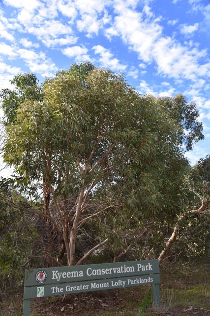
Some very wild and wet weather here in Adelaide has prevented a lot of portable activity.  Already this year Adelaide has well and truly exceeded its annual average rainfall.  And up here in the Mount Lofty Ranges ‘Adelaide Hills’ where I live it has been incredibly wet and windy, with lots of flooding.  But yesterday (Friday 29th July 2016) was a nice sunny afternoon, so I packed up the portable gear and headed down to the Kyeema Conservation Park VKFF-0826 and 5CP-107.

I have activated and qualified Kyeema previously, but my main reason for heading there was to book in to the newly formed VK Shires Net and hopefully hand out a new VK shire number to some of the participants.

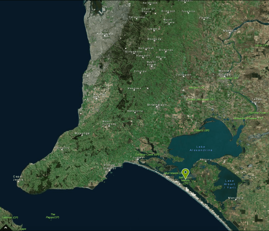
Kyeema is about 35 km south of my home, and around 62 km south of Adelaide.  It is situated on the Fleurieu Peninsula, south west of Meadows, and east of Willunga.

Screen Shot 2016-07-30 at 10.21.53 AM

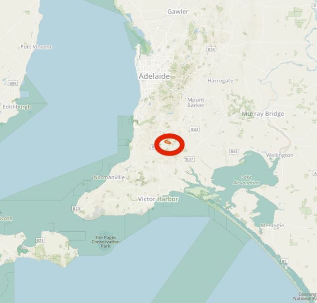
Above:- Map showing the location of the Kyeema Conservation Park, south of Adelaide.  Image courtesy of Protected Planet.

Previously I had activated the park from the southern side off Woodgate Hill Road, so this time after reviewing maps, I decided to try to access the park from the north.  It appeared after looking at maps, that there was a track which ran off Brookman Road and traversed through the northern section of Kyeema.

I travelled from home out through Echunga and on to Meadows.  I then took the Brookman Road, heading south towards Willunga.  I normally continue on to Woodgate Hill Road, but this time I kept an eye out for the track leading off to the east.  But sadly it appeared that the tracks I was viewing on maps, were tracks leading through Kuipto Forest which had locked gates from Brookman Road.  I reached Woodgate Hill Road and decided to turn around and head back to Brookman-Connor Road, hoping that somewhere from there I might find a track leading off to Kyeema.  Unfortunately I could not access the park from this side, as all the gates to the adjoining Kuipto pine forest were locked.

DSC_1480.jpg

So I contined on until I reached Blackfellows Creek Road, and commenced heading south.  It wasn’t long until I was able to see the north eastern corner of the park, across the cleared farming land.

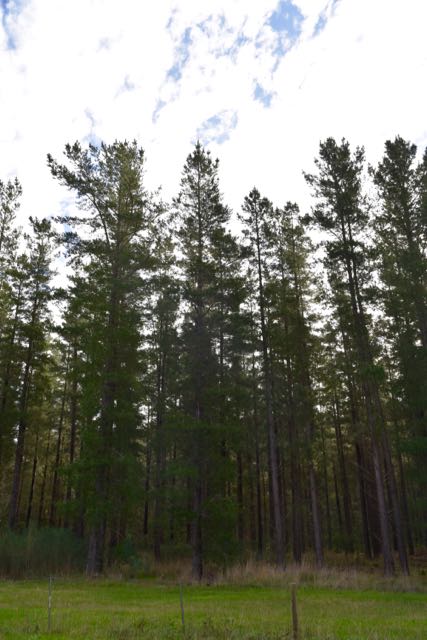
I then turned right onto Woodgate Hill Road and started travelling west towards the carpark, from where I normally set up.  This south eastern corner of the park is quite steep in terrain and it was very pleasing to see a lot of regrowth in the park after recent bushfires.

As I drove along Woodgate Hill Road, the Mount Magnificent Conservation Park and the summit soon come into view.  Sadly, the summit does not qualify for the Summits on the Air (SOTA) program, despite offering some amazing views from the top of the surrounding Fleurieu Peninsula.

DSC_1487

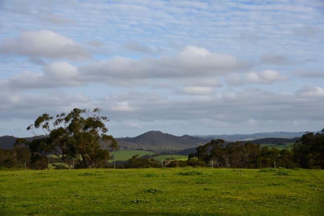
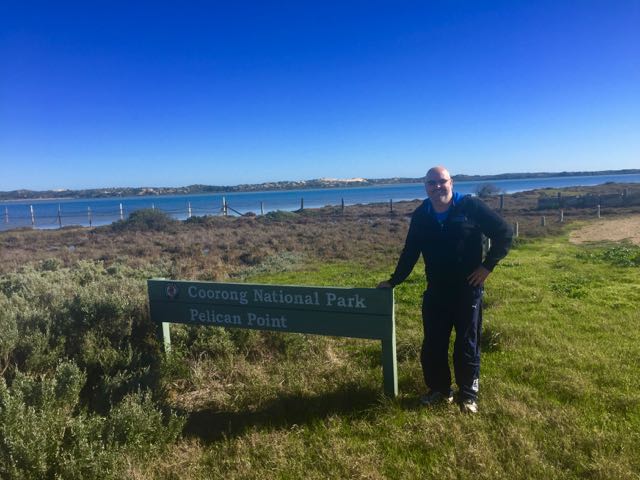
I soon reached the carpark on the northern side of the road.  There is plenty of room here for vehicles, and just to the west of the carpark is a cleared area, and this is where I set up.

DSC_1488.jpg

There is a cleared area between the western side of the carpark and the scrub and the far western boundary of the park.  It is an ideal spot to string out a dipole.  And as I had the larger 80/40/20m linked dipole with me today, this location was perfect.

Screen Shot 2016-07-30 at 10.21.16 AM

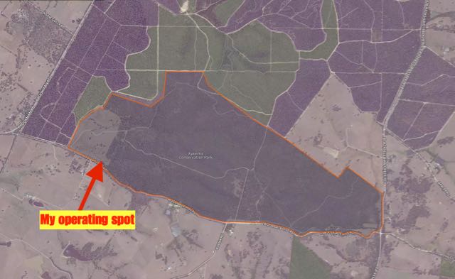
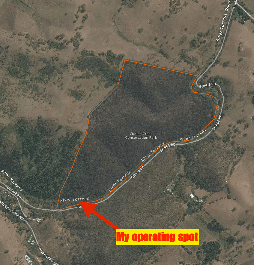
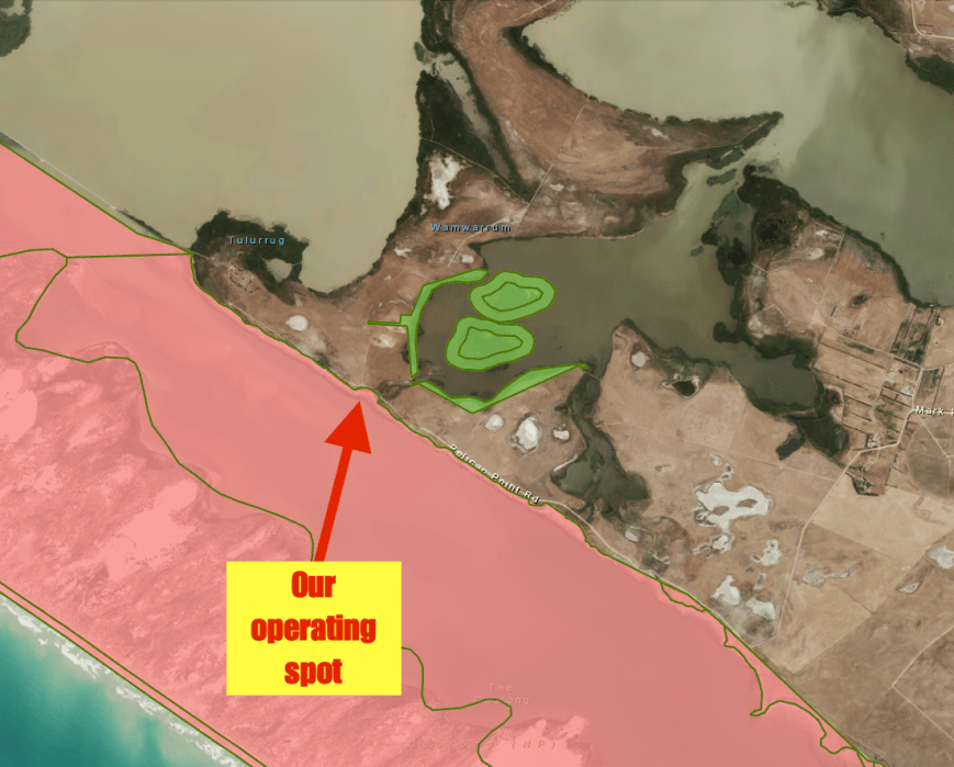
Above:- Aerial shot of the Kyeema Conservation Park, showing my operating spot in the south western corner of the park.  Image courtesy of Protected Planet.

Kyeema Conservation Park, which was first proclaimed on 1st January 1964,  is about 360 hectares in size.  An additional 25 hectares of land were added in 1974.  The park consists of thick scrub including messmate stringybark, pink gum, cup gum and canlebark gum.  The name Kyeema is believed to be local Kaurna aboriginal language meaning ‘dawn’.

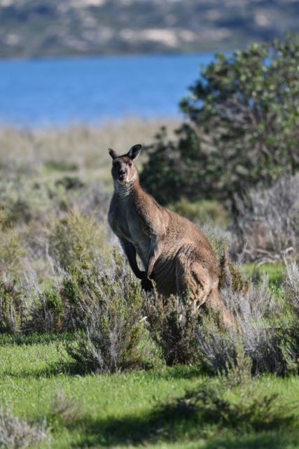
The park contains a large amount of native fauna including Western Grey kangaroos and the Southern Brown Bandicoot.  Around 88 species of birds can be found in the park.  Whilst I was there I spotted a number of Scarlet Robins.

This slideshow requires JavaScript.

The park was devastated during the 1983 Ash Wednesday bushfires, and a number of the eucalypt trees located in the south western part of the park were planted by school students during the 1980’s as part of a long-term revegetation program.  About 20,000 seedlings were planted in the first three years.  The area is known as the ‘Childrens Forest’ to recognise the many children who helped to re-create the valuable habitat.

Screen Shot 2016-07-30 at 1.03.14 PM.png

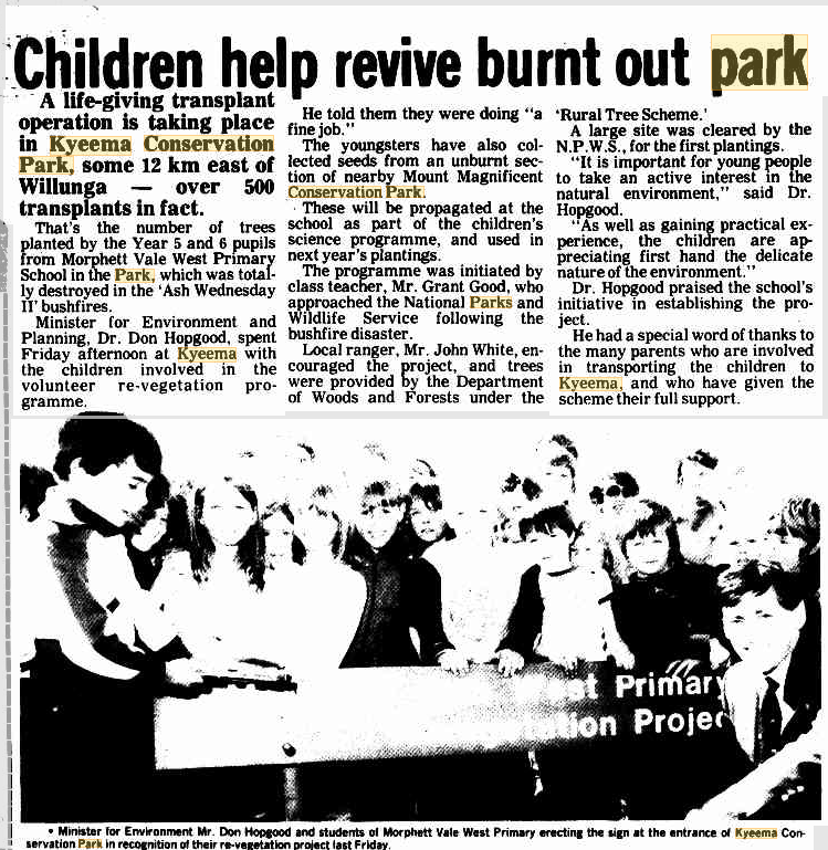
Above:- Article from the Victor Habour Times newspaper, Wednesday Sept 28 1983.  Courtesy of trove.nla.gov.au.

The park continues to have an active Friends of Kyeema Conservation Park group.

Kyeema Conservation Park has an extremely interesting history.  The area surrounding the park was mined for alluvial gold back in the 1880’s and was abandoned in 1890 due to a low yield.  A few years later, some the scrub was cleared for pine plantations and in 1932 a labour prison reserve was established here.  The camp which opened on 22nd March 1932 was South Australia’s first prison camp.  It was originally known as the Kyeema Afforestation Camp, and was later known as the Kyeema Prison Camp.  It was used by low security risk prisoners and on average, around 13 prisoners worked in the area at any one time, guarded by only 2 prison guards.  The prisoners cut a road through the stringybark forest to the camp, and sank wells, grew their own vegetables, carted water from the creek when the wells failed, showered from buckets, cut firewood, planted trees, put up fences and built bridges.   

The camp soon developed the reputation of being the most humane’ development in the history of the South Australian penal system’.  As was the case with other inmates a prison camps, the prisoners were called by name, not number, and were paid at a higher rate for their labours than other prisoners.  Upon completion of their work, the prisoners were allowed to yarn, read or play dominoes.  The prison camp was closed during the mid 1950’s.

I found some very interesting articles on Trove relating to the Camp.

I was on air by 0625 UTC, 5 minutes ahead of my posted activation time on parksnpeaks and Facebook.  I headed to 7.144 and asked if the frequency was in use and this was answered by Rick VK4RF/VK4HA who had a booming signal.  This was followed by Ken VK3UH, Mike VK6MB with a good 5/8 signal, and then Michael VK5FVSV.  The 40m band appeared to be in quite good shape, with good signals coming in from VK2, VK3, VK4, VK5, VK6, and VK7.  I also had a bit of QRM on the frequency with two other QSOs taking place.  I could hear a strong EA5 in Spain chatting away, and there was also a LU2 in Argentina.

About 18 contacts into the activation I was called by Rob VK4FFAB/p who was activating the Great Sandy National Park VKFF-0126.  Rob had an excellent 5/9 signal and reciprocated with a 5/9 for me.  A Park to Park contact is always a nice bonus during an activation.

I continued to work a steady flow of callers with good signals.  Hauke VK1HW almost blew me out of my chair with a huge 5/9 plus plus signal from Canberra.  It was nice to work Glenn VK2LDN who has recently upgraded from his Foundation call, and Eric VK7EV who has also upgraded from his F call.

I soon started to experience some very strong QRM from 7.146 and headed up there to find out who was there.  I politely asked if the 2 stations would mind QSYing a little higher up and they kindly obliged.  I then headed back to 7.144 and worked Les VK5KLV/p who was activating the Mount Brown Conservation Park VKFF-0914 and 5CP-145.  Les was extremely strong.  My last contact on 40m at this time was with Peter VK3PF and I left the frequency with Les VK5KLV.

I headed up to the VK Shires Net on 14.240, which was just starting to wrap up.  Sadly I just worked Lyn VK4SWE and Scott W5/MM0LID.  When the net wrapped up I headed off to 7.185 and the 40m version of the VK Shires Net which was being run by Bill VK4FW.  I logged Bill, Glen VK2FQSL, and Chris VK3QB.  Sadly there weren’t too many participants in the net.

I then went back to 7.144 and called CQ and worked William VK2NWB, Gerard VK2IO, Russell VK4ARW, Phil VK6ADF mobile and finally Roald VK1MTS mobile.  Both Phil and Roald had beautiful strong signals.

To conclude the activation I went to 80m and worked 5 stations on 3.610.  Michael VK5FVSV was first, followed by Mick VK3PMG/VK3GGG, followed by William VK2NWB and finally Gary VK5FGAZ.  Despite the signals being extremely good, I had very few callers.

The following stations were worked on 40m SSB:-

  1. VK4RF
  2. VK4HA
  3. VK3UH
  4. VK6MB
  5. VK5FVSV
  6. VK3OHM
  7. VK5BJE
  8. VK7CW
  9. VK7HT
  10. VK4AAC/3
  11. VK3BBB
  12. VK3GGG
  13. VK3PMG
  14. VK1MA
  15. VK2NNN
  16. VK3FSPG
  17. VK3MCK
  18. VK4FFAB/p (Great Sandy National Park VKFF-0126)
  19. VK5FANA
  20. VK6JON/7
  21. VK3FLCS
  22. VK5GJ
  23. VK7DW
  24. VK1HW
  25. VK4HNS
  26. VK2LDB
  27. VK3DBP
  28. VK2FSAV
  29. VK7EV
  30. VK5KLV/p (Mount Brown Conservation Park VKFF-0914 and 5CP-145)
  31. VK3PF
  32. VK4FW
  33. VK2FQSL
  34. VK3QB
  35. VK2NWB
  36. VK2IO
  37. VK4ARW
  38. VK6ADF/m
  39. VK1MTS/m

The following stations were worked on 20m SSB:-

  1. VK4SWE
  2. W5/MM0LID

The following stations were worked on 80m SSB:-

  1. VK5FVSV
  2. VK3PMG
  3. VK3GGG
  4. VK2NWB
  5. VK5FGAZ


References.

Birds SA, 2016, <http://www.birdssa.asn.au/location/kyeema-conservation-park/&gt;, viewed 30th July 2016.

Government of South Australia, 2016, ‘Thirty years for Friends of Kyeema’.

National Parks South Australia, 2016, <http://www.environment.sa.gov.au/parks/Find_a_Park/Browse_by_region/Fleurieu_Peninsula/kyeema-conservation-park&gt;, viewed 30th July 2016

Taylor; B, 2010, ‘Prisons without Walls: Prison Camps and Penal Change in Australia, c. 1013-c. 1975’.

Weekend Notes, 2016, <http://www.weekendnotes.com/hidden-secrets-battunga-country/?wns=2&gt;, viewed 30th July 2016


Cudlee Creek Conservation Park VKFF-1023 and 5CP-050

We had been forecast some very average weather today (Saturday 23rd July 2016), but fortunately it held off nicely for me to head out to the Cudlee Creek Conservation Park VKFF-1023 and 5CP-050.  The last time I had been to this park was way back in July 2013, so this was to be a unique park activation for me for the World Wide Flora Fauna (WWFF) program.

Screen Shot 2016-07-23 at 5.03.48 PM.png

Above:- Map showing the location of the Cudlee Creek Conservation Park.  Image courtesy of Protected Planet.

The park is situated just to the east of the little town of Cudlee Creek in the Mount Lofty Ranges ‘Adelaide Hills’, about 33 km north east of Adelaide.  The name Cudlee Creek is believed to be local aboriginal for Dingo’s Creek or wild dog crossing.  The first European inhabitants of Cudlee Creek settled in the area in 1838, just 2 years after the settlement of the State of South Australia.  William Kelly, from the Isle of Man, settled in the area and established the Sulby Glen Estate which was well know for its cheese making.  Cudlee Creek also became an exporter of fruit, in particular apples and pears.  A coldstore and packing shed was built in the town in 1922.

Today the population of Cudlee Creek is around 450 people.  The Gorge Wildlife Park, one of the largest privately owned animal parks in Australia is located at Cudlee Creek.  The old icecreamery in Cudlee Creek has now been converted into a cafe/restaurant and this was very busy as I passed through the town.

The River Torrens passes through the town.  The Torrens is the most significant river of the Adelaide Plains and was one of the reasons Adelaide was sited where it is today.  It flows about 85 km through the Adelaide Hills to its mouth between Henley Beach and West Beach.  The historic Union bridge crosses the Torrens at Cudlee Creek.  The original timber bridge was built in 1871 and was known as ‘Ledgards Bridge, and in 1917 was replaced with the current steel and concrete arched bridge.


The Cudlee Creek Conservation Park was proclaimed in 1971 and is home to a variety of native birds and animals who live in the woodlands on the steep hillsides.  Native animals that are found in the park include Western Grey kangaroos, and echidnas.  The River Torrens passes through the park on its southern border and after the recent rain was flowing very well.

Access to the park is limited.  There is no access to the north of the park.  I first approached the park from its western side (from Cudlee Creek township).  There is a small parking area near the park’s sign, so you can get your vehicle off Gorge Road.

DSC_1460

But I decided to continue east on Gorge Road towards North East Road, hoping that I would find another possible operating spot.  At the north eastern corner of the park I saw a small cleared area with a track leading down towards the river.  I was a bit confused as my GPS was showing that this was inside of the park, but there was a ‘Keep Out’ sign here.  I saw a 4WD ute parked down near the river so I drove down the track and found a fella down on the banks of the river.  As it turned out he was panning/screening for gold.  I asked him if he was the owner or if he knew that this area was private property.  He replied that he wasn’t the owner but that he believed it was private property as the owner had told him and his friends to leave on previous occasions.  I decided it wasn’t worth staying in this spot, and headed back towards the parking area further back along Gorge Road.

DSC_1466

The Cudlee Creek Conservation Park was devastated during the Sampson Flat bushfire in January 2015.  The fire destroyed 27 houses and burnt more than 20,000 hectares (49,000 acres) of land.  The park was closed for a significant period of time following the fire.  I was very pleased to see that although there were still visible signs of the fire, much of the bush had started to regenerate.

I set up in the south western corner of the park just off Gorge Road.  This was a picturesque spot and overlooked the River Torrens.  I used the park sign to secure the 7 metre squid pole, with the assistance of the always handy octopus straps.  I set up and deck chair, fold up table and Yaesu FT-857d and got to work.

Screen Shot 2016-07-23 at 5.02.18 PM.png

Above:- Map showing the location of my operating spot in the Cudlee Creek Conservation Park.  Image courtesy of Protected Planet.

I was set and up and ready to go by just after 0400 UTC (1.30 p.m.) which was the time I had posted on parksnpeaks and Facebook as my starting time in the park.  I headed to 7.144 and asked if the frequency was in use and the familiar voice of Dennis VK2HHA came back to let me know it was clear.  So Dennis was my first contact, followed by Marc VK3OHM, Greg VK5GJ at Meadows running just 4 watts, and then Damien VK5FDEC at Elizabeth running 5 watts.

Band conditions on 40m appeared to be quite good but it was noticeable that there were not as many callers as I’ve experienced during recent activations.  Conditions must have been good as I made contact again with Mike VK6MB in the middle of the day on 40m.  Although the busy Gorge Road was in close proximity to my operating spot, traffic was fairly light and it was fairly quiet.  All except for the occasional ‘weekend warrior’ on their motorcycle.  The Gorge Road is notorious for motorcycle riders and there have been a number of fatalities on Gorge Road over the years.  Not surprising when you see how some of these guys ride along that section of road.

After working a total of 43 stations on 40m from VK1, VK2, VK3, VK5, VK6, and VK7, I headed over to 20m.  This included a Park to Park contact with Neil VK4HNS who was operating portable in theBorder Ranges National Park VKFF-0047.  I first checked out the ANZA DX Net on 14.183 and was very concerned to hear signals very low down.  John VK4LJ who normally pounds in was extremely low.  So I headed up to 14.310 and started calling CQ and this was answered by Rick VK4RF/VK4HA, followed by Mike VK6MB.  But that was it for callers on 20m.  So it was down with the 40m/20m linked dipole and up with the 15m dipole.

I called CQ on 15m on 21.244 and this was answered by Mike VK6MB.  Despite the fact that signals were quite good (5/7 both ways), Mike was my only contact on 15m despite numerous CQ calls and a self spot on parksnpeaks.

The weather was moving in rapidly from the west and I was getting a few drops of rain, so it was an opportune time to pack up and head home.  I was content with 47 contacts in the log and another unique park qualified.

The following stations were worked on 40m SSB:-

  1. VK2HHA
  2. VK3OHM
  3. VK5GJ (QRP)
  4. VK5FDEC (QRP)
  5. VK3GGG
  6. VK3PMG
  7. VK3SIM
  8. VK3TKK
  9. VK5BJE
  10. VK3IO
  11. VK3GYH
  12. VK4AAC/3
  13. VK5KLV
  14. VK7CW
  15. VK6MB
  16. VK5TN
  17. VK3MCK
  18. VK5FMID
  19. VK2IO
  20. VK5ZEA
  21. VK2IF
  22. VK3BL
  23. VK3ZPF
  24. VK5FANA/m
  25. VK2YK
  26. VK3ANL
  27. VK3ELH
  28. VK5FD
  29. VK3FIRM
  30. VK2KYO
  31. VK4CPS
  32. VK5FAKV
  33. VK3PF
  34. VK1DI
  35. VK2PKT
  36. VK4HNS/2 (Border Ranges National Park VKFF-0047)
  37. VK2EXA
  38. VK3MRH
  39. VK6JON/7
  40. VK4FAAS
  41. VK3FPSR
  42. VK3KRH
  43. VK3NE

The following stations were worked on 20m SSB:-

  1. VK4RF
  2. VK4HA
  3. VK6MB

The following stations were worked on 15m SSB:-

  1. VK6MB


References.

Wikipedia, 2016, <https://en.wikipedia.org/wiki/Cudlee_Creek&gt;, viewed 17th July 2016

Wikipedia, 2016, <https://en.wikipedia.org/wiki/2015_Sampson_Flat_bushfires&gt;, viewed 17th July 2016

Weekend Notes, 2016, <http://www.weekendnotes.com/cudlee-creek-walk/&gt;, viewed 17th July 2016

The Gummeracha & District History Centre Inc, <http://www.gumeracha.com.au/otherPages/history/&gt;, viewed 17th July 2016


Talk at Elizabeth ARC

Last Wednesday night (2oth July 2016) I headed out to the Elizabeth Amateur Radio Club and delivered a presentation on operating portable, with specific content relating to the World Wide Flora Fauna (WWFF) program and the VK5 National & Conservation Parks Award.

Other than ‘death by powerpoint’, I had a number of transceivers, antennas, power sources, and other gear on display.

I will be heading back there in coming months to deliver a presentation on the WIA.

Thanks to the Elizabeth ARC for the invite.


Mowantjie Willauwar Conservation Park 5CP-152 and VKFF-0919 and the Trans Taman

On the way home from the Coorong I talked Marija into a quick stop off at the Mowantjie Willauwar Conservation Park, 5CP-152 and VKFF-0919.  The reason for the inpromptu activation was to spend an hour or two competing in the Trans Tasman Low Band Contest.  The contest has an aim to encourage Low Band activity trans Tasman, that is between VK and ZL, on the 160, 80 and 40m bands.

Mowantjie Willauwar Conservation Park was proclaimed on the 2nd June 2005, and conserves nearly 143 hectares of Southern Cyprus Pine Forest.  It is situated about 6 km south west of Tailem Bend.  Mowantjie is the aboriginal name for the native pine found in the park, while Willauwar is a plural word meaning ‘forest of species’.  Therefore the name Mowantjie Willauwar means ‘Native Pine Forest’, and this is a very accurate description of the park.  The park was originally known as the Tailem Bend Forest and still appears on Google maps as such.

I set up for around 90 minutes in the park and made a total of 90 contacts with 28 of those being on 40m SSB and 62 on 80m SSB.

For this activation I ran the Yaesu FT-857d, 40 watts and a 20m/40m/80m linked dipole which I supported with the 7m heavy duty squid pole.

This park always seems to be frequented by very hungry mosquitos and that combined with the freezing temperatures of just 1 degree C, did not persuade me to stay any longer than the 90 minutes.

Thanks to everyone who called.  I even picked up another two Park to Park contacts….with Gerard VK2IO in Dharug National Park VKFF-0139 and Marcus VK5WTF in Morialta Conservation Park 5CP-142 and VKFF-0783.

I contacted the following stations on 40m SSB:-

  1. ZL3VZ
  2. VK2ACH/p
  3. VK2PX
  4. VK2IO/p (VKFF-0139)
  5. VK2DEK
  6. VK6WE
  7. VK2ACD
  8. VK2MRX
  9. VK2ZK
  10. VK2HPN
  11. VK2BOB
  12. VK2SK
  13. ZM1W
  14. VK6DW
  15. VK7VH
  16. VK2MOR
  17. VK2AWX
  18. ZL2GD
  19. VK2ATZ
  20. VK6TKR
  21. ZL2CE
  22. VK4BZ/2
  23. VK6VCK/m
  24. VK2ZMT
  25. VK5FUZZ
  26. ZL1NAY
  27. VK2EFM
  28. ZL1YE

I contacted the following stations on 80m SSB:-

  1. VK2MT
  2. VK3XV
  3. VK3MBW
  4. VK4RF
  5. VK4HA
  6. VK5AW
  7. VK3PF
  8. VK3YE
  9. VK3ERA
  10. VK5CV
  11. VK2FAIB
  12. VK5NM
  13. VK2LDN
  14. VK7VAZ
  15. VK5SFA
  16. VK3TWO
  17. VK7GG
  18. VK3BF
  19. VK3HSB
  20. VK3LSD
  21. VK2PX
  22. VK7XDM
  23. VK5WTF/p (VKFF-0783)
  24. VK6FMON/3
  25. VK3PMG
  26. VK3GGG
  27. VK5BJE
  28. VK5CZ
  29. VK3ALB
  30. VK3PMG
  31. VK3GGG
  32. VK3UH
  33. VK2HPN
  34. VK2PX
  35. VK4FAAS
  36. VK4ICE
  37. VK4BZ/2
  38. VK3PF
  39. VK6POP
  40. VK2IG
  41. ZL1AAW
  42. VK3ERA
  43. VK6AS
  44. VK2ZK
  45. VK7VH
  46. VK3XV
  47. VK7PAL
  48. VK3YE
  49. VK2IO/p (VKFF-0139)
  50. VK3HAK
  51. VK5ST
  52. VK3ANL
  53. VK5FANA
  54. VK3BF
  55. VK5MCB
  56. VK3MBW
  57. VK4SN
  58. VK3GK
  59. VK2WG
  60. VK4FW
  61. VK2ATZ
  62. VK2EFM

Coorong National Park 5NP-005 and VKFF-0115

Yesterday (Saturday 16th July 2016), my wife Marija VK5FMAZ, and I headed down to the Coorong with the intention of activating a brand new park, the Salt Lagoon Islands Conservation Park, 5CP-203 and VKFF-1092.  However we were not entirely sure that we could gain access to the park, so our fall back plan was the adjacent Coorong National Park 5NP-005 and VKFF-0115.  Aerial maps showed a track towards the end of Pelican Point Road but we were not sure what we would encounter there.  A gate perhaps?  Information on the internet was less than helpful with regards to this park.

Screen Shot 2016-07-17 at 7.01.33 PM.png

Above:- Map showing the location of the Salt Lagoon Islands Conservation Park.  Image courtesy of Location SA Map Viewer.

Rather than travelling down the South Eastern Freeway to Murray Bridge and Tailem Bend, Marija and I drove down through the beautiful wine growing region of Langhorne Creek and then on to Wellington which is situated on the Murray River.  Wellington is just upstream of the Murray where it empties into Lake Alexandrina.  Wellington was the original crossing of the Murray River for people, livestock, and goods travelling overland between Adelaide and Melbourne, until a bridge was built at Murray Bridge in 1879.  But there are no such luxuries of a bridge at Wellington.  We boarded the ferry here and travelled across the river.

DSC_1322

Above:- Crossing the Murray River at Wellington.

After crossing the mighty Murray River we continued south on the Princes Highway until we reached Pottaloch Road and headed towards Port Malcolm.  The Pottaloch Road follows the southern boundary of Lake Alexandrina, which is a large freshwater lake comprising 1,061,469 km2.  The lake was named after Princess Alexandrina, the niece and successor of King William IV of Great Britain and Ireland.  We stopped for a short look at the Port Malcolm lighthouse, also known as Mundoo Light.  It is Australia’s only inland light station, with the concrete tower also being Australia’s smallest lighthouse.  The lighthouse operated between 1878 and 1931 to mark the narrow passage between Lake Albert and Lake Alexandrina.

We then crossed the ferry at Port Malcolm and on to Narrung which is located at the northern end of the Narrung Peninsula, which separates The Coorong from Lake Albert, adjacent to The Narrows, which separates Lake Albert from the larger Lake Alexandrina.  Lake Albert was named after Prince Albert, the Consort of Queen Victoria, by the South Australian Governor, George Gawler.

Narrung is a tiny place with a population of only around 275 people.  A little further on is the small settlement of Raukkan which is an indigenous aboriginal community.  It is the birthplace of David Unaipon, the inventor and author, whose image appears on the $50.00 note.

DSC_1354.jpg

We left Narrung and drove south along Loveday Bay Road, and it wasn’t long before the impressive sand dunes of the Coorong soon came in to view.

DSC_1358.jpg

We then drove north west along Pelican Point Road, with the impressive Coorong to our left.  In the distance we could see a trig point situated on one of the high points on the northern side of Pelican Point Road.  But alas, no SOTA summit here!

DSC_1396.jpg

We kept our eyes peeled for a possible entrance to the Salt Lagoon Islands Conservation Park, and soon came across the track we believed we had spotted on the maps.  Sadly there as a gate here.  And although it was not locked and there were no signs, I wasn’t prepared to enter until I had confirmed that I could legally do so.  We did bump into some Fisheries officers, but sadly they had no local knowledge of the park.  We also tried calling the after hours number for the Department of Environment Water and Natural Resources (DEWNR) but they were also unable to assist.

IMG_2532

So it was time to implement Plan B, the Coorong National Park.  The Coorong is a lagoon ecosystem and is an amazing place.  It was alive with various waterbirds as you can see from the photographs below.

This slideshow requires JavaScript.

We even came across this guy, a Western Grey kangaroo.  Emus are also often seen in the park, but we didn’t sight any of those on this occasion.

DSC_1384

Prior to setting up we drove to the end of Pelican Point Road to Pelican Point itself.  You cannot travel any further from this point.  There is a locked gate which takes you on to Tauwitchere Barrage and Ewe Island Barrage.  The main purpose of the barrages is to maintain the freshness of the River Murray as far downstream as Wellington.

IMG_2523.jpg

The name Coorong is believed to be a corruption of the local Aboriginal word kurangh, meaning “long neck”; a reference to the shape of the lagoon system.  The name is also thought to be from the Aboriginal word Coorang, “sand dune”, a reference to the sand dunes that form the Younghusband Peninsula which separates the Coorong from Encounter Bay in the Southern Ocean.  The park is 467 km2 and was established in 1966 as a sanctuary for numerous bird species.

We set up just opposite the Salt Lagoon Islands Conservation Park.  It was very frustrating being that close, but not close enough.  We set up the fold up table and deck chair just a few metres from the water, and used the Yaesu FT-857d and the 40m/20m linked dipole for the activation.

Screen Shot 2016-07-16 at 8.25.07 AM.png

Above:- Map showing our operating spot.  The green highlighted area is the Salt Lagoon Islands CP.  The pink highlighted area is the Coorong NP.  Map courtesy of Location SA Map Viewer.

As I had been to the Coorong many times before and well and truly qualified the park, Marija started off first.  The first contact in the log was with Rob VK4AAC/3 who was portable in the Mitchell River National Park VKFF-0321.  Marija then headed to 7.144 and commenced to call CQ and this was answered by Col VK5HCF in Mount Gambier with a beautiful 5/9 signal.  This was followed by Dennis VK2HHA, Mick VK3GGG, and then Les VK5KLV.  It wasn’t long before Marija had a little pile up going, and considering she is a brand new ham, I thought she did a splendid job.  The band was in very good shape and it wasn’t long before Marija had qualified the park with 44 contacts.

This included a Park to Park contact with Adam VK2YK who was portable in the Arakoon National Park VKFF-0578 and then later Hat Head National Park VKFF-0230, and also Gerard VK2IO who was portable in the Dharug National Park VKFF-0139.  This was the very first time that Dharug had been activated.

After Marija had fulfilled her quota, I jumped on to 40m, but my voice was far less appealing, and I scraped up 16 hunters on 40m.  I then headed to 20m and called CQ on 14.310 and this was answered by Mr. Reliable, Rick VK4RF/VK4HA.  This was followed by Greg VK8GM.  Greg and Rick kindly spotted me on the DX Cluster, parksnpeaks, and Facebook, and this no doubt resulted in a few calls from Europe.  But it was 4.00 p.m. local time and I think we had left our run on 20m a little too late.  I did manage to work Scott MM0LID in Scotland, Danny ON4VT and Luc ON4BB in Belgium.  Along with Martin VK6RC and John VK6NU.

I also tried my luck on 21.250 on 15m, but did not get any takers to my 5 minutes of CQ calls and a self spot on parksnpeaks.

Despite the fact that we could not gain access to Salt Lagoon Islands Conservation Park, it had been a beautiful Saturday afternoon out in the sun, on the banks of the Coorong lagoon.  There was not a cloud in the sky and we were blessed with moon which was shining brightly in the afternoon sky.

DSC_1422.jpg

The sun was starting to set so we packed up and headed back towards Narrung.

After crossing the ferry at Narrung, we took some time out to enjoy the sunset and the amazing views across Lake Alexandrina.  We could see the Mount Barker summit off in the distance (we live close to the summit).

Marija ended up with a total of 46 contacts on 40m.

I made a total of 25 contacts.

I worked the following stations on 40m SSB:-

  1. VK4AAC/3 (VKFF-0321)
  2. VK2YK/p (VKFF-0578
  3. VK2YK/p (VKFF-0230)
  4. VK5MRT
  5. VK5HS
  6. VK3GGG
  7. VK3PMG
  8. VK2HHA
  9. VK3FOTO/m
  10. VK5KLV
  11. VK4RF
  12. VK4HA
  13. VK2CX
  14. VK3MCX
  15. VK3FADM
  16. VK2KYO

I worked the following stations on 20m SSB:-

  1. VK4RF
  2. VK4HA
  3. VK8GM
  4. MM0LID
  5. ON4VT
  6. VK4SMA
  7. ON4BB
  8. VK6RC
  9. VK6NU


References.

Wikipedia, 2016, <https://en.wikipedia.org/wiki/Coorong_National_Park&gt;, viewed 17th July 2016

What is the CAPAD?

For the World WideFlora Fauna (WWFF) program, one of my main references for researching parks is the CAPAD data.  I’ve been asked quite a bit, ‘What is the CAPAD?’  So here’s a little bit of information explaining what it is all about.

What is the CAPAD?

The Collaborative Australian Protected Areas Database (CAPAD) , released by the Department of the Environment, Australian Government, provides both spatial and text information about government, indigenous and privately protected areas for continental Australia.   State and Territory conservation agencies supply data and this in turn is compiled and published in the CAPAD.  The ninth version of the CAPAD database was released in 2014, with previous versions released in 1997, 2000, 2002, 2004, 2006, 2008, 2010 and 2012.

logo

The Department also publishes protected areas data for the marine environment.  This  contains spatial and text information about offshore protected areas, for both State and Commonwealth waters.  The most recent version was released in 2014, with previous versions of CAPAD marine information having been published in 1997, 2002, 2004, 2008, 2010 and 2012.

Screen Shot 2016-07-14 at 8.30.27 AM.png

When and where can I find the CAPAD?

The department publishes a summary of the CAPAD data biennially on its website at http://www.environment.gov.au/capad/

What is spatial data?

Spatial data, also known as geospatial data or geographic information, is date or information that identifies the geographic location of features and boundaries on Earth, such as natural or constructed features, oceans, and more.  Spatial data is usually stored as coordinates and topology, and is data that can be mapped.

What is found in the CAPAD?

The CAPAD provides a snapshot of protected areas that meet the International Union for Conservation of Nature (IUCN) definition of a protected area:

“A protected area is an area of land and/or sea especially dedicated to the protection and maintenance of biological diversity, and of natural and associated cultural resources, and managed through legal or other effective means” (IUCN 1994).

CAPAD provides information at a national, state and territory level. For each grouping CAPAD includes information about the following:

  • List of all protected areas. This list includes information on IUCN category, location (latitude and longitude of mid-point (centroid)), area (hectares) and gazettal date (the year an area was declared a protected area).
  • Protected areas classified according to reservation type designations eg National Park, Conservation Covenant, Indigenous Protected Area.
  • Protected areas classified according to IUCN management categories eg. Number of designated Category III protected areas in NSW.
  • Protected areas classified according to type designations as a proportion of Australia’s bioregions (known as IBRA). For example, the number of type designations within the Victorian Midlands (VM) IBRA region in Victoria and the percentage of those types of Protected Areas within that region.
  • Protected areas classified according to IUCN management categories as a proportion of IBRA region eg. Number of Category II protected areas in Queensland and the percentage of those IUCN categories within the Queensland IBRA regions.
  • The level of protection of IBRA regions.
  • The level of protection of IBRA subregions.
  • Protected Areas classified according to governance e.g. government, joint, indigenous and private.

Screen Shot 2016-07-13 at 6.47.59 PM.png

IUCN Protected Areas Categories System

IUCN protected area management categories classify protected areas according to their management objectives. The categories are recognised by international bodies such as the United Nations and by many national governments as the global standard for defining and recording protected areas and as such are increasingly being incorporated into government legislation.

a Strict Nature Reserve: Category Ia are strictly protected areas set aside to protect biodiversity and also possibly geological/geomorphical features, where human visitation, use and impacts are strictly controlled and limited to ensure protection of the conservation values.

Ib Wilderness Area: Category Ib protected areas are usually large unmodified or slightly modified areas, retaining their natural character and influence without permanent or significant human habitation, which are protected and managed so as to preserve their natural condition.

Ib Wilderness Area: Category Ib protected areas are usually large unmodified or slightly modified areas, retaining their natural character and influence without permanent or significant human habitation, which are protected and managed so as to preserve their natural condition.

III Natural Monument or Feature: Category III protected areas are set aside to protect a specific natural monument, which can be a landform, sea mount, submarine cavern, geological feature such as a cave or even a living feature such as an ancient grove. They are generally quite small protected areas and often have high visitor value.

IV Habitat/Species Management Area: Category IV protected areas aim to protect particular species or habitats and management reflects this priority. Many Category IV protected areas will need regular, active interventions to address the requirements of particular species or to maintain habitats, but this is not a requirement of the category.

V Protected Landscape/ Seascape: A protected area where the interaction of people and nature over time has produced an area of distinct charcter with significant, ecological, biological, cultural and scenic value: and where safeguarding the integrity of this interaction is vital to protecting and sustaining the area and its associated nature conservation and other values.

VI Protected area with sustainable use of natural resources: Category VI protected areas conserve ecosystems and habitats together with associated cultural values and traditional natural resource management systems. They are generally large, with most of the area in a natural condition, where a proportion is under sustainable natural resource management and where low-level non-industrial use of natural resources compatible with nature conservation is seen as one of the main aims of the area.

What is IBRA?

The Interim Biographic Regionalisation for Australia (IBRA) was developed in 1993-94 and is endorsed by all levels of government as a key tool for identifying land for conservation.  The latest version, IBRA7, classifies Australia’s landscapes into 89 large geographically distinct bioregions based in common climate, geology, landform, native vegetation and species information, e.g. Australian Alps, the Nullabor Plain, the Wet Tropics, etc.
Screen Shot 2016-07-14 at 9.03.23 AM.png


References.

Australian Government, Department of the Environment, <https://www.environment.gov.au/land/nrs/science/capad/2014&gt;, viewed 13th July 016

International Union for Conservation of Nature, <http://www.iucn.org/theme/protected-areas/about/categories&gt;, viewed 13th July 2016