Yesterday morning (Saturday 30th April 2016) I travelled out to the Wiljani Conservation Park 5CP-274 and VKFF-1159, which is located just a few km north west of the town of Mount Pleasant. This was to be the very first activation of Wiljani CP. Bob VK5FO had sent me an email a week or 2 ago advising that he had stumbled across this park whilst surfing the web. I checked the South Australian Government Gazette and sure enough Wiljani had been gazetted as a Conservation Park on 25th February 2016.
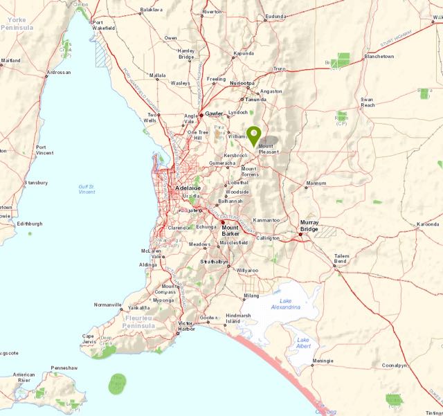
Above:- Map showing the location of the Wiljani Conservation Park, to the north west of Mount Pleasant in the Adelaide Hills. Image courtesy of Location SA Map Viewer.
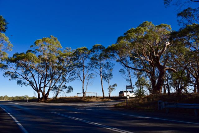
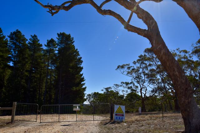
I headed out from home through Nairne and Woodside and then the little town of Charleston. I continued north east to the historic little village of Mount Torrens and then on to Birdwood, the home of the National Motor Museum. From Birdwood I took the Torrens Valley Road until I reached the town of Mount Pleasant. Just after entering the western side of Mount Pleasant I turned left onto Cricks Mill Road, and I soon reached the junction with Elliotts Boundary Road (photo below).
I then travelled north east along Elliotts Boundary Road, which is a dirt road. The road is in good condition and there are no problems for conventional vehicles. I followed the southern boundary of the Mount Crawford Pine Forest. It was quite slow going, as it was only 8.00 a.m. in the morning and there were quite a few kangaroos out and about.
I soon came to the south western corner of the park. There is a track here which follows the western boundary of the park. However, the track was inaccessible as there was a locked gate with a large sign stating that tree felling was in process.
The park does not currently have a Conservation Park sign erected. However there is a sign which states ‘Boundary Road Conservation Reserve’.
Wiljani was a family group of the Peramangk aboriginal people whose traditional lands are primarily located in the Adelaide Hills. The lands of the Tarrawatta and Yira-Ruka (Wiljani) extended to the east down as far as Mount Torrens and Mannum.

Above:- the lands of the Permangk aboriginal people. Image courtesy of Wikipedia.
This is a beautiful little piece of surviving Mount Lofty scrub and it is not surprising that it has been declared as a Conservation park. The land was previously set aside as Crown Land and was proclaimed as a Conservation Park due to its diversity of flora and fauna. The park was alive with Kookaburras and Superb Blue Wrens whilst I was there.
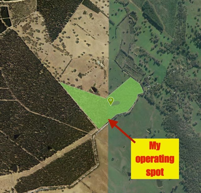
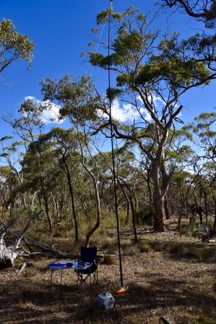
I drove to the end of Elliotts Boundary Road to check out my options for an operating spot. The north eastern side of the park is not able to be accessed, as the road following that side of the park is a private road leading to private property. The western side of the park was not accessible due to the locked gate, unless you are prepared to jump the gate and walk a bit. The easy option is the southern side of the park. However, there is a power line following part of the road, so I tried to find a spot away from the power line.
For this activation I used my normal operating station consisting of the Yaesu FT-857d, set at 40 watts output, and a 40m./20m linked dipole, and a 15, dipole.
After setting up I headed to 7.144 but found that the frequency was occupied by a station from the USA. I headed up the band but struggled to find a clear frequency as there were some strong European signals coming through. So I headed down the band and found 7.135 clear and commenced calling CQ. I put out about half a dozen CQ calls but had no takers, so I self spotted on parksnpeaks. The very first hunter for Wiljani was Les VK5KLV in Port Augusta with a very strong 5/9 + signal, followed by Bob VK5FO, then Geoff VK3SQ, and Peter VK3PF. It was very pleasing to get Bob in the log as he was the person who had advised me of the existence of the park.
I worked a total of 35 stations prior to the UTC rollover from VK1, VK2, VK3, and VK5. Contact number 10, qualifying the park for me for the VKFF program was Mick VK3GGG. After the UTC rollover I worked a total of 27 stations on 40m from VK2, VK3, VK4, VK5, and VK7. Contact number 44, qualifying the park for me for the global WWFF program was Neil VK4HNS.
After working a total of 62 stations on 40m, I lowered the squid pole and removed the links in the dipole and headed to 14.310 on 20m. My first taker there was Robert VK2XXM, followed by Cliff VK2NP and then Marty VK2RZ. I worked a total of 9 stations from VK2 and VK6.
I then took down the 40m/20m linked dipole and replaced it with the 15m dipole and commenced calling CQ on 21.244 after self spotting on parksnpeaks. Allen VK6XL was the first responder, and it was nice to get Allen in the log, after we had also spoken on 20m. Allen’s signal on 15m was an excellent 5/9 and he reciprocated with a 5/9 for me. Next up was Aki JA1CTB in Japan. I worked a further 3 stations from Japan: Kaz JR0WZR, Masa JE1CWQ, and Take JH1RFZ, and also Rick VK4FTRL. Interestingly I was spotted on the DX Cluster by YC9CT, but I did not receive a call from him.
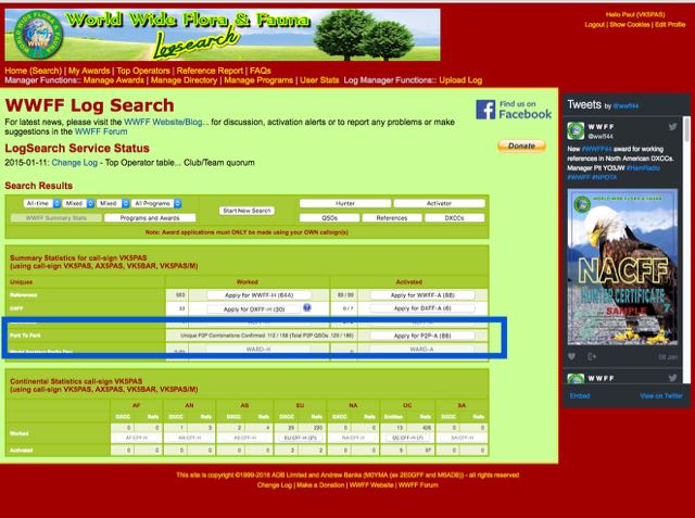
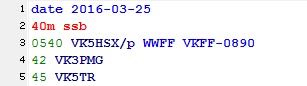
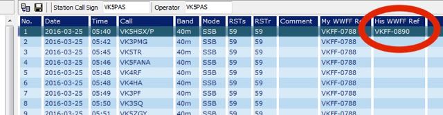
I headed back to 40m for around 30 minutes, and worked a total of 22 stations. This included a park to park contact with Stef VK5HSX who was portable in the Little Desert National Park, VKFF-0291, in western Victoria. Callers had slowed down for me so I handed the frequency over to Stef, and I had one last quick look around the band before going QRT. My final contact was with Tony VK7LTD who was operating portable on SOTA summit VK7/ SC-003.
It was time to head home and have some lunch. I was very pleased with a brand new park under my belt and a total of 101 contacts in the log. Thanks to everyone who called.
The following stations were worked on 40m SSB:-
- VK5KLV
- VK5FO
- VK3SQ
- VK3PF
- VK5QI
- VK2IO
- VK3ZPF
- VK2GAZ
- VK5HSX/p
- VK3GGG
- VK3PMG
- VK5GJ
- VK1MA
- VK3FPSR
- VK5FTVR
- VK3DAC
- VK2HHA
- VK3MCK
- VK3VIN
- VK5NAQ
- VK5HEL
- VK3ARH
- VK5ZGY
- VJ3FOWL
- VK5NFT/m
- VK5FMID
- VK2XXM
- VK2NP
- VK3MRH
- VK1DI
- VK5TN
- VK5FANA
- VK4FTAD
- VK5PL
- VK3FOTO/m
- VK3FSPG
- VK3MRG
- VK2NWB
- VK3VBI
- VK5FVSV
- VK3UH
- VK5FUZZ
- VK3FQSO
- VK4HNS/p
- VK5YX
- VK7CW
- VK3TKK/m
- VK3OE
- VK5AO
- VK5FTVR
- VK3LSD
- VK5NNT
- VK5SFA
- VK3ZMD
- VK5LDM
- VK7BC
- VK5WG
- VK5TRM
- VK3BBB
- VK3FAPH
- VK5FDEC
- VK3VCE/p
- VK2EJW
- VK3FMRC
- VK5BJE
- VK3SIM
- VK3CM
- VK5KLV
- VK3ELH
- VK3BNJ
- VK3TCT
- VK3VGB
- VK5FAKV
- VK5GJ
- VK3BWZ
- VK2LEE
- VK5KKR
- VK3TJK
- VK5FMLO
- VK3AZZ
- VK3MVP
- VK3YW
- VK5HYZ
- VK5HSX/3 (Little Desert National Park VKFF-0291)
- VK7LTD/p (SOTA VK7/ SC-003)
The following stations were worked on 20m SSB:-
- VK2XXM
- VK2NP
- VK2VCC
- VK6RZ
- VK2MZZ/m
- VK2MOR
- VK2HTM
- VK6XL
- VK2LKW
The following stations were worked on 15m SSB:-
- VK6XL
- JA1CTB
- JR0WZR
- JE1CWQ
- VK4FTRL
- JH1RFZ
References.
Wikipedia, 2016, <https://en.wikipedia.org/wiki/Peramangk>, viewed 1t May 2016