Koonda Nature Conservation Reserve VKFF-2349

Our second park for the day (Friday 9th November 2018) was the Koonda Nature Conservation Reserve VKFF-2349, which is about 43 km (by road) from Murrayville in north western Victoria.

Screen Shot 2018-11-12 at 10.06.20 pm.png

Above:- Map showing the location of the Koonda Nature Conservation Reserve in north western Victoria.  Map courtesy of Protected Planet.

After leaving the Manya Nature Conservation Reserve we drove back towards Murrayville.  We stopped off briefly to have a look at the site of the old Sunset State School at Panitya North, which operated between 1917 – 1943.

We then drove into Murrayville and went to the caravan park to pick up our cabin key.  We then headed out of Murrayville, on the Mallee Highway and soon reached the town of Cowangie.  The Post Office opened on 15 July 1912 when a regular mail service was provided by the opening of the railway from Ouyen to Murrayville a month earlier. Known as Kow Plains until 1913, the office closed in 1994.  The word ‘Kow is derived from an aboriginal word believed to mean ‘white clay or gypsum’.  The name Cowangie is thought to be derived from an aboriginal word meaning ‘fog or mist’.

Former Formula One and V8 Supercar driver Larry Perkins grew up in Cowangie.

DSC_3183

I was unable to locate much information about the Koonda NCR.  Koonda is 5.06 km2 in size and is a typical mallee park.  It is recorded on the Parks Victoria website as a Flora Reserve.  Koonda appears to be an aboriginal word meaning ‘bandicoot’.  The park is not to be confused with the area of Koonda, which is located near Upotipotpon, about 536 km to the south east of the park.

Marija and I access the park via Sunset Road off the Mallee Highway, and then Morrison Plain Road.  We could not find any signs for the park, but were guided in by our GPS.  It was a hot day, so we parked the car just off the road, and set up underneath the shade of some trees.

Screen Shot 2018-11-12 at 10.06.07 pm.png

Above:- Aerial view of the park showing our operating spot.  Image courtesy of Protected Planet.

I commenced the activation by calling CQ on 7.144.  As per our previous activation at Manya, we had no internet coverage, so we were unable to self spot on parksnpeaks.  First in the log was Alan VK3ALN/p, followed by Marc VK3OHM, Dennis VK2HHA, and Les VK5KLV.  All had good 5/8-9 signals.  I logged a total of 24 stations from VK1, VK2, VK3, VK4, and VK5.  This included Ade VK4SOE/p who was in the Sundown National Park VKFF-0471.  Marija and I then swapped the mic.

DSC_3188

Marija had soon achieved her 10 contacts to qualify the park for the VKFF program, with a QSO with Geoff VK3SQ.  Marija logged one further station, Adam VK2YK, before we decided to try our luck on the 80m band.  Marija logged 5 stations on 80m, including a Park to Park with Brett VK3FLCS/p in the Macedon Regional Park VKFF-0972.  I logged 5 stations also, including  a Park to Park with Brett.

To complete the activation I called CQ on 14.310, but did not get any takers.  Spotting is certainly a very important tool when activating parks.  I’m sure had we been spotted on parksnpeaks, I would have made contacts on 20m.  But sadly we had no internet coverage and were unable to throw up a self spot.

Marija and I had 45 contacts in the log between the 2 of us from the park, including 3 Park to Park contacts.  We will have to return here to get our 44 QSOs to qualify the park for the global WWFF program.

Marija worked the following stations on 40m SSB:-

  1. VK3PF/m
  2. VK5FANA
  3. VK7ZGK
  4. VK4NH
  5. VI4DXA
  6. ZL4TY/VK4
  7. VK2IO
  8. VK2MOR
  9. VK3ALN/p
  10. VK3SQ
  11. VK2YK

Marija worked the following stations on 80m SSB:-

  1. VK5BJE
  2. VK5HS/m
  3. VK3FLCS/p (Macedon Regional Park VKFF-0972)
  4. VK5FANA
  5. VK5FMWW

I worked the following stations on 40m SSB:-

  1. VK3ALN/p
  2. VK3OHM
  3. VK2HHA
  4. VK5KLV’
  5. VK3GZ
  6. VK3FDZE
  7. VK3SQ
  8. VK4SMA
  9. VK3NRG/p
  10. VK4NH
  11. VK4DXA
  12. ZL4TY/VK4
  13. VK2IO
  14. VK3TKK/m
  15. VK3CWF
  16. VK4TJ
  17. VK2NP
  18. VK2MOR
  19. VK4SOE/p (Sundown National Park VKFF-0471)
  20. VK3PF
  21. VK5FANA
  22. VK2YK
  23. VK1FMGG
  24. VK4ANB

I worked the following stations on 80m SSB:-

  1. VK3SQ
  2. VK5BJE
  3. VK5FMWW
  4. VK5FMLO
  5. VK3FLCS/p (Macedon Regional Park VKFF-0972)


References.

Dear Grandpa Pencil, 2018, <http://www.grandpapencil.net/austral/abword/abk.htm>, viewed 12th November 2018

Victorian Places, 2018, <https://www.victorianplaces.com.au/cowangie>, viewed 12th November 2018

Wikipedia, 2018, <https://en.wikipedia.org/wiki/Cowangie>, viewed 12th November 2018


Manya Nature Conservation Reserve VKFF-2377

Marija and I made a fairly early start on Friday morning (9th November 2018), after a 14 hour shift for me at work the night before.  We were on the road by about 8.00 a.m. and had around a 255 km trip ahead of us to Murrayville in north western Victoria.  We had booked in to the Murrayville caravan park for 2 nights.

We travelled along the South Eastern Freeway and over the Murray River at Murray Bridge and on to Tailem Bend along the Dukes Highway.  We turned off at Tailem Bend on to the Mallee Highway.  This is the way to get to Sydney.

DSC_3112

Our first stop for the day was the little town of Sherlock, about 32 km east of Tailem Bend.  The town was proclaimed on 8th August 1907, and is named after The Hundred of Sherlock, which was proclaimed in 1899 and named by Lieutenant-Governor Way after one of Governor Buxton’s friends..  The Sherlock School was opened in 1911 in the Baptist Church and closed in 1970.  This was the first stone building erected along the Pinnaroo railway line.  The Sherlock railway station was opened in January 1913.  It was a busy place, acting as a service point for the town of Karoonda and surrounds.

We travelled a short distance down the road and reached the town of Peake, which takes its name from the Hundred of Peake, named in honour of Archibald Henry Peake (1897-1920), three times Premier of South Australia.  Peake was proclaimed on 8th August 1907.  Its school opened in 1909 and closed in 1964.  The town was located along the railway line, and by 1909 the town was ‘the refreshment station and there was always a rush for the pie stall just along the line’.

There are a number of historic buildings in Peake, and there is a historic walk that can be undertaken.  A brochure entitled ‘Welcome to the historic settlement of Peake’ can be picked up in the town, and will guide you around the streets.

An interesting site to see here in Peake is Polly’s Well.  It was sunk in 1877 by John Whyte, an early pioneer of the district.  It was an important watering point, as in the early years of the district, there were no bituminised roads and air conditioned motor vehicles.  It took an average of 8 long days to travel between Tailem Bend and Pinnaroo by bullock wagon.

We continued east along the Mallee Highway, passing the little towns of Jabuk and Geranium, and then reached the town of Lameroo, which is about 40 km west of the State border.  The town is primarily a service town for the surrounding rural areas, growing grain and sheep.

DSC_3130

Above:- the Main Street of Lameroo.

In the late 1850’s land was taken up in the area on pastoral lease. The area was known as Wow Wow Plain back in those days.  A well was sunk in 1884.  The well measuring 7 feet by 4 feet in section, and 254 feet deep, served both locals and travellers with water for personal use and stock supplies.   The land was surveyed in 1894, and the initial survey of Wow Wow Plain gave each block some natural open land to start cultivating.  The town was named Lameroo in 1904 at the suggestion of J.M. Johnston who had worked on the Overland Telegraph Line and heard the word in Darwin, as the name of the Lameroo Beach.  He liked the sound of Lameroo, and the town was thus named.

We stopped off briefly to have a look at the site of the old Wow Wow Well.

We then drove out of town about 3 km to have a look at Byrne Homestead, an old pug and pine settlers hut built in 1898.

We continued on our journey along the Mallee Highway and soon reached the town of Pinnaroo.  The town’s name is derived from the Ngarkat aboriginal language wored ‘pinaru’, the tribal name for the district and many relate to Ngautngaut, an ancestral being who played a big role in the mythology of the Ngarkat people.

We took the time to have a look through the Pinnaroo Museum, which can be located at the Visitor Centre.  The museum contains an excellent display of printing presses, restored tractors and engines, and other memorabillia.  It is well worth a look.

Of course, I found a few radio related articles in the museum, including a morse key.

DSC_3147

And a range of early radios.  Very interesting.

This slideshow requires JavaScript.

Not long after leaving Pinnaroo, we reached the South Australia/Victoria State border.

DSC_3164

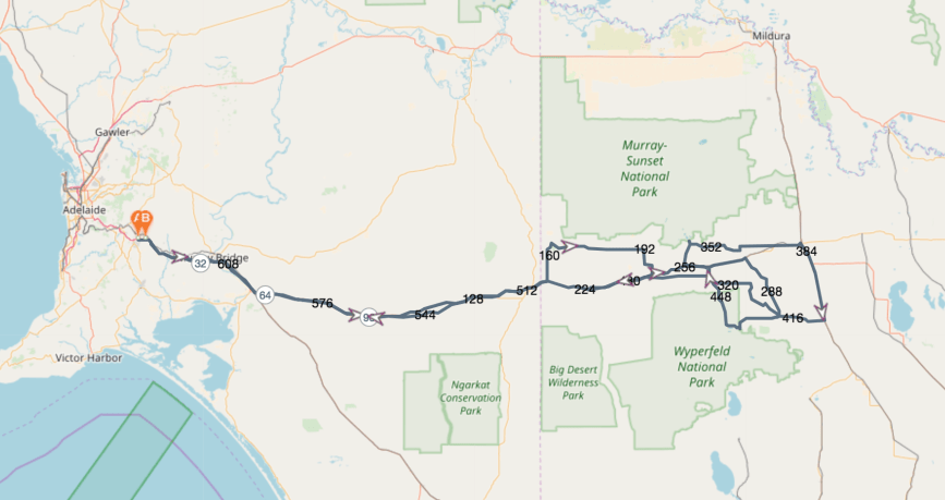
Our first planned park activation was the Manya Nature Conservation Reserve, VKFF-2377.

Screen Shot 2018-11-12 at 8.23.02 pm.png

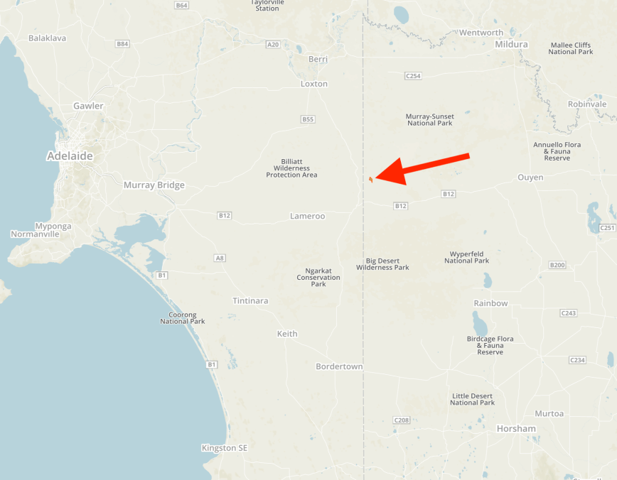
Above:- Map showing the location of the Manya Nature Conservation Reserve in north western Victoria.  Map courtesy of Protected Planet.

The Manya Nature Conservation Reserve is about 4.62 km2 in size and is a typical mallee park.  It is in close proximity to the South Australian/Victoria State border, about 9 km north of the town of Panitya in Victoria.  The place name Manya is derived from the local Aboriginal word meaning “the hand”.  The park is referred to in the 2016 CAPAD data as a Flora Reserve and Nature Conservation Reserve.  It is not to be confused with the Manya Bushland Reserve which is located to the north west of the park.

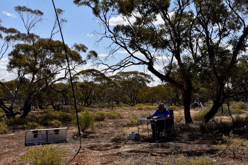
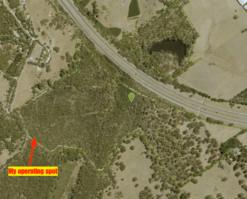
After crossing the State border, we travelled east to the little town of Panitya and then travelled north on the Panitya North Road.  The northern boundary of the park is located at the corner of Panitya North Road and Wheeler Road.  We found a track prior to this junction, which travelled into the park.  After travelling a few hundred metres along the track we found a cleared area, with just enough room to stretch out the linked dipole, but only just.

Screen Shot 2018-11-12 at 8.22.44 pm.png

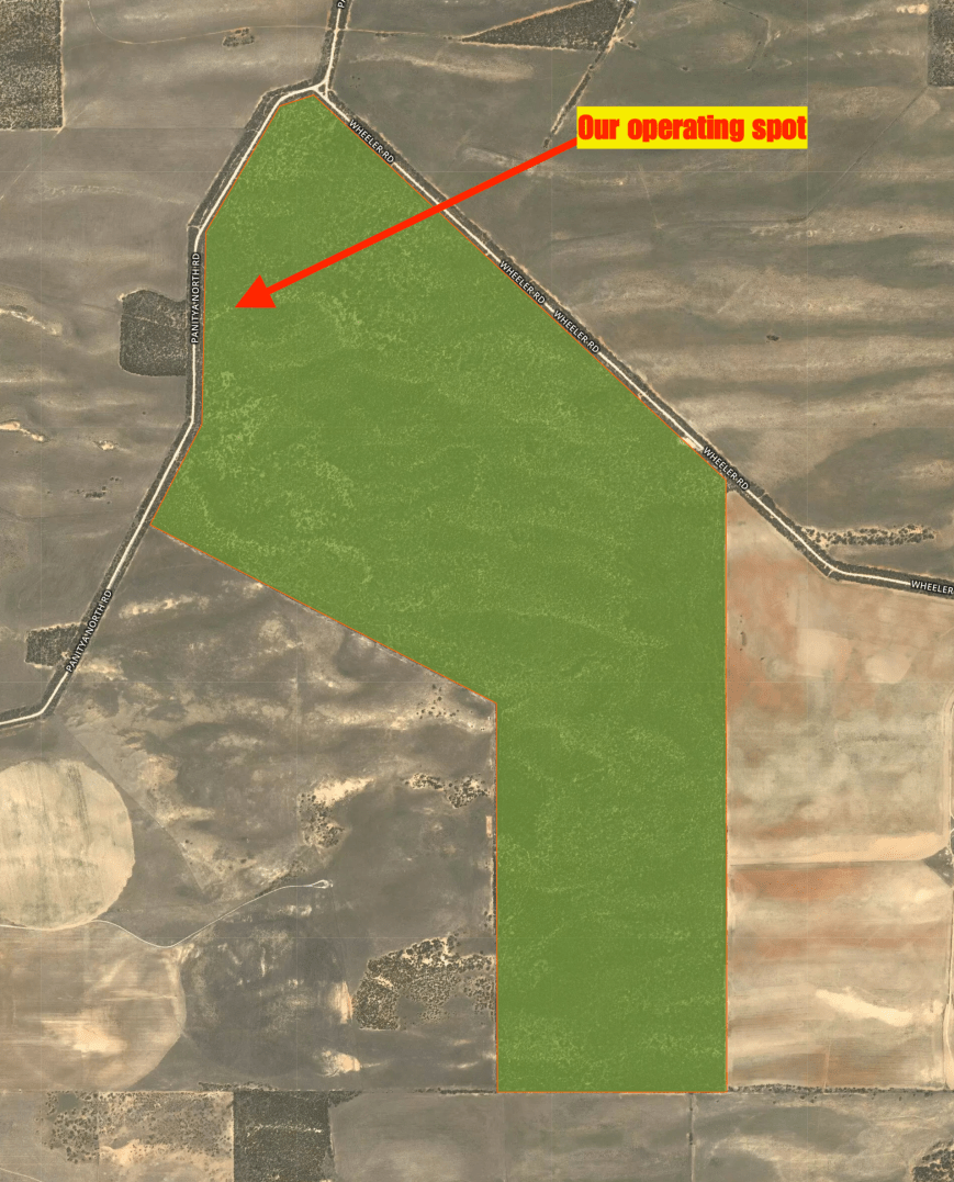
Above:- Aerial shot of the park showing our operating spot.  Image courtesy of Protected Planet.

On our way into the park we worked Tony (VK3XV) VK3WI/p from our mobile, who was activating the Brisbane Ranges National Park VKFF-0055.

We had no internet coverage in the park, so we were unable to self spot on parksnpeaks and/or Facebook.  After setting up, I kicked off the activation, with a Park to Park with Tony VK3WI/p.  Marija also logged Tony.  We then tuned across the band and logged Ade VK4SOE/p & VK4COA/p on 7.140, who was activating the Sundown National Park VKFF-0471.  We then moved down to 7.135 and I started calling CQ.  First in the log there was Peter VK3PF, followed by Peter VK3TKK/p who was in the Dandenong Ranges National Park VKFF-0132.

I had planned on just getting my 10 contacts to qualify the park for the VKFF program, and not sticking around to get 44 QSOs.  We had hoped to activate 3 more parks, so we were a bit pressed for time.  It was quite slow going, but after about 20 minutes, I had contact number 10 in the log.  I logged 15 stations before swapping the mic with Marija.   My contacts were into VK2, VK3, VK4, and VK5, and included Tony VK5TT who was pedestrian mobile walking his dog and operating remote, and David VK5PL/p who was in the Wiljani Conservation Park VKFF-1159.

Marija was also keen to get her 10 and for us to move on.  Marija called CQ and this was answered by Peter VK3PF, followed by Allan VK3ALN/p and then Geoff VK3SQ.  Marija logged a total of 13 stations from VK2, VK3, VK5 and VK7.

We then moved down to 80m and Marija called CQ on 3.610.  First in the log was John VK5BJE who was an excellent 5/9 signal, followed by David VK5PL in the WIljani Conservation Park, and then Tony VK3WI mobile.

To complete the activation I called CQ on 14.310, but was competing with the Over the Horizon Radar which was very loud.  I logged Ray VK4NH and then Michael VK6TU.  But the radar had become too annoying, so I headed down to 14.260 and called CQ which was answered by Andrei ZL1TM, and then Neil VK4HNS.

Marija and I had 38 contacts in the log between us, along with

Marija worked the following stations on 40m SSB:-

  1. VK3WI/p (Brisbane Ranges National Park VKFF-0055)
  2. VK4SOE/p (Sundown National Park VKFF-0471)
  3. VK4COA/p (Sundown National Park VKFF-0471)
  4. VK3PF
  5. VK3KAI
  6. VK3ALN/p
  7. VK3SQ
  8. VK5KLV
  9. VK3ANL
  10. VK7EK
  11. VK2VN
  12. VK5TT/p
  13. VK3AAT/p

Marija worked the following stations on 80m SSB:-

  1. VK5BJE
  2. VK5PL/p (Wiljani Conservation Park VKFF-1159)
  3. VK3WI/m

I worked the following stations on 40m SSB:-

  1. VK3WI/p (Brisbane Ranges National Park VKFF-0055)
  2. VK4SOE/p (Sundown National Park VKFF-0471)
  3. VK4COA/p (Sundown National Park VKFF-0471)
  4. VK3PF
  5. VK3TKK/p (Dandenong Ranges National Park VKFF-0132)
  6. VK5FANA
  7. VK5TT/p
  8. VK5PL/p (Wiljani Conservation Park VKFF-1159)
  9. VK3SQ
  10. VK4TJ
  11. VK4/AC8WN
  12. VK4/VE6XT
  13. VK3ADX
  14. VK2IO/m
  15. VK5KLV

I worked the following station on 80m SSB:-

  1. VK5BJE

I worked the following station on 20m SSB:-

  1. VK4NH
  2. VK4DXA
  3. ZL4TY/VK4
  4. VK6TU
  5. ZL1TM
  6. VK4HNS


References.

Discover Murray, 2018, <http://www.murrayriver.com.au/sherlock/>, viewed 12th November 2018

Discover Murray, 2018, <http://www.malleehighway.com.au/html/peake.html>, viewed 12th November 2018

Discover Murray, 2018, <http://www.malleehighway.com.au/html/lameroo.html>, viewed 12th November 2018

State Library South Australia, 2018, <http://www.slsa.sa.gov.au/digitalpubs/placenamesofsouthaustralia/S.pdf>, viewed 12th November 2018

Wikipedia, 2018, <https://en.wikipedia.org/wiki/Manya,_Victoria>, viewed 12th November 2018

Wikipedia, 2018, <https://en.wikipedia.org/wiki/Sherlock,_South_Australia>, viewed 12th November 2018

Wikpedia, 2018, <https://en.wikipedia.org/wiki/Lameroo,_South_Australia>, viewed 12th November 2018

Wikipedia, 2018, <https://en.wikipedia.org/wiki/Pinnaroo,_South_Australia>, viewed 12th November 2018

2018 KRMNPA Activation Weekend trip to VK3

On Friday 9th November 2018, Marija VK5FMAZ and I headed over to Victoria to take part in the 2018 Activation Weekend for the Keith Roget Memorial National Parks Award (KRMNPA).  We stayed for 2 nights at the Murrayville caravan park in north western Victoria.

We activated a total of 11 parks, including 2 Victorian National Parks for the KRMNPA weekend.  Between us, Marija and I made a total of 548 QSOs.  This included 64 x Park to Park contacts.

Screen Shot 2018-11-12 at 8.19.34 pm.png

Above:- A map, roughly showing our travels during the VK3 trip.  Map courtesy of Plotaroute.

Below is a breakdown of our activities.

FRIDAY 9th November 2018

Manya Nature Conservation Reserve VKFF-2377

  • 17 QSOs (VK5FMAZ)
  • 22 QSOs (VK5PAS)
  • 9 x Park to Park

Koonda Nature Conservation Reserve VKFF-2349

  • 16 QSOs (VK5FMAZ)
  • 29 QSOs (VK5PAS)
  • 3 x Park to Park

Boinka Flora Reserve VKFF-2270

  • 11 QSOs (VK5FMAZ)
  • 23 QSOs (VK5PAS)
  • 1 x Park to Park

SATURDAY 10th November 2018

Torrita Flora & Fauna Reserve VKFF-2460

  • 19 QSOs (VK5FMAZ)
  • 46 QSOs (VK5PAS)
  • 4 x Park to Park

Walpeup Nature Conservation Reserve VKFF-2471

  • 14 QSOs (VK5FMAZ)
  • 31 QSOs (VK5PAS)
  • 8 x Park to Park

Dering Nature Conservation Reserve VKFF-2307

  • 12 QSOs (VK5FMAZ)
  • 54 QSOs (VK5PAS)
  • 14 x Park to Park

Murray Sunset National Park VKFF-0373

  • 22 QSOs (VK5FMAZ)
  • 34 QSOs (VK5PAS)
  • 9 x Park to Park

Murrayville Flora Reserve VKFF-2407

  • 45 QSOs (VI100PEACE)

SUNDAY 11th November 2018

Welshmans Plains Nature Conservation Reserve VKFF-2482

  • 11 QSOs (VK5FMAZ)
  • 26 QSOs (VK5PAS)
  • 34 QSOs (VI100PEACE)
  • 5 x Park to Park

Bronzewing Flora & Fauna Reserve VKFF-2280

  • 11 QSOs (VK5PAS/3)
  • 3 x Park to Park

Wyperfeld National Park VKFF-0549

  • 15 QSOs (VK5FMAZ)
  • 56 QSOs (VI100PEACE)
  • 8 x Park to Park

Thanks to everyone who called us, and a big thanks to those who took the time to spot us on parksnpeaks and/or Facebook, as we did not have internet coverage in many of the parks.

More details on each of the activations to follow in separate posts.


A weekend as VI5LWF

I was privileged over the weekend just gone, to operate with the special callsign of VI5LWF……..LEST WE FORGET.  It is one of a number of commemorative callsigns in Australia and Europe, to commemorate the centennary of the signing of the armistice.

Lest_We_Forget_QRZ_com-1

The armistice was signed on the 11th day of November 1918.  It ended fighting on land, sea, and air in World War One.  It came into force at 11.00 a.m. Paris time….the eleventh hour of the eleventh day of the eleventh month.  It should be remembered, that a total of 66,000 Australians lost their lives during WW1.World War One was one of the deadliest conflicts in the history of the human race, in which over 16 million people died. The total number of both civilian and military casualties is estimated at around 37 million people.

armistice_lg

The armistice was largely written by the Allied Supreme Commander, Marshal Ferdinand Foch.  The armistice was signed on board a private train booked by Foch.  It was driven to a secret location, a railway siding in the Forest of Compiègne, about 60 km north of Paris.

Armisticetrain_(slight_crop).jpg

Above:- Photograph taken after reaching agreement for the armistice that ended World War I. This is Ferdinand Foch’s own railway carriage and the location is the Forest of Compiègne. Foch is second from the right. Left of Foch in the photo (on Foch’s own right) is the senior British representative, Sir Rosslyn Wemyss. On the right is Admiral George Hope.

I operated both from home and from the field, using the call.  I made a total of 419 QSOs on 10, 15, 20, 40, & 80m SSB.  I worked a total of 49 different DXCC entities.  The map below shows my contacts around the world using the special call.

Screen Shot 2018-11-07 at 6.49.07 pm.png

On both Saturday and Sunday evenings, there were some nice openings on 15m into Europe on the short path.  And on Sunday evening, I also worked into Europe on 20m on the short path.  The map below shows my QSOs into Europe.

Screen Shot 2018-11-07 at 6.48.02 pm.png

The majority of my contacts were on the 40m band, with 139 QSOs.  Closely followed bu the 15m band, with 133 QSOs.

Screen Shot 2018-11-07 at 6.55.48 pm.png

Should you require a QSL card, please note that QSL is only via an online option.  You can confirm your contact and receive your printable QSL card by going to www.silvertrain.com.au

Thankyou to everyone who called me, and LEST WE FORGET.


References.

Wikipedia, 2018, <>, viewed 7th November 2018


VI5LWF in the Finniss Conservation Park 5CP-068 and VKFF-1030

On Sunday 4th November, 2018, I headed south with the intentions of activating the Mount Magnificent Conservation Park with the special call of VI5LWF.  Sadly, these plans went ‘pear shaped’ as when I arrived at the access point to the park I found 2 cars blocking the entrance.  One of those had become bogged and they were waiting for a tow truck.  Looking at the track, I am not sure how they ever thought a little car was going to make it along a 4WD track with very big potholes.  So it was time for plan B.  I headed to the Finniss Conservation Park 5CP-068 & VKFF-1030.

The Finniss Conservation Park is about 68 km (by road), on the beautiful Fleurieu Peninsula.

Screen Shot 2018-11-07 at 5.07.24 pm.png

I travelled along Stones Ford Road, through beautiful countryside with rolling green hills.  This is part of the Heysen Trail, one of the world’s great walking trails and the longest dedicated walking trail in Australia, with a total length of 1,200 km.

DSC_3111

To get to the park from this direction, you pass over a little creek, a tributary of the Finniss River, which runs through the park.

I soon reached the park.  There is a locked gate here, so vehicular access is not possible.  However there is pedestrian access to the park, and plenty of room to park your vehicle.

DSC_3096

The Finniss Conservation Park has a total area of 123 hectares and was first proclaimed on 29th January 1976.  An additional 56 hectares were added between 1985 and 2005.  The park consists of Woodland with Pink Gum and Golden Wattle, and Low Woodland with Cup Gum & Pink Gum over Tate’s Grass-tree.  Birds Sa have recorded about 62 species of native bird in the park including Laughing Kookaburra, Galah, Adelaide Rosella, Superb Fairywren, New Holland Honeyeater, Grey Fantail, Elegant Parrot, Eastern Spinebill, Brown Thornbill, Yellow-rumped Thornbill, White-naped Honeyeater, and Australian Golden Whistler.

The park is named in honour of Boyle Travers Finniss (1807-1893), who came to South Australia as Assistant Surveyor to Colonel Light.  He was Commissioner of Police from 1843-1847 and held many administrative and parliamentary positions from 1847 to 1862.

B._T._Finniss_2

Above:- .  Image courtesy of Wikipedia

I set up about 20 metres inside the gate, and under the shade of some gum trees.  Although it was overcast, it was a warm and humid day.

Screen Shot 2018-11-07 at 5.07.08 pm.png

It is certainly a pretty spot here.  The park is surrounded by rolling green hills and the occasional pocket of scrub.

Again for this activation, I commenced on 80m.  First in the log was John VK5BJE, followed by Hans VK5YX, and then Adrian VK5FANA.  All had excellent signals.  I also spoke with Rick VK5VCR and his son VK5LEX who who were portable at Normanville, and Tony VK5MRT at Strathalbyn.  But despite excellent conditions on 80m, I only managed 6 contacts on that band.

I then headed to 7.144 on 40m and called CQ.  This was answered by Brett VK2VW, Andrew VK3LTL who has become a regular park hunter, and then John VK4TJ.  But band conditions on 40m were poor to say the least.  There was a huge amount of QSB (fading) on most signals, and signals strength was way down compared to usual.  But I battled on, and ended up with 32 contacts in the log on 40m.  This included a Park to Park with Ian VK1DI/2 in the Cullendulla Creek Nature Reserve VKFF-1918, and then Mark VK4SMA/p in the Wararba Creek Conservation Park VKFF-1671.

I had a total of 38 contacts in the log, and wanted to get the 44 for VI5LWF.  So it was off to 20m.  I called CQ on 14.310 and this was answered by Aaron VK1LAJ, followed by Adam VK2YK, and then Hans VK6XN.  My 44th contact came with a QSO with Hayden ZL2WD in New Zealand.

It had been a ‘hard slog’ in the park and had taken me nearly 2 hours to get to 44 QSOs, even with the special call sign.  Band conditions were extremely challenging.

I worked the following stations on 80m SSB:-

  1. VK5BJE
  2. VK5YX
  3. VK5FANA
  4. VK5VCR/p
  5. VK5LEX/p
  6. VK5MRT

I worked the following stations on 40m SSB:-

  1. VK2VW
  2. VK3LTL
  3. VK4TJ
  4. VK7QP
  5. VK3PF
  6. VK2PKT
  7. VK2MNR
  8. VK2HHA
  9. VK3FBOM
  10. VK3ALN/p
  11. VK3AED
  12. VK3ANL
  13. VK2GZ
  14. VK2IO
  15. VK3BNJ
  16. VK2HMV
  17. VK3BSP
  18. VK2AAH
  19. VK1DI/2 (Cullendulla Creek Nature Reserve VKFF-1918)
  20. VK2LX
  21. VK3DP/2
  22. VK3KIX
  23. VK2EXA
  24. VK7FRJG
  25. VK3ZSG
  26. VK2XXM
  27. VK3WAR/m
  28. VK3OHM
  29. VK4SMA/p (Wararba Creek Conservation Park VKFF-1671)
  30. VK7HCK
  31. VK3CWF
  32. VK2YK

I worked the following stations on 20m SSB:-

  1. VK1LAJ
  2. VK2YK
  3. VK6XN
  4. VK2YX
  5. VK5CM
  6. ZL2WD


References.

Birds SA, 2018, <https://birdssa.asn.au/location/finniss-conservation-park/>, viewed 7th November 2018

State Library SA, 2018, <http://www.slsa.sa.gov.au/digitalpubs/placenamesofsouthaustralia/F.pdf>, viewed 7th November 2018

VI5LWF in the Totness Recreation Park VKFF-1754

Over the weekend just gone, I was privileged to be able to use the special call of VI5LWF….LEST WE FORGET.  It is a special call to commemorate the 100 year anniversary of the signing of the Armistice, an agreement to stop the hostilities of World War One.

Lest_We_Forget_QRZ_com-1.jpg

To get away from the ever increasing noise floor at home, on Saturday 3rd November 2018, I headed to my local park, the Totness Recreation Park VKFF-1754, for some action using VI5LWF.  Totness is just a short 5 minute drive from my home in the Adelaide Hills.

Screen Shot 2018-11-05 at 6.38.58 pm.png

Above:- Map showing the location of the Totness Recreation Park.  Map courtesy of Location SA Map Viewer.

I have activated Totness many times in the past, and as such have recorded in other posts, a stack of information about the park.  But briefly, Totness is 41 hectares (101 acres) in size and is divided by the South Eastern Freeway.  The name of the area Totness, was given by William Hannaford when he cut up section 2963, Hundred of Macclesfield, in 1861, by issuing seventy year leases with right of purchase.  Hannaford was born in Totness, Devon, in 1825, and arrived in the Emma in 1845.  The surrounding area was known as Little Totness.

I set up in my normal spot, off  Haines Firetrack.  There is a gate here, which is locked and prevents vehicular access.  However, there is pedestrian access, and a small area to park your vehicle.

Screen Shot 2018-11-05 at 6.36.45 pm.png

Above:- An aerial shot of the park, showing my operating spot.  Image courtesy of Location SA Map Viewer.

I kicked off the activation by self spotting on parksnpeaks and calling CQ on 3.610 on the 80m band.  I normally start off activations on 40m, but this time around I decided to try 80.  John VK5BJE was first in the log with a thumping 5/9 plus signal, followed by Adrian VK5FANA on the Yorke Peninsula, who was equally as strong.  But that was it.  Sadly, despite posts on some of the local VK5 Facebook sites, no further callers.

So I headed off to 7.144 on the 40m band.  I asked if the frequency was in use, and this was answered by Peter VK3PF, who had been waiting for me.  Following Peter I logged Lee VK3FLJD, Brett VK2VW, and then Dennis VK2HHA.  All signals were strong and it appeared the 40m band was in good shape.  I logged a total of 25 before things started to slow down.

I took the opportunity of heading up to 20m, where I found Rob VK4HAT/p on 14.310, activating the Mapleton Falls National Park VKFF-1205.  After logging Rob for a Park to Park contact, I moved down to 14.305 and started calling CQ.  Scott VK4CZ was first in the log, followed by Gerard VK2IO, and then Ray VK4NH.  I was very pleased to be called a few QSOs later by Fred VK4FE operating with the special call of VI100PEACE.  I logged 11 stations before moving back to 40m.

DSC_3079

I propped on 7.144 and called CQ, which was answered by Rob VK4HAT/p, for another Park to Park from VKFF-1205, on a second band.  But things were really slow, and I logged just 4 further stations, before heading back to 80m.  I put a call out on the local Crafers repeater to let the VK5’s know that I was in the park, but this resulted in only 1 caller, Hans VK5KHZ.  I also spoke with David VK5KC/p who was in Tailem Bend.

So it was back to 40m.  The band had just started to open up to Europe and was getting a little crowded, so I found 7.140 clear and started calling CQ.  To my great pleasure, I was called by Tex VK1TX operating with the special call of VI1PEACE.  I logged a further 11 stations including my wife Marija VK5FMAZ.

David VK5PL had posted on Facebook that he was keen for a contact, but could not hear me on 40m.  So it was down with the squid pole again, and in with the 80m links, and back to 3.610.  I logged David VK5PL and also Mike Vk5FMWW.  But they were my only callers, so it was again back to 40m where I logged a further 3 stations including Ian VK1DI/2 who was portable in the Broulee Island Nature Reserve VKFF-2546.

I then decided to try my luck again on 20m, and I am pleased I did, as I was called by Patrick FK4WCG in New Caledonia who was 5/9 plus.  Patrick gave me 5/9 plus 20.  Not bade considering I was running 40 watts and little piece of wire.  It was great to log Rick VK4RF/VK4HA who has been a bit quiet of late.

To complete the activation I headed back to 40m and called CQ on 7.150 where I logged a total of 16 stations.  This included Peter VK3YE/p and Tom VK3FTOM/p, both portable on Chelsea Beach in Melbourne, running QRP, for the QRP by the Bay event.

IMG_1417

With 82 contacts in the log, it was time to head home and work some DX with the call, using my 5 element yagi.

I worked the following stations on 80m SSB:-

  1. VK5BJE
  2. VK5FANA
  3. VK5KHZ
  4. VK5KC/p
  5. VK5PL
  6. VK5FMWW

I worked the following stations on 40m SSB:-

  1. VK3PF
  2. VK3FLJD
  3. VK2VW
  4. VK2HHA
  5. VK3JP
  6. VK3CA
  7. VK3UH
  8. VK2PKT
  9. VK4NH
  10. VK4DXA
  11. ZL4TY/VK4
  12. VK3HOT
  13. VK3OHM
  14. VK4SP
  15. VK3NSC
  16. VK3LTL
  17. VK5KC/p
  18. VK7ME
  19. VK5BJE
  20. VK2UXO
  21. VK2PEX
  22. VK2ZEP
  23. VK4TJ
  24. VK3FAJH
  25. VK3CM
  26. VK4HAT/p (Mapleton Falls National Park VKFF-1205)
  27. VK2XXM
  28. VK3FT
  29. VK2KYO
  30. VK3FDZE
  31. VI1PEACE
  32. VK2IO
  33. VK5FMAZ
  34. VK3ADX
  35. VK2USH
  36. VK3FLCS
  37. VK5KLV
  38. VK3ELH
  39. VK2UH
  40. VK3BBB/m
  41. VK3ALN
  42. VK2ZVG
  43. VK4SMA
  44. VK3ARH
  45. VK1DI/2 (Broulee Island Nature Reserve VKFF-2546)
  46. VK3ANL
  47. VK4RF
  48. VK4HA
  49. VK2LX
  50. VK2HMV
  51. VK3PAT
  52. VK3BAP
  53. VK3NBL
  54. VK3TJK
  55. VK3PWG
  56. VK2HBO
  57. VK3YE/p
  58. VK3FAJO
  59. VK3FTOM/p
  60. VK2QK
  61. VK2NN

I worked the following stations on 20m SSB:-

  1. VK4HAT/p (Mapleton Falls National Park VKFF-1205)
  2. VK4CZ
  3. VK2IO
  4. VK4NH
  5. VK4DXA
  6. ZL4TY/VK4
  7. VK4AAC/m
  8. VK4FE
  9. VI100PEACE
  10. VK4SMA
  11. VK4TE
  12. VK7KJL
  13. FK4WCG
  14. VK4RF
  15. VK4HA


References.

State Library South Australia , 2018, <http://www.slsa.sa.gov.au/digitalpubs/placenamesofsouthaustralia/T.pdf>, viewed 7th November 2018

Wikipedia, 2018, <https://en.wikipedia.org/wiki/Totness_Recreation_Park>, viewed 7th November 2018