
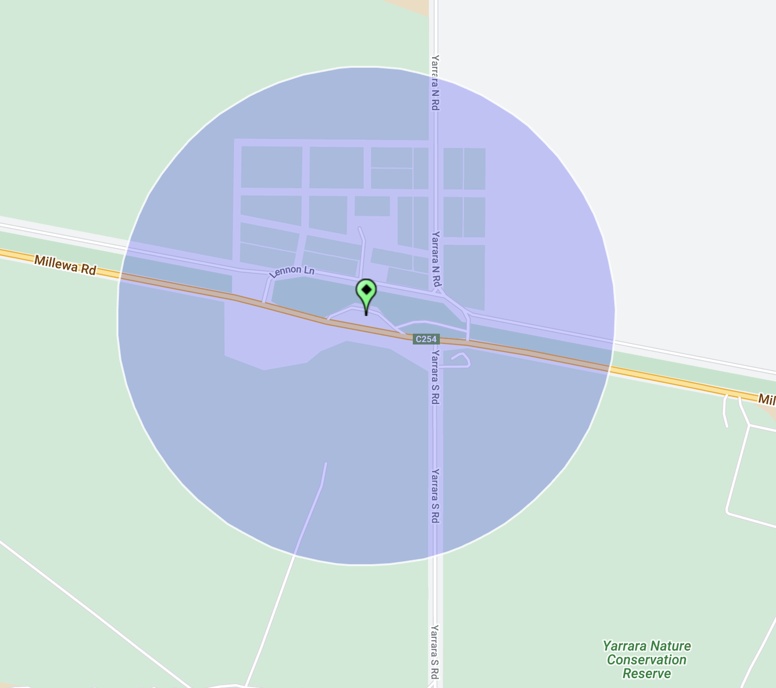
Our first activation for Monday 30th October 2023 was the Morkalla-Red Cliffs Railway Bushland Reserve VKFF-4217 and the Yarrara silo VK-YRA3.

Above:- Map showing the location of the Morkalla-Red Cliffs Railway Bushland Reserve. Map c/o Google Maps.
After breakfast at McDonalds in Renmark, we headed over the South Australian State border into the State of Victoria.
Along the way, we logged David VK5DG who was activating the Cooltong Conservation Park VKFF-0823. Signal reports of 5/9 both ways were exchanged. A short distance further along the Sturt Highway we pulled in quickly to the Murray Sunset National Park VKFF-0373 to make a Park to Park contact with David VK5DG.


A little further along the Sturt Highway, we logged Tony VK3YV who was activating the Hattah Kulkyne National Park VKFF-0231. We then spoke with Peter VK3PF who was activating Carwarp West I12 Bushland Reserve VKFF-4143.
We turned off the Sturt Highway and travelled south along the Merringur North Road until we reached the little town of Merringur in the Millewa district of northwest Victoria. The Merringur Post Office opened on the 2nd day of February 1926, with the railway reaching the area the year prior in 1925.

The Millewa is a large strip of land situated between sections of the Murray Sunset National Park. Its boundaries are the Murray River to the north, Mildura to the east, the South Australia state border to the west, and the Murray Sunset National Park to the south. It was once inhabited by the Latje Latje aboriginal people.
During the 1920s the Millewa region was opened up for settlement. Prior to this, only large pastoral holdings existed in the region. Prospective settlers were allocated an average of 750 acres of land as purchase leases for agriculture. By 1928 a total of 600,000 acres of land had been taken up by 708 settlers. This was not easy living. The land was semi-arid and experienced about 250mm of rain annually.
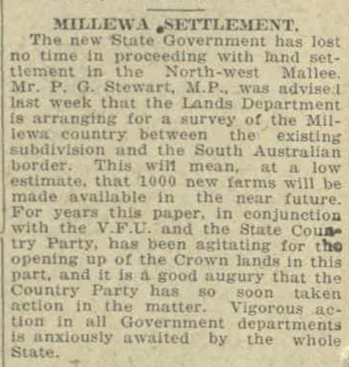
Above:- Article from the Countryman, Melbourne, Fri 28 Nov 1924. Image c/o Trove.
Today the Millewa region is a successful grain growing district, producing high protein quality wheat and malting grade barley. Much of this success has been due to the piping of water from the Murray River.
It was often slow going on the roads with farm machinery traversing the roads between farming properties.

We continued on to Yarrara, as I had not initially planned to activate the silo at Merringur. Our plans were to activate the Yarrara silo which was in the activation zone of the Morkalla-Red Cliffs Railway Bushland Reserve.
Above:- The activation zone at the Yarrara silo. Image c/o SiOTA website.
Morkalla is a locality in the Sunraysia region of Victoria. It is located at the farthest west point on the Redcliffs-Meringur Road. Morkalla is an aboriginal word meaning night. Following the end of the First World War, the Morkalla district was opened up to soldier settlers.

Above:- a plan of the township of Morkalla. Image c/o State Library Victoria.
To assist the settlers, the branch line west from Red Cliffs on the Mildura railway line was extended to Morkalla in 1931. It had been extended to Werrimull in 1924 and to Meringur in 1925. Morkalla was the furthest railway station from Melbourne.

Above:- An article from the Ouyen Mail, Wed 24 Jun 1931. Image c/o Trove.
There were stations/sidings at the following locations along the branch line (their aboriginal names are also included):
- Thurla opened 10th April 1924, closed 5th June 1939.
- Benetook – opened 10th April 1924, closed 5th June 1939 – ankle
- Pirlta – opened 10th April 1924, closed 5th June 1939 – opossum
- Merrinee – opened 10th April 1924, closed 5th June 1939 – south or wallaby
- Karawinna – opened 10th April 1924, closed 5th June 1939 – eaglehawk
- Werrimul – opened 10th April 1924, closed 5th June 1939 – emu
- Bambill – opened 30th October 1925, closed 5th June 1939 – box tree
- Yarrara – opened 30th October 1925, closed 5th June 1939 – wood
- Merringur – opened 30th October 1925, closed 5th June 1939 – Grey female kangaroo
- Karween – opened 16th June 1931, closed 5th June 1939 – grass tree
- Morkalla – opened 16th June 1931, closed 5th June 1939 – night.
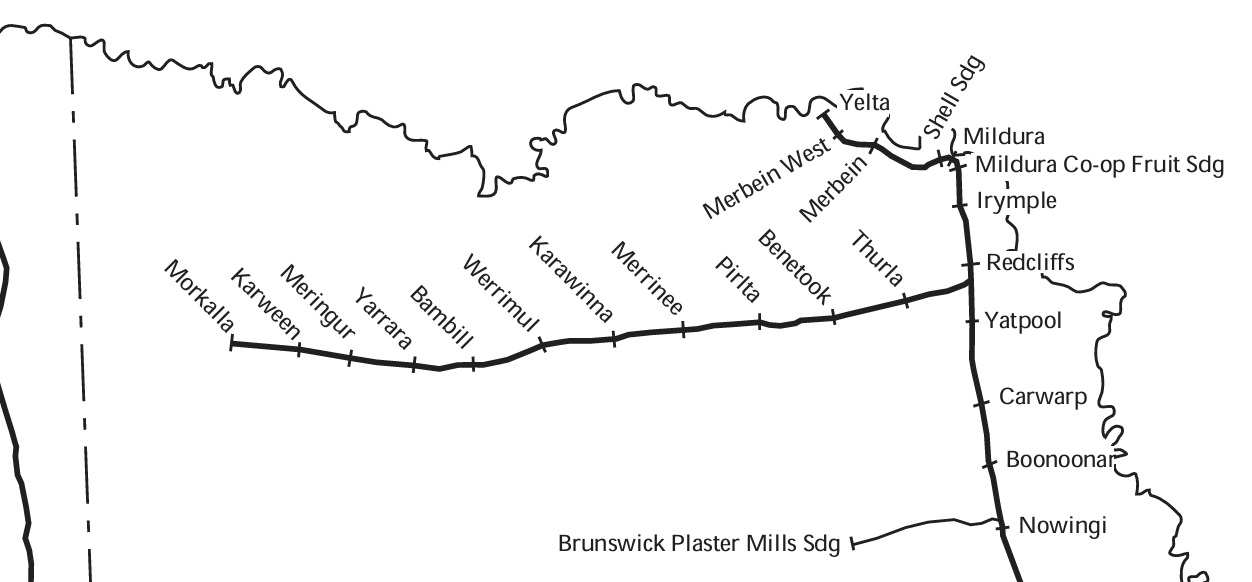
Above:- The Morkalla-Red Cliffs Railway line. Image c/o http://vrhistory.com/VRMaps/Vic1940.pdf
By 1939 Railway passenger facilities had been removed at Morkalla and in 1964 the line was closed. Not much remains at Morkalla apart from a few old sleepers indicating where the railway line once ran and the goods platform existed. Just the old railway platform exists at Karween. The old silos still exist at Merringur, along with the excellent Millewa Pioneer Park. This excellent pioneer park is well worth the visit if you are in the area. Nothing is evident at Bambil. The old silos still stand at Werrimul along with an old platform. Silos and the old good platform exist at Karawinna. Silos exist at Merinee and Pirlta. No sign of the railway exists at Benetook and Thurla.

Above:- Train crew posing next to the milepost indicating 403 miles (648 km) by rail from Melbourne on the Morkalla-Red Cliffs line. Image c/o Newport Railway Museum Facebook page.
Today, a two-kilometre section of the old 1600 mm gauge railway line has been converted to 610 mm gauge for a tourist train that operates on the line run by the Red Cliffs Historical Railway.
The remainder of the line is now the Morkalla-Red Cliffs Railway Bushland Reserve which is about 565 hectares in size and was established in May 1990.


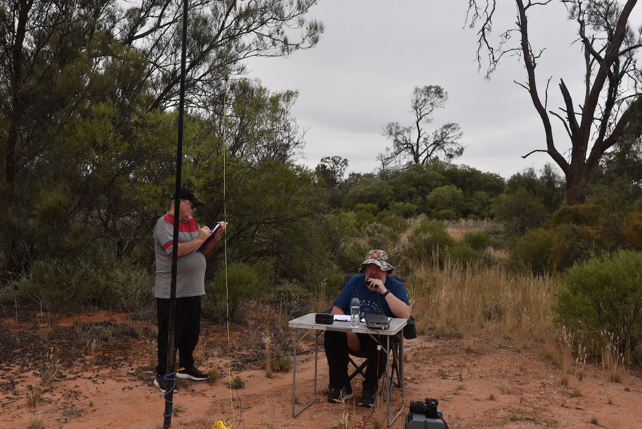
We set up at Yarrara in the Reserve and within the activation zone of the Yarrara silo.
Yarrara, once a thriving community, is an aboriginal word meaning wood.

Above:- Plan of the township of Yarrara. Image c/o State Library Victoria.

Above:- harvesting at Yarrara, c. 1927. Image c/o Museums Victoria.
The Yarrara station opened on the 30th day of October 1925 and closed on the 5th day of June 1939.

Image c/o Millewa History photos Facebook page.
Today very little remains of Yarrara. There are a few scattered houses and the silos of course. The town once flourished and had a Country Women’s Association, its own football club and an oval. The Yarrara Hall which was opened in 1935 and closed in 1944, is now located in the Millewa Pioneer Village at Meringur.

Above:- An aerial view of Yarrara. Image c/o Google Maps.
Other than the Railway Bushland Reserve, Yarrara also has the Yarrara Nature Conservation Reserve in close proximity.
The Yarrara silos are constructed of steel and have 50,000 bushel capacity.

Above:- part of an article from The Horsham Times, Tue 14 Mar 1933. Image c/o Trove.


Above:- article from the Sunraysia Daily, Tues 7 Mar 1933. Image c/o Trove.
We ran the Yaesu FT857, 40 watts, and the 20/40/80m linked dipole for this activation, in an inverted v configuration, supported by a 7-metre heavy-duty telescopic squid pole.
Marija worked the following stations on 40m SSB before the UTC rollover:-
- VK2USH
- VK2EXA
- VK3CLD
- VK2GOM/p (Kate Reed Nature Recreation Area VKFF-1141)
- VK2VAR/ (Kate Reed Nature Recreation Area VKFF-1141
- VK2BYF/p (Kate Reed Nature Recreation Area VKFF-1141)
- VK2VT/p (Kate Reed Nature Recreation Area VKFF-1141)
- VK3OAK/p (Murray River National Park VKFF-0372)
- VK3PWG/p (Murray River National Park VKFF-0372)
- VK2IO/p (Murray River National Park VKFF-0372)
- VK3PF/p (Carwarp West I12 Bushland Reserve VKFF-4143)
- VK3YV/p (Hattah-Kulkyne National Park VKFF-0231)
Marija worked the following stations on 40m SSB after the UTC rollover:-
- VK1DI/p (Hattah-Kulkyne National Park VKFF-0231)
- VK3PF/p (Boonoornar Bushland Reserve VKFF-4146)
I worked the following stations on 40m SSB before the UTC rollover:-
- VK2USH
- VK2EXA
- VK3CLD
- VK2GOM/p (Kate Reed Nature Recreation Area VKFF-1141)
- VK2VAR/ (Kate Reed Nature Recreation Area VKFF-1141
- VK2BYF/p (Kate Reed Nature Recreation Area VKFF-1141)
- VK2VT/p (Kate Reed Nature Recreation Area VKFF-1141)
- VK3OAK/p (Murray River National Park VKFF-0372)
- VK3PWG/p (Murray River National Park VKFF-0372)
- VK2IO/p (Murray River National Park VKFF-0372)
- VK3PF/p (Carwarp West I12 Bushland Reserve VKFF-4143)
- VK3APJ
- VK3YV/p (Hattah-Kulkyne National Park VKFF-0231)
- VK5AHZ
- VK5AYL
- VK3TKK/m
- VK3VIN
- VK5HOL/m
- VK3CWF
- VK3CEO
- VK3SO
- VK5HS
- VK5IS
- VK3NAD
- VK5FIVE
- VK5AAF
- VK3VMM
- VK3UH
- VK1AD
- VK1NAM
- VK1DI/p (Hattah-Kulkyne National Park VKFF-0231)
I worked the following stations on 40m SSB after the UTC rollover:-
- VK1DI/p (Hattah-Kulkyne National Park VKFF-0231)
- VK3UH
- VK1AD
- VK1NAM
- VK3CEO
- VK3VIN
- VK5FIVE
- VK3YV/m
- VK3CLD
- VK3PF/p (Boonoornar Bushland Reserve VKFF-4146)
- VK1AAF
- VK5HS
- VK2IO
I worked the following stations on 20m SSB:-
- VK4MUD
- VK4KC
- VK4MAD
- VK4DOG
- VK8DJ
References.
- Blake, Les, 1977, Place Names of Victoria.
- Flickr, 2023, <https://www.flickr.com/photos/129023979@N05/49475489982>, viewed 16th December 2023.
- Flickr, 2023, <https://www.flickr.com/photos/129023979@N05/49489983161>, viewed 16th December 2023.
- Millewa Pioneer Park, 2023, <https://www.millewapioneerpark.org.au/millewa.htm>, viewed 16th December 2023.
- trainsandtrams.com, 2023, <https://www.trainsandtrams.com/railways-maps/station-details/>, viewed 16th December 2023.
- Wikipedia, 2023, <https://en.wikipedia.org/wiki/Morkalla,_Victoria>, viewed 16th December 2023.
- Wikipedia, 2023, <https://en.wikipedia.org/wiki/Morkalla_railway_line>, viewed 16th December 2023.
