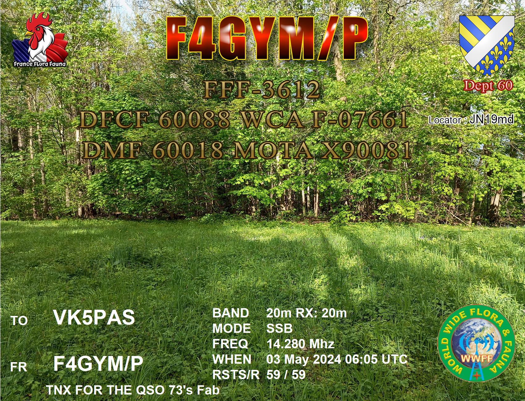
Here is a selection of QSL cards that have arrived in the mail in the past couple of weeks for VK5MAZ and VK5PAS.


Here is a selection of QSL cards that have arrived in the mail in the past couple of weeks for VK5MAZ and VK5PAS.
My next activation for Wednesday 10th April 2024 was the Redhill silo VK-RDL5 for the Silos On The Air (SiOTA) program. Redhill is about 178 km north of the city of Adelaide.

Above:- Map showing the location of Redhill, South Australia. Map c/o Google Maps.
Redhill was established in the late 1800s and was originally known as Redbanks but was changed due to the clash with Redbanks on the River Light. It was then known as Broughton. The town had a hotel, blacksmith, general store and other businesses. The town was officially renamed Red Hill in 1940, but it was known as Red Hills many years prior to this. (Cockburn 1984) (New Town Names 1940)

Above:- Article from The Advertiser, Fri 26 Jul 1940. Image c/o Trove.
Redhill came into existence following the opening of the northern areas of South Australia to farmers. It was initially little more than a ‘roadside stopping place.’ In 1875 Redhill was described as having only 20 houses, two machinist shops, a roomy hotel and a flour mill. By this time Redhill was the centre of traffic between Clare and Port Pirie. Travellers from Adelaide journeyed by rail to Saddleworth and then by coach to Clare, Koolunga, Redhill, Merriton and Port Pirie. (Redhill Railway Town 1925)
Early residents of Redhill included W.B. Wilkinson, G.F. Claridge, C.G. Adley, L.R. Wake, and G.F. Pearce.(Redhill Railway Town 1925)
George Frederick Claridge was born in 1852 in Oxfordshire, England. He emigrated as a child to Australia in 1854 and initially worked in a drapery shop and then his father’s general store at Auburn which prospered with branches opening at Redhill and Crystal Brook. He founded a branch of the District Trained Nursing Society and became involved in politics. He became Mayor of Port Pirie 1898-1899. He was a member of the Destitute Board and an active member of the Home for Incurables. He was a member of the Adelaide and Midland Licensing Benches and the Special Licensing Bench, the Adelaide Hospital advisory board; and the State Children’s Council. He died in 1931. (Death of Mr GF Claridge 1931)

Above:- George Frederick Claridge. Image co State Library South Australia.
Sir George Foster Pearce (G.F. Pearce), was born in 1870 at Mount Barker. During his early childhood he the family lived in various rural locations in South Australia, including Redhill where he was educated. Pearce went on to serve as a Senator for Western Australia from 1901 to 1938. Although he commenced his political life with the Labor Party, he later joined the National Labor Party, the Nationalist Party and the United Australia Party. He served as a cabinet minister under Prime Ministers from all four parties. (Aust Dict of Biography 2024) (Redhill Railway Town 1925)
Pearce died in 1952 in Victoria, aged 82 years. Several places are named in his honour including RAAF Base Pearce, the electoral Division of Pearce in Western Australia, Pearce Peak in Antarctica, and the Canberra suburb of Pearce. Australia’s longest-serving Prime Minister, Robert Menzies stated that he had “never sat with an abler man than George Pearce” in cabinet. (Biog Dict of Australian Senate 2024)

Above:- Sir George Foster Pearce. Image c/o Wikipedia.
William Birkinshaw Wilkinson, commonly referred to as W.B. Wilkinson, was born in 1854 in England, and emigrated to Australia in 1875. He was initially employed with the National Bank of Australasia, but soon after founded Davey and Wilkinson auctioneers of Redhill with John Francis Davey. Wilkinson then became Senior partner in a firm Wilkinson, Harrison & Porter. Wilkinson often travelled overseas and founded the Australasian Club in London. He subsequently commenced a real estate business Wilkinson, Sando & Wyles Ltd. Wilkinson was elected a Fellow of the Royal Geographical Society. He was a councillor for Robe Ward in the Adelaide City Council, President of the General Employers Union, President and founder of the Licensed Land Brokers and Auctioneer’ Association, President and a founder of the North Adelaide branch of the Liberal Union, member of the Board of Governors of the Public Library, Museum, and Art Gallery, chairman and trustee of the Kindergarten Union, member of the executive and past chairman of St. John Ambulance Association, founder, past President, and member of the executive of the Commonwealth Club of Adelaide, member of the executive and honorary treasurer of the Queen’s Home, founder and member of the executive of the Town Planning Association, President of the North Adelaide circle of the Australian Division (men’s section) of the British Red Cross Society and President of the Men’s Tobacco Auxiliary (South Australian division) of the Australian Comforts Fund. Wilkinson died at his home in North Adelaide in 1927. (Prominent Businessman 1927)

Above:- W.B. Wilkinson. Image c/o Wikipedia.
The main highway bypasses Redhill. The town is located adjacent to the Broughton River which flows about 110 km from south of Spalding to the Spencer Gulf.

The Broughton River was named by explored Edward John Eyre (b. 1815. d. 1901) in May 1839 in honour of the Right Rev. William Grant Broughton, the first and only Bishop of Australia of the Church of England. (Cockburn 1984)

Above:- William Grant Broughton. Image c/o Wikipedia.
On the edge of the highway is a sculpture of a pioneer farmer and his horse working the land. It is a tribute to those who settled in the Redhill district.

As you enter the town there is a monument dedicated to the pioneers of Redhill and commemorating the 150 year celebrations 1869-2019.

Redhill contains several historic buildings.


The corner store and post office can be located in Bowman Street.

The Redhill Institute Soldiers Memorial Hall can be found in Barr Street. The foundation stone was laid on the 24th day of September 1919.

Sadly the town’s hotel, the Eureka Hotel is now closed. The first hotel, a single-storey building g opened in 1874 but closed in 1899. The impressive two-storey Eureka Hotel opened in 1878.

Mr. W.J. Reynolds built the hotel. (Redhill Railway Town 1925)

Above:- the Eureka Hotel, Redhill. Image c/o State Library South Australia.
The former St. Andrews Church of England was built in 1881 and was designed by Red Hill Bank Manager William Kingsnorth Mallyon. He had no formal training in architecture, draughtsmanship or building. Mallyson went on to design several churches, predominantly for the Diocese of Willochra. (State Library 2024)

The former Methodist church is located in Ellis Street.

The old Redhill Council Chambers built in 1898 now serve as a museum. The school bell from the old Redhill Primary School can be found outside the museum.


The broad gauge railway from Adelaide reached Redhill in 1925. In 1969 the standard gauge line was built. Below are some photos of the old platform, the most recent railway station, and the old crane.


When the railway was opened in 1925, The Mail Adelaide newspaper reported:-
“Situated as it is in the centre of the richest wheat growing area in South Australia, Redhill despite the lack of railway facilities has always been a prosperous and thriving township. Today, with a population of 250, and 64 houses, it has three fine churches, two banks, a hotel, a school, an institute, and a post office…” (Redhill Railway Town 1925)
Below is the article in full. It makes for some very interesting reading.


A monument can be found in the town to commemorate the opening of the first bridge over the River Broughton at Redhill. It was built in October 1876 of wooden construction.


In 1909 the original bridge was washed away and replaced with the present steel structure. Only the stone abutments of the original bridge remain.

Above:- Article from The Express and Telegraph, Adelaide, Fri 30 Jul 1909. Image c/o Trove
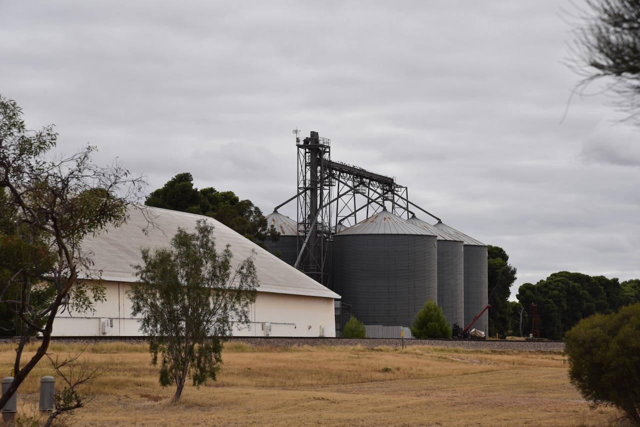
The silos at Redhill are located on the southern side of the town, alongside the railway line.


I parked on Hydon Road and operated from the 4WD for this activation. I ran the Icom IC-7000, 100 watts, and the Codan 9350 antenna with the 1.5 metre stainless steel whip.

Above:- The activation zone at the Redhill silos. Image c/op SiOTA website.
I worked the following stations on 40m SSB:-
I worked the following stations on 20m SSB:-
References.
Whilst I was away on the Eyre Peninsula, I became aware of the results of the 2023 Oceania DX Contest.
I came 1st in Australia and Oceania in the Single Operator Low Power All Band Phone category.
Below is my winning certificate.

And below is my participation certificate.

Thank you to everyone who called, and thank you to the organisers and sponsors of the Oceania DX Contest.
Back on the 19th of February 2024, I made contact on the 20m band with Dave VK5MRD who was aeronautical mobile in a Flying Doctor aircraft in the Northern Territory.

The aircraft was a Pilatus PC-24 VH-FMP, callsign FlyDoc501.

Here is a selection of QSL cards recently received via email.


Last night’s light show here at Ashbourne. Taken with the iPhone.

Certificate received for 100 years of Radio and Amateur Radio in Spain 1924-2024

A few weeks ago I received the following QSL confirmation from the Voice of the Martyrs for my reception of their station on 15570 kHz on 17th October 2023.

After leaving Dublin (Wednesday 10th April 2024) I travelled north along Port Wakefield Road-Highway A1 reaching the town of Port Wakefield. I then continued north along the Augusta Highway. I stopped at the little town of Lochiel to stretch my legs.
Lochiel is about 125 km north of Adelaide and lies on the western edge of Lake Bumbunga and at the eastern foot of the Hummocks Range.

Above:- Map showing the location of Lochiel. Map c/o Google Maps.
The town of Lochiel was surveyed in 1869. The South Australian Governor Sir James Fergusson (b. 1832. d. 1907) gave the Scottish name Lochiel to the site of the town. It is the name given to the senior line of Chiefs of Clan Cameron, a West Highland Scottish clan. Lochiel’ comes from the Gaelic ial – ‘gleam of sunshine’. The town of Lochiel is situated in the Hundred of Cameron, named after pioneer Hugh Cameron. (Cockburn 1984) (Manning 2024)

Above:- Sir James Fergusson. Image c/o Wikipedia.
One of Lochiel’s tourist attractions is Lake Bumbunga, a salt lake with a surface area of about 13.88 km2. The lake often appears to be a bright pink colour due to certain algae. Lake Bumbunga is the largest of a system of saline lakes extending about 30 km north of Lochiel, draining an area to the east of the Barunga Range, where it merges with the Hummock Range. (Hough 2008)
Salt has been mined at Lake Bumbunga since 1881. By 1910 there were at least three lease-holders scraping thousands of tons of salt at Lake Bumbunga. The Australian Salt Company held the lake leases from 1913 to 1971 when the company became a wholly owned subsidiary of Cheetham Salt Company Ltd (now Cheetham Salt Ltd), Australia’s largest producer and refiner of solar salt.
In 1926, a branch line was constructed from the Salisbury railway line, allowing salt transport directly to Port Adelaide. (Fuss 2012)

Above:- Part of an article from The Register, Thu 18 Nov 1926. Image c/o Trove.
Salt was required for munitions manufacture during World War II, and this resulted in employment rising from 30 to 100 workers. There were three shifts a day with two trains a week transporting salt in bags to Port Adelaide. By 1967 a total of 1,000 tonnes were harvested a day. This was at a time when South Australia was pricing 80% of Australia’s salt. Between 1996 to 2012 the salt works were closed. (Fuss 2012)

Above:- Salt heaps at Lochiel, c. 1930. Image c/o State Library South Australia.
Bumbunga is believed to be derived from the aboriginal word parnpangka meaning ‘rainwater lake’. (Place Names 2024)
One of the reasons why tourists stop at Lochiel is to view the fibreglass structure ‘Loch Eel Monster’ which is located in the middle of the lake. The original monster was built from old rubber tyres and plastic by a local man Gary Taylor and his friends. It was named ‘Loch Eel’ a humorous take on Scotland’s infamous Loch Ness Monster. In 2017 the head was stolen, and work commenced on a fibreglass replacement. But why a monster in the middle of the lake? In the late 1880s bullock teams were common in the area. Legend has it that a team of bullocks were walking over the lake when they were ‘spooked by some sort of monster.’ (Escape to Lochiel 2021)


Lake Bumbunga has been used as a background for various advertising over the years including R.M. Williams, Mercedes Benz, and Foxtel. Fashion shoots for the Adelaide Fashion Festival have also been held at the lake. The TV series Upright used Lake Bumbunga as a filming location. (ABC 2023) (Escape to Lochiel 2021)
I then drove a further 19km to the north and reached the town of Snowtown, where I stopped to activate the silo for the Silos On The Air (SiOTA) program.


Snowtown is about 145 km north of Adelaide in the Mid North of South Australia.

Above:- Map showing the location of Snowtown, South Australia. Map c/o Google Maps.
The traditional owners of the area around Snowtown are the Kaurna aboriginal people. European pioneers commenced arriving in the district during the 1840s. The area saw the rapid expansion of grazing and farming. In 1847 pastoral lease 395 was granted to Edward Burton ‘Paddy’ Gleeson. The area was known as Black Point due to the hill to the east of Snowtown, Black Point Hill and the nearby Black Point Lagoon. Gleeson built a homestead at Black Point. (Snowtown Museum 2020)

Above:- Edward ‘Paddy’ Gleeson. Image c/o State Library South Australia.
Pioneer John Ellis leased the large Hummocks Run to the west of Black Hill. He built a stone homestead at Barunga Station between 1860-1863. In 1864, the South Australian Register referred to ‘Hummock Run’ containing the head station at Barunga, and two subhead stations at Bumbunga and Wokurna. The land was described as consisting of salt lakes, lagoons and dense scrub. (Hummocks Run 1864) (Snowtown Museum 2024)

Above:- Part of an article from the South Australian Register, Tue 27 Sep 1864. Image c/o Trove.
From the early 1860s, European settlers and graziers campaigned for more suitable transport routes from Black Point to Kadina for wool and wheat. In 1867 a Parliamentary Enquiry delivered a report which recommended the Clare to Wallaroo railway be built at a cost of £144.15s. Following the arrival of the influential Robert Barr Smith at the Hummocks Run in 1870, surveyors arrived in the district. A paved road was constructed in 1874, followed by the railway in 1878 from Kadina to Barunga, now Barunga Gap. (Weekly Chronicle 1864)

Above:- Article from the South Australian Weekly Chronicle, Sat 12 Apr 1862. Image c/o Trove.
On the 25th day of September 1877, the Commissioner for Crown Lands Hon. J. Carr, agreed that a township should be established at Black Point. It was at this time that the railway was extended from Barunga Gap to Black Point.

Above:- Article from The Express and Telegraph, Adelaide, Tue 25 Sep 1877. Image c/o Trove.
Snowtown was proclaimed on the 19th day of December 1878 by Governor William Jervois who named the town after one of the members of the Snow family who were his cousins who resided on the Yorke Peninsula. It is believed the town was named in honour of Thomas Snow, who became Jervois’s aide de camp when he received his posting in South Australia.

Above:- William Jervois. Image c/o Wikipedia.
The town boundaries were defined as an approximate rectangle immediately adjacent to section 114 in the Hundred of Barunga northeast of Barunga Creek, northwest of Salt Lagoon and south of Boundary Creek. On the 16th day of January 1879, the first town allotments were sold for cash only. (SA Govt Gazette 1878)

Above:- The proclamation of Snowtown, SA Govt Gazette, 19 Dec 1878.
As you drive into Snowtown, there is an excellent information board with some history on Snowtown.


In 2017 the Snowtown community commissioned a mural to be painted by Joel Van Moore ‘Van the Omega’ on the Snowtown water tower in Railway Terrace. The murals on the tower feature local volunteers and sports stars. (Australian SIlo Art 2024)

The Snowtown Wind Farms were commissioned in September 2008, with 47 wind turbines. In 2011 an additional 90 turbines were installed. The two independently run wind farms produce an annual combined total output of about 1350GWh, enough to power 230,000 South Australian homes.


Snowtown contains several historic buildings.

The Snowtown Soldiers Memorial Hall commemorates those who served in World War One. The foundation stone was laid on the 4th day of October 1924 by Governor Sir Tom Bridges with the official opening in May 1925 by Major W. F. J. McCann D.S.O., M.C., in May 1925. (Monument Australia 2024)

One of the first buildings to be constructed in Snowtown was the hotel in 1879. It was constructed by Mr. Richard Hazelgrove who paid £171 for block 160 on which he built the hotel. It was extended in 1913. (Snowtown Museum 2024)

Located at Fourth Street is the old English Scottish and Australian Bank. The building was constructed in 1882 and has been restored and repainted in heritage colours. (Aussie Towns 2024)

The old butcher and bakery business commenced in 1889. The corner shop was added to the original shop in 1910. (Flickr 2024)

The former St Canice’s Catholic Church is located in Railway Terrace West. The Foundation stone was laid on the 11th day of August 1935 by Bishop Killian. The architect was H H Jory. The church opened on the 26th day of January 1936. (Churches Australia 2024) (Flickr 2024)


After having a look around Snowtown, I drove to the Snowtown silos VK-SNN5 to activate the silos for the Silos On The Air (SiOTA) program.


I parked in Railway Terrace West and operated from the 4WD, running the Icom IC-7000, 100 watts, and the Codan 9350 antenna with the 1.5 metre stainless steel whip.

Above:- the activation zone at the Snowtown silos. Image c/o SiOTA website.
I worked the following stations on 40m SSB:-
I worked the following stations on 20m SSB:-
References.
My first activation on Wednesday 10th April 2024 for the Eyre Peninsula trip was the Dublin silo VK-DN5, for the Silos On The Air (SiOTA) program. Dublin is about 65 km north of the city of Adelaide.

Above:- Map showing the location of Dublin, South Australia. Map c/o Google Maps.
Dublin lies in the cadastral Hundred of Dublin which was named in 1856 by Governor Richard MacDonnell in honour of his birthplace of Dublin in Ireland. It was officially proclaimed on the 22nd day of May 1856 and covered an area of 91,520 acres. (Cockburn 1990) (Dublin History Group 2012)

Above:- Sir Richard Graves MacDonnell. Image c/o Wikipedia.
The first known landowners in the Hundred of Dublin were Messes Grant and Butler, who in 1851, secured a 14-year lease in lieu of an occupation licence. In 1873 the township of Dublin was surveyed and on the 13th day of April 1876, the township was gazetted. The town plan was based on the principles used by Colonel William Light in the planning of the city of Adelaide. Other early settlers at Dublin included Thomas Stephenson in 1866, Charles Burney Young in 1873, William and Jonathon Porter in 1874, and Robert Dawson and William Camens in 1876. (Dublin History Group 2012)


The Dublin silos are part of Dublin Clean Grain, a leading grain cleaning service north of Adelaide. The Dublin silo complex has a 780 tonne silo storage capacity feeding directly to a Cimbria 108 sieve cleaner and two Cimbria gravity tables. There are six 130 tonne silos. Grains that are cleaned at the complex include wheat, lentils, beans, barley, canola, and peas. (Dublin Clean Grain 2024)


I parked on Carslake Road and operated from the 4WD, running the Icom IC-7000, 100 watts, and the Codan 8350 antenna with the 1.5 metre stainless steel whip.
I worked the following stations on 40m SSB:-
I worked the following station on 20m SSB:-
References.
Amateur Radio, Short Wave Listening
Amateur radio experiences with VK1DA
Brisbane - Australia
german amateur radio station
Just another Amateur Radio Operator
Summits On The Air
SOTA on the peaks, wilderness QRP and some bushwalking
A fine WordPress.com site
Amateur Radio Adventures
Summits on the Ai
Amateur radio station from Belgium
Radio craft, homebrew, QRP/SOTA, AM
Ego loqui ad viros super montes
My adventures with Amateur Radio and Geocaching!
The rantings of VK2GAZ on his SOTA experiences in Australia
A survivor, with minor cuts and abrasions.
The Art and Craft of Blogging
The latest news on WordPress.com and the WordPress community.
Blog of Justin Giles-Clark VK7TW's SOTA and amateur radio adventures.
