An afternoon of touristy stuff

After leaving Mount Clay, Marija and I drove back to the Princes Highway and continued east through Tyrendarra and Tyrrendarra East.  We stoppe briefly at the Codrington Wind Farm for a cup of coffee and some cake.

The Codrington wind farm was Australia’s first commercial wind farm and was officially opened in July 2001.  A the time of its opening, it was also the largest wind farm iun Australia, with 14 turbines and an installed capacity of 18.2 MW.  The wind farm now generates enough electricity each year to supply the equivalent of 10,000 Victorian homes and each year avoids the emission of 49,000 tonnes of greenhouse gas emissions – the equivalent to taking more than 17,000 cars off the roads.

We continued on towards Port Fairy, kwhere we intended to have some lunch.  Along the way we passed through Yambuck and then took Craggs Road down to a little spot on the coast called The Crags, which is one of the most rugged and wild sections of Victoria’s coastline.  It is just 12 km west of Port Fairy.  Off the coast you can see Lady Julia Percy Island, which is home to more than 4000 seals, fairy penguins, birds of prey and has the largest Australian rookeries of fairy prions and diving petrels.

There is also a monument here, which was erected in memory of four Royal Australian Air Force personnel who lost their lives when their plane lost contact with its base in Mount Gambier on February 15th 1944.  The crew attempted to land the plane, which was an Avro Anson, on Lady Julia Island, but crashed.  The aircraft was on submarine surveillance at the time.

For more information, please see…..

http://www.ozatwar.com/ozcrashes/vic181.htm

We then drove in to Port Fairy which is a beautiful little town of around 2,600 people.  The town was originally known as Belfast.  At its peak, the port was the second busiest in Australia.  Wool, wheat, and grain were loaded onto sailing ships bound for England.

After stopping at the Visitor Information Centre, we went on the Port Fairy historic walk.  It was a beautiful afternoon walk in the sunshine, and there are over 50 buildings from the boom area of the town, classified by Australia’s National Trust.

We then went on the Griffiths Island Lighthouse walk.  The lighthouse was built in 1859 at the tip of Rabbit Island.  As we pulled up I worked Brian VK3MCD who was on a SOTA summit.

We also stopped off to have a look at Battery Hill.  The site of the Port Fairy Battery was used for defence purposes from 1867, when a 32 pdr smooth-bore muzzle-loaded artillery piece was installed.  Another was installed in 1872.  Further defences were added in 1874 including a redoubt.  In 1877, more permanent fortifications were constructed and 2 years later, two 80 pdr rifled muzzle-loaded Armstrong artillery pieces with iron traversing carriages were installed in concrete emplacements.

We then enjoyed some lunch down by the Moyne River which flows through the town of Port Fairy.  We were joined by some very cheeky ravens and seagulls.  It was around this time that I worked Brian VK3MCD, who was on another SOTA peak.

We continued on to the Tower Hill Wildlife Reserve, which is located between Port Fairy and Warrnambool.  This park is a major natural landmark and is a giant maar or volcanic explosion crater.  It is of international and national geological significance.  Unfortunately we did not get enough time to explore here, and this park is definitely on our list when we return to the area.  I am even thinking about adding it to the Victorian parks list for the World Wide Flora Fauna (WWFF) program.

For more information on Tower Hill, please see…..

http://www.towerhill.org.au/

After leaving Tower Hill, we continued on in to Warrnambool, where we booked in to our motel, The Blue Whale, and later that night enjoyed a very nice meal at the Whalers Hotel.


References.

Glenelg Shire, Guns & Cannon along Victoria’s South West Coastline.

Pacific Hydro, 2015, <http://www.pacifichydro.com.au/english/projects/operations/codrington-wind-farm/&gt;, viewed 4th December 2015

Port Fairy-Moyne Shire, 2015, <http://www.visitportfairy-moyneshire.com.au/activitiesattractions/coastal/476-the-crags-end-to-a-great-ocean-adventure&gt;, viewed 4th December 2015

Mount Clay VK3/ VS-051

After two enjoyable nights in Portland, it was time to continue our journey further east.  So it was a relatively early start on Wednesday 11th November, 2015.  We were to travel to Warrnambool that day, and activate SOTA summit Mount Clay in the morning.

Mount Clay is about 30 km north east of Portland, and is very easy to find.

Screenshot 2015-12-04 13.59.10

Above:- Map showing the location of Mount Clay.  Image courtesy of googlemaps.

We travelled north out of Portland along the Princes Highway through Portland North, Allestree and then Narrawong.  Just before reaching Tyrendarra, we turned left onto Mount Clay Road and travelled north west until we reached Tower Road.

Screenshot 2015-12-04 13.59.29

Above:- Map showing the location of Mount Clay, to the north east of Portland.  Image courtesy of google maps.

There were some good views of Mount Clay as we travelled along the Princes Highway.  All of the telecommunications gear on top of the summit, makes the hill very distinguishable.

DSC_0351

We continued west along Tower Road, travelling passing the State Forest on the northern side of the road,  We then turned left onto Angelino Road and travelled a short distance south.

It was slow going as there was plenty of local wildlife out and about.

At the end of Angelino Road, which is a no through road, you will reach a locked gate.  And I mean a locked gate.  There is a plethora of padlocks on the gate.

It was at the gate that we set up.  You are well within the activation zone at this location.  The trig point is clearly visible from here.  It is from this spot that I previously activated the summit.

I last activated Mount Clay summit back in November 2014, as part of the 2014 SOTA Spring Activation Weekend.  For more information on that activation, please see…..

https://vk5pas.org/2014/11/30/mount-clay-vk3-vs-051/

Screenshot 2015-12-04 13.59.42

Mount Clay, VK3/ VS-051 is 186 metres above sea level and is worth just 1 SOTA point.  But I have long given up reaching the lofty heights of Mountain Goat, and now just participate in the Summits on the Air (SOTA) program exclusively for fun.


This was another tough portable activation.  Not because the summit was difficult to get to.  In fact it is quite the opposite, as this is a very very easy summit.  The difficulty was the band conditions.  Again, they were very very poor.  I called and called CQ for many minutes until my first caller came back.  That was Adrian VK5FANA who was a good 5/6 signal from the Yorke Peninsula, west of Adelaide.  Adrian also gave me a 5/6, but it was very noticeable that there was major QSB on both of our signals.  My second caller was Cliff VK2NP who was 5/5 and gave me a 4/1.  Next up was Gerard VK2IO who was very low down (5/1) and responded with a 3/2 for me, with again huge QSB on both signals.

I continued to call CQ for the next 5 minutes but sadly I had no takers.  The fourth and qualifying contact for a successful SOTA activation was proving to be very elusive.  As it was a Wednesday morning, I knew that the Riverland Radio Group Net would be on 7.115, so that is where I headed.  Sadly I could not hear Ron VK5MRE, the Net Controller.  Not even a peep from Ron!  But I did manage to work Dennis VK2HHA who was a good strong 5/8.  As Dennis was my fourth contact, I breathed a sigh of relief, as the summit had been qualified.

I then moved back to 7.090 and called CQ again and this was answered by Greg VK2MTC, followed by Brett VK2VW, and then Nev VK5WG.  But that was the end of callers on 40m.  Numerous CQ calls went unanswered, so I decided to head up to 20m.  Sadly, it was no better there.  Despite spotting myself on SOTAWatch, I had no callers on 20m.

Netherless, I had qualified the summit and decided to pull stumps and pack up the gear.  I had noticed a tradies van at the summit, so I decided to walk over to see if they would mind if I took some photos from the eastern side of the summit.  As it turned out, it was Norbert VK5MQ from Mount Gambier, who was doing some work at the summit.

After a bit of a chat with Norbert I walked back to the 4WD where Marija was patiently waiting.  The photo below shows the view back to the gate on Angelino Road from the tower installations.

DSC_0376

It was off to Warrnambool.  And it was slow going again as we left, as we had a number of local onlookers.

DSC_0379

Not the greatest of SOTA activations in history.  Only 7 contacts in the log.  But still, the summit had been qualified.

The following stations were worked on 40m SSB:-

Screenshot 2015-12-04 13.47.56

Cape Nelson State Park VKFF-0754

After activating the Discovery Bay Coastal Park, Marija and I headed for the Cape Nelson State Park, VKFF-0754.  We travelled back into Portland and then headed south along the Norman Wade Scenic Drive, which follows the coastline.

Screenshot 2015-12-04 12.27.08 (1)

Above:- Map showing the location of the park.  Courtesy of Forest Explorer.

It wasn’t long before we had reached the park, and our first encounter with some of the local wildlife.  The speed limit is marked as low as you enter the park, and for good reason.  As we were travelling along, a koala crossed the road directly in front of us and then made a mad dash up a nearby tree.  We stopped for a quick photo opportunity.

There are a number of points along Norman Wade Scenic Drive where you can stop and admire the views of the coastline.

We also came across this rather amazing sight (see below) of a paddock absolutey full to to the brim with cattle amongst the wind farm.  I don’t think I’ve seen so many cows in the one paddock!

DSC_0314

The imposing figure of the Cape Nelson lighthouse soon came into view as we travelled south. We headed for the lighthouse prior to the park activation.

DSC_0315

The Cape Nelson lighthouse was constructed between 1882-1884.  Its height is 32 metres and it is constructed of bluestone.  There was a delay in the lighthouse being finally lit, and this was due to a delay in construction as a result of difficulty in obtaining suitable bluestone for the project.  Bluestone had originally been quarried from nearby, but this soon ran out.  Eventually, suitable stone was located at a site about 11 km away.  However there was no direct road and the stone had to be carted via Portland, a distance of around 21 km.  A total of 20 hands and 25 cutters were employed at the quarry, and 15 teams were employed to cart the dressed stone to the lighthouse.

For more information on this fascinating structure, please see…..

http://www.capenelsonlighthouse.com.au/

http://www.lighthouses.org.au/lights/Vic/Cape%20Nelson/Cape%20Nelson%20Lighthouse.htm

We then drove back along the Cape Nelson Road and onto Norman Wade Scenic Drive.  We found a little dirt track running off from there, which took you to a parking area.

Screenshot 2015-12-04 12.26.23

Above:- Our operating spot.  Courtesy of Forest Explorer.

From here it was a very short walk through the scrub to a nice little picnic area, which had a wooden table and benches.  A great shack!

DSC_0335

Cape Nelson State Park is situated about 12 km south of Portland.  The park is about 243 hectares (600 acres) in size, with the main vegetation within the park being Soap Mallee, Heath and Wet Heath.  A number of native animals call the park home.  We had already encountered a koala, but it wasn’t long before we had another visitor in the picnic area, an echidna.

This was a very pretty spot, but sadly it was not going to be an entirely successful activation.  I started calling CQ on 7.144 and this was eventually answered by Peter VK3PF with an excellent 5/9 signal.  This was followed by Brett VK2VW (5/6 sent and 5/3 received), followed by John VK5BJE (5/3 sent and 5/1 received), and then Gerard VK2IO 95/7 both ways).  Band conditions on 40m were very poor, with lots of very deep QSB.

I persevered and kept calling CQ, and worked a further 10 stations in VK2, VK3, VK4, and VK5, until all the callers dried up.  Despite numerous CQ calls I had no more takers, so I tuned across the band.  Plus I was experiencing a bit of QRM from UX2IO in the Ukraine, who was calling CQ on 7.143.  The only signals I heard coming in were on the Kandos Net, so I decided to book in there to say hi.  The only problem with this net, is that it takes a long, long time for your turn to come around.  And with band conditions as they were, I noted a dramatic change in signal strengths by the time I was called in.

I then headed back to 7.144 where I asked if the frequency was in use.  This was answered by Peter VK2NEO with his normal thumping signal from New South Wales.  But it wasn’t long before UX2IO had returned on 7.143 and was causing me some grief.  Next up was Ian VK2DI, and then Geoff VK2ZGH portable at Bourke in northern New South Wales.

My next caller was Stef VK5HSX who was operating portable in the Whyalla Conservation Park, in the Iron Triangle region of South Australia.  Although Stef was very weak (5/1), he was perfectly readable due to the very low noise floor in the park.

I worked just three more stations on 40m.  They being Nev VK5WG, Andy VK5AKH, and Chris VK2SR.  I then headed to 14.310 where I put out numerous CQ calls which went unanswered. Unfortunately, Marija and I had no mobile phone coverage with either Telstra or Optus, so were were unable to spot.

I tuned across the 20m band and the only signal I heard was a station in Malta, and even he was very weak.  Far too weak to work.  I returned back to 40m and called CQ a number of times on 7.105 but again no takers.  So I tuned across the 40m band and heard my mate Brian ZL2ASH on 7.138, talking to F5VBY in France.  I called a number of times but wasn’t able to make it.

So feeling rather frustrated, with just 24 contacts in the log, I headed back to 7.105 and called CQ again.  The silence was deafening!  My final tune across the band revealed F6CTT calling CQ on 7.143.  Although he was not strong, I tried by luck.  Alas, it was in vain.

So after about an hour and twenty minutes in the park, I had just 24 contacts in the log.  Well short of the required 44 for the World Wide Flora Fauna (WWFF) program.  This is a park which I will have to return back to.

The following stations were worked:-

  1. VK3PF
  2. VK2VW
  3. VK5BJE
  4. VK2IO
  5. VK2NP
  6. VK3OHM
  7. VK2PKT
  8. VK4RF
  9. VK4HA
  10. VK5NRG
  11. VK5ATQ
  12. VK2HHA
  13. VK2GJC
  14. VK5ALR
  15. VK2ARK/5
  16. VK2KF
  17. VK4FAAS
  18. VK2NEO
  19. VK1DI
  20. VK2ZGH/p
  21. VK5HSX/p (Whyalla Conservation Park)
  22. VK5WG
  23. VK5AKH
  24. VK2SR

Thanks to Gerard VK2IO who spotted me on the VKFF & SOTA Facebook page.  This was one of those parks, where spots were definitely greatly appreciated.

After the activation, Marija and I headed back into Portland and went to the Gordon Hotel for a meal.  The Gordon Hotel holds the longest running liquor licence in Victoria.


References.

Lighthouses of Australia Inc, 2015, <http://www.lighthouses.org.au/lights/Vic/Cape%20Nelson/Cape%20Nelson%20Lighthouse.htm&gt;, viewed 4th December 2015

Discovery Bay Coastal Park VKFF-0746 – Take two

Day four of our trip, Tuesday 10th November 2015, started off as a bit of a washout.  We had only one planned activation for the day, and that was the Cape Nelson State Park just outside of Portland.  But it was drizzling with rain in Portland, and did not look promising.

Portland was established in 1834 and is the oldest European settlement in Victoria.  Its population is around 9,900 people.  Portland has the only deep sea port between Adelaide and Melbourne.

After breakfast we did the Portland historic walk via our car.  It was just too wet to walk around the town.  Portland has some very impressive historical buildings, with the Portland CBD alone, featuring over 200 buildings from the 1800’s.

We then went for a ride on the Portland Cable Tram which makes its way along a 7.4 km route around Portland including the foreshore.  The two grip cars used were built from scratch and are exact replicas to the trams that hark back to the Melbourne cable tram era of 1885-1940.  This included a stop off at the Portland Cable Car Museum which houses a number of exhibits including a horse drawn carriage owned by one of Portland’s first European settlers, Edward HENTY.

http://portlandcabletrams.com.au/

Despite the fact that it was a less than perfect morning, Marija and I then took a stroll through the Portland Botanical Gardens which features over 300 varieties of roses and 130 varieties of dahlias.  It was during the walk through the park, that Marija suggested we try activating the Discovery Bay Coastal Park again, to see if I could pick up some more contacts to reach the 44 QSO threshold.  I didn’t ask twice!

We then stopped off at the Portland Visitor Information Centre, which other than having a heap of tourist information, also contains the Portland Maritime Discovery Centre.  The centre contains a number of displays depicting Portland’s rich maritime history including whaling, ship wrecks, navigation, and the local fishing industry.  It is well worth a visit.

As the weather had cleared a little, we headed out along the Bridgewater Road and found a small car parking area on the southern side of the road amongst the scrub in the Discovery Bay Coastal Park, VKFF-0746.

The carpark was a nice quiet little spot and away from the hordes of tourists.

Screenshot 2015-12-04 09.42.11

Above:- Our operating spot in the park, on the way to Cape Bridgewater.  Image courtesy of http://www.here.com

After setting up the gear I headed for 7.144 and found Stef VK5HSX calling CQ from the Telowie Gorge Conservation Park in the Mid North of South Australia.  After working Stef I went up the band to 7.150 and started calling CQ and this was answered by John VK5BJE in the Adelaide Hills, followed by Adrian VK5FANA on the Yorke Peninsula, and then Peter VK3KAI (VK3PF).  Unfortunately signal strengths were well down.  But there was no man made noise on the band at all from within the park, so all stations were Q 5.  It was also noticeable that there was a large amount of QSB on the band.

I worked a total of 22 stations on 40m, with my last contact there being with Col VK5HCF in Mount Gambier.  I then headed to 14.310 on 20m and worked just 3 stations there, Brett VK2VW, Adam VK2YK, and Cliff VK2NP.

After an hour in the park I had a total of 25 contacts in the log.  This combined with the 26 contacts from the park the day prior, meant that I had qualified the park for WWFF.  Many thanks to my ever patient and understanding wife, Marija.

The following stations were worked on 40m SSB:-

  1. VK5HSX/p (Telowie Gorge Conservation Park)
  2. VK5BJE
  3. VK5FANA
  4. VK3KAI
  5. VK2FABE
  6. VK5KLV
  7. VK7WN
  8. VK2VW
  9. VK2YK
  10. VK3PMG
  11. VK2LKW
  12. VK5PL
  13. VK2BJK
  14. VK7DY/3
  15. VK5EE
  16. VK5TN
  17. VK3GV
  18. VK3HP
  19. VK2NP
  20. VK5ATQ
  21. VK5BW
  22. VK5HCF

The following stations were worked on 20m SSB:-

  1. VK2VW
  2. VK2YK
  3. VK2NP

Discovery Bay Marine National Park VKFF-0949

After packing up at the Discovery Bay Coastal Park, Marija and I continued our journey south east along the Portland-Nelson Road.  We stopped off a number of times along the way to our destination of Portland, to admire the views of Discovery Bay and the Great Australian Bight.  We then booked in to our motel in Portland which was the Melaleuca Motel (neat, tidy, friendly staff).

DSC_0190

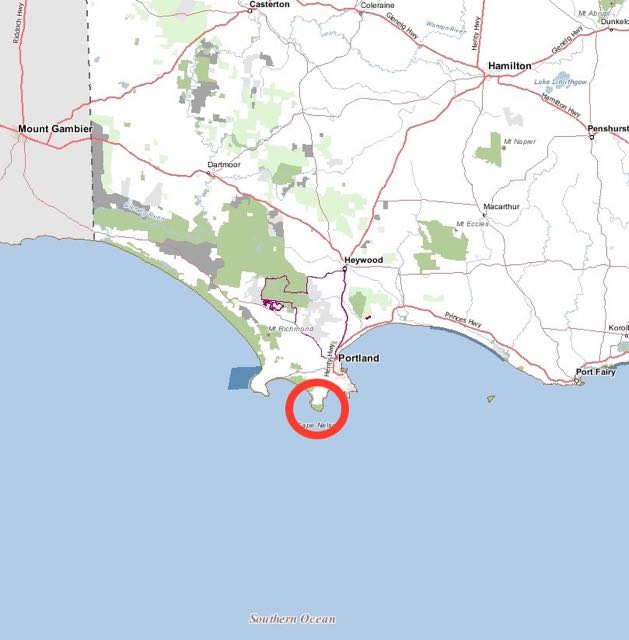
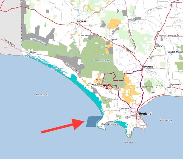
After unpacking the 4WD, we headed to our second park activation of the day, the Discovery Bay Marine National Park, VKFF-0949, situated about 20 km west of Portland in South Western Victoria and about 380 km west of Melbourne.  The park is part of a system of 13 Marine National Parks and 11 Marine Sanctuaries in Victoria.


Screenshot 2015-12-03 22.24.08

Above:- Map showing the location of the park.  Courtesy of Forest Explorer.

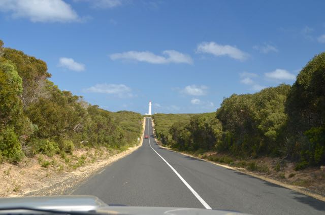
We travelled west out of Portland on the Bridgewater Road and then took Knights and Parkers Road.  We then turned left onto Kitson Road and then right onto Discovery  Bay Road.  This is a no through road which leads to a small parking area overlooking the ocean.  From here there is a walking track which takes you down to the beach and the northern most part of the Discovery Bay Marine National Park.

DSC_0192

Another option is to take Amos Road, which again is a no through road, but maps show that there is a walking track down to the beach at that location as well.  A little further to the south is Peacocks Road but it appears there is no access to the beach from there.  Blowholes Road is further to the south, however, the Marine National Park is quite some distance off shore at this point.

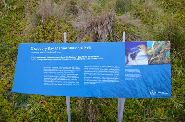
The park which was established in November 2002, is Victoria’s marine gateway to the Great Australian Bight and the immense expanse of the Southern Ocean.  The park protects part of the largest coastal basalt formation in western Victoria.  The park is framed by the cliffs of Cape Bridgewater to the east and the white sand dunes of Discovery Bay to the north.  The park covers 2,770 hectares adjacent to Cape Bridgewater along the coast from Blacks Beach to Whites Beach and offshore to three nautical miles, the limit of Victorian waters.  Between Whites Beach and Cape Duqesne, the park boundary commences 500 metres from the coastline.

Screenshot 2015-12-03 23.13.14

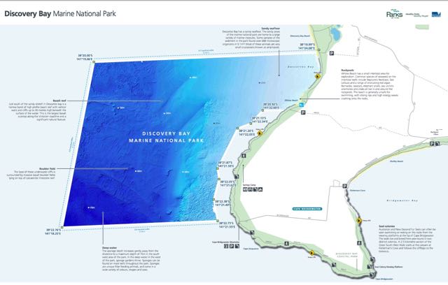
Above:- Map showing the Discovery Bay Marine NP.  Courtesy of Parks Victoria.

There is a rich diversity of marine life within the park due to the cold, nutrient rich waters of the area.  Southern Rock Lobster and the very rare Southern Hooded Shrimp are found here, and the waters also support Great White Sharks and during the summer breeding season, Blue Whales.  Other inhabitants of the waters include Fur Seals and dolphins.

Birdlife here is amazing and includes Australasian Gannets, Pacific Gulls, Common Diving Petrels, and Wandering Albatrosses.

A natural occurrence called the Bonney Upwelling is the cause for the nutrient rich waters.  This occurs when cold, nutrient rich water is brought up from the ocean floor and in turn these nutrients trigger the growth of microscopic plants, which form the building blocks of the complex food web.   Creatures such as Blue Whales feed on swarms of crustaceans known as krill and sponges filter tiny invertebrates from the water. Sharks, seals, gannets and many other animals feed on the schools of fish also benefitting from the nutrient rich waters.  Upwelling events like this only cover 1% of the ocean surface worldwide, and this is the only deep water upwelling event which occurs in Australian waters.

The average depth of the water in the park increases gently, away from the shoreline, to a maximum depth of around 75 metres in the south west area of the park.  In the deep water in the west of the park, sponge gardens thrive.  Sponges, which can be found on most reefs throughout the park, are unique filter feeding animals, and come in a wide variety of colours, shapes, and sizes.

DSC_0236

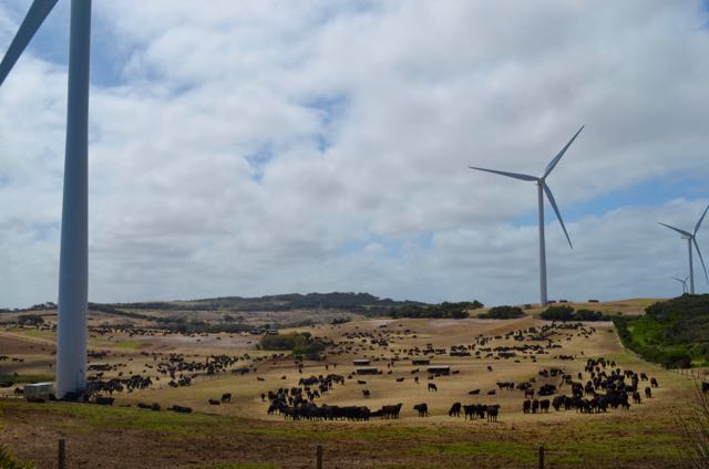
Nearby is the Cape Bridgewater Wind Farm, which powers around 35,000 Victorian homes every year.  The wind farm was completed in 2008 and comprises 29 wind generators.

DSC_0211

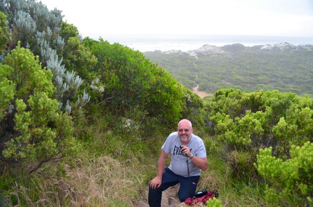
Upon reaching the end of Discovery Bay Road, we parked the car, and packed up the gear into our backpacks.  As I mentioned there is a carpark here, but you are a bit over the 100 metre allowable distance in the World Wide Flora Fauna program for Marine National Park operation.  So to play it safe, we decided to walk down the track a bit through the sand dunes, closer to the water.

The track leading down to the beach looks a lot worse than what it really is.  The walk down (and back up) is not all that bad.  Perhaps a little bit of a calf burner on the way up due to having to tramp through the sand.

DSC_0199

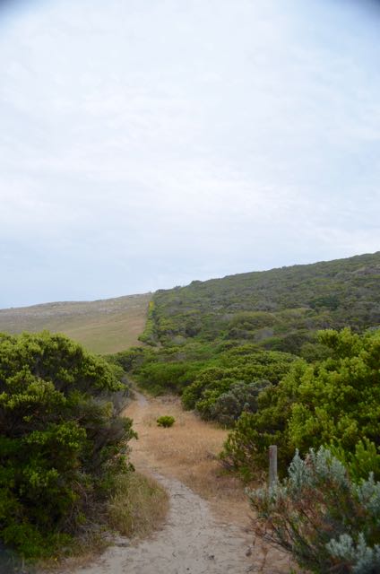
As we walked down the track, we noticed that there were a lot of native flowers out in bloom.  This is actually within the Discovery Bay Coastal Park which abuts the Discovery Bay Marine National Park.  A section of the Great South Walk also passes through here.

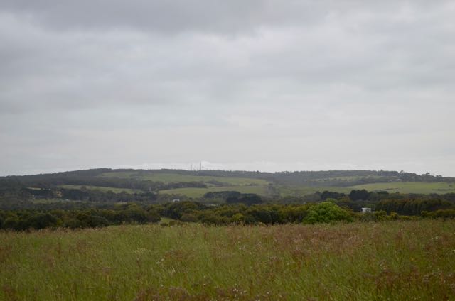
You are also rewarded with some nice views of the coast and the surrounding countryside.

This area of the coastline overlooks Descartes Bay in the Discovery Bay Marine National Park.  Descartes Bay has a sandy seafloor and is home to a large variety of marine creatures.  Some samples of the sediment in the park found over 688 microscopic organisms.  Most of these animals are very small crustaceans known as amphipods.

Screenshot 2015-12-03 22.21.30 (1)

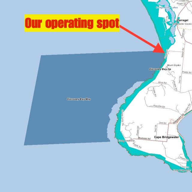
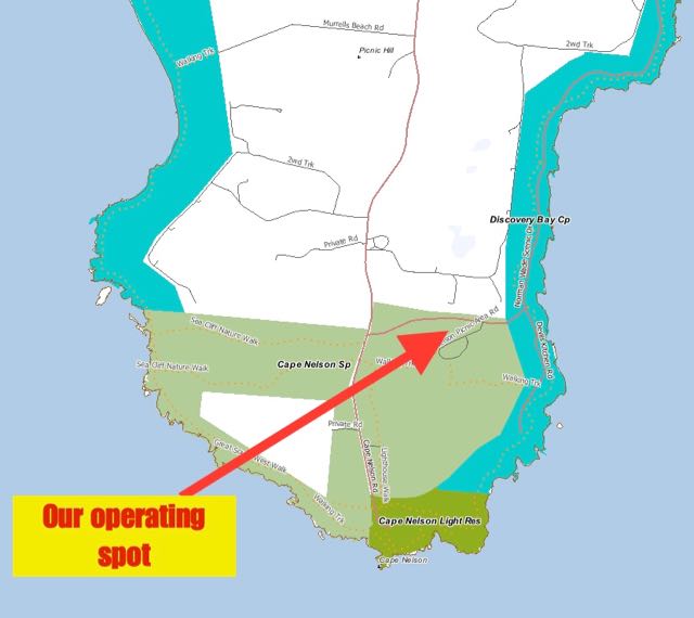
Above:- Map showing our operating spot.  Image courtesy of Forest Explorer

As we were not planning on being at the park for long, comfort didn’t come into the equation during this activation.  I propped on the track, changing positions from sitting to kneeling and avoiding sand and pants down the back of my tracksuit pants.

DSC_0207

After setting up I headed for my nominated operating frequency of 7.144 and called CQ.  This was answered by Ivan VK5HS who was mobile, followed by John VK5BJE, Mike VK3ZMD and then Brett VK2VW.  All had reasonable signals.  Certainly nowhere near as strong though as I normally hear John and Brett.  And my signal reports coming back from South Australia, Victoria, and New South Wales, were well down from usual.  But I was making contacts, and that’s all that counted.

I had quite a steady flow of callers during the activation, especially considering that this was a work day.   Callers on 40m were from South Australia, Victoria, New South Wales, Queensland, and Tasmania.  After working a total of 26 stations on 40m, I decided to try my luck on 20m.

My first contact on 20m was with Mr. Reliable, Rick VK4RF/VK4HA.  But despite numerous CQ calls and being placed on the DX Cluster by Rick, I had no more takers.  So tuned across the band and the only European signal that I heard was SV3AQR calling CQ, and he was not strong at all.  It was a little too early for Europe to be coming in on the long path.

I briefly joined the ANZA DX Net on 14.183 and worked two VK4’s there and my mate Ted VK6NTE who had his normal big signal.  But the Net soon wrapped up, and as their was not much activity on 20m, I decided to head back to 40m and put out more CQ calls, hoping to reach my 44 QSO threshold.  I had 31 contacts in the log, and just needed another 13 contacts to get there.  I went back to 7.144 and called CQ and this was answered by Barry VK5BW, followed by Rob VK3FENV, and then Ian VK1DI.

Unfortunately I started suffering from major QRM from a VK Net on 7.146 and I was forced to QSY.  I went down the band to 7.098 and worked a further 9 stations in VK2, VK3, VK5 and VK7.

It was now just a little after 4.00 p.m. Victorian local time, and I had a total of 49 contacts in the log.  I was happy as I had qualified the park for WWFF.

Marija and I took a brief stroll down to the beach, and then climbed back up the track through the sand dunes, back to the 4WD.


Thanks to Rick VK4RF for spotting me on the DX Cluster, and the VKFF & SOTA Facebook page.

The following stations were worked:-

  1. VK5HS/m
  2. VK5BJE
  3. VK3ZMD
  4. VK2VW
  5. VK2HHA
  6. VK5AKH
  7. VK3PF
  8. VK2NEO
  9. VK5NRG
  10. VK5WG
  11. VK7LTD
  12. VK3PMG
  13. VK3MRH
  14. VK3FINE
  15. VK3BY
  16. VK7CW
  17. VK2PKT
  18. VK5MBD
  19. VK5PL
  20. VK5CZ
  21. VK5FBAC
  22. VK3GQ/5
  23. VK4RF
  24. VK4HA
  25. VK5FANA
  26. VK5BGN
  27. VK5BW
  28. VK3FENV
  29. VK1DI
  30. VK7FRJG
  31. VK3MCX
  32. VK2IO
  33. VK5LG/p
  34. VK5HOS
  35. VK3FSPG
  36. VK5ND
  37. VK5VRT
  38. VK3TKK
  39. VK5FTVVR
  40. VK7NWT
  41. VK2MOR
  42. VK2JAZ
  43. VK5GI
  44. VK5KKT

The following stations were worked on 20m SSB:-

  1. VK4RF
  2. VK4HA
  3. VK4CC
  4. VK6NTE
  5. VK4LJ

After the activation, we drove down the Bridgewater Road and then on to Blowholes Road, to have a look at the southern section of the park.  There are some nice walks here and a number of interpretive signs.  One of the walks we undertook was to have a look at the ‘Petrified Forest’.  The formation is a collection of hollow tubes of limestone called ‘solution pipes’, eroded by millions of years of rainfall.


References.

Parks Victoria, 2015, <http://parkweb.vic.gov.au/explore/parks/discovery-bay-marine-national-park&gt;, viewed 3rd December 2015