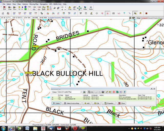
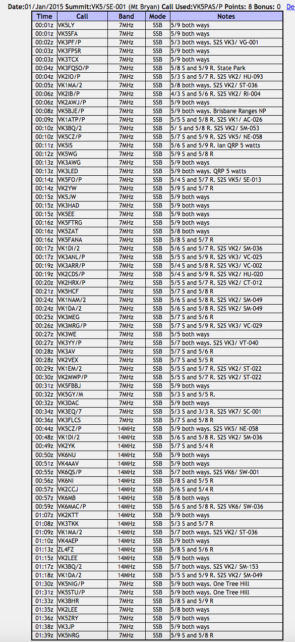
Recently Larry VK5LY did some research on his mapping system re VK5/ SE-016, the summit down on the Fleurieu Peninsula, near Delaware. The summit is un-named on the Summits on the Air (SOTA) database. However, the actual name of the summit is Black Bullock Hill.
map courtesy of mapcarta.com
This morning I contacted the Delamere General Store who put me in contact with the land owner that the summit is located on. In turn I contacted Mr. Peter Filsell. He confirmed that the summit was called Black Bullock Hill, but he was not aware as to why it was called this. Peter stated that his family had owned the land for about 60-70 years, but he had never been told the origins of the name. There is a road just to the south of the summit called Black Bullock Road and there is also Black Bullock Creek.
map courtesy of mapcarta.com
Peter was very friendly. Next time I am down that way I am going to call in to say g’day to Peter. There is no need to access Peter’s property, as the trig point is just a short distance from the road, and the roadway is well and truly within the activation zone. However, should you wish to operate from the trig point, you can contact Peter. Please do not enter the land unless you have Peter’s permission. I have placed Peter’s contact details on the SOTA page for this summit.
I have also advised Ian VK5CZ, the VK5 SOTA Association Manager, with a view to advising the SOTA moderators of the name of this summit, so that the records can be ammended.
There is also a Geocache at this site. Peter was unaware of this.
On Wednesday afternoon, my wife Marija and I headed north after finishing work in the city of Adelaide. Our destination was Burra, about 160 km north of Adelaide, in the Mid North of South Australia. Our intention was to activate Mount Bryan summit for the UTC rollover for the New Year. In the Summits on the Air (SOTA) program, activators are awarded points for activating a summit every calendar year. So this was a unique opportunity to get to the top of Mount Bryan and be awarded the 8 SOTA activator points for 2014, and then a further 8 activator points for 2015, when the new UTC day ticked over (10.30 a.m. South Australian local time).
map courtesy of mapcarta.com
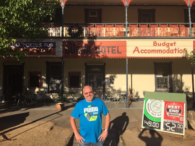
Our accomodation for the night was the Burra Hotel. This little pub offers affordable accomodation. Although not The Ritz, the room was clean and tidy, and the hotel staff were very friendly. I stayed here back in 2013 when I last activated summits in the area. After booking in, we had a walk around the Burra township, which is a pastoral centre and historic tourist town. Burra actually commenced its life as a single company mining township, that by 1851 was a set of townships collectively known as ‘The Burra’. The Burra mines supplied about 89 % of South Australia’s copper, and about 5 % of the world’s copper for about 15 years.
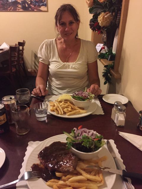
Unfortunately they were not serving meals at the Burra pub, so that night we had a meal at another one of the hotels in Burra, the Commercial Hotel. The meal there was very well priced and my rump steak was cooked to perfection. After our meal we retired to the main bar and chatted with some of the locals, whilst enjoying a few Bundy and cokes, and watching the 20-20 cricket at Adelaide Oval. We were in bed before midnight. Maybe that is a sign of us getting old. God help me when I’m 60!
For more information on Burra, please have a look at ‘The History of Burra’ website at…..
Back to some info on the Mount Bryan summit. Mount Bryan is 933 metres ASL and is worth 8 SOTA points. It is located in the South East Region of the South Australian SOTA Association. Mount Bryan is the highest summit in that Region. It has previously been activated by myself, Ian VK5CZ, John VK5BJE, and Bob VK5FO.
I last activated Mount Bryan summit in July 2013. For information on that activation, please have a look at my previous post…..
The famous Heysen trail heads up to the summit from Mount Bryan East Road. This is about a 2 hour walk. And it was a hot day. Armed with some prior information, and before heading north I contacted the Wildongoleechie Hotel at Hallett, and spoke to the owner, Marie. Via Marie, I got in contact with the land owner of the property, on which the road leading to the top of the summit is situated on. I subsequently contacted Tony and he confirmed that we could access the summit via his property. Contact details for Tony can be found on the SOTA notes for VK5/ SE-001.
After leaving Burra, Marija and I travelled north along the Barrier Highway, through the little township of Mount Bryan and then on to Hallett. We then turned right onto North Terrace and then onto Mount Bryan East Road. We travelled north along Mount Bryan East Road and reached the intersection with Scrub Road. We took a sharp right to continue along Mount Bryan East Road for a number of km. Rather than turning right onto the required road, Banbury Road, we continued along Mount Bryan East Road. We were lost. Oh, sorry Marija…I was lost!
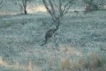
As we travelled along Mount Bryan East Road, we encountered numerous Western Grey kangaroos. So it was slow going. And we also saw a cheeky fox on the road, who wasn’t keen to move.
Fortunately we came across a fantastic farmer, who gave us directions and pulled me out of my dilema and frustration. So, please look out for Banbury Road which runs off Mount Bryan East Road.
This slideshow requires JavaScript.
As you travel along Banbury Road you will see a gate on the southern side of the road, which warns that the land is private property. Please do NOT enter the land unless you have the permission of the land owner. We then followed this dirt track, up through some gates, to the summit. The track leading to the summit is not passable for a conventional vehicle. A 4WD vehicle is definitely required as there are lots of washaways.
This slideshow requires JavaScript.
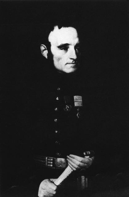
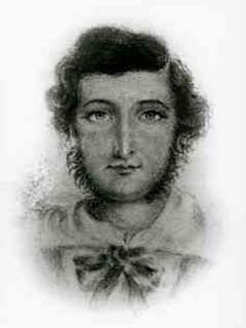
The very first European to sight what is now known as Mount Bryan was the explorer, Edward John Eyre (1815-1901). He explored the area in July 1839.
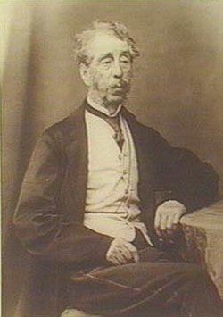
Above- Edward John Eyre. Courtesy of wikipedia.org
The area was next explored in December 1839, by Lieutenant-Colonel George Gawler (1795-1869) the second Governor of S.A. & Captain Charles Sturt (1795-1869), and their party. This included a young man called Henry Bryan, in whose honour, Gawler named the summit.
Above- Cptn Charles Sturt & Gov Gawler. Courtesy of wikipedia.org
In 1842, the Colonial Surveyor, Lieutenant Edward Frome (1802-1890) , further explored the area and he erected a cairn on the summit. He is reported to have been the first European to have climbed the summit. Frome later visited the area, at which time he climbed the summit and made a number of sketches.
Above- Edward Frome. Courtesy of wikipedia.org
Below is a sketch of Mount Bryan by Frome.
courtesy of ebooks.adelaide.edu
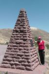
It never ceases to amaze me, the stupidty of some people and organisations. And here is another very sad example. Mount Bryan summit later became a Government Water Reserve and in 1970, the S.A. Water Authority demolished Frome’s historic cairn, to make way for other engineering works. A piece of South Australia’s history gone forever!
But there are always saviours. In 2002, Glen Tiver, erected the current cairn in memory of his forebears and early explorers. Tiver’s forebears owned the property called ‘Rupera’, which encompassed Mount Bryan and its environs.
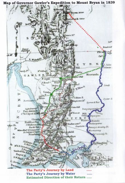
In December 1839, Governor Gawler and Captain Charles Sturt set out ‘to examine the land along the Murray river, with the hope of finding fertile country; and also to determine the capabilities of river and lake for inland navigation’. We know a lot about this expedition due to the efforts of Sturt’s biographer, Beatrix Sturt, who was also Sturt’s daughter in law. Sturt informed her directly re the expedition, and she also had access to all of his private papers.
The expediiton was first discussed by Gawler and Sturt in November 1839. They proposed to cross Lake Alexandrina from Currency Creek, near the present town of Goolwa. They were to proceed up the Murray to the Great Bend, and then return overland to Adelaide. The expedition party consisted of Governor Gawler, his 15 year old daughter Julia, Captain Charles Sturt and his wife Charlotte, Eliza Arbuckle who was Charlotte Sturt’s maid servant, Henry Inman Superintendent of Police, Henry Bryan a house guest of Gawler, WIlliam Pullen the Colonial Marine Surveyor, ArthurGell who was Gawler’s Personal Secretary, John Craig Aide to Gawler, Isaac Hearnshaw Aide to Gawler, and local aboriginal interpreters.
The Party set off from near present day Goolwa, and sailed in 4 little boats across Lake Alexandrina from Currency Creek, and proceeded up the Murray River to current day Morgan. After their arrival on Tuesday, the 10th December, at what was described as the ‘Great bend’ in the river at Morgan, they set up camp at the entrance of Bryan (Burra) Creek. The following day on Wednesday the 11th December, Gawler, Sturt, Inman, Craig, and Bryan, set off on horseback with a week’s provisions and 2 barrels of water to explore the country.
It was at approximately 12 noon on the 11th December, 1839, on a small hill to the north east of the campsite, that Gawler saw a mountain in the distance and immediately named it Mount Bryan after his young friend, Henry Bryan.
However by the first night, when about ’32 miles’ from the river, it was discovered that the barrels had leaked and much of the water had evaporated in the extreme heat.
A second day of extreme weather left barely a trace of water in the barrels and the situation was critical. Smoke was seen in the vicinity of Mount Bryan and the Party assumed that this indicated the presence of aboriginals, and thus water. Gawler later stated:-
“While contemplating the scene about us, smokes were observed to arise on Mount Bryan. Smokes indicate Natives, and Natives indicate the neighbourhood of water. Our casks had leaked, the bung had escaped from one of them, and the consequence was that our stock of water was just exhausted…..On the following morning, leaving Captain Sturt and Mr H Bryan in charge of our provisions and packhorses, I and Mr Inman set out in search of the Natives and water, but after toiling over the spurs and through the gullies during the morning of another hot day we could not find either. We found an extinguished Native fire and a ruined Native hut, but that was all, and we returned to the party to say that no alternative remained but to press through the night for our station on the Murray….”
It was at this time that Sturt bled one of the remaining three horses and all partook in this desperate attempt at survival.
On Friday the 13th of December, with all of their water gone and the temperatures rising, Sturt recommended that Gawler and Bryan set off on the strongest horses to seek help. They were about ’65 miles’ (110 kms) from the camp on the river. It was organised that Sturt, Inman, and Craig would follow a short time later.
On Saturday the 14th of December, Gawler and his horse could not proceed any further due to the heat and lack of water. Gawler and Bryan then swapped horses so that Bryan could ride the Governor’s horse slowly for the remaining ’12 miles’ to the camp, and Gawler would ride ahead.
By Sunday the 15th December, Gawler had reached the camp, however he had lost sight of Bryan at this time. He was followed soon after by Sturt, Inman and Craig. But there was no sign of Byran.
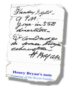
On Monday the 16th with the assistance of a local aboriginal, the group tracked the hoof prints of Bryan’s horse, about ‘five miles’ through the bush. They located Bryan’s blankets, coat, and stockings, and Gawler’s saddle, bridle, and telescope. On a scrap piece of paper, dated 9 p.m. Sunday 15th, Bryan had written that he ‘had been detained by exhaustion‘ but was going to the south-southeast.
“A second careful search at this spot disclosed the tree to which he had tethered his horse. The animal on escaping had taken a course due west to the hills with his rope trailing after him, and he eventually found his way back to Adelaide. But not search could disclose even to a native’s piercing eye any footprint or other mark in the direction indicated. Repeated efforts were made; they examined every bush, fired at intervals, constantly shouted; but to no purpose, nor was any further trace of ‘Bryan’ ever found”.
Bryan’s horse amazing eventually made its way back to Adelaide, with its hoofs grown to enormous lengths. And as for Bryan, he was never seen again, and has not been declared missing or presumed dead, nor has a death certificate been issued.
Gawler later wrote:-
“I never had so deep a regard for any young man that I had known for the same length of time, his character, looking at it with the severity of a Christian eye, was more faultless that that of any other individual of the same age”.
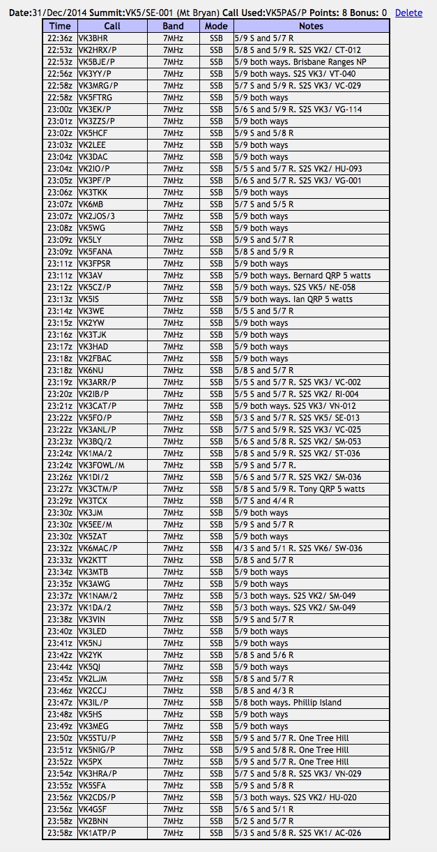
Marija and I set up the gear at the trig point. Or what is left of the trig point. There are now just three 1.5 metre high metal poles, painted bright blue. I used one of the poles to secure my 7 metre squid pole to, with the use of a few octopus straps. For this activation I used my Yaesu FT-857d, and ran 30 watts. The antenna was the 40m/20m linked dipole.
Prior to calling CQ, I had a look around the 40m band, and worked a few Summit to Summit stations including Compton VK2HRX on VK2/ CT-012, Glenn VK3YY on Spjon Kopje VK3/ VT-040, and Marshall VK3MRG on Briarty Hill VK3/ VC-029. I also tracked down John VK5BJE who was portable in the Brisbane Ranges National Park in Victoria.
I then proppped on 7.085 and called CQ and this was answered by Tom VK5FTRG in Millicent, and then Rob VK3EK who was portable on Fainting Ridge, VK3/ VG-114. I went on to have 69 QSOs prior to the UTC rollover. This included 21 Summit to Summit contacts before the UTC rollover.
My first contact after the UTC rollover was with Larry VK5LY in The Riverland. This was followed by Steve VK5SFA, and then Peter VK3PF who was portable on SOTA peak VK3/ VG-001. I went on to work a total of 72 stations after the UTC rollover. This included 26 Summit to Summit contacts.
This slideshow requires JavaScript.
During this activation I worked a total of 23 unique summits in VK1, VK2, VK3, VK5, VK6, & VK7:-
VK1/ AC-026, Booroomba Rocks
VK2/ CT-012
VK2/ HU-020
VK2/ HU-093, Mount Elliott
VK2/ RI-004, Mount Jergyle
VK2/ SM-036
VK2/ SM-049, Mount Tumanang
VK2/ SM-053
VK2/ ST-022 Wyanbene Caves Mountain
VK2/ ST-036, Spring Hill
VK3/ VC-002, Mount Donna Buang
VK3/ VC-025, Mount Dandenong
VK3/ VC-029, Briarty Hill
VK3/ VG-001, Mount Cope
VK3/ VG-114, Fainting Range
VK3/ VN-012, Mount Despair
VK3/ VN-029 Federation Range
VK3/ VT-040, Spion Kophe
VK5/ NE-058, Mount Ngadjuri
VK5/ SE-013, Mount Gawler
VK6/ SW-001, Bluff Knoll
VK6/ SW-036, Mount Dale
VK7/ SC-001
The following activators were worked:-
Paul VK1ATP/p
Andrew VK1DA/2
Ian VK1DI/2
Mark VK1EM/2
Matt VK1MA/2
Andrew VK1NAM/2
David VK2CDS/p
Compton VK2HRX/p
Bernard VK2IB/p
Gerard VK2IO/p
Andrew VK2MWP/p
Nick VK3ANL/p
Andrew VK3ARR/p
Andrew VK3BQ/2
Tony VK3CAT/p
Rob VK3EK/p
Rik VK3EQ/7
Allen VK3HRA/p
Marshall VK3MRG/p
Peter VK3PF/p
Glenn VK3YY/p
Ian VK5CZ/p
Bob VK5FO/p
Anthony VK6MAC/p
Matt VK6QS/p
After a total of 2 & 1/2 hours on the summit, I had a total of 146 contacts in the log on 40m ssb and 20m ssb. I had 69 contacts before the UTC rollover and then a further 72 contacts after the UTC rollover. I also managed a total of 47 Summit to Summit contacts, with a total of 260 S2S points. Of the 18 alerts on SOTAWatch for pre UTC rollover, I managed to make contact with 13. And there were 5 alerts for activations after the UTC rollover. I managed to work 3 of those. There were many other activators who did not place an alert on SOTAWatch, that I was fortunate enough to get in the log.
This activation was a lot of fun and I will certainly try to activate another summit this year for the New Year rollover. After getting down from Mount Bryan, we headed for the WIldongoleechie Hotel, but sadly it was closed. So instead, we travelled back into Burra and had a feed at the Royal Exchange Hotel. Again, this was an excellent meal at a very good price.
The following stations were worked before the UTC rollover:-
The following stations were worked after the UTC rollover:-
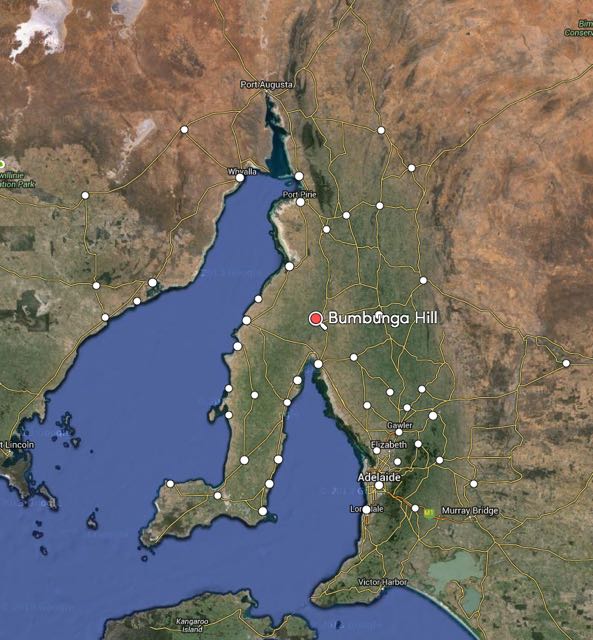
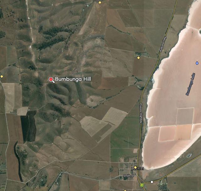
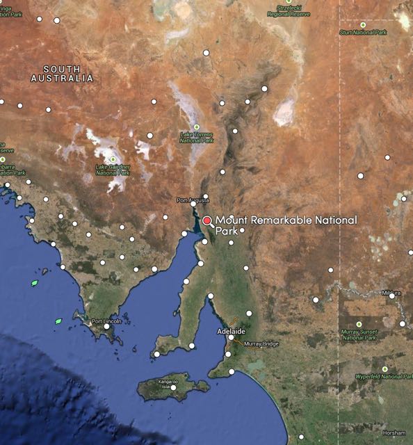
On Sunday morning (28th December 2014), Marija and I had intended on activating Mount Remarkable, VK5/ NE-010. But to be honest, we were quite exhausted from the 10 km walk the day earlier, when we had activated The Battery, VK5/ NE-055. So we chose an easier option. We were heading south back home, which would take us passed Illawarra Hill, Bumbunga Hill and South Hummocks. I tried calling the owner of the land that Illawarra Hill is located on, but could not get through. So I tried the land owner for the next summit south, Bumbunga Hill. John agreed there was no problem. So after packing our gear, that is where Marija and I headed…..Bumbunga Hill, VK5/ SE-015.
Bumbunga Hill is located near the town of Lochiel, in the Mid North of South Australia, about 130 km north of Adelaide, on the Augusta Highway. Bumbunga Hill is 413 metres ASL and is worth 1 SOTA point.
Map courtesy of mapcarta.com
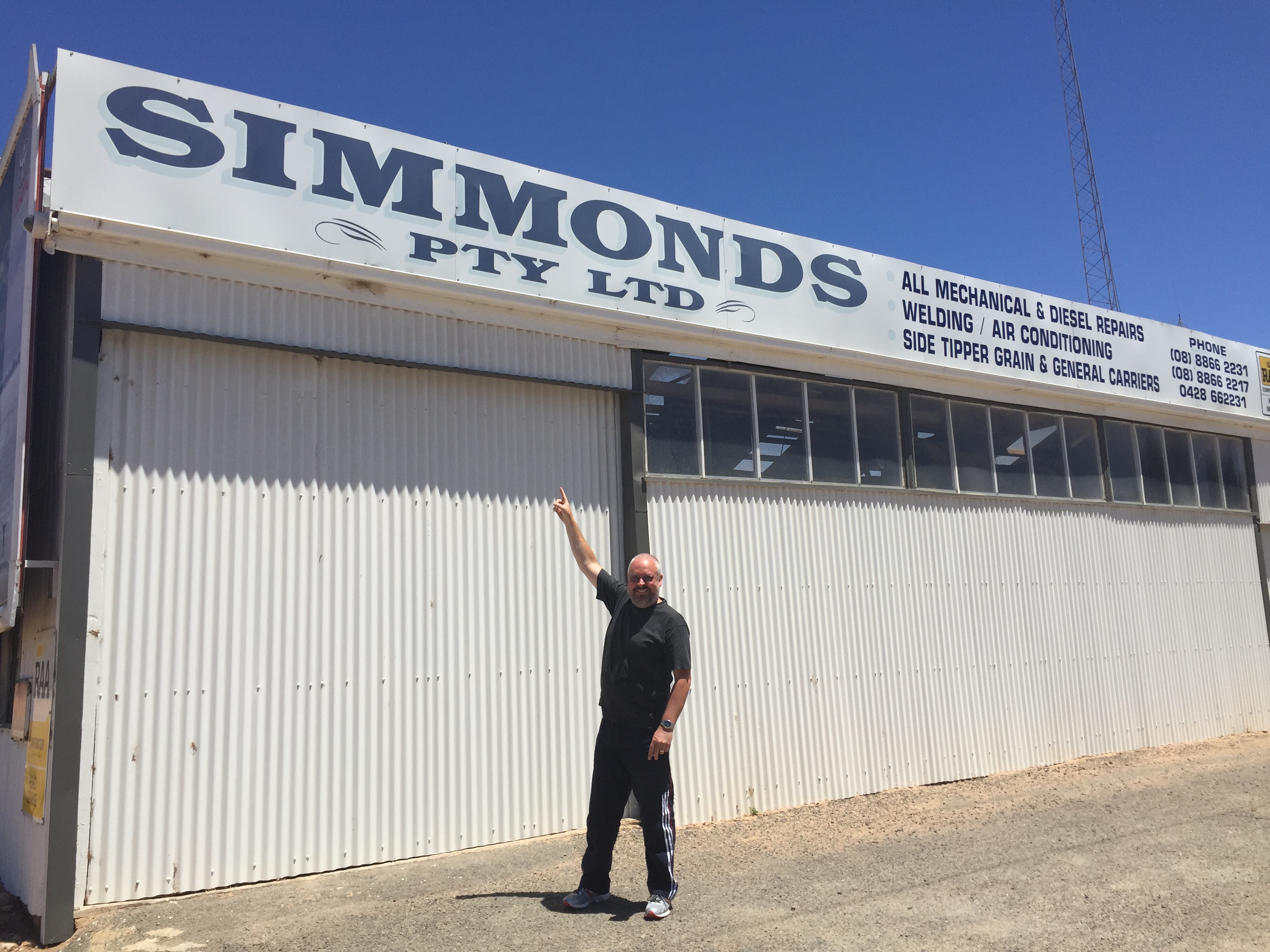
The summit is located on private property, so PLEASE obtain permission before entering onto the summit. Details of the owner can be located on http://www.sota.org.uk. Access is via Landslide Road, which runs off Smith Street. Smith Street is located on the western side of the Augusta Highway. I can never miss that street because on the corner is a business sharing my sirname….
The land owner, John was kind enough to unlock the main gate for us. At this entrance point you will see a shed and an old house ruin set back in the paddock. If you see them, you are at the right gate. However, access is not possible unless you contact John first. In any event, the gate is normally locked. We continued along the dirt track leading to the summit, passing throug a few more gates in the paddocks. The track becomes progressively more rocky and rough, with lots of washaways. I would not attempt this is in a conventional vehicle, but it is easily passable in a 4WD. Once we got close to the summit, we parked the car and walked the remainder of the way.
map courtesy of mapcarta.com
I last activated this summit in April, 2013. More information on that activation can be found at…..
I noted this time that the old trig point had been removed. All that is now left of where it once stood, are three blue painted upright poles. Just ideal to attach the squid pole to, with the assistance of some octopus straps. And for this activation I had a few of the creature comforts, including a fold up chair, courtesy of Marija.
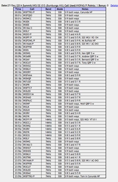
I managed to set up by 2353 UTC (10.23 a.m.) with only a few minutes to spare before the UTC ollover. In that short window, I managed to work 13 stations in VK1, VK3, & VK5. The first four contacts were with Larry VK5LY in The Riverland, Nev VK5WG in the Mid North, Matt VK1MA/3, and Col VK5HCF in Mount Gambier. I was also called by Andrew VK1NAM who was portable on Mount Stromlo, VK1/ AC-043. I was very pleased, my first summit to summit contact for the weekend. My final contact before the UTC rollover was Tom VK5FTRG who was portable in the Canunda National Park, in the South East of South Australia. This park qualifies for the World Wide Flora Fauna (WWFF) program and the VK5 Parks Award.
This slideshow requires JavaScript.
After the UTC rollover I worked a further 34 stations on 40m ssb in VK1, VK2, VK3, VK5, & VK7. This included a few more summit to summit contacts, including Peter VK3PF portable on VK3/ VE-154; and Andrew VK1NAM on Mt Stromlo VK1/ AC-043. I was also fortunate enough to work Julie VK3FOWL portable in the Mount Buffalo National Park, which qualifies for the Keith Roget Memorial National Parks Award (KRMNPA) and the World Wide Flora Fauna program (WWFF).
I then slipped up to 20m and worked a further 6 stations in VK2 and VK3. Conditions on 20m were not great, with lots of QSB present. But I did manage to sneak in another summit to summit. This time with Glenn VK3YY who was portable on SOTA peak Mount Tamboritha, VK3/ VT-011, which is also located in the Alpine National Park. So another KRMNPA and WWFF contact as well.
So after a little over an hour on the top of the hill, I had a total of 53 contacts in the log. It was getting hot, Marija was getting a little impatient (had read all her magazines), and I was getting hungry. So it was off to Port Wakefield for some lunch at the bakery.
Although Bumbunga Hill is only worth 1 point, the views from the top are spectacular. It has great take off in all directions. And access is easy. All in all a great summit. And again thanks to John, the land owner, who kindly allowed us access. We touched base with him again as we left the property, and he was very pleased we enjoyed the trip to the top.
Following our activation of the Whyalla Conservation Park, Marija and I continued on to the little town of Melrose, which is nestled below the impressive Mount Remarkable summit, in the southern Flinders Ranges. From Whyalla we travelled north to Port Augusta and then travelled south along Highway A1 (Augusta Highway). We then turned left onto Horrocks Pass Road/Main North Road, and travelled towards Wilmington.
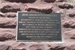
On the way to Wilmington we passed through Horrocks Pass, and we stopped off at the monument for John Horrocks, after which the pass was named. This is well worth a look. The story of Horrocks is a very interesting one. John Ainsworth Horrocks (1818-1846) was a pastoralist and explorer. In 1846, Horrocks led an expedition of 6, for a planned 4 month expedition to search for new agricultural lands near Lake Torrens. Between the 16th-19th August 1846, the expedition crossed the Flinders Ranges via Horrocks Pass. Horrocks and his team travelled with a camel, two carts, six horses, and twelve goats. Horrocks noted that the camel was very temperamental, often biting the humans and goats.
Image courtesy of images.slsa.sa.gov.au
However, the camel was able to carry up to 350 pounds (158.7 kg), which was vital for the anticipated trek across some very arid land. On September 1st, Horrocks was preparing to shoot a bird on the shores of Lake Dutton. While Horrocks was reloading his gun, the kneeling camel moved, which resulted in Horrocks catching the cock of the gun. The gun discharged, resulting in Horrocks loosing the middle fingers of his right hand and a row of teeth. Horrocks subsequently died of his wounds , about 3 weeks later, on September 23rd. And what of the naughty camel? Horrocks had ordered that it be shot.
Plenty of emus out here.
And kangaroos
The monument to John Horrocks
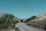
Horrocks Pass, looking west
After leaving the Horrocks monument, we continued east and detoured to Hancock’s lookout. This is well worth taking the 7 km drive on the dirt road from the bitumen. On the way we saw numerous emus feeding in the farmer’s paddocks. Fortunately, none of them ventured out in front of the vehicle. Hancock’s lookout offers spectacular views of Spencer Gulf and the Port Augusta area.
This slideshow requires JavaScript.
After Hancock’s lookout, we continued on to Wilmington and then travelled south on Horrocks Highway/Main North Road to Melrose. We had booked in to stay for one night at the Melrose cabins which are run by the Melrose Hotel. This is the second time we have stayed here, and we highly recommend the cabins. They are well priced, clean and comfortable.
This slideshow requires JavaScript.
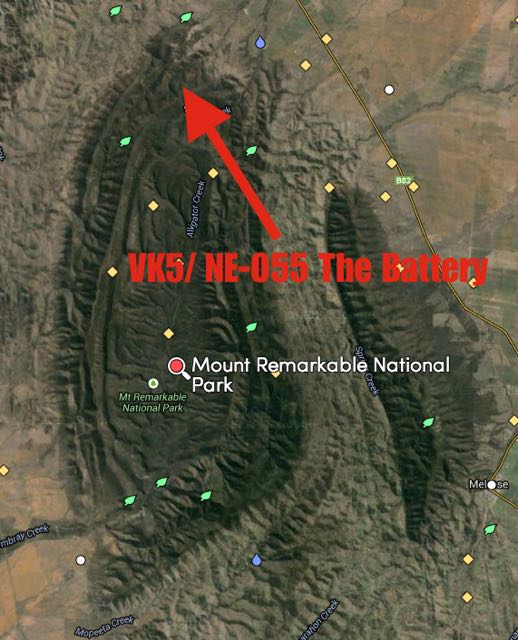
After lunch at the cabin, which consisted of schnitzel, roast potatoes, pumpkin, roast carrots, and salad, courtesy of my loving mother in law, we headed back out for our second activation for Saturday 27th December, 2014, which was The Battery, VK5/ NE-055, which is located within the Mount Remarkable National Park. So a triple whammy. A SOTA summit, a WWFF (VKFF) park, and a VK5 Parks award park.
Map courtesy of mapcarta.com
Marija and I travelled north along Horrocks Highway/Main North Road and then turned left onto Alligator Gorge Road and travelled south west until we reached the entrance to the Mount Remarkable National Park. We continued south west through the park until we reached Alligator Lodge which was on our left. Directly opposite is a campground, which is blocked off for vehicles. Look for Gate 5. There is also a sign here indicating that The Battery is 4.5 km away (the summit is a bit further). We parked the car on the south eastern side of the road and commenced the walk down the 4WD track towards the summit.
map courtesy of mapcarta.com
I would describe the walk as moderate but still quite taxing. The first 4 km involves a few inclines. However it is the last 1 km that is the hardest. There are some steep inclines and lots of rocks. The ground is very unsteady under foot. In many parts, the authorities have placed mesh to prevent slipping. But there are some spectacular views along the way, and once you reach the top, you are rewarded with a magnificent view of the surrounding countryside and Spencer Gulf. The track is quite well signposted.
Mount Remarkable National Park is located about 45 km north of Port Pirie. Access to the park is either via the Augusta Highway via Mambray Creek, via Melrose, or via Alligator Gorge (our route). A fee of $10.00 is charged for vehicular entry, which we paid the night before online. Please note, that park entry fees now need to be paid online prior to visiting the park. Cash payments are no longer an option in this park.
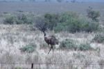
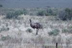
The park is 16,000 hectares in size and stretches from the coastal plain adjacent to Spencer Gulf, across the ranges, to Mount Remarkable on the edge of the Willochra Plain in the east. The park is full of kangaroos, Euros, Emus, and other wildlife.
The summit, Mount Remarkable, was named by explorer, Edward John Eyre in June 1840. The local aboriginal Nukunu people, refer to it was ‘Wangyarra’. The word ‘aara’ meaning running water. Alligator Groge and Mambray Creek were dedicated as National Pleasure Resports in 1952. These areas were added to and became managed by the National Parks Commission during the 1960’s. Following the enactment of the National Parks and Wildlife Act, 1972, Alligator Gorge, Mambray Creek and Mount Remarkable were proclaimed as the Mount Remarkable National Park. Additional portions of land have been added to the park since that time.
This slideshow requires JavaScript.
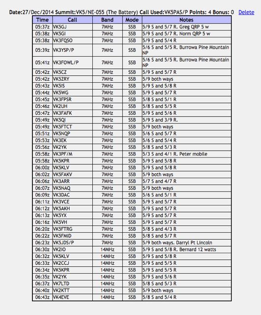
The Battery is 765 metres above sea level and is worth 4 points. This was the first time I had activated this summit. It had only been activated previously by Ian VK5CZ in June 2013 and April 2014.
For this activation I ran my little Yaesu FT-817nd, 5 watts and my 40m/20m linked dipole, supported on a 7 metre squid pole. Marija and I improvised and used a fallen tree branch to secure the squid pole to, with the assistance of some octopus straps.
My first contact was with Greg VK5GJ who responded to my ‘is the frequency in use’ call on 7.095. Greg was running QRP 5 watts but was a lovely 5/9 to the Flinders Ranges. In the shack with Greg was Norm VK5GI, also running QRP. This was followed by Amanda VK3FQSO, and then Joe VK3YSP and wife Julie VK3FOWL who were portable in the Burrowa Pine Mountain National Park. I always get a bit of a kick when I work a National Park activator, so it was great to get Joe and Julie in the log.
A steady flow of callers then followed from Vk2, VK3, & VK5. Conditions appeared to be reasonable, however there was a little bit of QSB on the 40m band. After working a total of 31 stations on 40m, I lowered the squid pole and removed the links for operation on the 20m band. My first contact on 20m ssb was with Gerard VK2IO who was portable at Gosford, running 12 watts from his Elecraft KX3. This was followed by Peter VK5KLV at nearby Port Augusta and then Cliff VK2CCJ. Cliff was pleased to get me in the log, as he told me that he was unable to hear me on 40m.
After a little over an hour on the summit, I had a total of 39 contacts in the log from VK2, VK3, VK4, VK5, & VK7 on both 40m ssb and 20m ssb.
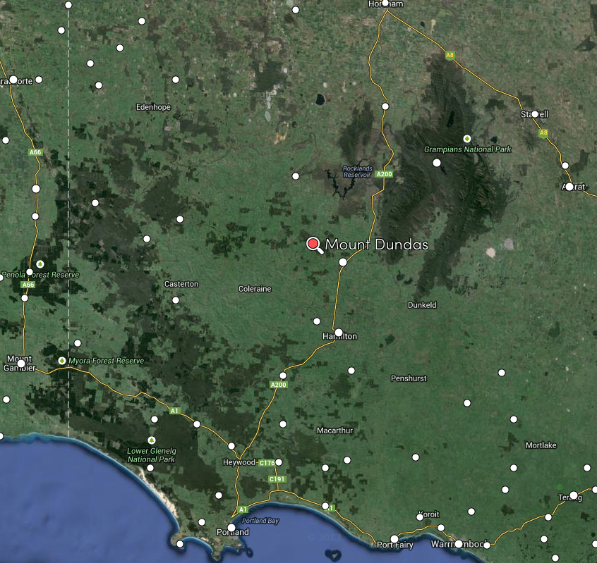
Mount Dundas, VK3/ VS-045 was my second activation for the Summits on the Air (SOTA) program for Monday 17th November, 2014. Mount Dundas is located about 309 km west of Melbourne, and about 16 km north west of the little town of Cavendish.
Image courtesy of mapcarta.com
Mount Dundas is 459 metres above sea level, and is worth just 1 SOTA point. It is an easy summit to access, with a dirt road, leading all the way to the top where there is a large array of telecommunications equipment, including a digital TV broadcast site. According to SOTAWatch I am the only operator to have activated this summit, which I’m a little surprised by considering the easy access.
Image courtesy of mapcarta.com
Access to the summit is via Dundas Gap Road, which runs off the Natimuk to Hamilton Road, just out of Cavendish. There is a dirt road leading to the summit which is suitable for 2wd vehicles. I parked the car a little down the dirt road, and walked a few hundred metres to the top of the summit, so that my final access into the activation zone was by non motorised means. I set up on the eastern side of the telecommunication equipment, and was pleasantly surprised when I turned the radio on to find that there was not a lot of interference from the conglomerate of antennas at the site. There really aren’t too many other options here, as the terrain drops away quite dramatically from the summit peak on all sides, and the surrounding scrub is very thick.
Map courtesy of mapcarta.com
As I left my car I heard Rob VK2QR operating from a summit, so I quickly set up my gear and gave Rob a call on 7.090. Rob was a good 5/8 signal and was sitting on the top of VK3/ VE-023, a 10 pointer in north eastern Victoria. I received a 5/8 signal report back from Rob. It appeared that the 40m band had improved since my activation at Mount Rouse. Amen to that!
Rob kindly gave me the frequency following our QSO, and it wasn’t long before I had a good flow of callers from VK2, VK3, & VK5. My second contact was with Peter VK3PF, followed by Bernard VK2IO, and my fourth qualifying contact was with Bernard VK3AV. It was certainly not as hard going as Mount Rouse, which was great. Although there was still a bit of QSB on the signals.
A few contacts later, I was called by John VK2AWJ/3 who was portable in the Burrowa Pine Mountain National Park, VKFF-069. John was a good 5/4 and I received a 5/5 signal report from John. This was followed by a contact with Rick VK3EQ, who was on top of McCarthy Spur, VK3/ VT-039, a 6 pointer. Although Rick’s signal was very weak (5/1), I was able to copy him without any difficulty.
I went on to work a further 14 stations on 40m. I didn’t try 20m as promised, as the weather was less than ideal, and I still had two planned park activations, and a big trip ahead of me to get back home to the Adelaide Hills. So I am sorry to any of the VK6’s.
This slideshow requires JavaScript.
After 35 minutes on the summit, I had a total of 26 contacts in the log, including two Summit to Summit (S2S) contacts and one Victorian National Park contact.
The following stations were worked:-
Below is a video of the activation…..
After getting mobile from the summit, I worked Rob VK2QR/2, who was portable on Mount Murray, VK3/ VE-025. I was just about to enter the little town of Cavendish when I spoke with Rob, who was a good 5/7 into the mobile (5/7 received from Rob).
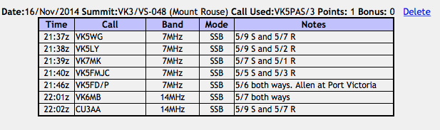
My first activation for Monday 17th November, 2014, was Mount Rouse, VK3/ VS-048, which is located near the town of Penshurst, about 275 km west of Melbourne, and about 30 km south east of Hamilton, in western Victoria.
Map courtesy of mapcarta.com
There are some activations, when you just wished that you had stayed in bed. This was one of those activations! Other than the weather being less than ideal (it was wet and windy), the 40m band was in very poor condition. I managed just 7 contacts from this summit. But out of everything bad, comes something good. To my surprise, I was called by a station in the Azores on 20m, who was 5/9 and gave me a 5/7 signal report. And yet I wasn’t even able to make contact with a single VK3 on 40 metres. I guess that is one of those interested aspects of this great hobby of amateur radio.
Map courtesy of mapcarta.com
I had activated Mount Rouse once before. That was back in September, 2013. For more information on that activation and information on the summit, including its history, please have a look at my previous post……
This is a very easy summit to access, with a road leading all the way to the top of the summit through the Mount Rouse Reserve. A set of steps takes you up to the trig point. Although only a little one pointer, this is a great little summit, with a bench awaiting you once you reach the trig point, and fantastic views of the surrounding countryside, and the little town of Penshurst below the summit.
On the subject of Penshurst, please take the time to have a look around this little town. It is full of history and as some very historic buildings. There is also the Volcano Visitor Centre which is well worth a visit.
As mentioned, the 40m band was in very poor shape. There was absolutely no propagation locally around VK3. I managed to squeeze 5 contacts into the log on 40m with Nev VK5WG who was my first taker, Larry VK5LY, Mark VK7MK, John VK5FMJC, and finally Allen VK5FD portable at Port Victoria. I did hear Peter VK3FPSR trying to call, but Peter was so weak, that it was impossible to make the contact.
So after 10 very frustrating minutes on 40m, I lowered the squid pole and removed the links in the linked dipole, for operation on the 20m band. My first contact there was with Mike VK6MB who was a good 5/7 (5/7 signal report received in exchange). And I then received a call from Joan, CU3AA, in the Azores Islands, in the North Atlantic Ocean, to the west of Portugal and the west African coast. Joan was an excellent 5/9 signal and he gave me a 5/7. But that was the end of that. I had no more callers on 20m.
This slideshow requires JavaScript.
As the weather was lousy, and the band was lousy, I decided to head down and head off to my next summit, Mount Dundas near Cavendish. I had the very low number of 7 contacts in the log. One of my worst SOTA activations as far as callers is concerned.
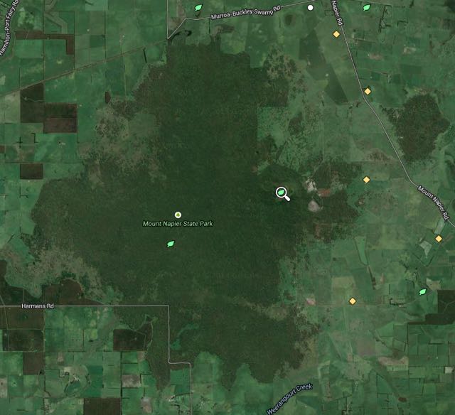
My first activation for Sunday 16th November, 2014, was Mount Napier summit, VK3/ VS-046, which is located near Hamilton in western Victoria (13 km south of Hamilton). This was my second activation for the 2014 Summits on Air (SOTA) Spring Activation Weekend.
Map courtesy of mapcarta.com
map courtesy of mapcarta.com
I first activated this summit in September, 2013. For more information on that activation, and some history of the summit and its surrounds, please have a look at my September 2013 post…..
I entered the Mount Napier State Park via Murroa-Buckley Swamp Road, which runs off the Hamilton-Port Fairy Road. The dirt road traversing the park is in good condition and is easily negotiated with a 2wd vehicle. I parked my car at the Mount Napier walking track, and commenced the 30 minute walk up to the top of the summit. This is a nice easy walk to the top, with a well marked path and a few benches along the way. The walk is spectacular taking you through the beautiful understorey of the Mount Napier State Park.
Following this activation I received an e-mail from Nick VK3ANL who stated:
“Mt Napier gets my vote for being “Essence of SOTA” – it’s a genuine walk to the top, but not too hard or long, and through some great Aussie bush, and then it opens out to a summit with real character, and with $million dollar views.”
I think Nick is spot on with his comments. Although only a one pointer, the walk up to the summit is very pretty and the views from the top of Mount Napier are really impressive.
map courtesy of mapcarta.com
The weather was not fantastic when I arrived at Mount Napier. It had been drizzling with showers from the time I got up. But there was the occasional break in the weather. So I ‘donned’ the jacket and my backpack, and headed off from the car, hoping to miss the worst of the weather. As mentioned, this is a really pretty walk. And I encountered a few wallabies on the way to the top/
On my way up, I received just a sprinkle of rain, but by the time I had reached the trig point, the weather had taken a turn for the worst. The summit itself is very exposed, with no trees, so it was incredibly windy, with light misty showers. I secured the squid pole to the concrete base of the Major Thomas Mitchell memorial which is located on the summit. It was so windy, it was quite difficult trying to keep the squid pole in place.
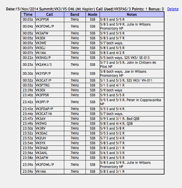
After setting up I put a CQ call out on 7.090 and this was answered by Rob, VK3EK, and then Peter VK3FPSR, followed by Peter VK3PF portable in the Coopracambra National Park. More information on Peter’s activation can be found on hsi WordPress site at…..
I then spoke with Darrin VK3FDAP operating portable and QRP at Moorabin. Thankfully I had my 4 qualifying contacts. I pressed on and worked a further 12 stations in VK1, VK2, VK3, & VK5 before the UTC rollover. There was very severe QSB on many of the signals. One of these contacts was with Julie VK3FOWL who was operating portable with her husband Joe VK3YSP, in the Wilsons Promontory National Park.
After the UTC rollover I worked a further 7 stations in VK1, VK3, & VK5. It was quite a struggle, with the band not in great shape. There was lots of QSB on the incoming signals, and the same was being reported back on my QRP signal. Gary VK2GAZ called me a number of times and although I was able to hear Gary, clearly he could not pull me out of the noise. Sorry Gary.
This slideshow requires JavaScript.
The weather had not improved, so I had a quick tune around the 40m band and found Nigel VK5NIG who was operating portable from the top of Mount Gawler summit, VK5/ SE-013. Nigel had a good 5/5 signal (5/5 received back from Nigel). I then found John VK2AWJ/3 operating portable from the Chiltern Mount Pilot National Park, with a good 5/7 signal coming in to Mount Napier. With a little bit more tuning around the band, I was rewarded with a contact with Joe VK3YSP, portable in the Wilsons Promontory National Park, and then Tony VK3CAT who was portable on SOTA summit, Sugarloaf Peak, VK3/ VN-011.
It was time to dash back to the car. I had a total of 28 contacts in the log.
The following stations were worked:-
Whilst still on my way out of the Mount Napier State Park, on my way to Mount Eccles National Park, I spoke with a few stations from my mobile set up, which is a Icom IC-7000 and a base loaded whip antenna on the boot of the car.
My first mobile contact was with Peter VK3ZPF who was portable in the Yarra Ranges National Park, then Peter VK3PF in the Alfred National Park, followed by Allen VK3HRA portable on SOTA peak VK3/ VG-029 which is located in the Alpine National Park.
Below is a video of the activation of Mount Napier…..
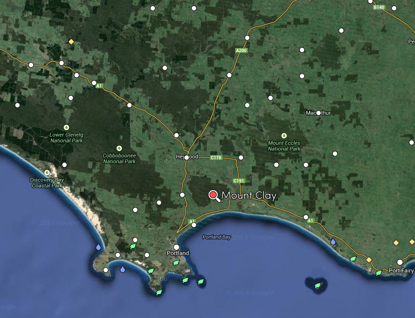
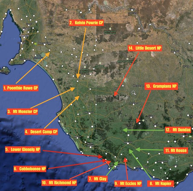
After activating Lower Glenelg National Park and Cobboboonee National Park, it was time for some action in the Summits on the Air (SOTA) program. After all, this was also the 2014 SOTA Spring Activation Weekend. So I headed to Mount Clay, VK3/ VS-051, which is located about 30 km north east of Portland.
Map courtesy of mapcarta.com
Mount Clay is 186 metres above sea level, and is worth just 1 SOTA point. It was first activated by VK3DEE in August, 2013, and has been activated a total of 5 times. Surprising really, because it is a very easy summit to access. The summit is a digital TV broadcast site, so there is a road leading all the way to the summit.
I called in to the Narrawong General Store for directions. Thanks to the very friendly people there, I found my way to the summit quite easily, via Mount Clay Road, then Tower Road, and then Angelino Road.
As the gate at the end of Angelino Road, has got a plethora of padlocks on it, I didn’t want to venture all the way to the trig point which was visible from the gate. Although there were no signs restricting access, I wasn’t 100 % sure, so I played it safe and set up at the gate. This is well inside the activation zone.
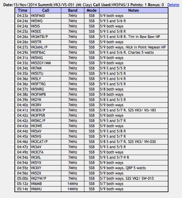
I tuned to 7.095 and started calling CQ SOTA and was greeted by Brian VK5FMID in Mount Gambier with a beautiful 5/9 signal. This was followed by Nev VK5WG in Cyrtsal Brook who was also 5/9, Ian VK5IS in the Beetaloo Valley, again 5/9, and then Tom VK5EE at Mount Gambier. I was pleased. I had my 4 qualifying SOTA contacts.
My 5th contact was with Tim VK3MTB who was portable in the Baw Baw National Park VKFF-020, as part of the 2014 KRMNPA Activation Weekend. And soon after this I was also called by another park activator. This time, Nick VK3ANL who was portable in the Point Nepean National Park, VKFF-628.
A steady flow of callers followed from VK2, VK3, VK5, & VK7. All had good signals and generally my signal with just the 5 watts appeared to making the journey to most parts of eastern and southern Australia.
This slideshow requires JavaScript.
My first Summit to Summit (S2S) contact was with Rob VK3EK who was portable on VK3/ VG-133. About 6 contacts later, I had my 2nd S2S with Tony VK3CAT who was portable on Mount Strickland, VK3/ VN-030.
After traffic had slowed on 7.095, I tuned down to 7.090 and found John VK2YW who was portable on Granite Mountain VK2/ SW-015. I gave John a call who was a good 5/7 signal to Mount Clay (5/7 received in return).
It was starting to get very dark, with rain threatening, and thunder & lightning nearby, so it was time for me to qickly lower the antenna and remove the links for 20m. I put out a CQ call on 14.310 and this was responded to by Mike VK6MB and then John VK6NU who had a very strong 5/9 plus signal coming in from Western Australia.
The rain was alomst here, so I quickly took down the gear and ran back down the road to car. Making it just in time, before the heavens opened up. I had a total of 34 contacts in the log.
Just as I had got back to the car I heard Rob VK2QR calling CQ from the top of SOTA peak, The Twins, VK3/ VE-017. I had just missed another S2S. But I did manage to make contact with Rob from the car (5/9 both ways).
I then worked Andrew VK1NAM/2 from the car. Andrew was on SOTA summit VK2/ SM-053, and then Peter VK3PF who was portable on SOTA summit, Monkeytop, VK3/ VE-041, which was also in the Snowy River National Park, VKFF-455. A new park for me. Yeeehhaa!
More information on Peter’s activation can be found on his WordPress site at…..
What a great 4 days I’ve just had. My wife Marija and my Boss at work gave me some ‘leave passes’ and it was off to Victoria for me, for the 2014 Keith Roget Memorial National Parks Award (KRMNPA) activation weekend, and the 2014 Summits on the Air (SOTA) Spring Activation weekend.
So I packed the car with my gear and headed off early on Friday morning, and returned Monday evening, covering over 1,500 km during my travels. On Friday I activated 4 SA Conservation Parks on the way to Victoria, and then on Saturday, Sunday and Monday I activated 6 Victorian National Parks, and 4 SOTA peaks. I based myself at Portland. I stayed at the Whalers Rest, which I can highly recommend.
I managed a total of 473 contacts whilst in a park or on a summit, and a further 13 QSOs whilst I was mobile. Most of those contacts were VK’s but I did manage about 30 DX contacts into Europe, UK, Pacific. I had just 8 summit to summit contacts, missing quite a few opportunities whilst either climbing or in transit.
Band conditions were excellent on Friday & Saturday, bu t then took a dive on Sunday & Monday, with lots of QSB. And absoultely no local (VK3) propagation on Sunday morning when I was on the top of Mount Rouse. But I did manage a contact into the Azores on 20m. Go figure!
Many thanks to Peter VK3PF, who I managed to work for my 3 remaining Victorian National Parks: Errinundra, Lind, & Snowy River. I’ve now managed to work all 45 Victorian National Parks and qualify for the Worked all 45 Victorian Parks KRMNPA certificate and the KRMNPA Merit plaque.
I worked the following activators in Victorian National Parks (a few a couple of times, when I had moved parks, or on different days, etc)…..
John VK2AWJ/3, Barmah National Park
Peter VK3TKK/p, Organ Pipes National Park
John VK2AWJ/3, Lower Goulburn National Park
Tim VK3MTB/p, Tarra Bulga National Park
Terry VK3UP/p, Brisbane Ranges National Park
Johnno VK3FMPB/p, Grampians National Park
John VK2AWJ/3, Warby Ovens National Park
Mike VK3XL/p, Churchill National Park
Nick VK3ANL/p, Mornington Peninsula National Park
Hiro VK3EHG/p , Yarra Ranges National Park
Tim VK3MTB/p, Baw Baw National Park
Nick VK3ANL/p, Point Nepean National Park
Peter VK3ZPF/p, Yarra Ranges National Park
Peter VK3PF/p, Alfred National Park
Peter VK3PF/p, Coopracamba National Park
Julie VK3FOWL/p, Wilsons Promontory National Park
John VK2AWJ/3, Chiltern-Mount Pilot National Park
Joe VK3YSP/p, Wilsons Promontory National Park
Peter VK3PF/p, Lind National Park
Peter VK3ZPF/p, Churchill National Park
Amanda VK3FQSO/p, Terrick Terrick National Park
Allen VK3HRA/p, Morwell National Park
John VK2AWJ/3, Burrowa Pine Mountain National Park
Thankyou to all of the activators. I really appreciate your efforts, as I know the weather conditions were less than ideal, and band conditions were very challenging at times.
And I worked the following SOTA activators (a few a couple of times with the UTC rollover and when I had moved parks, etc)…..
Rob VK2QR/3, Mount Hotham VK3/ VE-006
Andrew VK1NAM/p, VK2/ SM-036 and Kosciuszko National Park
Rob VK3EK/p, Mount Cann VK3/ VG-133
Peter VK3FALA/p, Mount Elizabeth VK3/ VG-074
Nick VK3ANL/p, Arthurs Seat VK3/ VC-031
Ian VK3TCX/p, Mount Elizabeth VK3/ VG-074
Fred VK3DAC/p, Mount Toolebewong VK3/ VC-033
Ron VK3AFW/p, Arthurs Seat VK3/ VC-031
Andrew VK1NAM/2, Blackfellows Hill VK2/ SM-033
Phil VK3BHR/p, Mount Alexander VK3/ VN-016
Rob VK2QR/p, Mount Lock VK3/ VE-005 & Alpine National Park
Amanda VK3FQSO/p, West of England Fire Tower VK3/ VW-016 & Kara Kara National Park
Bernard VK2IB,VK2/
Peter VK3PF/p, Mount Ellery VK3/ VG-153 & Errinundra National Park
VK3FCAT, Mount Vinegar VK3/ VC-005
Rob VK3EK/p, Mount Cann VK3/ VG-133
Tony VK3CAT/p, Mount Strickland VK3/ VN-030
John VK2YW/p, Granite Mountain VK2/ SW-015
Rob VK2QR/p, The Twins VK3/ VE-017
Andrew VK1NAM/2, VK2/ SM-053
Peter VK3PF/p, Mokeytop VK3/ VG-041 & Snowy River National Park
Allen VK3HRA/p, Mount Seldom Seen VK3/ VG-029 & Alpine National Park
Nigel VK5NIG/p, Mount Gawler VK5/ SE-013
Tony VK3CAT/p, Sugarloaf Peak VK3/ VN-011
Nick VK3ANL/p, Mt Dandenong VK3/ VC-025 & Dandenong Ranges National Park
Reuben VK7FREU/p, Mount WellingtonVK7/ SC-001
Rob VK2QR/3, Sam Hill VK3/ VG-049
Glen VK3YY/p, Mount Terrbile VK3/ VE-134
Kev VK3KAB/p, Mount Terrible VK3/ VE-134
Rob VK2QR/p, VK3/ VG-016
Rob VK2QR/p, VK3/ VE-023
Rick VK3EQ/p, Mccarthy Spur VK3/ VT-039
Rob VK2QR/3, Mount Murray VK3/ VE-025
Rick VK3EQ/p, Mount Beenak VK3/ VC-016
Thanks to all of the SOTA activators, who also braved the weather.
And I also worked Col VK5HCF in the Canunda National Park in the South East of South Australia.
This slideshow requires JavaScript.
Here’s a quick breakdown on my activations…..
Poonthie Ruwe Conservation Park
26 QSOs
Kelvin Powrie Conservation Park
27 QSOs
Mount Monster Conservation Park
24 QSOs
Desert Camp Conservation Park
20 QSOs
Lower Glenelg National Park
50 QSOs
Cobbobonee National Park
53 QSOs
Mount Clay summit, VK3/ VS-051
34 QSOs
Mount Napier summit, VK3/ VS-046
29 QSOs
Mount Eccles National Park
49 QSOs
Mount Richmond National Park
64 QSOs
Mount Rouse summit, VK3/ VS-048
7 QSOs
Mount Dundas summit, VK3/ VS-045
26 QSOs
Grampians National Park
32 QSOs
Little Desert National Park
32 QSOs
It was really pleasing to get my 44 + contacts from 5 of the 6 National Parks that I activated for the World Wide Flora Fauna program (WWFF). I fell a few short from Little Desert NP. I’ll have to revisit that park.
I will post some more details here in the next few weeks re each of the activations.
Many thanks to Tony VK3VTH and Andrew VK1NAM for their great efforts in the KRMNPA & SOTA activation weekend. It was a terrific weekend, and I will certainly be back over the border again next year.
And finally thanks to everyone that called. Without the Hunters and Chasers, these programs do not exist.
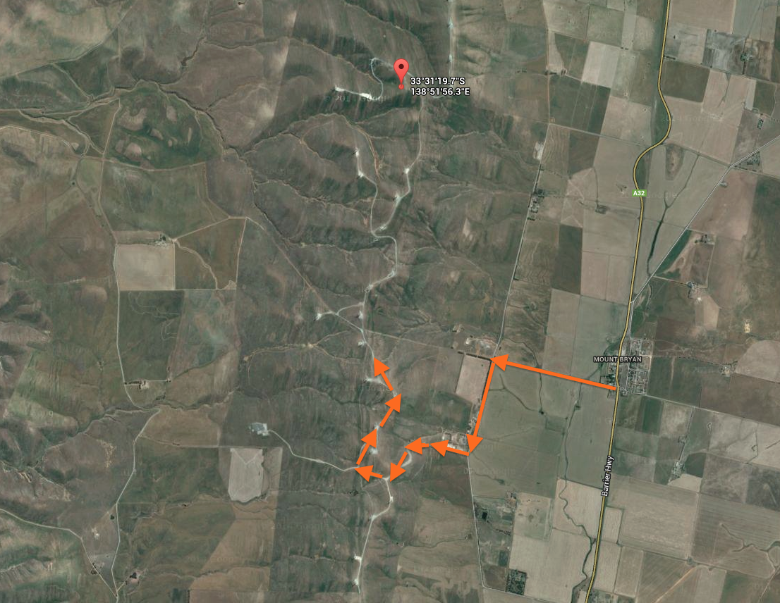
My one and only activation for Saturday 4th October, 2014, was Hallett Hill, VK5/ SE-003, which is located about 180 km north of Adelaide, and about 2 km north west of the little township of Mount Bryan, in the Mid North of South Australia.
Map courtesy of mapcarta.com
I got up early and after a hearty breakfast at the Commerical Hotel at Jamestown, I headed towards New Campbell Hill, VK5/ SE-007, which is situated on the edge of the Bundaleer Forest Reserve. However, much to my disappointment, there was a sign on the gate at Neindorf Road, stating that access was prohibited due to reforest operations. Bugger ! So I looked at possible alternatives and was lucky enough to make contact with the land owner of Hallett Hill. So south east I headed towards Mount Bryan.
Hallett Hill is an easy summit to access. It is located on private property, so please obtain permission from the land owner prior to entry. Details can be found on the SOTA site. I had activated this summit with Ian VK5CZ in July 2013, but it appears we entered the summit from the northern end via another land owner’s property. This time I travelled out along the Mokota Road, at the southern end of the Mount Bryan township. Upon reaching the T junction, turn left onto Collinsville Road. A few km up on your right you will reach a set of double gates with various signs on them including ‘High Voltage. Authorised personnel only. Keep out‘. This is where you access the summit. The dirt road will take you to the ridge line, where you need to travel north to the actual summit.
map courtesy of googlemaps.com
map courtesy of googlemaps.com
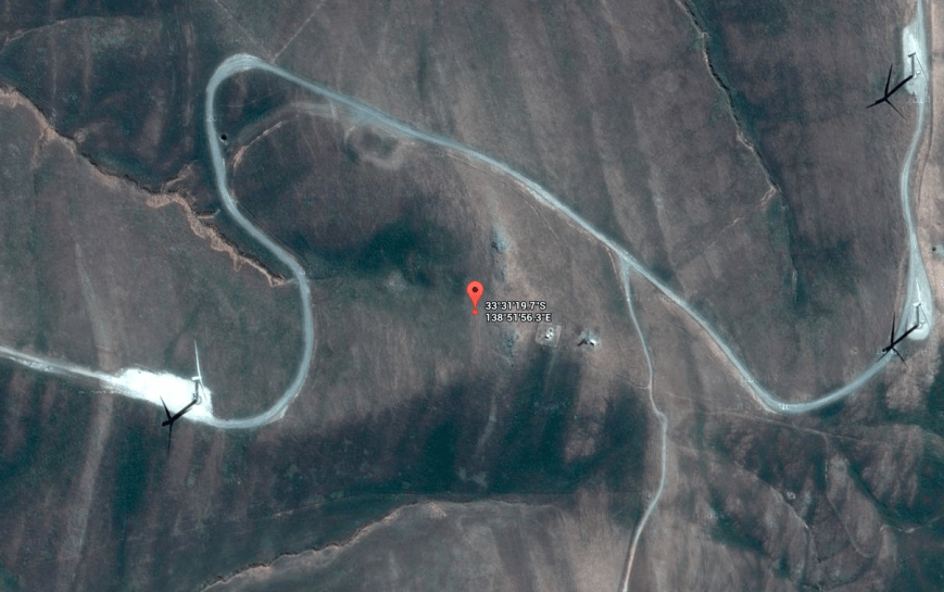
I used a wire fence and post to secure the 7 m squid pole, with some octopus straps. As this was the 2nd year anniversary of the Summits on the Air (SOTA) program) in South Australia, I had the SOTA flag flying proudly. And it was certainly flying! As expected, the wind was very strong on the top of the hill. After all, I was set up amongst a wind farm. Again, for this activation I ran the Yaesu FT-817nd and 5 watts and the linked dipole.
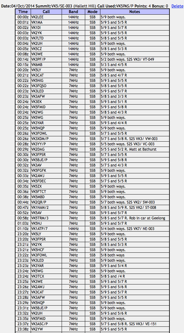
I propped on 7.090 on 40 m and called CQ and this was responded to immediately by Larry VK5LY with a very strong 5/9 plus signal from The Riverland. This was followed by SOTA stalwart, Peter VK3FPSR, Adam VK2YK, and then the ever reliable Col VK5HCF at Mount Gambier. A steady flow of callers from VK2, VK3, and VK5 followed. The band appeared to be very good, with excellent signals coming in from both locally and the eastern states. And I was receiving good signals back from as far afield as New South Wales, with my 5 watts.
Sadly, there was a large amount of noise on 40m, most likely generated by the wind turbines. It was about a strength 3 at times, and was a really annoying squealing sound. So any low signals were quite difficult to copy, if not impossible.
I managed two summit to summit contacts on 40m prior to the UTC rollover. That was with Mark VK3ASC who was portable on Mount Elliot, VK3/ VE-151. Mark had a good 5/7 signal, and he reciprocated with a 5/8 signal report for me. A few contacts later, I was called by Peter VK3PF who was portable on Mount Hooghly, VK3/ VT-049. Peter was very low down (5/2), but fortunately at the time he called, the noise being generated by the wind turbines was low and we were able to make the contact.
After working a total of 26 stations on 40m SSB, I QSYd to 14.310 on 20m SSB and started calling CQ. My first contact on 20m was with Mike VK6MB, who was a little weak (5/3). I received a 4/3 signal report from Mike in Perth. Not bad really, considering the distance is nearly 2,600 km. This was followed by Ian VK1DI, VK7LTD, Matt VK1MA, Ian VK5CZ and Lee VK2LEE. All had good strong signals. I remained on 20m for the UTC rollover and worked a further 10 stations. This included a summit to summit contact with Peter VK3PF on Mount Hooghly, VK3/ VT-049.
I then moved back to 40m to give the SOTA chasers on 40m a chance to pick up another 4 points. First taker there again was Larry VK5LY, followed by Tony VK3CAT and then Nigel VK5NIG. I went on to work a total of 31 stations on 40m SSB after the UTC rollover.
This included a few summit to summit contacts. The first being with Mitch VK3XDM who was portable on Mount Rosea, VK3/ VW-003. Mitch’s signal was a good solid 5/7 and I received a 5/8 report from Mitch. Immediately following this, Glen VK3YY called in from Mount Ritchie, VK3/ VC-003 (5/5 both ways). I then spoke with Rob VK2QR who was portable on Mount Jackson, VK2/ SW-003. As always, Rob had a good signal (5/7 both ways). My final summit to summit contact on 40m SSB was with Andrew VK1NAM/2 who was portable on Baldy Range, VK2/ ST-008. Andrew as an excellent 5/8 signal and I received a 5/9 signal report from Andrew.
I had been patiently waiting for Paul VK1ATP/7 who was on SOTA peak, VK7/ NE-003, to come up on 20m. I had heard him talking with Andrew VK1NAM on 40m, but sadly, due to the wind turbine noise, he was just too weak to work. Just before I was about to pack up, the SOTA Goat app bleated on my i-phone, and it was a spot for Paul on 14.310. I had already lowered the squid pole, and removed the crocodile clips in anticipation. Paul was a beautiful 5/4 signal coming in, and I was fortunate enough to make my first ever VK7 SOTA contact. And a summit to summit to boot. I was very happy.
This slideshow requires JavaScript.
After about 90 minutes on the hill, it was time to pack up and head off. I had a total of 73 contacts on 40m SSB and 20m SSB in the log.