Tonight I emailed out a participation certificate to all of the activators who took part in the 2017 VKFF Activation Weekend. The photo features a track in the Colquhoun Regional Park (taken by VK5PAS).
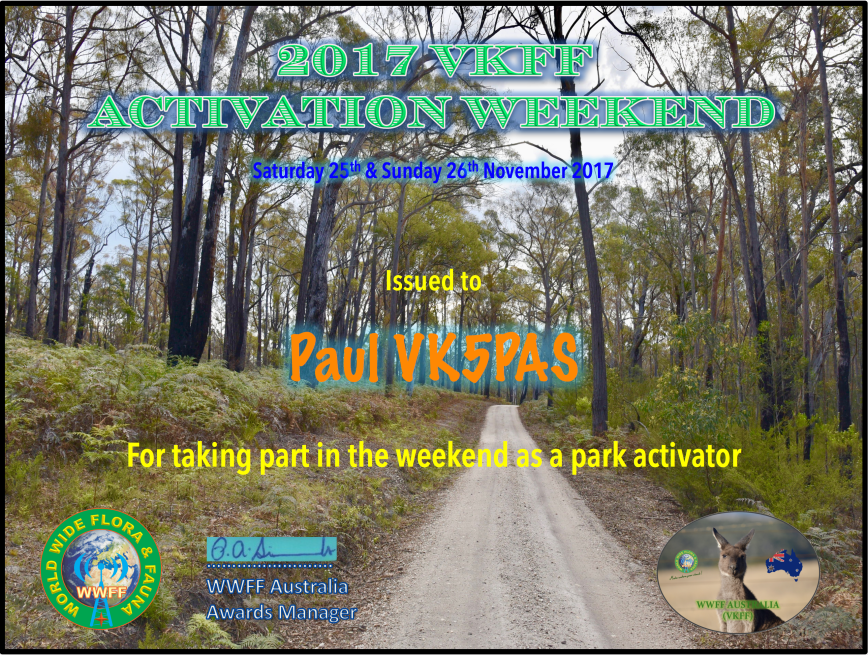

Tonight I emailed out a participation certificate to all of the activators who took part in the 2017 VKFF Activation Weekend. The photo features a track in the Colquhoun Regional Park (taken by VK5PAS).
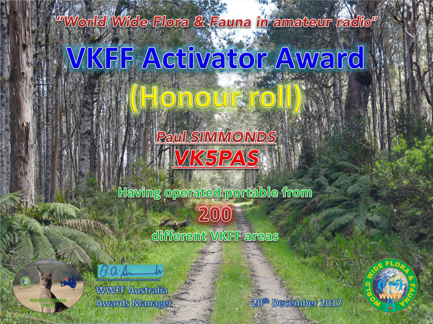
Tonight I received my latest certificate for the World Wide Flora Fauna (WWFF) program. It is the VKFF Activator Honour Roll 200 certificate, which is issued for having activated a total of 200 or more VKFF reference areas.
I would like to thank all of the hunters who have called me during my activations in VK1, VK2, VK3, VK5, VK6 and VK9. I’ve had a lot of fun along the way and have seen some great spots around Australia.
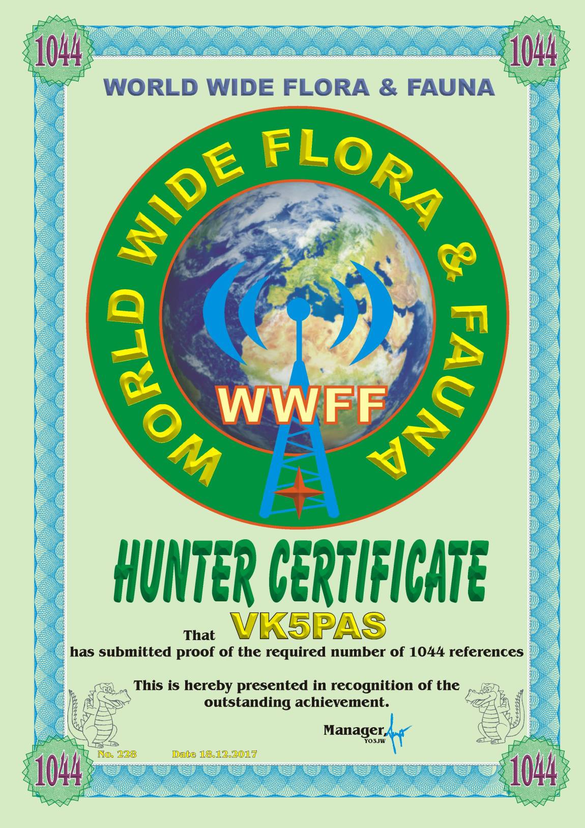
Today I applied for and received my WWFF Hunter 1044 certificate.
It is issued for having worked 1,044 different WWFF reference areas.
Many thanks to all of the activators around the world and thankyou to Pit YO3JW, the WWFF Awards Manager.
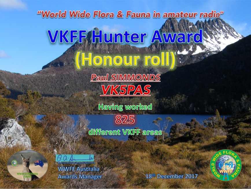
This morning I qualified for my latest certificate in the World Wide Flora Fauna (WWFF) program, the VKFF Hunter Honour Roll 825 certificate.
It is issued for having worked 825 different VKFF references.
Thankyou to all of the VKFF activators.
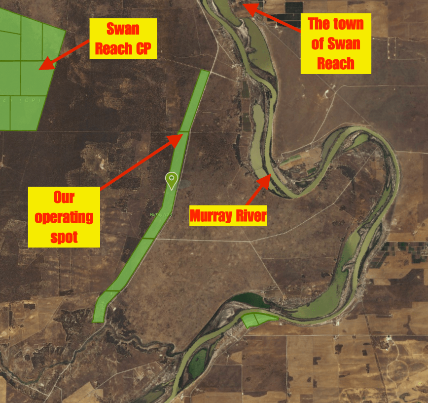
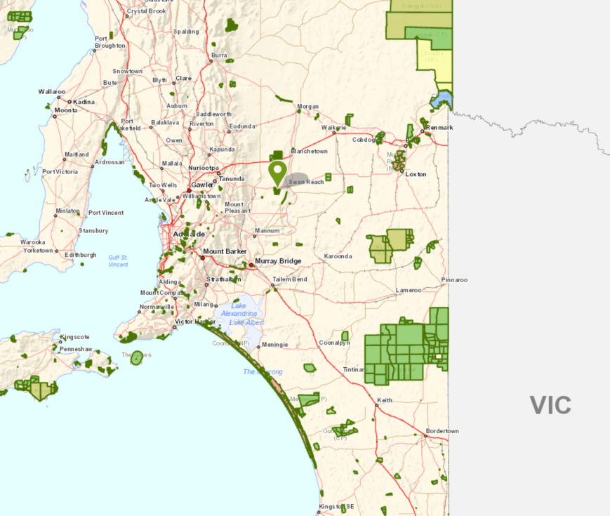
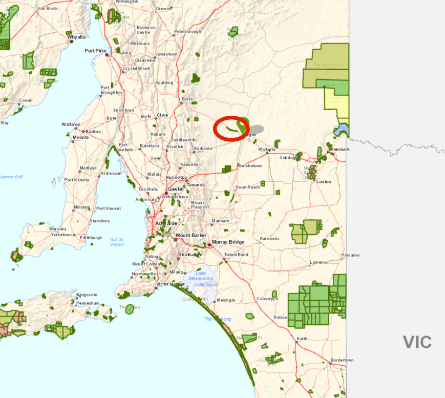
Our final activation for the 2017 VKFF Activation Weekend was the Ridley Conservation Park VKFF-0932, which is situated about 111 km north east of the city of Adelaide and about 26 km south west of the town of Swan Reach.
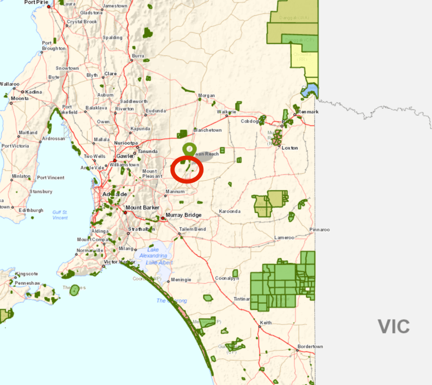
Above:- Map showing the location of the Ridley Conservation Park north east of Adelaide. Map courtesy of Location SA Map Viewer.
After leaving the Swan Reach Conservation we headed back east on the Stott Highway and then turned right onto Murraylands Road passing through the little locality of Langs Landing. There are some nice spots to stop here to enjoy the great views of the Murray River.


We soon reached the northern section of the park. Whilst travelling along the Murraylands Road we logged Les VK5KLV/p from the mobile. Les was in the Whyalla Conservation Park VKFF-0808 on the Eyre Peninsula. We turned down a dirt track at the intersection of Murraylands Road and Railway Sleeper Track. Don’t try this if you are in a conventional vehicle. The track is very narrow and is rocky.


The Ridley Conservation Park is a long and narrow park (10km by 0.4 km) and has a total area of around 414 hectares. The southern boundary of the park lies on the edge of the valley of the River Marne, with the highest point in the park being located in this southern section. The remainder of the park to the north comprises flat country which is typical of the limestone plaines west of the Murray River. The park covers a transition zone in the natural vegetation just to the south of Goyder’s Line between the mallee open scrub to the south and the semi-arid, low woodland to the north.
The park is covered by two major vegetation formations: 35 per cent comprises an open scrub of red mallee and stands of murray pine and associated areas of shrubland dominated by hop bush. The remaining 65 per cent of the park comprises low open woodland of native apricot and false sandalwood. The understorey consists of spear-grass and ephemeral herbs; wait-a-while also occurs in this formation. A small area near the southern boundary of the park and much of the northern part is almost devoid of trees and can be sub-categorised as open grassland.


The park was originally set aside to conserve native vegetation and bird habitats, but in addition, the open areas of the park include a number of warrens of the Southern Hairy-nosed Wombat. Other native animals found in the park include echidna and Western Grey kangaroos. Various birdlife can be found in the park including Mallee Ringnecks, Purple-crowned Lorikeets, Regent Parrot, White-winged Fairywren, and Butcherbirds. A total of 109 species of bird have been recorded in the park.
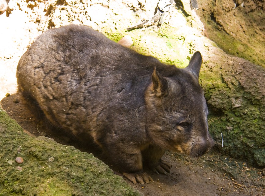
Above:- the Southern Hairy-nosed Wombat. Image courtesy of wikipedia.
Ridley was once part of a Travelling Stock Reserve (TSR) which ran for roughly 5-10 kilometres parallel to the River Murray. This reserve linked the stock market of Burra to the north with Murray Bridge to the south. In the early days of the colony of South Australia, sheep and cattle were driven overland from New South Wales to stock the newly-developed pastoral industry in South Australia. During the early 1860’s when the Hundreds of land were proclaimed on the western plains of the Murray River, it became necessary to provide areas under the Crown for the localised movement of stock and to give access to markets. Travelling Stock Reserves, which normally consisted of 20-chain (approx 400 metres) width, were given fixed boundaries and often followed existing stock tracks.

This particular stock route, as with others, became uncessary with the advent of mechanised transport such as the railway. The Morgan to Adelaide railway was completed in 1878. Increasingly there were moves to resume and allot the TSRs to adjoining landowners.
By 1901 local landowners in the Ridley area had approached the Department of Lands, requesting that the TSR in the Hundreds of Ridley and Fisher be resumed and made open for allotment. During 1901 and again in 1907, proposals went before Parliament, but were not approved. In 1910 farmers adjoining the reserve requested permission to erect fences and graze sheep on the TSR, claiming that the unused TSR harboured vermin and tied up valuable grazing land.
By 1934 the District Council of Caurnamont had contacted the Director of Lands requesting that the TSR be resumed for allotment, again claiming that it was a home for vermin and was a drain on council funds. Similar requests were made again in 1937. In 1939, the ranger of the Crown Lands Department, Inspector Klau inspected the TSR and reported that it was used for camping and watering stock when feed was scarce in the districts to the north of the TSR. He recommended that the TSR not be resumed as he believed the reserve would be used for this purpose again in the future.
During 1838-1940 there were a number of requests to cut wood in the reserve for charcoal burning and a proposal to clear 28 hectares of the reserve north of Haywards Hill. The ranger described the reserve as ‘an asset to the State’ and recommended the TSR be retained in its uncleared state.
By 1956 there were further requests to utilise the TSR and on this occsion Annual Licences were granted for grazing purposes.
In 1966 when land was being resumed and purchased for the purpose of national parks, the Land Board proposed that portions of the TSR “be retained and dedicated as a Wildlife Reserve under the control of the Commissioners of the National Parks and Wildlife Reserves at the expiration of the current Annual Licence”. In September 1967, a field officer for the National Parks Commission, Mr. G.C. Cornwall inspected the TSR and stated “Although a long narrow strip of land such as this is not the ideal shape for a national park, the idea of preserving natural vegetation and bird habitats by setting aside portions of the Travelling Stock Reserve is an excellent one and the area under investigation is suitable for this purpose‘.
First proclaimed as Ridley National Parks Reserve on 30 May 1968 and re-proclaimed on 27 April 1972 as Ridley Conservation Park.
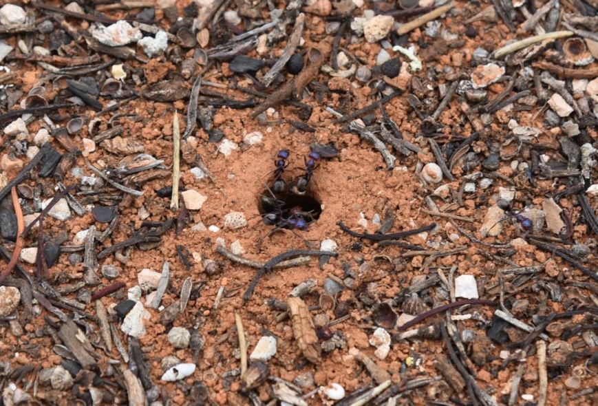
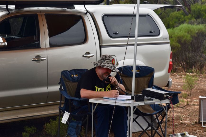
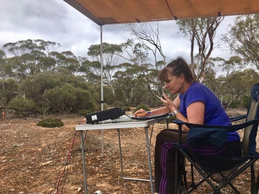
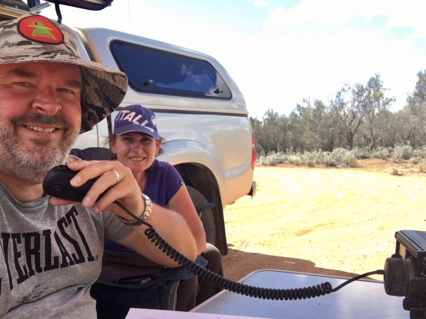
Unfortunately I didn’t look down when setting up the awning/annexe on the Toyota Hi Lux. We had set up just 3 metres away from a number of ants nests. Fortunately they kept their distance and didn’t cause us any dramas during the activation.
After setting up we immediately went to 7.150 and logged Les VK5KLV/p, Park to Park, from the Whyalla Conservation Park VKFF-0808 in the ‘Iron Triangle’ region of South Australia. Marija then headed down to 7.130 and called CQ, which was answered by Mick VK3GGG/VK3PMG, followed by Neil VK4HNS/p in the Girraween National Park VKFF-0198.
The static crashes were terrible, strength 9 plus at times and it made operating very difficult. Under some very trying conditions, Marija logged a total of 24 stations before deciding that the static crashes were just too annoying. Included in these contacts were a number of further Park to Park contacts as follows…..


I then put out some calls on 7.130 and despite the very severe static crashes, was able to log 19 stations from VK1, VK3, VK3, VK4, and VK7. Marija and I then lowered the squid pole and inserted the 80m links and headed to 3.610. I logged 5 stations on 80m, the first being Mick VK3GGG/VK3PMG, followed by John VK5BJE, Adrian VK5FANA, and finally Adrian VK5FANA.
Whilst on 80m Marija received a call from Greg VK8GM, who was part of the VK8ZKZ team in a park in the Northern Territory. He advised that they were on 15m, so Marija and I quickly put up the 15m 1/2 wave, but sadly could not hear a peep from Greg and his team. I called CQ on 21.244 and logged Tadashi JA1VRY in Japan.
Greg phoned back to ask if we could try 20m. So it was off to 20m, but again we could not hear Greg. We could hear the VK2 and VK6 hunters. Also at this time we saw Allen VK3ARH/p spotted on parksnpeaks on 40m in a park. So rather than taking down the 15m dipole, we worked Allen from the vehicle. He was a good 5/7 from the Mount Mercer Nature Conservation Reserve VKFF-2154.
Down came the linked dipole again, and back with the 15m dipole. I logged just one more station on 15m, that being Nigel VK6NI, who although quite weak, was very workable from Ridley. I then re-erected the 20/40/80m linked dipole and headed to 14.310, where I found Phil VK6ADF/p in the Coalseam Conservation Park VKFF-1418. I logged Phil, Park to Park, and then headed up the band to 14.315 where I logged 6 stations from VK4, VK6, VK7 and Japan.
To wrap up the activation I went back to 7.144 on 40m where I logged 13 stations from VK1, VK2, VK3, VK4, VK6, and VK7, including a Park to Park with Nik VK3NLK/p who was in the Langwarrin Flora & Fauna Reserve VKFF-2031.
It was time to call it a day and head home after a very enjoyable 2017 VKFF Activation Weekend. From Ridley, Marija had 25 contacts in the log, including 9 Park to Park contacts, whilst I had 54 QSOs in the log, including
Marija worked the following stations on 40m SSB:-
I worked the following stations on 40m SSB:-
I worked the following stations on 80m SSB:-
I worked the following stations on 15m SSB:-
I worked the following stations on 20m SSB:-
After packing up Marija and I headed to Shell Hill, just off the Black Hill Road. Shell Hill is so named due to the deposit of oyster shells which is believed to be about 5 million years old. It is the only one of its kind above the surface of the earth in the Southern hemisphere. It is quite a sight.


We continued along the Black Hill Road until we reached the little town of Black Hill which is located on the banks of the Marne River. Until 1918, when many places in South Australia had their names changed due to anti German sentiment in World War One, the town was known as Friedensthal, meaning ‘Valley of Peace’. In its day there was quite a community here, including a post office, school and shop. But today all that remains are some farmhouses, the old church, and the hall.


We continued on to the Ridley Road and eventually home. It was a relatively slow drive as there were many kangaroos out on the road.


References.
Birds SA, 2016, <http://www.birdssa.asn.au/location/ridley-conservation-park/>, viewed
Discover Murray, 2017, <http://www.murrayriver.com.au/swan-reach/shell-hill/>, viewed 4th December 2017
National Parks and WIldlife Service, 1984, ‘Conservation Parks of the Murraylands (Western Plains) Management Plans
Wikipedia, 2017, <https://en.wikipedia.org/wiki/Black_Hill,_South_Australia>, viewed 4th December 2017
Day two (Sunday 26th November 2017) of the 2017 VKFF Activation Weekend had arrived. Marija and I had enjoyed 2 great nights in Morgan and it was time for us to move on to our first park activation of Sunday, the Swan Reach Conservation Park VKFF-0832 which is located about 170 km north east of Adelaide and about 12 km west of the town of Swan Reach.
Above:- Map showing the location of the Swan Reach Conservation Park. Map courtesy of Location SA Map Viewer.
After breakfast we headed down to the ferry at Morgan, which crossed the Murray River. There are a couple of ways of getting to Swan Reach from Morgan, but this is the way the GPS decided to take us. On the way to the ferry I spoke from the mobile with Liz VK2XSE/p on 7.144. Liz was activating the Balowra State Conservation Area VKFF-1269 in New South Wales.
Whilst waiting for the ferry, and then whilst on borad the ferry crossing the river, Marija and I worked Mick VK3PMG/p on 7.160, who was in the Jallukar Nature Conservation Reserve VKFF-2115. Mick had a good 5/7 signal into the mobile, and gave us a 5/7 in return.


We travelled south on the Murbko Road which runs alongside the mighty Murray River. There are a number of spots here where you can stop to enjoy some spectacular views of the Murray River, which is exactly what we did.


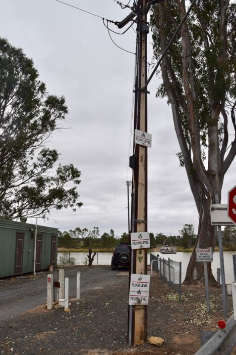
We then reached the Sturt Highway and headed towards the town of Blanchetown, before turning left on to Hunter Road which again hugged the Murray River to our right. The town of Swan Reach was our next stop. Swan Reach was initially settled way back in the 1850’s and was originally the largest of five sheep and cattle stations in the area. It subsequently became a busy riverboat port in South Australia. We waited to board the ferry at Swan Reach, whilst having a look at the flood levels on an electricity pole. The 1956 flood literally wiped out the town of Swan Reach.
After crossing the Murray, we travelled west on the Swan Reach-Angaston Road (the Stott Highway), and soon reached the park. The Swan Reach Conservation Park is 2,017 hectares in size, with the majority of the park being an open area of Mallee Box, red mallee, and yorrell. The remaining area consists of low woodland with false sandalwood and bullock bush over an understorey of spear-grass and ephemeral herbs.
About 97 species of native bird have been recorded in the park including Chestnut-rumped Thornbill, Southern Whiteface, Spiny-cheeked Honeyeater, Grey Shrikethrush, Australian Magpie, Malleefowl, Little Eagle, Crested Pigeon, and Inland Thornbill. Most of the mallee scrub in the park has been cut ver for firewood and the present vegetation is regowth. The park lacks the numbers of large, mature mallees which originally occurred in the area and provided nesting hollows for birds. I hardly saw a bird in the park during our visit.
Native animals found in the park include Western Grey kangaroos, Red Kangaroos, and the Southern Hairy-nosed wombat. Gould’s Goanna and Central Beared Dragons can be found in the park.
Marija and I turned on to the Old Punyelroo Road and then on to a dirt track leading into the park.
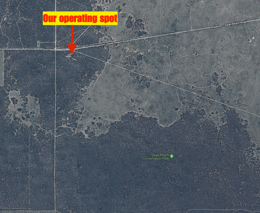
Above:- Aerial shot showing our operating spot in the park. Image courtesy of google maps
There was plenty of room here to pull the Toyota Hi Lux off the track and roll out the awning/annexe, and stretch out the 20/40/80m linked dipole.


As we drove in to the park we worked Marc VK3OHM/p who was activating the Warrandyte State Park VKFF-0774. As we were within the boundaries of the park it qualified as a Park to Park contact, as mobile is allowed in the WWFF program. Marc had a cracking 5/9 signal into the mobile.
We set up and immediately headed to 7.140 to get another Park to Park with Marc VK3OHM/p as we were now set up portable. After logging Marc, we headed up to 7.150 and Marija started calling CQ, whilst I spotted her on parksnpeaks. Marija’s CQ call was answered by Tom VK5NFT at Millicent in the South East, followed by Tom VK5AA also in the South East at Mount Gambier, and then Chris VK3FHCT.
Our second Park to Park was to follow, a contact with Mick VK3GGG/VK3PMG who was activating the Jallukar Nature Conservation Reserve VKFF-2115. Marija soon had her 10th contact in the log, a QSO with John VK4/AC8WN. Marija then logged John under another one of his calls VK4/VE6XT and then our good friend John VK5BJE.
As it was a little quiet, we took the opportunity of tuning across the 40m band to see if we could find some more park activators. We soon found Gerard VK2IO/p who was activating the Pitt Town Nature Reserve VKFF-1984.
Marija then went back to 7.150 and called CQ, logging a total of 15 stations including the following three more Park to Park contacts….


Marija now had 28 contacts in the log and the calls on 40m had slowed down a little, so we decided to go have a listen on the 80m band. Marija called CQ on 3.610 which was answered by John VK5BJE, followed by Adrian VK5FANA, Tony VK5MRT, and then Ivan VK5HS mobile, all of whom had great signals on 80m. We also made a Park to Park contact with Mick VK3GGG/VK3PMG who was now activating the Illawarra Nature Conservation Reserve VKFF-2111. Mick had a good 5/5 signal.
We headed back to 40m where we logged the following Park to Park contacts…..
We returned to 7.150 and Marija continued to call CQ, logging a further 6 stations from VK2, VK3, VK4 and VK7. Unfortunately we had a couple of VK6 stations come up on the frequency, and despite us hearing them well, they were unable to hear either Marija or I. It just wasn’t worth competing with them, so we left the frequency. We found Mick VK3PMG/VK3GGG on 7.155 in the Illawarra Nature Conservation Reserve VKFF-2111. This was Marija’s 44th contact. She had qualified the park for the global WWFF program.
Marija then took a coffee break, whilst I put out a few CQ calls on 7.144 on 40m logging 16 stations from VK1, VK2, VK3, VK4, VK5, and VK7, including a Park to Park with Neil VK4HNS/p who was in the Girraween National Park VKFF-0198.
Marija and I then headed up to 21.244 on the 15m band, hoping to get a few contacts. And we were pleased that we put up the 15m /12 wave dipole as the band was wide open to New South Wales, Queensland and Western Australia. Our first contact on 15m was a Park to Park with Gerard VK2JNG/p who was in the Koreelah National Park VKFF-0268. Other Park to Park contacts on 15m were made with Neil VK4HNS/p in the Giraween National Park VKFF-0198, and Rob VK4AAC/p who was activating the Clear Mountain Conservation Park VKFF-1511.
So with a number of contacts in the log on 15m, it was time to try the 20m band. I logged 10 contacts there including the following Park to Park contacts…..
We were about to pack up when we noticed a spot for Les VK5KLV/p on 7.150 in the Whyalla Conservation Park VKFF-0808. So it was off to 40m again to log Les Park to Park.


Marija had 53 QSOs in the log including 18 Park to Park contacts. I had 49 QSOs in the log including 22 Park to Park contacts. Between us we had made 102 QSOs, including 40 Park to Park contacts.
Marija worked the following stations on 40m SSB:-
Marija worked the following stations on 80m SSB:-
Marija worked the following stations on 15m SSB:-
I worked the following stations on 40m SSB:-
I worked the following stations on 80m SSB:-
I worked the following stations on 15m SSB:-
I worked the following stations on 20m SSB:-
References.
Birds SA, 2017, <https://birdssa.asn.au/location/swan-reach-conservation-park/>, viewed 4th December 2017
Wikipedia, 2017, <https://en.wikipedia.org/wiki/Swan_Reach,_South_Australia>, viewed 4th Dceember 2017
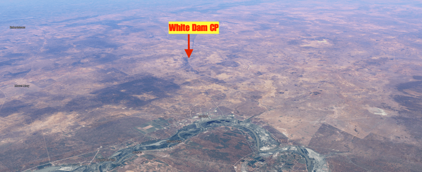
Our second activation for Saturday 25th November 2017 was the White Dam Conservation Park VKFF-1122, which is located about 200 km north east of Adelaide, and about 20 km north west of Morgan.
Above:- Map showing the location of the White Dam Conservation Park. Map courtesy of Location SA Map Viewer.
The White Dam Conservation Park is 891 hectares in size and is bisected by the Morgan-Burra Road, the Goyder Highway. The park was first gazetted on the 17th July 1969, and was originally part of a travelling stock route. On the 17th September 1970 it was proclaimed as White National Parks Reserve. On the 27th April 1972 it was gazetted as the White Dam Conservation Park.
This is pretty harsh and isolated country out here. The landscape is flat to gently undulating, with much of the park comprising low open woodland of Black Oak with an understorey dominated by Bluebush.


About 91 species of native bird have been recorded in the park including Galah, Black-backed Fairywren, Chestnut-rumped Thornbill, Southern Whiteface, Redthroat, Spiny-cheeked Honeyeater, Red-capped Robin, Stubble Quail, White-winged Fairywren, White-fronted Honeyeater, Apostlebird, White-browed Babbler, and Gilbert’s Whistler.
Above:- Aerial shot showing the location of the White Dam Conservation Park. Image courtesy of google maps
We turned off the Goyder Highway onto a dirt track which lead into the park, and set up at the intersection of a few tracks. There was plenty of room here to string out the 80/40/20m linked dipole.
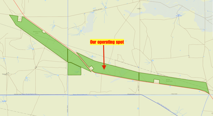
Above:- Map of the White Dam Conservation Park, showing our operating spot. Map courtesy of Location SA Map Viewer
Marija kicked off the activation, calling CQ on 7.150. John VK5BJE was the first in the log with a 59 plus signal, followed by Adrian VK5FANA who was also 5/9 plus, Brett VK2VW, and then Rick VK4RF/VK4HA. Contact number 7 was our first Park to Park contact at White Dam, a QSO with Mark VK4SMA/p who was activating the Moggill Conservation Park VKFF-1594 in Queensland. This was followed by a run of further Park to Park contacts as follows:
Marija now had 11 contacts in the log and had qualified the park for VKFF and handed the mic to me. I called CQ and this was answered by John VK5BJE, then Les VK5KLV, and then Hans VK5YX, all of whom had 5/9 signals into White Dam.


I went on to work 52 stations on 40m, swapping the mic with Marija whenever a Park to Park contact came up. And there were plenty of those, as follows…..
Marija then jumped back on the mic, with 30 contacts in the log, and hoping to get 14 more QSOs to qualify the park for the global WWFF program. Marija soon had 44 contacts in the log, with contact number 44 being a QSO with Andrew VK2UH. We also logged another Park to Park contact, this time with Peter VK3ZPF/p who was activating the Buckley Nature Conservation Reserve VKFF-2054.
I then went up to the 20m band and found Tony VK7LTD/p on 14.310 calling CQ from the Safety Cove State Reserve VKFF-1825. I then moved up to 14.315 where I logged 8 stations including Bob VK6POP/p who was activating the Walyunga National Park VKFF-0516 and Hans VK6XN/p in the Buller Nature Reserve VKFF-1868. I also found Martin VK6AHR/p on 14.310 calling CQ from the Avon Valley National Park VKFF-0008.
I then put out a few calls on 3.610 on the 80m band, but the only station/s logged there was Mick VK3GGG/VK3PMG. To finish off the activation I called CQ on 21.244 for a few minutes, but there were no takers.
We then packed up and left the park, with Marija having 47 contacts in the log including 23 Park to Park QSOs. I had 69 contacts in the log, including 28 Park to Park QSOs. Between us, we had 116 QSOs, including 51 Park to Park contacts.
Marija worked the following stations on 40m SSB:-
I worked the following stations on 40m SSB:-
I worked the following stations on 20m SSB:-
I worked the following stations on 80m SSB:-
After packing up we headed to the historic Lindley cemetery which is located, funnily enough, on Lindley Cemetery Road. As we travelled on this road it gave you a great feel on how vast and isolated this land is.


The Lindley cemetery has many headstones dating back to the 1800’s. There are also the ruins of the old school and church to be found here. Both date back to the late 1800’s. Sadly all that remains is a pile of stone.

")


We also had a look at the Henry Bryan memorial. I spoke about this very interesting story in the last post.


That night we tried the second pub in town, the Terminus, and enjoyed a very nice meal.
References.
Birds SA, 2017, <https://birdssa.asn.au/location/white-dam-conservation-park/>, viewed 3rd December 2017
Our first activation for the 2017 VKFF Activation Weekend was on Saturday morning (25th November 2017) and was the Morgan Conservation Park VKFF-0911. Marija and I have both activated and qualified this park previously, but it is such a lovely spot, that we chose to come back here for the weekend.
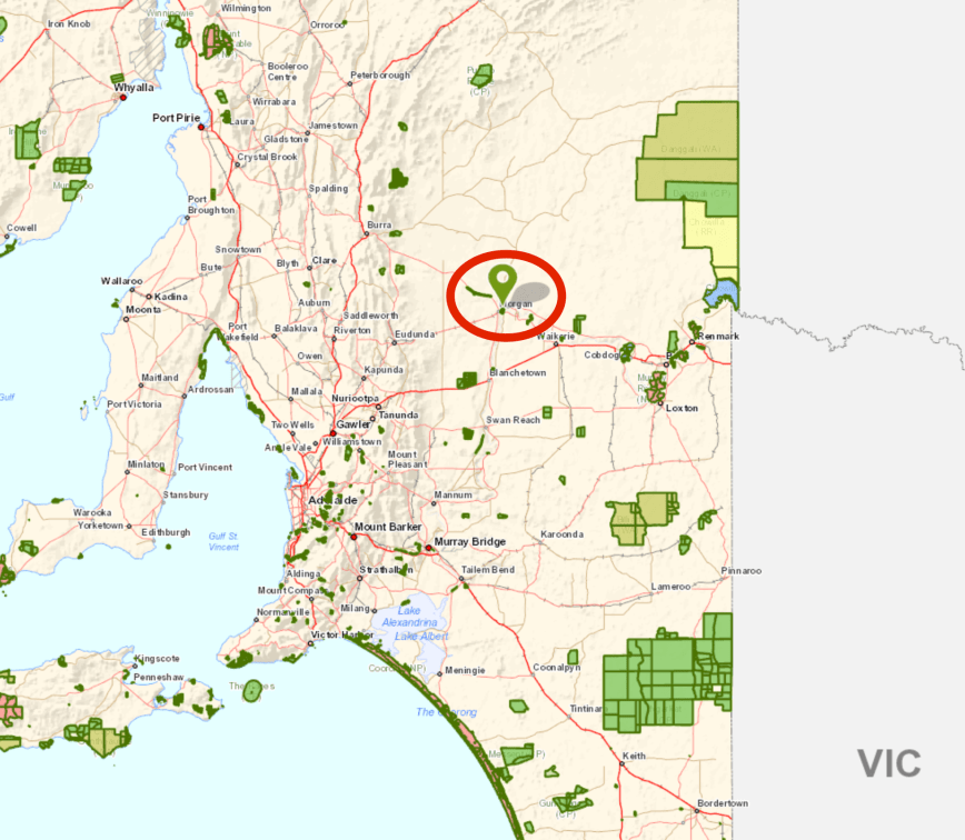
Above:- Map showing the location of the Morgan Conservation Park. Map courtesy of Location SA Map Viewer.
After breakfast we headed down to the Morgan ferry. To get to the park we needed to cross the Murray River. It was another beautiful warm and sunny morning.


Just after getting off the ferry on the Morgan-Cadell Road, we soon reached the park boundary which incorporates the Morgan Lagoon, located either side of the road.


The Morgan Conservation Park is about 376 hectares in size and was first gazetted on the 23rd September 1976 to protect the wetlands with a size of 361 hectares. On the 4th November 1993 the park was expanded with the addition of 11 more hectares. The park contains River Red Gum, Red Mallee, Erect Mallee Bluebush, Lignum Open Scrub and Tussock Grassland.
About 147 species of native birds have been recorded in the park including Grey Teal, White-faced Heron, Whistling Kite, Australasian Darter, Whistling Kite, Sulphur-crested Cockatoo, Yellow Rosella, Noisy Miner, Tree Martin, Blue-billed Duck, Black-shouldered Kite, Australasian Bittern, Whiskered Tern, Striped Honeyeater, Apostlebird, and Zebra Finch.


We turned down a dirt track on the southern side of the Morgan-Cadell Road. The track was obviously dry during our visit and was in good condition. But it is quite sandy and I would not recommend trying your luck when it is wet in a conventional vehicle.
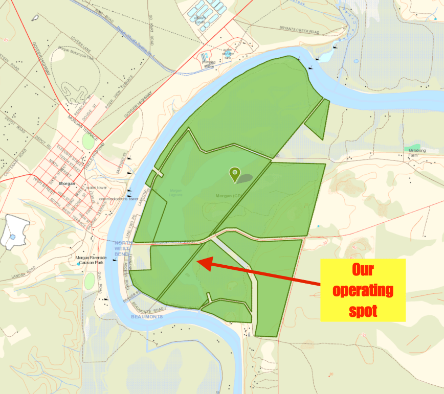
Above:- Map showing the Morgan Conservation Park, and our operating spot. Map courtesy of Location SA Map Viewer.
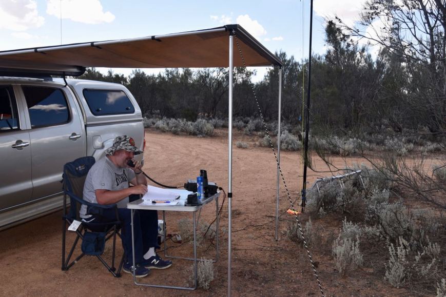
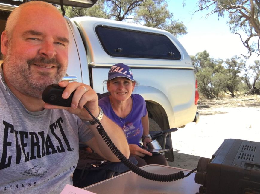
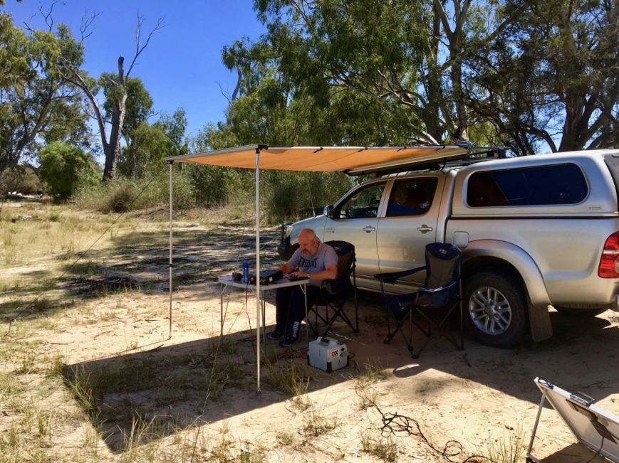
We followed the track for a short distance and set up alongside of the southern lagoon, only a few metres away from the waters edge. As it was a warm morning we erected the awning/annexe of the Toyota Hi Lux, and sat underneath its shade in the deck chairs and the fold up table.


Prior to propping on a frequency and calling CQ, Marija and I had a quick tune across the 40m band to see if there were any other park activators out and about. It was still qite early, about 9.45 a.m. South Australia local time. We found Gerard VK2JNG/p on 7.150, who was activating the Moore Park Nature Reserve VKFF-1967 in New South Wales.
After logging Gerard we moved down to 7.144 and I started calling CQ. This was answered by Les VK3FLES, followed by Peter VK3PF/p who was activating SOTA summit VK3/ VT-047 which was in the Avon Wilderness Park VKFF-0942. There was a lot of bird activity in the park and I was keen to get some photos, so I handed back the mic to Marija who logged Keith VK2PKT and then Angela VK7FAMP/p and her husband Tony VK7LTD/p in the Eaglehawk Bay State Reserve VKFF-1797. Whilst taking some photos I ran back quickly to log Angela and Tony as well, Park to Park. Another couple of Park to Parks followed. This time it was husband and wife team Jonathan VK7JON/p and Helen VK7FOLK/p who were in the Table Cape State Reserve VKFF-1829 in Tasmania.


Marija and I continued to swap the mic, whilst I took photographs. The band was in good shape and was alive with callers which was great to see. We worked stations from VK2, VK3, VK4, VK5, and VK7. We made the following further Park to Park contacts before the UTC rollover at 10.30 a.m. South Australian time ….
After the UTC rollover the constant flow of callers continued. We made the following Park to Park contacts on 40m after the UTC rollover…..
When things slowed down a little we had a tune across the band and worked Ade VK4SOE/p who was activating the Girraween National Park VKFF-0198 in Queensland.
We then lowered the squid pole and inserted the 80m links and headed to 3.610 where we I worked Adrian VK5FANA on the Yorke Peninsula, John VK5BJE in the Adelaide Hills, and Tony VK5MRT in Strathalbyn. We alsomade some Park to Park contacts with Mick VK3GGG/VK3PMG in the Mount Bolangum Nature Conservation Reserve VKFF-2147. Mick was quite low down to us (3/3), but we made it in the end (thanks to Mick’s patience) exchanging signal reports.
We headed back to 40m and worked Tony VK3XV/p who was activating the Heathcote-Graytown National Park VKFF-0624. We then propped on 7.144 and called CQ again, where we logged a number of stations including a further 6 Park to Park contacts…..
I then put out a CQ call on 14.310 on the 20m band. I logged a total of 19 stations there, with my first contact being Hans VK6XN, followed by Phil VK6ADF. I always enjoy logging the Western Australian stations because it is a long haul to get across there. I worked the following Park to Park contacts on 20m…..
We then headed back to 40m and tuned across the band and logged some more Park to Park contacts as follows…..
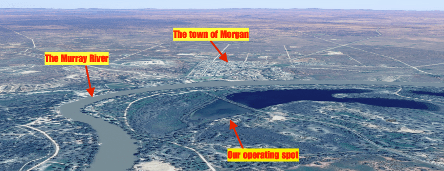
Above:- Aerial shot of the park showing our operating spot, the town of Morgan, and the Murray River. Courtesy of google maps
To complete the activation at Morgan, Marija and I decided to try the 15m band. We were hoping to work some of the Western Australian stations and perhaps some Queensland Foundation operators. And we were not to be disappointed, with working both. We also made the following Park to Park contacts on 15m…..
It was a great way to wrap up the activation. Marija had 55 contacts on the log, including 33 Park to Park QSOs. I had 92 contacts in the log, including 38 Park to Park QSOs. So between us, we had 147 QSOs, including 71 Park to Park contacts.
Whilst in the park I did quite a bit of bird watching (of the feathered kind), and took the photos below…..
Marija worked the following stations on 40m SSB before the UTC rollover:-
Marija worked the following stations on 40m SSB after the UTC rollover:-
Marija worked the following stations on 80m SSB:-
Marija worked the following stations on 15m SSB:-
I worked the following stations on 40m SSB before the UTC rollover:-
I worked the following stations on 40m SSB after the UTC rollover:-
I worked the following stations on 80m SSB:-
I worked the following stations on 20m SSB:-
I worked the following stations on 15m SSB:-
References.
Birds SA, 2017, <https://birdssa.asn.au/location/morgan-conservation-park/>, viewed 3rd December 2017
After packing up at the Brookfield Conservation Park, Marija and I drove a little further east until we reached the small town of Blanchetown, located on the mighty Murray River. Blanchetown is about 130 km north east of Adelaide and was once an important riverbank terminal where goods were loaded and offloaded from the various paddlesteamers which travelled the length of the river. The town was surveyed back in 1855 and was one of the first river settlements in the Colony of South Australia. It was named by Governor Sir Richard Graves McDonnell after his wife, Lady Blanche McDonnell.
Blanchetown is home to Lock and Weir 1, which was completed in 1922, and was the first on the Murray River system. It was originally consturcted to provide year-round river navigation for commercial cargo boats and for irrigation diversions by pumping or gravity. On the downward side of the lock, there were dozens of pelicans, all waiting for fish to spill over the lock.


We then drove out of Blanchetown on the Murraylands Road, which is partially bituminised and partially dirt (in good condition). We passed the little settlement of Roonka, which is where the Roonka Conservation Park is located. This park has never been activated previously and from what I have read access may not be allowed due to aboriginal skeletons having been found at Roonka. I will have to do a bit of research and see whether I may be able to activate this park in the near future.
We soon reached the town of Morgan which is situated about 165 km north east of Adelaide. It is located on what is referred to as the ‘Great Bend’, the ‘Great Elbow’, or the ‘North-west bend’, where the Murray makes a significant 90 degree turn.
Morgan was once one of the busiest river ports in South Australia. The town was proclaimed in 1878 and was named at that time after Sir William Morgan, then Chief Secretary, and later Premier of South Australia. At its peak, Morgan was the second busiest port in South Australia (behind only Port Adelaide), with six trains a day carrying freight from the Murray to the sea at Port Adelaide. Over the years as road transport improved, the river transport declined. In 1969, the the railway to Morgan finally closed.
Marija and I made a visit to the Tourist Information Centre and then took a short walk to the wharf to have a look at the railway museum, which unfortunately was closed.


We then sat on the banks of the Murray and had some lunch. The waterfront was alive with Corellas, most of which were taking shade in the gum trees. It was a very warm day.


There is a lot to see in Morgan, particularly if you are a history buff. Marija and I took some time out to have a look at some of the sights and then headed to the Morgan Museum.


The Morgan Museum is located in the historic Landseer building in Railway Terrace. It is well worth a visit and contains a great collection of historical items. The building itself dates back to 1878 and was built by the shipping firm A.H. Landseer and acted as a Merchants, Commission and Shipping Agents building.
We then booked in to our motel, the Morgan Colonial Motel, which we can highly recommend.
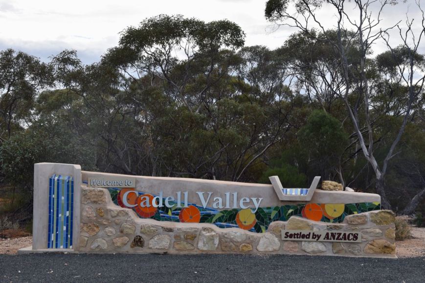
It was now early afternoon and Marija and I decided to head to the Caudo Vineyard at Cadell. We headed out of Morgan on the Goyder Highway, named after the South Australian Government Surveyor George Goyder, and then took the ferry across the Murray River to Cadell.
Cadell was surveyed in 1919, and was named in 1920 after Captain Francis Cadell, a pioneer of steam powered navigation on the Murray River.
We soon reached the Caudo Vineyard which is surrounded by beautiful lawned grounds.
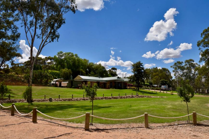
The winery is situated on the banks of the Murray River, and during our visit a houseboat had moored at the winery, with the occupants enjoying some of the wines at Caudo. The winery is located on what was known as Watchow’s Landing, named after Herman and Emma Watchow, early pioneers of the area.


We sat in one of the booths and enjoyed a cheese platter and a few beverages. You can endulge in some of Caudo’s Shiraz, Temranillo, or Rose. But one of Caudo’s specialties is Sangria. Sangria is of Spannish and Portuguese origin and is a punch, traditionally consisting of red wine and chopped fruit, often with other ingredients such as orange juice or brandy. As it was a warm afternoon, it was an ideal day to enjoy a few Sangrias. We highly recommend a visit to Caudo Vineyard if you are in the Cadell area.


We then decided to take the short drive down the end of Hogwash Road, to activate the Hogwash Bend Conservation Park VKFF-0892. Although both Marija and I had activated the park previously, we decided that a quick activation was a good idea as we still had a bit of time up our sleeve before dinner.
The park was gazetted in 2012 and is about 286 hectares in size.


The park was acquired by the South Australian State Government and the Australian Federal Government under the National Reserve System program to protect the largest breeding colony of Regent Parrots in South Australia. There are thought to be only 300 breeding pairs of Regent parrots along the Murray. And in Hogwash Bend, around 50 pairs use the ideal breeding habitat of mature river red gums, nesting sites and large areas of mature mallee scrubland. Hogwash Bend plays an important role in the bird’s future which is listed as vulnerable at both State and National level.
There is an excellent website dedicated to Regent parrots which can be found at…..
If you travel to this park, please ensure that you are within the boundaries. You will find a park sign on the right hand side as you travel down Hogwash Road towards the river. But the sandy camping area is not part of the park. You need to go to the scrub to the east of the camping area.


The 40m band was very noisy, with loud static crashes, but despite that the band was full of activity. I couldn’t get on to 7.144, so I started calling CQ on 7.138, whilst Marija spotted me on parksnpeaks. My first caller was Keith VK2PKT in Parkes with a strong 5/9 signal. This was followed by Rob VK2QR, Mick VK3GGG/VK3PMG, and then Andrew VK7DW. Contact number 10 was with Rob VK7VZ/2 who politely asked if I could shift frequency as he was about to have a sked into Europe. So after a bit of a chat with Rob I headed to 7.150.
I logged a further 14 stations on 40m, from VK2, VK3, VK4, VK5 and VK7 before heading to 3.610 on the 80m band. There I logged Ivan VK5HS at nearby Renmark who was very strong, followed by Max VK3HMS/5. To complete the activation I went to 20m where I logged 4 stations, from VK4, VK6, and VK7.


Although it was a warm afternoon, it was very stormy and very humid. In fact we had a band of showers go through the area during the activation which resulted in me having to hide underneath the bothy bag for a while.
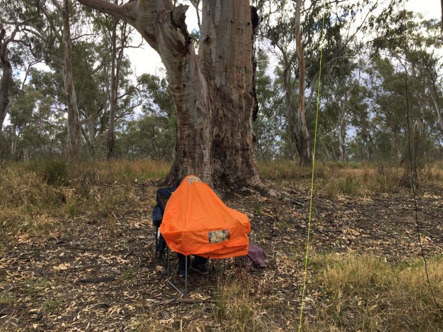
Above:- Seeking shelter underneath the bothy bag.
I worked the following stations on 40m SSB:-
I worked the following stations on 80m SSB:-
I worked the following stations on 20m SSB:-
After packing up Marija and I drove back into Cadell and took a short drive out of town on Dalzell Road and did a bit of bird spotting/photography. There is a bird hide here which allows you to get up relatively close to the birds in the Cadell Basin, near the Murray.


We then took the ferry back over the Murray from Cadell. Some years ago there was significant debate about this particular ferry over the Murray River closing. In the Riverland region of South Australia, ferries operate in the townships of Cadell, Morgan, Swan Reach, Walker Flat, Purnong and Mannum.


Our next stop was the Bryan Creek historical lookout. It forms part of the ‘Disappearance of Henry Bryan Trail’. There are some brilliant views here to be enjoyed of the Murray. The story of Henry Bryan is a very interesting one. Henry Bryan was the youngest son of Reverend Guy Bryan of Woodham-Walter, Essex England, and house guest of the Governor of South Australia Lt. Col. George Gawler. He was part of the 1939 expedition led by Governor Gawler and the famous explorer Captain Charles Sturt to explore land along the Murray River upsteam and overland from the great North West Bend. Bryan disappeared during this ill fated journey and his body has never been recovered. Interestingly his horse made its way all the way back to Adelaide, with its hoofs having grown to enormous length.
For more info on this story, please have a look at…..
http://www.murrayriver.com.au/morgan/mt-bryan-expedition/


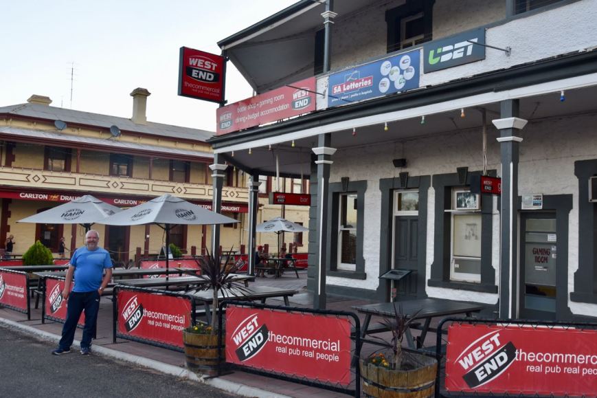
As we drove back into Morgan I logged on 14.310 from the mobile, Phil VK6ADF/p who was activating the Coomallo Nature Reserve VKFF-1849. Once we got back to Morgan we went to the Commercial Hotel for tea. This is one of two hotels that are in the town. The meal was average.
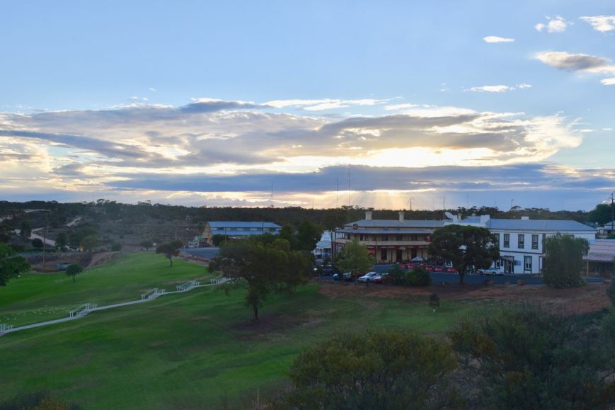
After tea we took the short drive up to the lookout to enjoy a great view of the town of Morgan, and then headed back to the motel room.
References.
Caudo Vineyards, 2017, <https://caudovineyard.com.au/about-us/>, viewed 3rd December 2017
Discover Murray River, 2017, <http://www.murrayriver.com.au/blanchetown/>, viewed 3rd December 2017
Discover Murray River, 2017, <http://www.murrayriver.com.au/morgan/>, viewed 3rd December 2017
Discover Murray River, 2017, <http://www.murrayriver.com.au/morgan/mt-bryan-expedition/>, viewed 3rd December 2017
Wikipedia, 2017, <https://en.wikipedia.org/wiki/Morgan,_South_Australia>, viewed 3rd December 2017
The 2017 VKFF Activation took place on Saturday 25th and Sunday 26th November 2017. This annual event is very popular and is all about promoting the World Wide Flora & Fauna (WWFF) program down here in Australia. Marija and I had planned to activate 4 parks in the Riverland region around the Morgan area, and we had booked in to stay at Morgan for 2 nights.
Marija took the Friday (24th November 2017) off work, and I was on holidays, so we headed up to Morgan on Friday morning. There are a few ways for us to get to Morgan from our home in the Adelaide Hills, but we chose to take the Birdwood, Sedan, Blanchetown route.
After travelling through Mount Pleasant we started heading down the hills towards the Angas Valley. There are some nice views to be enjoyed as you head down the Angas Valley Road. The Angas Valley was once a small settlement back in the late 1800’s of Prussian settlers.


We then travelled north through the town of Cambrai along the Ridley Road until we reached the small town of Sedan, about 110 km north east of Adelaide. Sedan is located about half way between the Barossa Valley and Swan Reach on the River Murray. The town was proclaimed in 1870 and was named Sedan by one of the first settlers, J.W. Pfeiffer, after a town in France in honor of the great Prussian (German) victory in the Franco-Prussian war of 1870.
There are a number of historic buildings located in the town, and we took the time to have a bit of a drive around the town admiring these, and taking a few photographs.
Here is a link to an excellent website which tells the story of the history of Sedan…..
http://www.sedan.sa.au/town-history/


We continued on to Annadale, located at the corner of Ridley Road and the Sturt Highway. There are some pepper trees here which was the site of the Annadlae Hotel and Cafe, known as ‘Halfway House’ which operated from 1876-1957. There is also an installation here, which I suspect has something to do with aircraft, which has a very nice dipole system. I admired the two towers and wished I had them in my backyard.


We then drove east on the Sturt Highway and soon reached the southern boundary of the Brookfield Conservation Park, VKFF-0822 which borders the Highway. I have activated and qualified this park previously, but Marija had not activated the park. So we decided to call into the park for a quick activation.
Brookfield is located about 130 km north east of Adelaide, and about 15 km west of the town of Blanchetown.
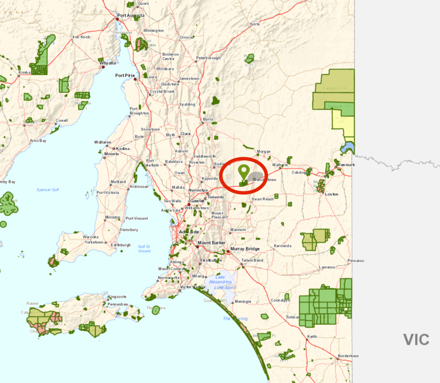
Above:- Map showing the location of the Brookfield Conservation Park. Map courtesy of Location SA Map Viewer.
The Brookfield Conservation Park is a large park, consisting of 5,515 hectares. It is managed by Conservation Volunteers Australia. Some areas of the park are restricted to the public and permission to enter those areas is required. The public section of the park is open from 7.00 a.m. until sunset, 7 days a week.
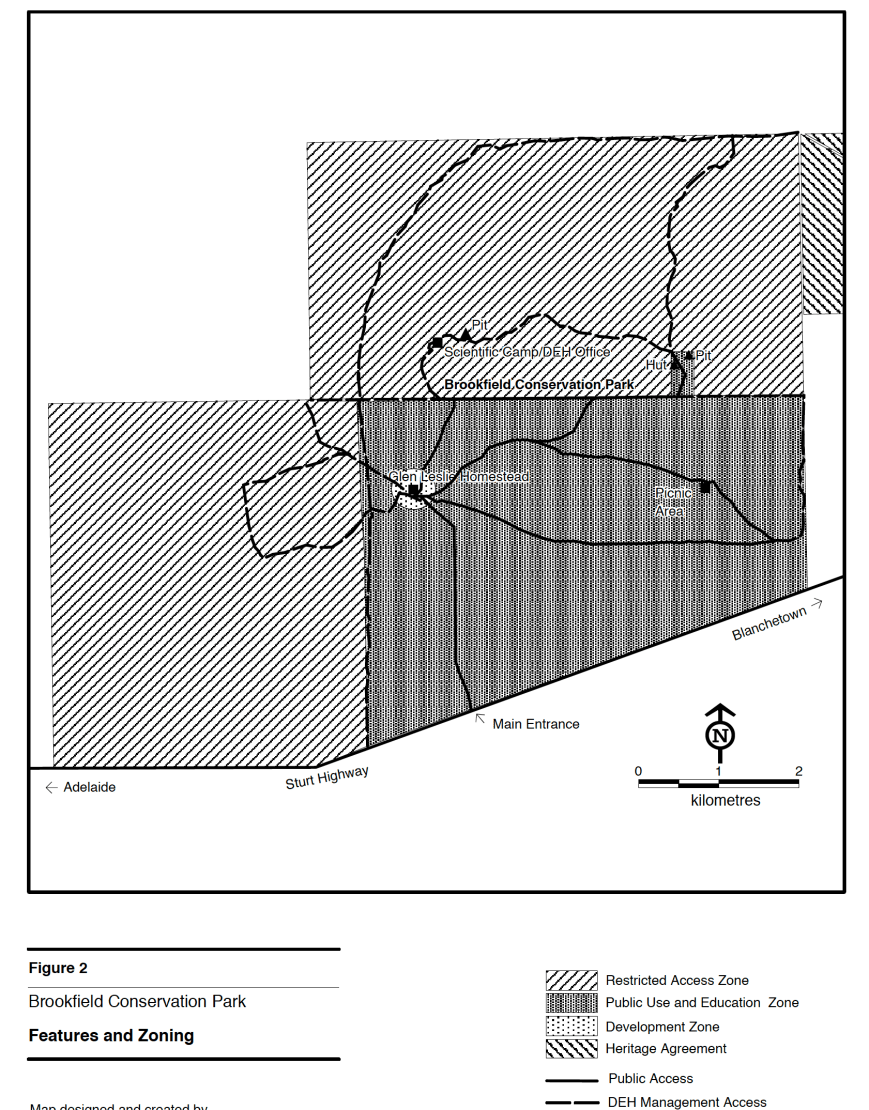
Above:- a map of the park showing the public and restricted areas. Courtesy of National Parks SA.
Various vegetation can be found in Brookfield Conservation Park. On the ridge in the northern section of the park, and extending north into the adjacent area, ridge-fruited mallee, red mallee and narrow-leaved mallee dominate over porcupine grass and sparse bitter saltbush. The northwestern corner of the park is dominated by yorrell open mallee over sparse bitter saltbush and pearl bluebush.
In the southeastern section of the park the understorey consists of a large expanse of regenerating pearl bluebush. Central areas of the park are covered by low woodland and tall shrubland typically dominated by sheep bush and sugarwood in varying densities. Dryland tea-tree is often found around claypans. The understorey is characterised by Australian boxthorn, bullock bush, caustic weed and heron’s bill.


The history of the park is very interesting. Dr. Peter Crowcroft, the former Director of the South Australian Museum, and the then Director of the Brookfield Zoo in Chicago in the USA, initiated moves to purchase land for the conservation of the Southern Hairy-nosed Wombat. The land which is now the park was originally a large sheep station known as Glen Leslie Station. In 1971 the Chicaho Zoological Society purchased the station and renamed the property as the Brookfield Zoo Wombat Reserve.

In 1977, due to rising finanical costs, the Reserve was gifted to the South Australian State Government. In August 1977 the then Department for the Environment assumed financial and managerial responsibility for the reserve and on the 6th July 1978 the reserve was proclaimed as the Brookfield Conservation Park.
The Southern Hairy-nosed Wombat is one of three species of wombat found in Australia, and is the smallest of all three species. It can be found from the eastern Nullabor Plain to the New South Wales border region. Among the oldest southern hairy-nosed wombats ever documented were a male and a female from Brookfield Zoo. Their names were Carver, which lived to be 34, and his mother, Vicky, which lived to be 24
Other native animals found in the park include the Fat-tailed Dunnart, Common Dunnart, Red Kangaroo, and Western Grey Kangaroo. About 141 species of native bird have been recorded in the park including Crested Pigeon, Brown Treecreeper, Purple-backed Fairywren, Splendid Fairywren, Southern Whiteface, Yellow-rumped Thornbill, Chestnut-rumped Thornbill, and Australian Magpie.
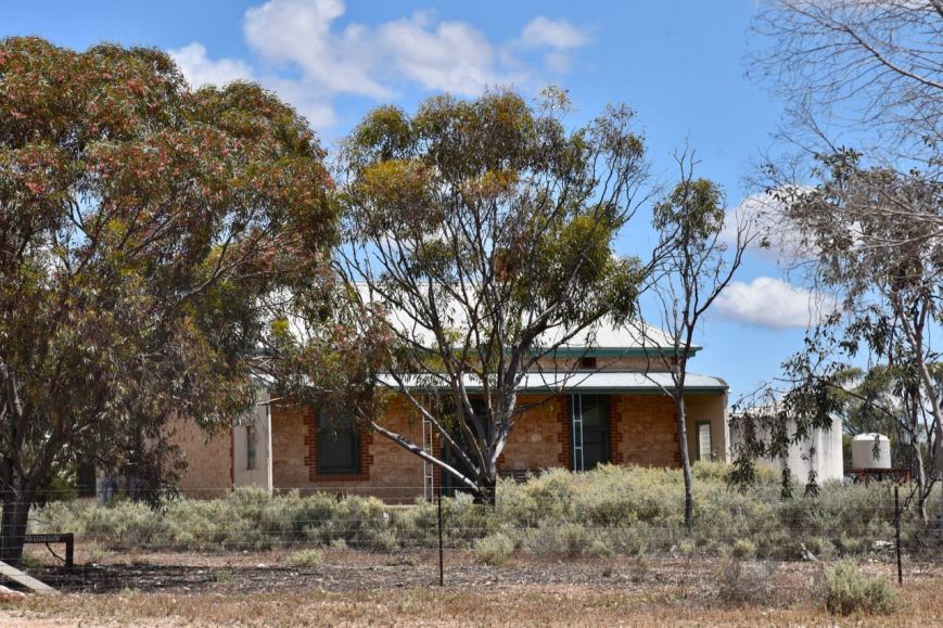
Below is a photograph of the old Glen Leslie Homestead which can be found in the park. There are eco-tourism ventures which take people out to Brookfield for wombat monitoring, with the homestead providing accomodation.
During our visit to the park there was plenty of evidence of wombat activity, with lots of burrows. Wombats are excellent diggers, with their burrows measuing from 3 to 30 metres in length and up to 3.5 metres deep.


Marija and I entered the park through the closed (but unlocked gate) off the Sturt Highway. There is a dirt track here which leads through the park, which is in good condition.


Marija and I drove a short distance down the track and set up alongside of the information board, which offered some shade from the heat of the day. It was only mid morning, but it was already quite warm.
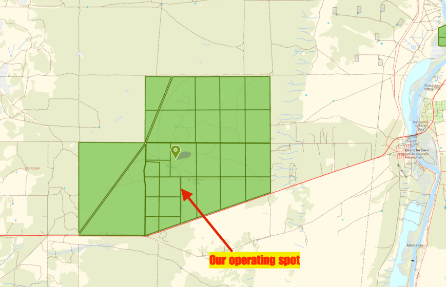
Above:- Map showing our operating spot in the park. Map courtesy of Location SA Map Viewer.
I spotted Marija on parksnpeaks and sent out a few SMS messages, whilst Marija called CQ on 7.144. Her first station in the log was John VK5BJE who was 5/9 plus into Brookfield. John reciprocated with a 5/9 for Marija. This was followed by Marc VK3OHM who was also 5/9 plus, followed by park regular Rick VK4RF/VK4HA.
But it was really hard going, with very few callers. It took Marija 25 minutes to get 10 contacts in the log. That being a contact with Hans VK5YX from the southern suburbs of Adelaide who was 5/9 plus. Marija logged 2 further stations, Adrian VK5FANA and Nick VK3ANL, before we decided it was time to pack up and head off to Morgan.
Marija had qualified the park for the VKFF program, with 12 contacts, albeit under very difficult conditions.


As it had been so slow going for Marija, I had sent out a few SMS messages to some of the park ‘die-hards’ to advise that Marija was on 7.144. One of those was Jonathan VK7JON, who had advised he was mobile and that he was on 10m. So on our way out of the park I tuned across the 10m band but could not hear anyone. I decided to put out a few CQ calls from the mobile on 28.490 on the 10m band, and this was answered by Rick VK2RR who was a good 5/7. I then tried 7.144 from the vehicle and logged Tony VK5MRT, Barry VK5KBJ and Ivan VK5HS, before reaching the boundary of the park. It was great to get a few contacts from the mobile, particularly the contact on 10m.
Marija worked the following stations on 40m SSB:-
I worked the following station on 10m SSB (from the mobile):-
I worked the following stations on 40m SSB (from the mobile):-
References.
Birds SA, 2017, <https://birdssa.asn.au/location/brookfield-conservation-park/>, viewed 2nd December 2017
Flinders Ranges Research, 2017, <https://www.southaustralianhistory.com.au/angasvalley.htm>, viewed 3rd December 2017
National Parks South Australia, 2017, <https://www.environment.sa.gov.au/parks/find-a-park/Browse_by_region/Murray_River/brookfield-conservation-park>, viewed 2nd December 2017
Sedan Progress Association, 2017, <http://www.sedan.sa.au/town-history/>, viewed 2nd December 2017
Wikipedia, 2017, <https://en.wikipedia.org/wiki/Southern_hairy-nosed_wombat>, viewed 3rd December 2017
Wombat Information Centre, 2017, <http://www.wombania.com/wombats/wombat-burrows.htm>, viewed 3rd December 2017
Amateur Radio, Short Wave Listening, travel and history
Amateur radio experiences with VK1DA
Brisbane - Australia
german amateur radio station
Summits On The Air
SOTA on the peaks, wilderness QRP and some bushwalking
A fine WordPress.com site
Amateur Radio Adventures
Summits on the Ai
Amateur radio station from Belgium
Radio craft, homebrew, QRP/SOTA, AM
Ego loqui ad viros super montes
My adventures with Amateur Radio and Geocaching!
The rantings of VK2GAZ on his SOTA experiences in Australia
A survivor, with minor cuts and abrasions.
The Art and Craft of Blogging
The latest news on WordPress.com and the WordPress community.
Blog of Justin Giles-Clark VK7TW's SOTA and amateur radio adventures.
Occasional SOTA & Microwave operation
