Mount Arapiles VK3/ VW-022 and Mount Arapiles/Tooan State Park VKFF-0765

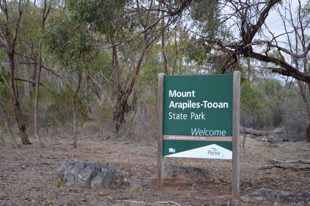
Early on Tuesday evening (29th March 2016), after booking in to my motel, I decided to head out to Mount Arapiles for an activation for both the Summits on the Air (SOTA) program and the World Wide Flora Fauna (WWFF) program.  The Mount Arapiles summit, VK3/ VW-022 is located within the Mount Arapiles-Tooan State Park VKFF-0765.

Screenshot 2016-04-05 09.51.13

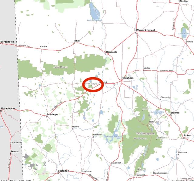
Above:- Map showing the location of Mount Arapiles in western Victoria.  Map courtesy of Forest Explorer.

The summit and park is just a short 25 km drive west of Horsham, out along the Wimmera Highway.  It is located about 10 km west of the little town of Natimuk, which is where my Nana spent her final years before passing away aged 96 years.

Screenshot 2016-04-05 09.52.41

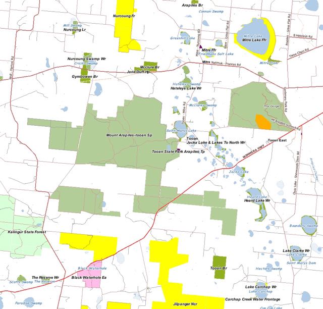
Above:- Map showing the location of Mount Arapiles in western Victoria, to the west of Natimuk.  Map courtesy of Forest Explorer.

Mount Arapiles summit is 369 metres above sea level and is worth just 1 SOTA point.  The summit has been activated a total of 11 times (including by myself back in September 2013).

Screenshot 2016-04-05 10.05.39.jpg

The Mount Arapiles-Tooan State Park has been activated a total of 4 times.  The last time I activated the SOTA peak, the park was not part of the WWFF program, so this was to be a unique park activation for me.

Screenshot 2016-04-05 10.09.02

Mount Arapiles, known as Djurite for the local Dhurid Balud aboriginal people, is one of Australia’s best rock climbing areas and rises very sharply from the Wimmera plains.  It is world renowned and has more than 2,000 developed routes on the many cliffs, crags and pinnacles.  The park, which is 7,475 hectares in size, was created in 1987.

The first recorded ascent of Mount Arapiles was on the 23rd day of July 1836, by Major Thomas Mitchell, who was the European who discovered the summit.  He named the summit after the Arapiles hills near Salamanca in Spain, where the Battle of Salamanca took place, and where Mitchell had seen action.

Mitchell said the following in his diary on the 22nd July 1836…..

“This certainly was a remarkable portion of the earth’s surface, and rather resembled that of the moon as seen through a telescope.”

A total of 14% of Victoria’s flora species are represented in the park.  The Peregrine Falcon, which can reach speeds of up to 389 kmh, can be found at Mount Arapiles.

Peregrine_falcon_(Australia)

Above:- Peregrine Falcon.  Image courtesy of wikipedia.

As I drove to west, it looked very gloomy and I could see some shower activity around Mount Arapiles.  Fortunately as I got closer, the rain band had moved away from the area of the summit/park.

The park is well sign posted off the Wimmera Highway, and a bitumised road leads to a carparking area at the top of the summit.

DSC_0031

I parked the 4WD in the carpark and then lugged the gear up the flight of steps to the trig point (a distance of around 50 metres).


Once at the top I set up just to the north of the trig point and fire tower.

Screenshot 2016-04-05 09.58.44

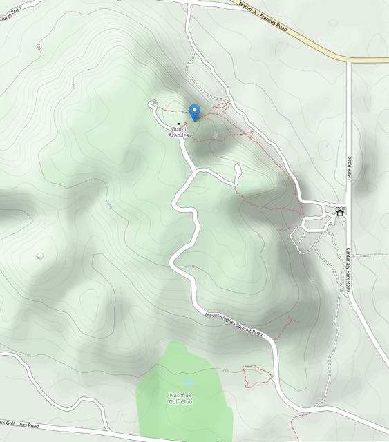
Above:- Map showing the road leading up to the summit.  Courtesy of OpenStreetMap.

After setting up I took the opportunity of taking some photographs prior to it getting dark.  There are terrific views in all directions from the top of the summit.

This slideshow requires JavaScript.

At 7.20 p.m. Victorian local time I commenced calling CQ on 7.090 and it wasn’t long for a mini pile up to commence.  The first caller of the activation was Peter VK3PF, followed by Brian VK3BBB, Col VK3LED, and then Mike VK5FVSV.  The 40m band was in excellent condition, with strong signals from all across Australia: VK1, VK2, VK3, VK4, VK5, and VK6.  I also received three calls from New Zealand: Andrew ZL3CC in Christchurch, Ken ZL4KD in Christchurch, and ZL3NF in Timaru.

I was thrown a bit by one call, and that was VK5/HF9ZZ.  It was Jack from Poland who is on holidays in South Australia.

I also managed a park to park contact with Rob VK4AAC/3 who was in the Echuca Regional Park VKFF-0966.  Sadly there were no summit to summit contacts to be had.

After 50 minutes on the summit/in the park, it was dark, and I had a total of 50 contacts in the log.  I had qualified the SOTA peak and also the park for both the VKFF and WWFF programs.

The following stations were worked:-

Screenshot 2016-04-05 09.41.06.jpg


References.

Parks Victoria, June 2014, Mount Arapiles-Tooan State Park

Wikipedia, 2016, <https://en.wikipedia.org/wiki/Mount_Arapiles&gt;, viewed 5th April 2016


Kelvin Powrie Conservation Park 5CP-103 and VKFF-0899

Last week I had to travel to Victoria to attend a funeral in Horsham in the Wimmera region of Victoria.  One of my Uncles had been battling cancer for some time and succumbed to the illness.   So to break up the drive I decided to activate the Kelvin Powrie Conservation Park (CP), 5CP-103 and VKFF-0899 on Tuesday 29th March 2016.  That morning I had attended a morning coffee session in Mount Barker with other amateurs, so straight after coffee I headed east towards the Victorian border.

Kelvin Powrie Conservation Park is situated about 217 km south east of Adelaide, and around 8 km north west of the town of Keith.

Screenshot 2016-04-05 08.36.31


Above:- Map showing the location of the Kelvin Powrie Conservation Park in the South East of the State.  Image courtesy of Location SA Map Viewer.

I had activated Kelvin Powrie CP previously (back in November 2014) for the VK5 National and Conservation Parks Award, but the park was now part of the World Wide Flora Fauna (WWFF) program, so this was to be a unique VKFF activation for me.

The park consists of an area of about 17.66 hectares and was gazetted in 1971.  It is a narrow strip of scrub located between the busy Dukes Highway (main Highway between Adelaide-Melbourne), and the Adelaide-Melbourne rail line. The park was named after James Kelvin Powrie (1926-1968), who was an agricultural scientist.  Powrie undertook research into what minerals were required to improve the soil quality of the infertile sands of the region.  This entire region was once classified by farmers as ‘unproductive scrub’.  Powrie was one of those who helped transform the district into valueable grazing and farming land.

Sadly Powrie died in his early 40’s, on the 22d day of May 1968 as a result of a motor car accident on the 20th May near Penola.  His obituary stated:

“Kelvin Powrie was a gentleman; and nobody – student, colleague or friend – could help but be aware of it, no matter what his nationality or cultural background’.

Not doubting this individual’s achievements, but it is a little surprising that a piece of scrub was named in honour of someone who played a hand in clearing the land.

On the way to the park, as I was passing through Tailem Bend I had a chat with Luke VK3HJ who was also mobile, and Gary VK5ZK on 7.095.  As I travelled further east, between Tailem Bend and Coomandook I spoke with Ray VK3NBL in Melbourne, and then Tim VK3TJK near Bendigo.

Just prior to reaching the park I stopped off at the Ngarkat Rest Area on the Dukes Highway.  There are some interesting plaques here telling the story of the Ninety Mile Desert and the breakthroughs of the many agricultural scientists, including Powrie.

I continued a short distance up the road, until reaching the turn off on the Dukes Highway, into the park.  It is not signposted.  So don’t blink.  You will miss it.  The sign to the park is only visible once you’ve entered the carparking area.

DSC_0005

There is a nice area here, with plenty of room to park the car.  I set up just outside of the carpark, in a small clearing on the south eastern side.  I didn’t have a lot of time in the park, so I quickly set up the deck chair, the fold up table, the 7m squid pole and the remainder of the station.

DSC_0026

I was fortunate in that I had the carpark all to myself.  The sound of passing traffic on the busy Dukes Highway and the occasional train passing by were a reminder that this park is a little piece of paradise surrounded by road, rail, and farming land.

Screenshot 2016-04-04 21.38.46

Above:- A map showing my operating position in the south eastern section of the park.  Map courtesy of Location SA Map Viewer.

I headed for my nominated operating frequency of 7.144 and found that it was already occupied by Ben VK7BEN who was operating portable from the Peter Murrell State Reserve, VKFF-1146.  Ben had a good 5/7 signal so I gave him a shout.  As it turned out, this was Ben’s first time out in a park for WWFF.  Ben had an antenna issue whilst we were chatting, and Peter VK3PF took the opportunity of calling in and getting me in the log.  Kelvin Powrie CP was a unique park for Peter.

After chatting with Ben and Peter, I then headed down to 7.150 and started calling CQ and this was answered by Col VK5HCF in Mount Gambier, followed by Rob VK4AAC/3 in the Echuca Regional Park VKFF-0966.  Not bad at all, two park to park contacts in just 4 QSOs.  Despite the fact that it was  a weekday, there was a steady flow of callers, with many of the regular call signs appearing in the log.  The 40m band was in quite good shape, with signals into VK3 and around VK5 being strong.  Signals into VK2 and VK4 were strong to moderate in strength.

It was pleasing to get two QRP contacts in the log.  The first was with Damien VK5FDEC running 5 watts from the norther suburbs of Adelaide (5/9 both ways), and then Paul VK3DBP/2 also running 5 watts (5/3 sent and 5/8 received).

After working 25 stations on 40m I lowered the squid pole and removed the links in the dipole and headed to 14.310 on 20m.  I commenced calling CQ and Cliff VK2NP came up to say hello with a strong 5/8 signal from Sydney.  Cliff had also called me on 40m, and he was an S point stronger on 20m.  This was followed by Mr. Reliable, Rick VK4RF/VK4HA who was his normal 5/9, and whom kindly spotted me on parksnpeaks.  Gerard VK2IO mobile then called in, followed by Martin VK6ZMS mobile in Fremantle, and finally John VK6NU.

I was only up to contact number 31.  I had spent just under an hour in the park, and I really needed to get back on the road and continue my journey to Horsham.  I would not be qualifying the park for the global WWFF program this time around.  But I did have my 10 contacts, so I had qualified the park for the Australian (VKFF) program.

After packing up I took the time to climb the short distance to the top of the sandhill for a view accross the park.  At the start of the walk there is a small plaque to honour Kelvin James Powrie.

There is a very easy walk and the path is well maintained.  The park was alive with native flowers including Banksias and Correas, and of course the honeyeaters were out in force.  Despite the fact that it was overcast, it was quite a warm day, so I made as much noise as possible, in the hope that it might scare off any unwelcome visitors in the form of snakes.

The view from the top of the sandhill is quite impressive.  Although not really high, it gives you a very good feel for the park.  The busy Dukes Highway and the passing traffic is clearly visible to the south, and to the north of the park you can see the Adelaide-Melbourne rail line and the surrounding farm land.

I returned to the 4WD and continued on my trip towards the Victorian border.  Kelvin Powrie is a great little park, which I suspect most people would not even know about.  So if you are down in the south east, don’t forget the Kelvin Powrie Conservation Park.

The following stations were worked on 40m SSB:-

  1. VK7BEN/p (Peter Murrell State Reserve VKFF-1146)
  2. VK3PF
  3. VK5HCF
  4. VK4AAC/3 (Echuca Regional Park VKFF-0966)
  5. VK5PL
  6. VK3TJK
  7. VK5KLV
  8. VK2GAZ
  9. VK3PMG
  10. VK5FDEC
  11. VK2HHA
  12. VK3DPP/2
  13. VK5HDW
  14. VK3SIM
  15. VK3MCK
  16. VK2IO
  17. VK5FMID
  18. VK3FD
  19. VK3DAZ
  20. VK3TKK/m
  21. VK2JAZ
  22. VK2NP
  23. VK5BGN
  24. VK4RF
  25. VK4HA

The following stations were worked on 20m SSB:-

  1. VK2NP
  2. VK4RF
  3. VK4HA
  4. VK2IO/m
  5. VK6ZMS/m
  6. VK6NU

After leaving the park (and whilst between Bordertown & Keith) I heard Rob VK4AAC/3, still in the Echuca Regional Park.  Rob had such a good strong signal that I couldn’t resist calling him.  After chatting with Rob, I headed up the band a bit and called CQ again and this was answered by Grant VK5VGC, followed by Tony VK5FTVR, and then Ian VK3VIN.  Ian and I had quite a chat until I got to Kaniva in western Victoria.

After leaving Kaniva I again called CQ and spoke with Ed VK3EE and then had an enjoyable chat with Jen VK3FJEN.  As I approached Nhill I was called by  John VK5EMI, and as I entered Nhill I again spoke with Ben VK7BEN/p in the Peter Murrell State Reserve.  I continued east on the Western Highway, and as I approached Horsham I booked in to the Kandos Group on 7.093 and spoke with VK2ARK (Ron VK5MRE).


References.

Australian Society of Soil Science, 1968, ‘Soils News’ No. 24 June 1968

Coffee morning

On Tuesday 29th March 2016, I met with a number of other amateurs at Cafe Aqua at Mount Barker, for morning coffee.  This was the inaugural meeting of a monthly get together I have organised for amateurs who are interested in parks activating, SOTA, QRP, etc.

The following amateurs attended:-

  1. Paul VK5PAS
  2. John VK5BJE
  3. Peter VK5PM
  4. Gordon VK5GY
  5. Tony VK5FTVR
  6. Peter VK5PET
  7. Iain VK5ZIF
  8. Kevin VK5KS
  9. David VK5KC
  10. Bob (friend of David VK5KC)

A number of stories were shared about portable operating experiences, and information exchanged about interesting websites.

Screenshot 2016-04-04 19.51.14.png

We will hold these events each month in different locations, allowing amateurs from all across the Adelaide area to attend.  It is planned that they will be coffee mornings, and lunches, and will occasionally include a quick talk on a particular subject.

I will post details about the next meeting date and venue on the AHARS Facebook site, the VK5 Parks Facebook site, and the VKFF/SOTA Facebook site.  I also have an email list, so if you would like to be added, please send me an email to…………..

vk5pas@wia.org.au