
For the World WideFlora Fauna (WWFF) program, one of my main references for researching parks is the CAPAD data. I’ve been asked quite a bit, ‘What is the CAPAD?’ So here’s a little bit of information explaining what it is all about.
What is the CAPAD?
The Collaborative Australian Protected Areas Database (CAPAD) , released by the Department of the Environment, Australian Government, provides both spatial and text information about government, indigenous and privately protected areas for continental Australia. State and Territory conservation agencies supply data and this in turn is compiled and published in the CAPAD. The ninth version of the CAPAD database was released in 2014, with previous versions released in 1997, 2000, 2002, 2004, 2006, 2008, 2010 and 2012.
![]()
The Department also publishes protected areas data for the marine environment. This contains spatial and text information about offshore protected areas, for both State and Commonwealth waters. The most recent version was released in 2014, with previous versions of CAPAD marine information having been published in 1997, 2002, 2004, 2008, 2010 and 2012.
When and where can I find the CAPAD?
The department publishes a summary of the CAPAD data biennially on its website at http://www.environment.gov.au/capad/
What is spatial data?
Spatial data, also known as geospatial data or geographic information, is date or information that identifies the geographic location of features and boundaries on Earth, such as natural or constructed features, oceans, and more. Spatial data is usually stored as coordinates and topology, and is data that can be mapped.
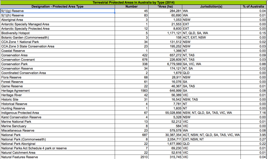
What is found in the CAPAD?
The CAPAD provides a snapshot of protected areas that meet the International Union for Conservation of Nature (IUCN) definition of a protected area:
“A protected area is an area of land and/or sea especially dedicated to the protection and maintenance of biological diversity, and of natural and associated cultural resources, and managed through legal or other effective means” (IUCN 1994).
CAPAD provides information at a national, state and territory level. For each grouping CAPAD includes information about the following:
- List of all protected areas. This list includes information on IUCN category, location (latitude and longitude of mid-point (centroid)), area (hectares) and gazettal date (the year an area was declared a protected area).
- Protected areas classified according to reservation type designations eg National Park, Conservation Covenant, Indigenous Protected Area.
- Protected areas classified according to IUCN management categories eg. Number of designated Category III protected areas in NSW.
- Protected areas classified according to type designations as a proportion of Australia’s bioregions (known as IBRA). For example, the number of type designations within the Victorian Midlands (VM) IBRA region in Victoria and the percentage of those types of Protected Areas within that region.
- Protected areas classified according to IUCN management categories as a proportion of IBRA region eg. Number of Category II protected areas in Queensland and the percentage of those IUCN categories within the Queensland IBRA regions.
- The level of protection of IBRA regions.
- The level of protection of IBRA subregions.
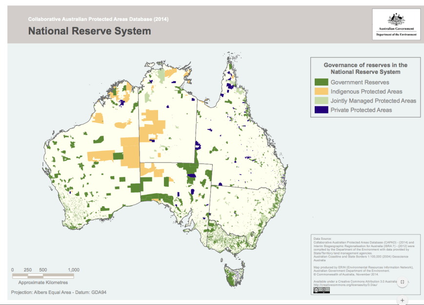
- Protected Areas classified according to governance e.g. government, joint, indigenous and private.
IUCN Protected Areas Categories System
IUCN protected area management categories classify protected areas according to their management objectives. The categories are recognised by international bodies such as the United Nations and by many national governments as the global standard for defining and recording protected areas and as such are increasingly being incorporated into government legislation.
a Strict Nature Reserve: Category Ia are strictly protected areas set aside to protect biodiversity and also possibly geological/geomorphical features, where human visitation, use and impacts are strictly controlled and limited to ensure protection of the conservation values.
Ib Wilderness Area: Category Ib protected areas are usually large unmodified or slightly modified areas, retaining their natural character and influence without permanent or significant human habitation, which are protected and managed so as to preserve their natural condition.
Ib Wilderness Area: Category Ib protected areas are usually large unmodified or slightly modified areas, retaining their natural character and influence without permanent or significant human habitation, which are protected and managed so as to preserve their natural condition.
III Natural Monument or Feature: Category III protected areas are set aside to protect a specific natural monument, which can be a landform, sea mount, submarine cavern, geological feature such as a cave or even a living feature such as an ancient grove. They are generally quite small protected areas and often have high visitor value.
IV Habitat/Species Management Area: Category IV protected areas aim to protect particular species or habitats and management reflects this priority. Many Category IV protected areas will need regular, active interventions to address the requirements of particular species or to maintain habitats, but this is not a requirement of the category.
V Protected Landscape/ Seascape: A protected area where the interaction of people and nature over time has produced an area of distinct charcter with significant, ecological, biological, cultural and scenic value: and where safeguarding the integrity of this interaction is vital to protecting and sustaining the area and its associated nature conservation and other values.
VI Protected area with sustainable use of natural resources: Category VI protected areas conserve ecosystems and habitats together with associated cultural values and traditional natural resource management systems. They are generally large, with most of the area in a natural condition, where a proportion is under sustainable natural resource management and where low-level non-industrial use of natural resources compatible with nature conservation is seen as one of the main aims of the area.
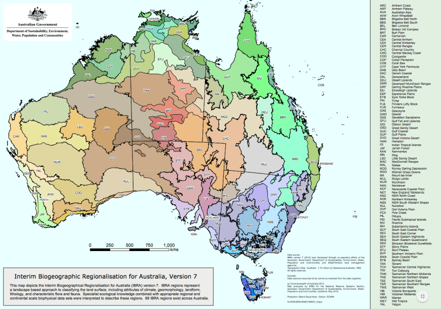
What is IBRA?
The Interim Biographic Regionalisation for Australia (IBRA) was developed in 1993-94 and is endorsed by all levels of government as a key tool for identifying land for conservation. The latest version, IBRA7, classifies Australia’s landscapes into 89 large geographically distinct bioregions based in common climate, geology, landform, native vegetation and species information, e.g. Australian Alps, the Nullabor Plain, the Wet Tropics, etc.
References.
Australian Government, Department of the Environment, <https://www.environment.gov.au/land/nrs/science/capad/2014>, viewed 13th July 016
International Union for Conservation of Nature, <http://www.iucn.org/theme/protected-areas/about/categories>, viewed 13th July 2016

Hi Paul,
About three quarters of our property is under a SA Heritage Agreement. We made the decision to do this a few years back. We cannot chop down trees or change the area in any way. We have also done quite a bit of weeding. Our property adjoins another one which also has a Heritage Agreement. So we have a private park and with the adjoining property we have quite a large area for native animals. We excluded the area around and in front of our house. So most of our place is a Private Park. I immediately thought I could activate it as a Park!
cheers
John D
VK5BJE/VK5PF
Hi John,
The Dawes Conservation Park?
Cheers,
Paul.
Paul,
That’s an interesting read and heartening to know such a structure exists.
John,
That’s superb what you have done, must visit again one day!
Chris
VK4FR
G’day Chris,
I’m looking forward to the 2016 data coming out. I’ve spoken to the Dept Environment people and they plan to release the data at the end of the year.
Cheers,
Paul,
VK5PAS.