Sturt Gorge Recreation Park VKFF-1750

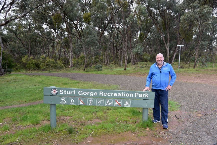
Today (Sunday 23rd July 2017) Marija VK5FMAZ and I activated the Sturt Gorge Recreation Park VKFF-1750.  The park is located about 13 km south of Adelaide.

It was quite a miserable day compared to the day before which was bright and sunny.  But despite the rather gloomy weather, we decided to head out.  We had attended a friend’s house the night before for dinner for an event called ‘The Longest Table’, the Hospital Research Foundation’s annual cancer fundraiser.  I had indulged in more than a bit of red wine, so I figured some fresh air would be of benefit to me

Screen Shot 2017-07-23 at 8.59.11 pm.png

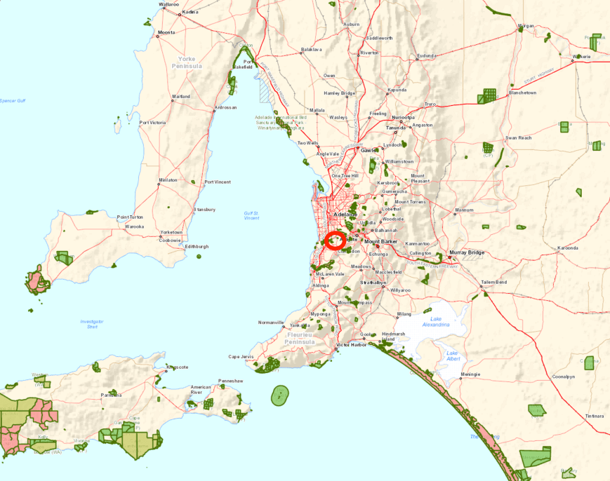
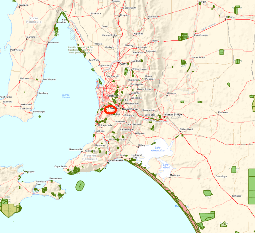
Above:- Map showing the location of the Sturt Gorge Recreation Park.  Map courtesy of Location SA Map Viewer.

The Sturt Gorge Recreation Park is 244 hectares (600 acres) in size and was established on the 4th October 1973.  The park lies between the suburbs of Bellevue Heights and Flagstaff Hill along the Sturt River.

DSC_7671

During the 1964, Mr. Robin Millhouse, the Member for Mitcham (later to become the Attorney General of SA) raised the issue in Parliament of acquiring Sturt Gorge for use as a National Park.  In a letter to the Minister of Lands dated 6th August 1964 Millhouse stated:

“The area I have in mind is that below the flood control dam site.  I am sure you would agree that it is most suitable for a National Park”.

Unfortunately no action was taken by the Government, and in January 1966, Millhouse again raised the question with the new Minister of Lands, Mr. J.D. Corcoran.  They both visited the area and later requested action be taken under the Town Planning Act to ensure that no subdividing for housing took place in the area.  Unfortunately no powers exited at the time for this, and several applications to subdivide were received in 1965-1966.

Millhouse then had discussions with the de Rose family who owned the land and found the property was available for sale at the price of 70,000 pounds.  Millhouse conveyed this information to the State Government who replied stating:

“The present Government is unable to contemplate the purchase of the area at this stage”.

In June 1966, Millhouse again raise the matter in Parliament, and in the following month, the de Rose family were approached by land developers and subsequently sold the land.  Millhouse continued to apply pressure, and was supported by a campaign by the Geological Monuments Subcommittee of the S.A. Division of the Geological Society of Australia.  Between 1969 and 1972, the applied pressure appears to have paid off, with the State Government purchasing in pieces the land from the two development companies.  In 1973 the Sturt Gorge was proclaimed as a Recreation Park.

c6bca0b9a038951dc3f4c8f223fcaabd.jpg

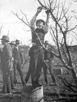
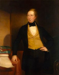
Above:- Robin Millhouse.  Image courtesy of http://www.adelaidenow.com.au

The park is internationally recognised as an area of conservation and geological significance.  Sturt Gorge conserves the nationally threatened greybox grassy woodland vegetation which was once abundant across southern Australia.  It is the second largest remnant area of grey box open woodland managed by the Department of Environment Water & Natural Resources.  Along the Sturt River there are numerous River Red Gums.  North of the river there are areas of drooping sheaoak woodland over twiggy daisy-bush and sticky hop-bush.  At the western end of the park the habitat is mostly exotic with some native grasses.

The park is also home to a rock formation, known as sturt tillite, that is believed to have been formed from glacial material dropped from ice floating in the ocean that covered South Australia 800 million years ago.

Screen Shot 2017-07-23 at 9.56.47 pm.png

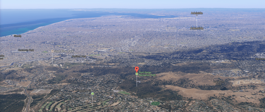
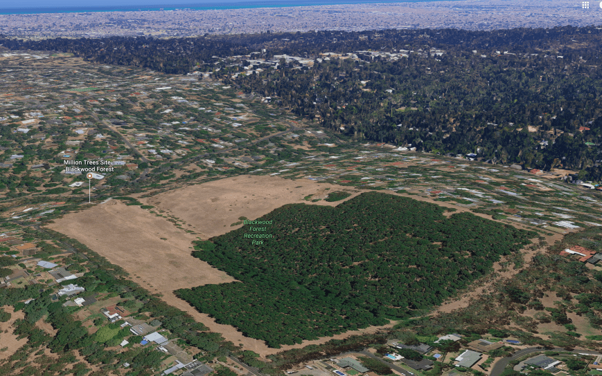
Above:- Aerial view of the park, in close proximity to Adelaide.  Image courtesy of Google maps

The Sturt River, also known as Warri Parri, carves its way through the park.  The river rises in Upper Sturt and flows through Corromandel Valley, the Sturt Gorge Recereation Park, the southern suburbs of Marion and Morphettville, before meeting the Patawalonga River in Glenelg North, the end of its 27 km course.  It was named after the famous explorer, Captain Charles Sturt.

Charles_Sturt_by_John_Michael_Crossland_lowres_color.jpg

Above:- Captain Charles Sturt.  Image courtesy of wikipedia.

The Sturt River Flood Control Dam can be located in the park.  It is well worth a look, as there are some great views of the gorge from the 40 metre high dam wall.  But beware, the walk back up to the car park area is quite steep.

Over 115 species of bird have been recorded in the park including Crimson  Rosella, Superb Fairywren, New Holland Honeyeater, Red Wattlebird, Whiteplumed honeyeater, White-browed Babbler, Grey Shrikethrush, Peregrine Falcon, and Sacred Kingfisher.

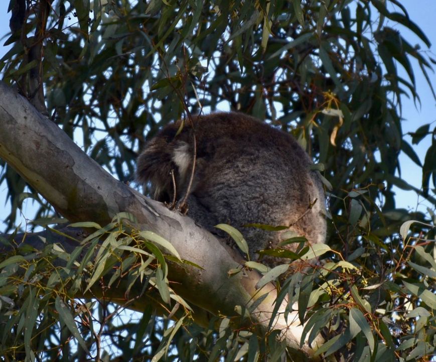
The park is also home to a large amount of native wildlife including kangaroos and koalas.

For more information on the park, have a look at the Friends of Sturt Gorge website at…..

http://www.fosg.org.au/park.html

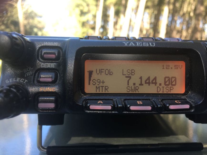
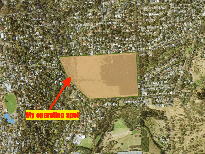
Marija and I operated from inside gate 20 at the end of Craigburn Road.  We ran the Yaesu FT-857d (set at 10 watts PEP for Marija, and 40 watts for me), and the 80/40/20m linked dipole supported on the 7 m squid pole, inverted vee.

Screen Shot 2017-07-23 at 8.57.16 pm.png

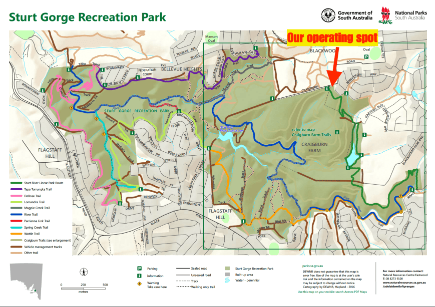
Above:- Map of the Sturt Gorge Recreation Park showing our operating spot.  Map courtesy of National Parks South Australia.

This was to be a unique park for both Marija and I for the World Wide Flora Fauna (WWFF) program.  Marija started off the activation and was content in obtaining 10 QSOs, qualifying the park for the VKFF program.  We headed to our nominated operating frequency of 7.144 and found Gerard VK2JNG/p who was activating the Rocky Glen National Park VKFF-1179.  We both logged Gerard, Park to Park, and then headed down to 7.135 where Marija called CQ.  Marija’s second contact was another Park to Park, this time with Peter VK3PF/p in the Glenmaggie Regional Park VKFF-1877.

Marija had soon racked up 10 contacts, thus qualifying the park for VKFF.  Contact number 10 being with Adam VK2YK.  Shortly after we also worked Neil VK4HNS/p who was activating theSpringwood Conservation Park VKFF-1653.  Marija logged a total of 13 stations from VK2, VK3, VK4,, and VK7, before we swapped the mic.

I then called CQ on 7.135, with my first taker being Lee VK2LEE, followed by Ron VK3MRH, and then Dennis VK2HHA.  Contact number 10, with Steve VK7CW, soon followed.  Despite it being a Sunday, there was not the normal flurry of callers.  Band conditions also seemed to be down a little, with quite a bit of QSB on the signals.  But despite this, I logged my 44th contact, a little over an hour into the activation.  Contact number 44 was with Murray VK3MJT.

Whilst I was on air, Marija had a number of chats with interested onlookers, explaining what we were doing and all about the hobby of amateur radio.  Park activating is always a great way of promoting the hobby.

I logged a total of 46 stations on 40m from VK2, VK3, VK4, VK5, VK6, and VK7, before we lowered the squid pole, and inserted the 80m links.  I called CQ on 80m with John VK5BJE coming back with a very solid 5/9 + signal.  But sadly John was my only caller on 80m.

The weather was becoming quite threatening, and it was a chilly 13 deg C, so I quickly tried my luck on 14.310 on the 20m band.  Anthony VK6MAC was my first caller there with a good strong 5/8 signal from Western Australia, followed by Fred VK4FE in far north Queensland, and then Hans VK6XN.  Sadly I had to go QRT very quickly with Hans as the heavens opened up.  It was mad dash to pack up the gear and head back to the vehicle.

It was time to head home.  We had both successfully qualified the park for VKFF and I had also achieved 44 QSOs, qualifying the park for the WWFF global program.  And a brand new park to add to our activator list.  Thanks to everyone who called.

Marija worked the following stations on 40m SSB:-

  1. VK2JNG/p (Rocky Glen National Park VKFF-1179)
  2. VK3PF/p (Glenmaggie Regional Park VKFF-1877)
  3. VK3IRM
  4. VK2PKT
  5. VK7NWT
  6. VK3FSPG
  7. VK3MPR
  8. VK3MRH
  9. VK2HH
  10. VK2YK
  11. VK2VW
  12. VK4HNS/p (Springwood Conservation Park VKFF-1653)
  13. VK3KMH

I worked the following stations on 40m SSB:-

  1. VK2JNG/p (Rocky Glen National Park VKFF-1179)
  2. VK3PF/p (Glenmaggie Regional Park VKFF-1877)
  3. VK2LEE
  4. VK3MRH
  5. VK2HHA
  6. VK2YK
  7. VK3FSPG
  8. VK3MPR
  9. VK3SS
  10. VK7CW
  11. VK3ANL
  12. VK3ANP
  13. VK4RZ
  14. VK3SQ
  15. VK7JON
  16. VK3VIN
  17. VK4RF
  18. VK4HA
  19. VK2GZ
  20. VK2GKA/m
  21. VK2FOUZ
  22. VK3IRM
  23. VK2STO
  24. VK3FEVT
  25. VK6MAC
  26. VK2JAZ
  27. VK3CWF
  28. VK3ZPF
  29. VK5ZZ
  30. VK5TR
  31. VK3FRAB
  32. VK4SMA
  33. VK3UH
  34. VK4TJ
  35. VK4HNS/p (Springwood Conservation Park VKFF-1653)
  36. VK3KMH
  37. VK4FFAB
  38. VK5YL
  39. VK2VRC
  40. VK2JNG/m
  41. VK2HPN
  42. VK3HKK
  43. VK2NP
  44. VK3MJT
  45. VK6XN
  46. VK5BJE

I worked the following station on 80m SSB:-

  1. VK5BJE

I worked the following stations on 20m SSB:-

  1. VK6MAC
  2. VK4FE
  3. VK6XN


References.

Birds SA, 2017, <http://www.birdssa.asn.au/location/sturt-gorge-recreation-park/&gt;, viewed 23rd July 2017

Friends of Sturt Gorge, 2017, <http://www.fosg.org.au/index.html&gt;, viewed 23rd July 2017

National Parks South Australia, 2017, <https://www.environment.sa.gov.au/parks/Find_a_Park/Browse_by_region/Adelaide/sturt-gorge-recreation-park&gt;, viewed 23rd July 2017

Wikipedia, 2017, <https://en.wikipedia.org/wiki/Sturt_Gorge_Recreation_Park&gt;, viewed 23rd July 2017

Wikipedia, 2017, <https://en.wikipedia.org/wiki/Sturt_River&gt;, viewed 23rd July 2017

Blackwood Forest Recreation Park VKFF-1686

Yesterday (Saturday 22nd July 2017) I activated the Blackwood Forest Recreation Park VKFF-1686 which is located about 13 km south of Adelaide, in the Mount Lofty Ranges ‘Adelaide Hills’.  The park is located at Hawthorndene in the Coromandel Valley.

This was to be a unique park for me as an activator for the World Wide Flora Fauna (WWFF) program, and the very first time the park had been activated.

Screen Shot 2017-07-22 at 4.45.28 pm.png

Above:- Map showing the location of the Blackwood Forest Recreation Park.  Map courtesy of Location SA Map Viewer.

The Blackwood Forest Recreation Park was first acquired by the South Australian State Government in 1908 for use as an experimental orchard.  It continued to be used for horticultural research until the 1960s.  From the mid 1980’s there was sustained public concern over a period of more than 15 years, seeking to have the 21 hectares of land retained as open space.  This resulted in the Blackwood Forest Recreation Park being proclaimed a Recreation Park under the National Parks and Wildlife Act in November 2001.

DSC_7611

There is limited natural vegetation in the park.  Some native vegetation can be found on the eastern boundary of the park, while some old River Red Gums and Acacia species can be found along Minno Creek on the western boundary of the park.  About 8 hectares of the park is Monterey Pine, with the remainder of the park being open grassland.  A few of the original trees from the orchard remain today, including walnuts, pecans, loquats, mulberries, quinces, greenguage plums.  A row of 27 named varieties of olives can be located along the Turners Avenue boundary of the park. These olives are officially listed by The National Trust of South Australia as being locally historically important.

There are a number of walking tracks in the park, and as it was a beautiful sunny day there were a lot of bushwalkers, people out with their dogs, and mountain bikers in the park.  There are also a number of interpretive signs.

DSC_7615

In 1908, the land which is now the park, was purchased by George Quinn, Chief Horticultural Instructor with the then newly formed Department of Agriculture for £88 , for the purpose of establishing an experimental orchard to trial and experiment with a wide range of fruit trees.

Quinn,_George_1918

Above:- George Quinn demonstrating pruning techniques in 1918.  Courtesy of http://www.pir.sa.gov.au

Over 4,000 varieties of fruit trees were counted in a census in 1927.  The orchard was considered to be the largest collection of fruit varieties in one plantation anywhere in the world.   However, in the late 1930s, problems with soil erosion and fertility led to the orchard being mainly replanted with varieties more suited to the local climate.  Orcharding in the area declined in the 1960s and resources were progressively transferred to a new facility at Lenswood.   In 1968 the Blackwood orchard ceased.

image008.jpg

The former manager’s house dating back to c. 1909 can still be found in the western section of the park.

In 1985 and 1993, South Australian State government plans to rezone and sell off the land, resulted in community protest meetings and petitions demanding that the land be retained in perpetuity as public open space.  In 1993 the Save the Blackwood Forest Committee was formed and maintained consistent pressure on a succession of ministers over the following years.  There were a number of protest rallies and marches, public meetings, community tree plantings and tent embassies on the land.  In 2001, after a long and difficult struggle, the Blackwood Forest Reserve was declared permanent open space as part of the Greater Mount Lofty Parklands.

There is an active Friends of Blackwood Forest Recreation Park.  Their website can be located at…..

http://www.communitywebs.org/friendsofblackwoodforest/history.php

Screen Shot 2017-07-23 at 8.38.34 pm.png

Above:- Aerial shot showing the park, with Adelaide in the background.  Image courtesy of Google maps

Over 40 species of birds have been recorded in the park including Maned Duck, Adelaide Rosella, Eastern Rosella, Rainbow Lorikeet, New Holland Honeyeater, Spotted Pardalote, Eastern Spinebill, and Laughing Kookaburra.

Various native wildlife can be located in the park including koalas, Echidnas, Common Brushtail Possum, and Common Ringtail possum.  During my activation I had a koala in the gum tree above me, enjoying the afternoon sun.

DSC_7623

Above:- Koala having an afternoon sleep in the gum tree above my operating spot.

My initial operating spot in the park was alongside of the pines, at the northern end of Myrtle Road.  Sadly after setting up and switching on the transceiver I found that there was S9 plus noise.  It was impossible to operate from this position, so I pack up and headed off to find a quieter location.

IMG_0360

Above:- S9 plus noise at my first spot in the park.  Unworkable!!!!

I then travelled along Turners Avenue and parked in the carpark near the junction with Main Road.  I set up about 50 metres inside the park boundary in a nice cleared area.  As it was a warm sunny day, I set up the fold up table and deck chair under the shade of some nearby trees.

Screen Shot 2017-07-22 at 4.45.00 pm.png

Above:- Aerial shot of the park, showing my operating spot in the western section of the park.  Image courtesy of Location SA Map Viewer.

Prior to calling CQ I tuned across the 40m band and found Gerard VK2JNG/p on 7.135.  Gerard was in the Cooleburba State Conservation Area VKFF-1307.  It was a nice way to start the activation with a Park to Park contact.  I then found Mark VK4SMA/p on 7.144, in the Denmark Hill Conservation Park.  Mark was quite low down, as I was to he, but as we both had zero man made noise, we were able to work each other comfortably.

I then headed to 7.130 and called CQ.  But not before sending my wife Marija VK5FMAZ a text message to let her know I was on 7.130.  Marija was at home patiently waiting for me to come up, before heading off to do the shopping.  I was pleased to be able to hear Marija back at Mount Barker on the other side of the hills, as close in propagation on 40m has been challenging to say the least, over the past few months.  Scott VK7NWT then called in with a nice 5/9 signal, followed by Peter Vk3PF, Don VK3MCK, and then Dennis VK2HHA.

Contact number 10, qualifying the park for me for the VKFF program, was Garry VK3VLA at Geelong.  I continued to work a steady flow of callers, with contact number 44 being reached whilst 1 hour & 15 minutes into the activation.  Lee VK2LEE was my 44th contact, qualifying the park for me for the global WWFF program.

With 44 contacts in the log I headed over to 3.610 on the 80m band, where I logged Geoff VK3SQ in Beechworth, Mike VK5FMWW in the southern suburbs of Adelaide, and finally John VK5BJE in the Adelaide Hills.  It was quite noisy on the 80m band from the park, with a noise floor of around strength 7.

I then tried my luck on 20m, but 5 minutes of CQ calls went unanswered, so I headed back to the 40m band.  My first contact on returning there, was another Park to Park, with Mark VK4SMA who was now in the Ipswich Pteropus Conservation Park VKFF-1562.  I then returned to 7.130 and called CQ and logged 5 stations, all from Victoria, before going QRT.

I had a total of 53 QSOs in the log and a new park activated for the World Wide Flora Fauna program.

I worked the following stations on 40m SSB:-

  1. VK2JNG/p (Cooleburba State Conservation Area VKFF-1307)
  2. VK4SMA/p (Denmark Hill Conservation Park VKFF-1529)
  3. VK5FMAZ
  4. VK7NWT
  5. VK3PF
  6. VK3MCK
  7. VK2HHA
  8. VK3PAT
  9. VK2XXM
  10. VK3VLA
  11. VK6XN
  12. VK3AUR
  13. VK5MR/m
  14. VK4RF
  15. VK4HA
  16. VK2YW/m
  17. VK3UH
  18. VK3BBB
  19. VK3SQ
  20. VK7CW
  21. VK6POP
  22. VK5FANA
  23. VK3CM
  24. VK4TJ
  25. VK2YK
  26. VK3ARH
  27. VK3KLB
  28. VK3MKM
  29. VK5BJE
  30. VK3FOGY/m
  31. VK3NLK/m
  32. VK3TKK
  33. VK2NP
  34. VK3HBG
  35. VK3EV
  36. VK7VZ
  37. VK7AN
  38. VK6MAC
  39. VK3NU
  40. VK3WWE
  41. VK2VW
  42. VK3ELH
  43. VK3ZPF
  44. VK2LEE
  45. VK4SMA/p (Ipswich Pteropus Conservation Park VKFF-1562)
  46. VK3RV
  47. VK3WQ
  48. VK3CWF
  49. VK3ZMD
  50. VK3ANL

I worked the following stations on 80m SSB:-

  1. VK3SQ
  2. VK5FMWW
  3. VK5BJE


References.

Birds SA, 2017, <http://www.birdssa.asn.au/location/blackwood-forest-recreation-park/&gt;, viewed 23rd July 2017

Department for Environment and Heritage, 2005, Management Plan Blackwood Forest Recreation Park.

Friends of Blackwood Forest Recreation Park, 2017, <http://www.communitywebs.org/friendsofblackwoodforest/&gt;, viewed 23rd July 2017

National Parks South Australia, 2017, <https://www.environment.sa.gov.au/parks/Find_a_Park/Browse_by_region/Adelaide_Hills/blackwood-forest-recreation-park&gt;, viewed 22nd July 2017