After packing up at Onkaparinga River Recreation Park, Marija and I headed to our second park activation for Saturday 1st July 2017, the Moana Sands Conservation Park 5CP-136 & VKFF-1061. This was to be a unique park for us as activators for both the World Wide Flora Fauna (WWFF) program, and the VK5 National and Conservation Parks Award.
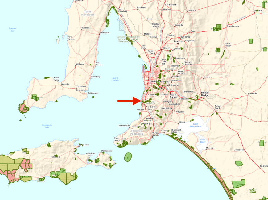
Moana Sands Conservation Park is located about 36 km south of Adelaide.
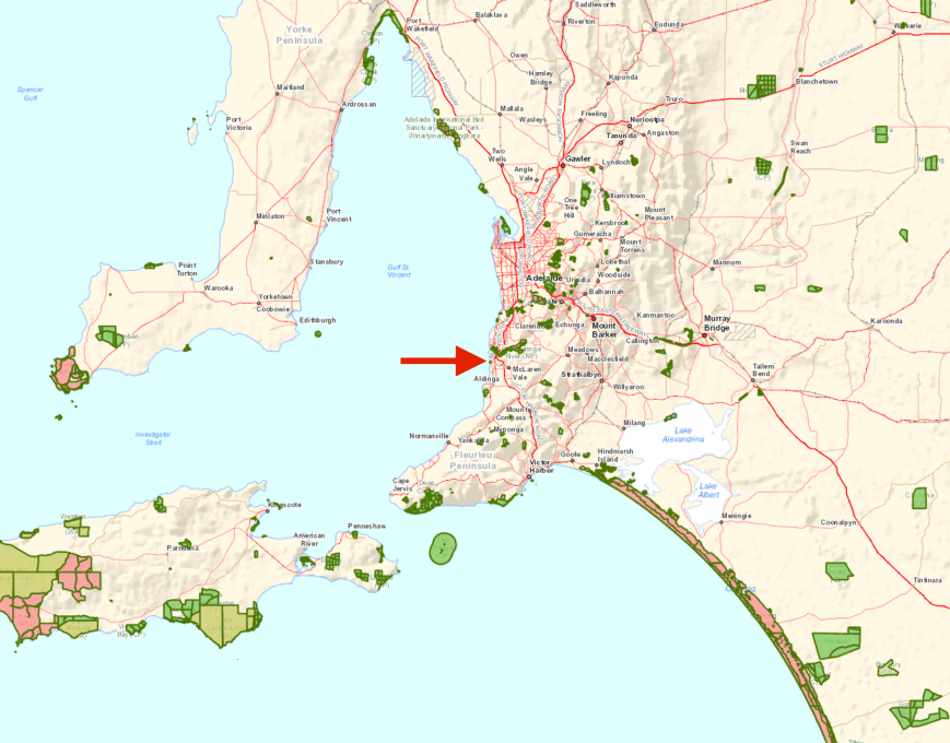
Map showing the location of the Moana Sands Conservation Park. Map courtesy of Location SA Map Viewer.
The Moana Sands Conservation Park is about22 ha (54 acres) in size and was established on the 7th November 1985. It was proclaimed under the National Parks and Wildlife Act 1972 in 1985 for the purpose of conserving a ‘significant Aboriginal cultural heritage site’ associated with the Kaurna people.
The park’s coastal sand dunes are very important in the cultural traditions of the Kaurna people who made their summer camp in the dunes next to Pedlar Creek. Many archaeological artefacts, including burial sites, hearths and shell middens – some dating back more than 6000 years – have been found where the overlying sand has blown away.
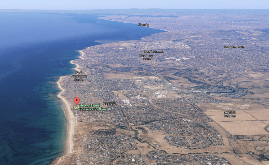
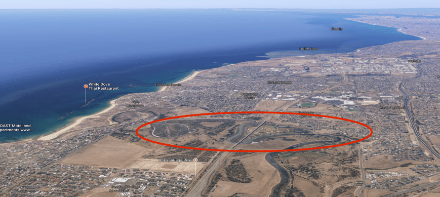
Aerial view showing the park in the southern suburbs of Adelaide. Image courtesy of Google maps
Moana was originally farming land from 1841. In the 1850s a local landowner lent his name to the beach and it became known as Dodd’s Beach. In 1855, when shipping was the primary means of cargo transport in the area, the Nashwauk was wrecked on the beach near the Pedler Creek outlet.
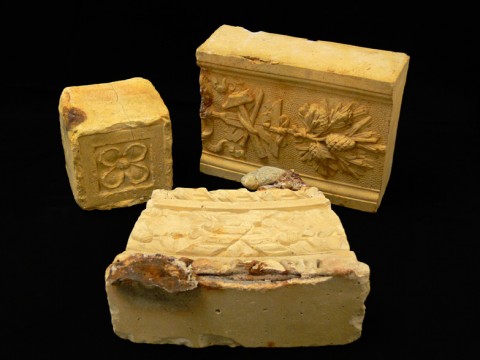
Bricks recovered from the wreck of the Nashwauk. Image c/o South Australian Maritime Museum.
Due to an increased interest in tourism in the area, in 1927 the land was subdivided by Lake Beach Estate Ltd who held a competition to name the new town. Mr C.H. Cave won the competition with Moana, which means “blue water” in the Maori language. The land was divided into blocks of land suitable for holiday homes and wide streets were planned and laid out, but due to the Great Depression in 1929 development of the area was slow.
In the 1950s Moana experienced renewed interest from tourism as the residents of Adelaide enjoyed the freedom and mobility of car ownership – Moana was a pleasant 40 minute drive from Adelaide.
The area was recorded in the 1890’s as “the greatest development of sand dunes of Gulf St. Vincent” boasting imposing dunes to 80 feet (25 metres); but within 40 years human and animal impact denuded the dunes and erosion demolished their magnificent stature.
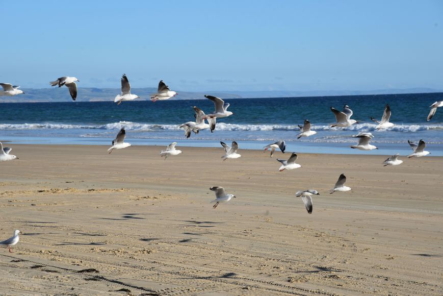
The park is home to a large variety of birdlife including the Swamp harrier and the rare Hooded Plover.


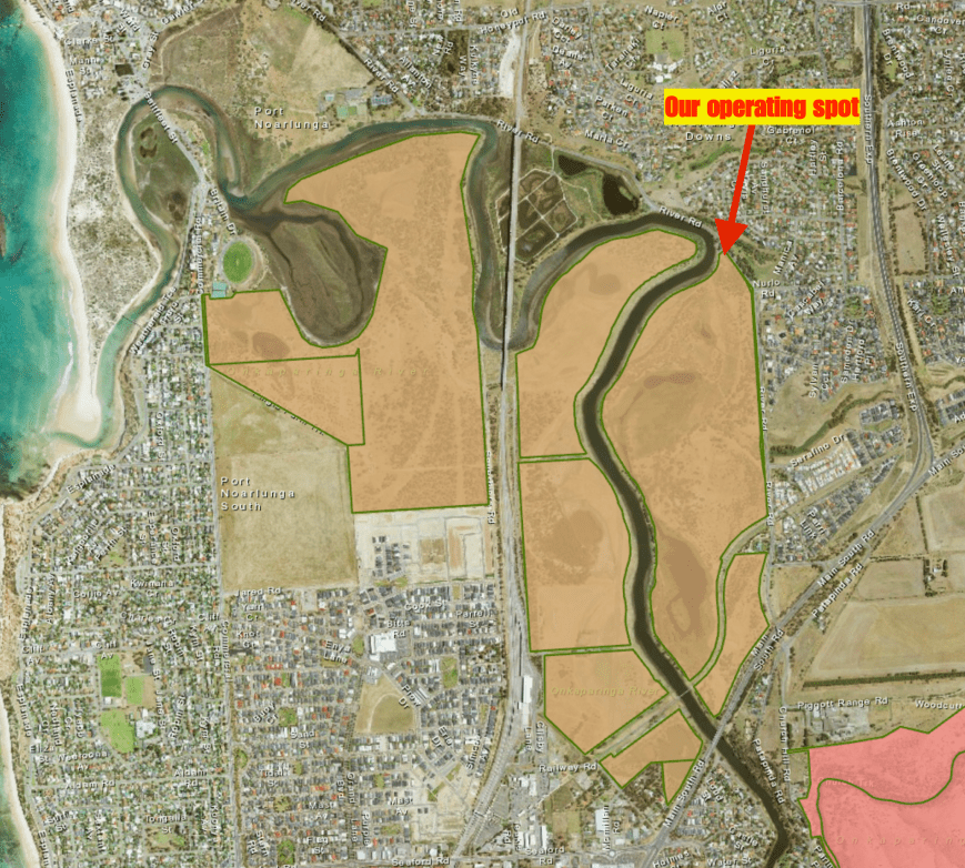
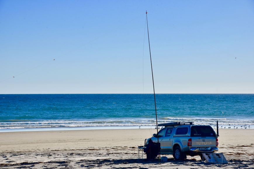
We set up on the beach just a little south of Peddler Creek. We ran the Yaesu FT-857d and the 80/40/20m linked dipole supported on the 7m telescopic squid pole.
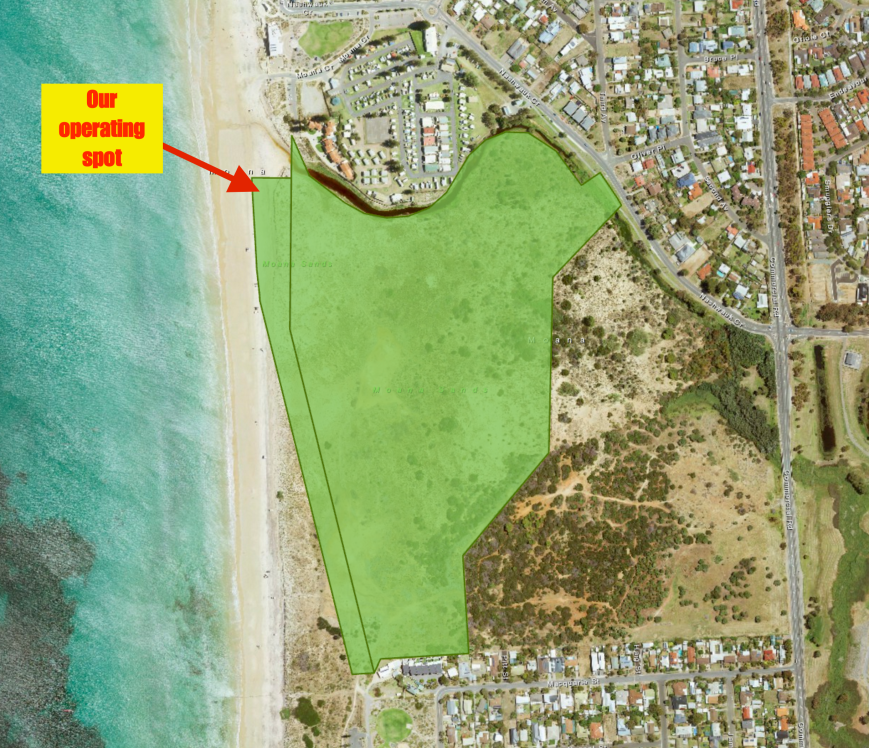
Aerial shot of the park showing our operating spot. Image courtesy of Location SA Map Viewer.
Despite it being a beautiful sunny afternoon, it was quite brisk, so there were only about 3 or 4 other vehicles on the beach.
Marija started off the activation again, calling CQ on 7.140. First in the log was regular park hunter Geoff VK3SQ, followed by Mr. reliable Rick VK4RF/VK4HA, and then Cliff VK2NP. Within 7 minutes Marija had her 10 contacts in the log, qualifying the park for VKFF. Contact number 10 was Allen VK3ARH. Marija logged a total of 15 stations, before the pile up got the better of her and demanded that I take over on the mic.

My first station in the log was John VK2YW in Wagga Wagga, followed by Peter VK2NEO and then Mike VK3ZMD. Unfortunately a G station came up on 7.138, just 2 kc below me, and he was a good 5/7 signal and I experienced a lot of bleedover. So I decided it was just not worth competing with him and I QSY’d up to 7.144.
I logged a total of 54 stations on 40m, including some European DX, much to my surprise. Deme EA5IPC from Spain called me in amongst the VK pile up, confirming that sometimes it is very worthwhile listening for stations outside of VK. You never know who is hearing you. A few dozen QSOs later I was called by Uwe DL2ND in Germany. It was quite a thrill to work a bit of DX on 40m from Europe.


I also logged a Park to Park contact with Hans VK6XN in the Greenmount National Park VKFF-0218 who was a good 5/7 signal. Marija also logged Hans.
I then moved to 14.310 on the 20m band where I logged a total of 7 stations from Hawaii, Italy, Norway, VK2, VK6, and France. It has been quite slim pickings in recent times with DX on 20m, so it was nice to at least log a handful of overseas stations. I also logged Hans VK6XN/p on a second band from the Greenmount NP.
I then headed over to 3.610 on the 80m band and started calling CQ on 3.610. Andrew VK2UH answered my call and reported that my signal was breaking up. My VSWR was also a little high, but despite checking the BNC connection and the connections in the linked dipole, all appeared okay. But I decided not to push my luck, and logged just 3 further stations: John VK5BJE, Terry VK5ATN, and Adrian VK5FANA. Bill VK4FW tried, but we could quite make a valid contact.
It was now approaching 5.00 p.m. local time and it was time to pack up and head home. Marija and I had both qualified the park for VKFF, and I had qualified the park for WWFF. Together we had 82 QSOs in the log.
Marija worked the following stations on 40m SSB:-
- VK3SQ
- VK4RF
- VK4HA
- VK2NP
- VK3MH/m
- Vk7QP
- VK5BJE
- VK3FOTO/m
- VK4AAC/p
- VK3ARH
- VK3GQ
- VK6BSA/m
- VK2IO
- VK7CW
- VK5HS
- VK6XN/p (Greenmount National Park VKFF-0218)
- VK4NH
I worked the following stations on 40m SSB:-
- VK2YW
- VK2NEO
- VK3ZMD
- VK4AAC/p
- VK5BJE
- VK2XXM
- VK3ANL
- VK3FT
- VK5HS
- VK2QK
- VK3FTRI
- VK7DIK
- VK4HNS
- VK3NCR
- VK2KYO
- VK5GJ
- VK2JDR
- VK4PDX
- VK6MAC
- VK3KIM/m
- VK3FPHG
- VK3ZPF
- EA5IPC
- VK3BBB
- VK2HHA
- VK7DW
- VK2VRC
- VK4FMAX
- VK4TJ
- VK4GSF
- VK6HRC
- VK2GPT
- VK2VX
- VK2NP
- VK3FSPG
- VK3MPR
- VK3AWG
- VK7FGRA
- VK5KLV
- VK4FE
- VK2IO
- VK3HSB
- VK2NWB
- VK4NH
- VK6XN/p (Greenmount National Park VKFF-0218)
- VK5FANA
- VK3BUS
- VK3SQ
- VK7HCK
- VK4QQ
- VK3ZQ
- VK7AU
- DL2ND
- VK3TXB
I worked the following stations on 20m SSB:-
- KH6EB
- IK4GRO
- LB0OG
- VK2SR
- VK6RC/m
- VK6XN/p (Greenmount National Park VKFF-0218)
- F5PAU
I worked the following stations on 80m SSB:-
- VK2UH
- VK5BJE
- VK5ATN
- VK5FANA
References.
Moana Surf Life Saving Club, 2017, <http://moanaslsc.com.au/about-moana/our-community/>, viewed 2nd July 2017
National Parks South Australia, 2017, <https://www.environment.sa.gov.au/parks/Find_a_Park/Browse_by_region/Fleurieu_Peninsula/moana-sands-conservation-park>, viewed 2nd July 2017
Wikipedia, 2017, <https://en.wikipedia.org/wiki/Moana_Sands_Conservation_Park>, viewed 2nd July 2017
Wikipedia, 2017, <https://en.wikipedia.org/wiki/Moana,_South_Australia>, viewed 2nd July 2017