Mount Gawler VK5/ SE-013 and New Years Day 2018

It has become an Australian amateur tradition now…..the SOTA New Years Day activation event.  Each year on New Years Day, Aussie amateurs head out into the field to activate summits for the Summits on the Air (SOTA) program.  New Years Day is a unique day, in that activators can claim points for an activation either side of the ‘UTC rollover’ in a new calendar year.

SOTA-logo.jpg

Coordinated Universal Time, abbreviated as UTC is the primary standard time by which the world regulates clocks and time.  It is within about 1 second of mean solar time at 0° longitude.  The UTC rollover is am amateur radio term, describing when it turns midnight.  In Australia (well in most parts – considering daylight saving time), that is in our mornings.  In South Australia it is 10.30 a.m. (Summer time).

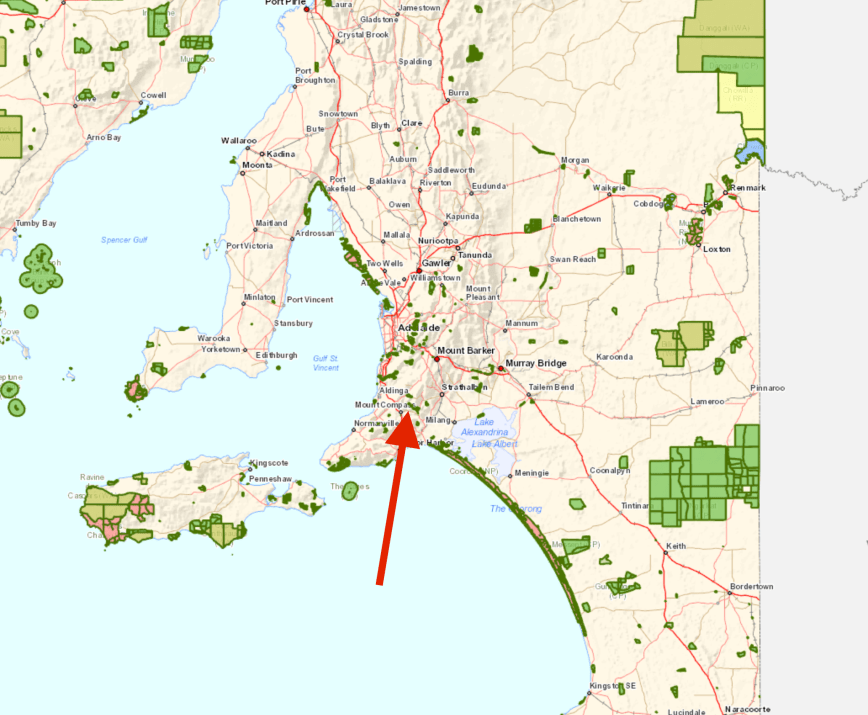
I had worked on New Years Eve, and didn’t finish work until 3.30 a.m. (and into bed by 4.00 a.m.) so I didn’t plan on going far on New Years Day.  The closest summit to me is Mount Lofty, just 15km down the road, but that had already been taken by 2 other VK5 activators, so I decided to activate Mount Gawler, VK5/ SE-013.  Although I had activated Mount Gawler during 2017, I would still pick up the points for 2018.

Mount Gawler is located about 35 km nort east of the city of Adelaide, and about 39 km north from my home.

Screen Shot 2018-01-02 at 10.28.20 am.png

Above:- Map showing the location of Mount Gawler.  Map courtesy of Open Street Map.

Mount Gawler is located in the Mount Lofty Ranges ‘Adelaide Hills’.  The Mount Lofty Ranges stretch from the southernmost point of the Fleurieu Peninsula at Cape Jervis northwards for over 300 kilometres (190 mi) before petering out north of Peterborough.  The part of the ranges nearest Adelaide is also called the Adelaide Hills.

Screen Shot 2018-01-02 at 10.19.25 am.png

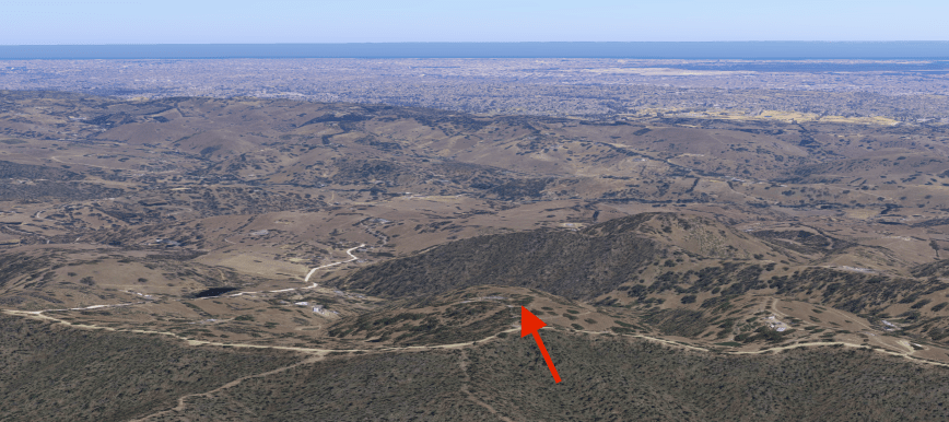
Above:- Aerial shot of Mount Gawler, with the city of Adelaide in the background.  Image courtesy of google maps

The summit is located after Lieutenant-Colonel George Gawler (1795-1869), the second Governor of South Australia.

George_Gawler2.jpg

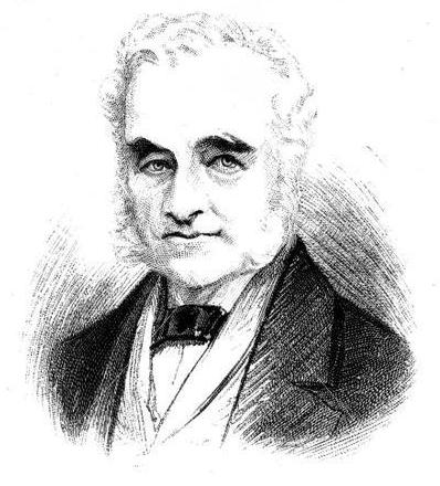
Above:- Lt-Col Gawler.  Image courtesy of wikipedia

Mount Gawler is 541 metres above sea level and is worth 2 points for the SOTA program.  It is easily accessible.  There is a trig point at the summit, but it is located on private property.  The landowners, Noel and Anne, are a very friendly couple and are happy for amateurs to access their property (with prior permision).  However, the activation zone includes the Mount Gawler Road, so you can operate from there.

Screen Shot 2018-01-02 at 10.30.16 am.png

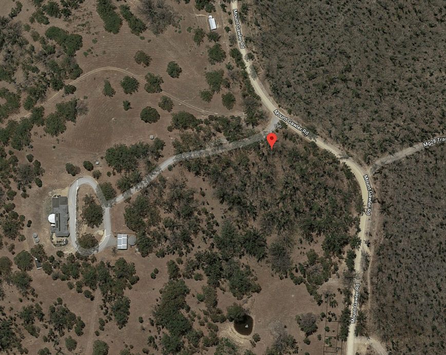
Above:- Aerial shot showing the summit.  Image courtesy of google maps

It is about a 40km from my home in the central Adelaide Hills to the summit.  The drive took me out through Nairne, Woodside, Lobethal, Gummeracha, and on to Kersbrook.   As I travelled down Checker Hill Road, the summit came into view.  The drive down Checker Hill Road towards Kersbrook is very steep, and this hill has featured in the world famous Tour Down Under Cycling event.  The Union Cycliste Internationale (UCI) categories Checker Hill as a category 2 climb (the second hardest).

DSC_0050

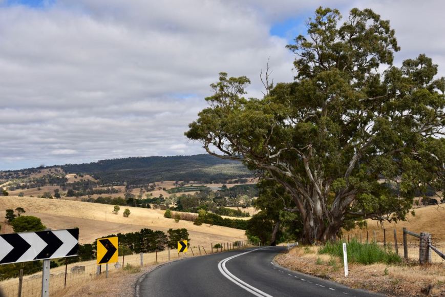
Above:- Looking down Checker Hill Road.

I then turned left onto Mount Gawler Road and soon reached the summit.  Noel and Anne had kindly unlocked the gate for me as I had telephoned them prior to my visit.

DSC_0065

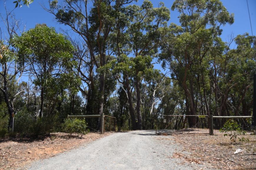
Above:- Entry to Noel and Anne’s property.

This area was ravaged by an extremely devastating bushfire back in early 2015, known as the Sampson Flat fire.  A total of 38 homes and 125 outbuildings were destroyed.  The total cost was estimated to be more than A$13 million.  Fortunately there was no loss of life, although a total of 134 injuries were reported.  The size of the area burnt was more than 12,500 hectares (31,000 acres).

Modis_4th.jpg

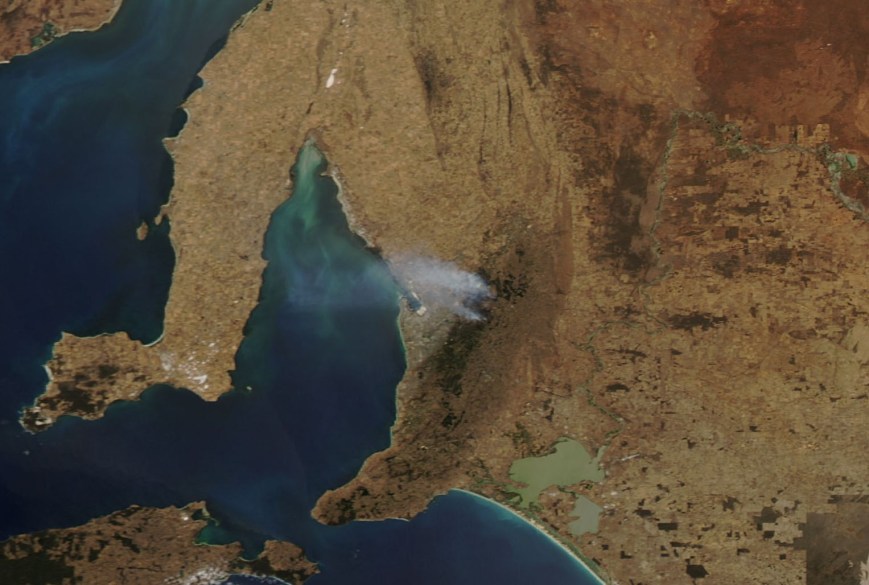
Above:- The Sampson Flat fire as seen from space.  Image c/o http://www.aerometrex.com.au/

The video below will give you a good idea on just how big this fire was and the devastation it caused.

There is a trig point at the summit, installed by the former Department of Lands.

There are also some fine views to be enjoyed of the northern and north eastern suburbs of Adelaide, and out north towards the Barossa Valley.  Gulf St Vincent is also clearly visible, and on a fine day you can see across to the Yorke Peninsula.

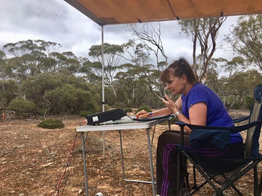
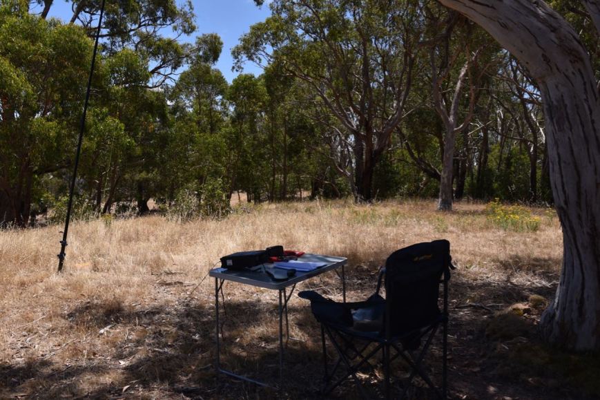
It was a beautiful sunny morning.  I setup underneath a gum tree alongside of the trig point.  As this is an easy drive up summit, I had the comfort and luxury of the fold up table and a deck chair.  For this activation I ran the Yaesu FY-897, at 20 watts, and the 20/40/80m linked dipole, and my 1/2 wave 15m dipole.  I supported the antennas on a 7 metre heavy duty squid pole.

I was set up and ready to go by just after 2330 UTC (10.00 a.m. local time).  I decided to leave the links out on the dipole, from my last activation, and try the 20m band first.  I normally use 40m first during my activations.  And I’m pleased I did try 20m first as there was a lot of activity there.  First in the log was Mick VK3PMG/VK3GGG, who was calling CQ on 14.310 and activating SOTA peak Blue Mountain VK3/ VS-015 which is located in the Landsborough Nature Conservation Reserve VKFF-2129.

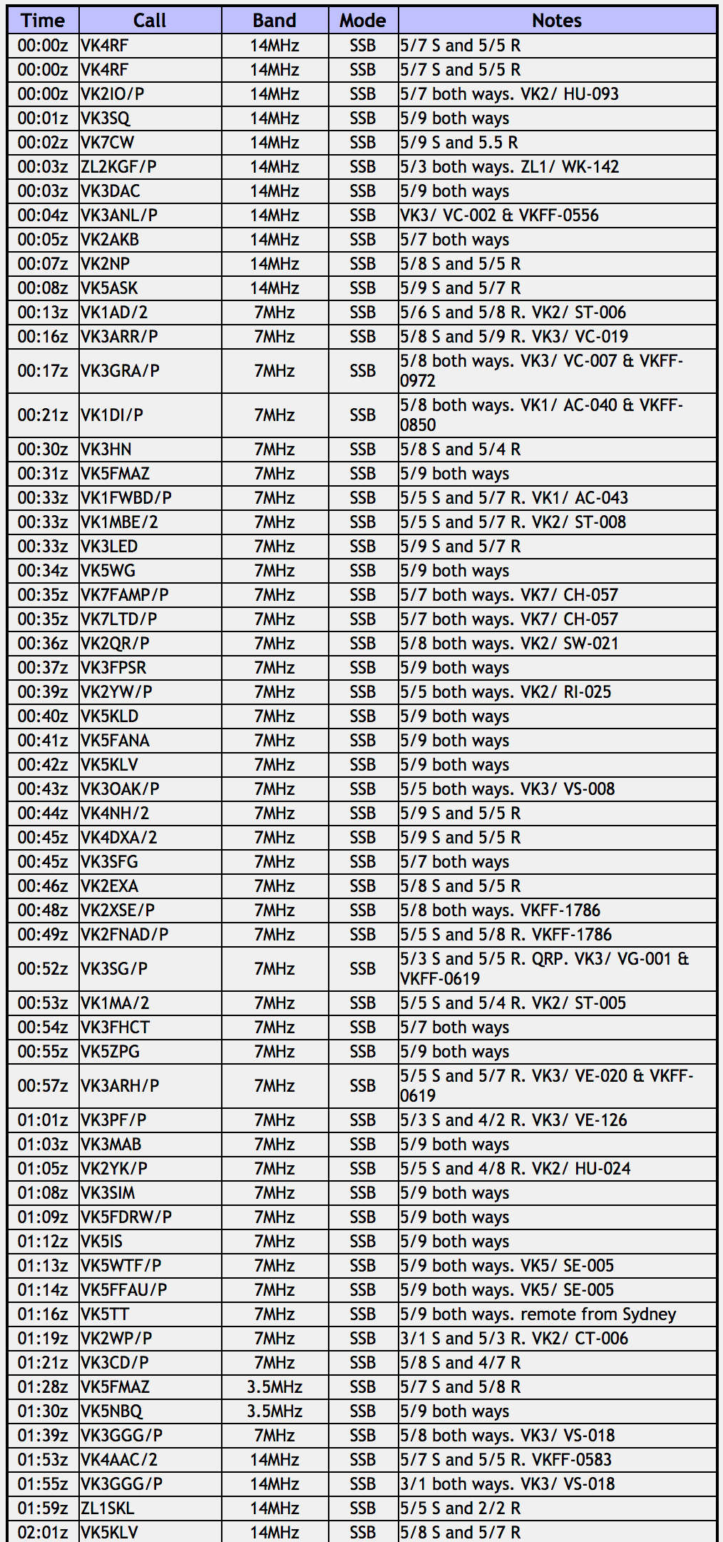
I then moved down to 14.305 and called CQ.  I logged 19 stations from VK2, VK3, VK5, VK6, VK7 and New Zealand before the UTC rollover.  This included 9 more Summit to Summit (S2S) contacts:-

  • John VK6NU, Mount Cooke VK6/ SW-031
  • Tony VK3CAT/p, Talbot Peak VK3/ VT-010
  • Marcus VK5WTF/p, Mount Lofty VK5/ SE-005
  • Ian VK5CZ/p, Black Bullock Hill VK5/ SE-016
  • Sam VK2GPL/p, Mount Canobolas VK2. CT-001
  • Kyle ZL2KGF/p, ZL1/ WK-142
  • Gerard VK2IO/p, Mount Elliot VK2/ HU-093
  • Nick VK3ANL/p, Mount Donna Buang VK3/ VC-002 & Yarra Ranges National Park VKFF-0556
  • Brian VK3MCD/4, Passage Peak VK4/ CW-242 (Hamilton Island)

Kyle ZL2KGF was a real bonus, a nice S2S into New Zealand.  Unfortunately he was the only New Zealand SOTA activator in the log during the morning.

After the UTC rollover I worked a further 11 stations from VK2, VK3, VK4, VK5, and New Zealand.  This included 3 more S2S contacts:-

  • Gerard VK2IO/p, Mount Eliot VK2/ HU-093
  • Kyle ZL2KGF/p, ZL1/ WK-142
  • Nick VK3ANL/p,Mount Donna Buang VK3/ VC-002 & Yarra Ranges National Park VKFF-0556

But callers soon dried up, so it was down with the squid pole, in with the links, and off to the 40m band.  First in the log there was Andrew VK1AD/2 on SOTA peak South Black Range VK2/ ST-006 who was calling CQ on 7.100, followed by Andrew VK3ARR/p on 7.100 activating Mount Warrenheip VK3/ VC-019.  I then worked Graeme VK3GRA/p who was activating Mount Macedon VK3/ VC-007 in the Macedon Regional Park VKFF-0972.  I kept tuning across the band and then found Ian VK1DI/p on Mount Ainslie VK1/ AC-040 in the Mount Ainslee Nature Reserve VKFF-0850.

As I was finishing my QSO with Ian, Noel drove down the driveway and I took some time out to have a chat.

I then propped on 7.130 and called CQ.  I logged 26 stations including the following S2S contacts:-

  • Wade VK1FWBD/p, Mount Stromlo VK1/ AC-043
  • Andrew VK1MBE/2, Baldy Range VK2/ ST-008
  • Angela VK7FAMP/p, Mount Dromedary VK7/ CH-057
  • Tony VK7LTD/p, Mount Dromedary VK7/ CH-057
  • Rob VK2QR/p, Pilot Reef Mountain VK2/ SW-021
  • John VK2YW/p, Mount Flakney VK2/ RI-025
  • Malcolm VK3OAK/p, Mount Cole VK3/ VS-008
  • Leigh VK3SG, Mount Cope VK3/ VG-001, in the Alpine National Park VKFF-0619
  • Matt VK1MA/2, Webbs Ridge VK2/ ST-005
  • Allen VK3ARH/p, Mount Lovick VK3/ VE-020 in the Alpine National Park VKFF-0619

I also spoke with Liz VK2XSE/p and her son Adrian who were activating the Murrumbidgee Valley Regional Park VKFF-1786.

When things slowed down I tuned across the band and found Peter VK3PF/p calling CQ from Mount Stanley VK3/ VE-126.  But Peter was the only new SOTA and/or Park activator that I could find, so I headed down to 7.090 and called CQ once again.  I logged 10 stations including

  • Adam VK2YK/p, VK2/ HU-024
  • Marcus VK5WTF/p, Mount Lofty VK5/ SE-005
  • Dave VK5FFAU/p, Mount Lofty VK5/ SE-005
  • Mike VK2WP/p, Bonfire Hill VK2/ CT-006

Surprisingly there was little activity on 40m, so I decided to give the 80m band a go.  I called CQ on 3.610 and self spotted on SOTAWatch and logged Marija VK5FMAZ and Brian VK5NBQ who was at nearby Lobethal with a huge signal.  But sadly they were my only 2 callers on 80m.

I saw a spot come up for Mick VK3GGG/p on Point 756 Pyrenees VK3/ VS-018 on 7.090, so it was down with the squid pole again and out with the 80m links.  After logging Mick I gave the 20m band a go, with my first contact there being with Rob VK4AAC/2 who was activating the Crawney Pass National Park VKFF-0583.  I then saw that Mick VK3GGG had moved from 40m to 14.315.  Mick was quite light, but we successfully made a contact (3/1 both ways), due to the low noise floors on both summits.

I then moved to 14.305 and called CQ which was answered by Soren ZL1SKL in Auckland in New Zealand.  I logged a further 8 stations, including Stuart VK8NSB up in Darwin, and also Matt VK1MA/2 activating Webbs Ridge VK2/ ST-005.

DSC_0057

I decided to give the 15m band a try and I am very pleased I did, as conditions there were quite good, with a total of 31 stations logged there from VK2, VK3, VK4, VK5, VK6, VK7, VK8, USA, and Japan.  I was very pleased to work Mike NW7E in Oregon in the USA who had a nice 5/7 signal.  And also JH1XMV in Japan.  Other good contacts on 15m included Stuart VK8NSB in Darwin, who was a little weaker on 15m compared to 20m.  Also Allen VK6XL in Western Australia.  Having activated portable in VK6 I know how hard it is over there on the other other side of Australia, so it’s always nice to log the Western Australian hams.

To finish off the activation I headed back to 40m where I spoke with Peter VK3TKK who was activating the Ironbark Road Nature Conservation Reserve VKFF-2113, and then Gordon VK5GY/p who was in the Ferries McDonald Conservation Park VKFF-0881.

Time to pack up and head home, with a total of 119 contacts in the log, including 34 Summit to Summit contacts and 12 parks.

I worked the following stations:-

Screen Shot 2018-01-02 at 10.16.47 am.png

Screen Shot 2018-01-02 at 10.09.29 am.png

Screen Shot 2018-01-02 at 10.09.42 am.png


References.

Wikipedia, 2018, <https://en.wikipedia.org/wiki/George_Gawler>, viewed 2nd January 2018

Wikipedia, 2018, <https://en.wikipedia.org/wiki/Coordinated_Universal_Time>, viewed 2nd January 2018

Wikipedia, 2018, <https://en.wikipedia.org/wiki/Mount_Lofty_Ranges>, viewed 2nd January 2018


Mount Magnificent Conservation Park 5CP-148 and VKFF-0916

Yesterday (Tuesday 26th December 2017) was Boxing Day, and a day of recovery here after a busy Christmas Day.  My wife’s mum had been staying with us for 2 days and in the afternoon Marija drove her down to the airport to fly back home.  As I had seen a few park activators spotted on parksnpeaks I decided to take the opportunity of heading out to activate the Mount Magnificent Conservation Park 5CP-148 & VKFF-0916.

CQ_CQ_Santa.jpg

I have activated and qualified the Mount Magnificent Conservation Park previously.  So this was another park to go towards my Boomerang Activator tally for World Wide Flora Fauna (WWFF).   I also dusted off my Buddipole and took that along with me, hoping to make some contacts on that antenna, after having it in storage for about 6 years.

The park is situated about 40 km south west of my home, and about 63 km south of Adelaide.

Screen Shot 2017-12-27 at 11.06.50 am.png

Above:- Map showing the location of the Mount Magnificent Conservation Park.  Map courtesy of Location SA Map Viewer.

To get to the park I travelled to Echunga and then on to Meadows.  I then took the Brookman Road towards Willunga, turning off at Connor Road, and then travelling south on Blackfellows Creek Road.

Screen Shot 2017-12-27 at 11.14.45 am.png

Above:- Aerial shot of the park.  Image courtesy of google maps

The park is located in close proximity to a number of other parks, including Kyeema, Finnis, Cox Scrub and Bullock Hill.

Screen Shot 2017-12-27 at 11.07.53 am

Above:- Map showing the location of the Mount Magnificent Conservation Park, in close proximity to a number of other parks.  Map courtesy of Location SA Map Viewer.

The Mount Magnificent Conservation Park is 90 hectares (222 acres) in size and was established on the 1st January 1967.  The park contains the Mount Magnificent summit which is 380 metres above sea level, but sadly does not qualify for the Summits on the Air (SOTA) program as it does not have the required prominence.  The summit does however reward those who climb to to the top, with some amazing views of the surrounding countryside.

I accessed the park via a track off Blackfellows Creek Road in the south western corner of the park.

DSC_0038

Above:- the track off Blackfellows Creek Road.

The track follows a fenceline and comes to an abrupt end.  However there is plenty of room here to set up.

Screen Shot 2017-12-27 at 11.23.02 am.png

Above:- Map showing my operating spot.  Map courtesy of google maps

I ran the Yaesu FT-897 at 40 watts for this activation.  I used one of the fenceposts to secure my 7 m telescopic squid pole, with the help of a couple of octopus straps.  I initially used the 80/40/20m linked dipole.

DSC_0037

My first station in the log was a Park to Park contact with Mark VK4SMA/p who was in the Plunkett Conservation Park VKFF-1631.  Mark had a good 5/6 signal.  I then moved down the band and started calling CQ on 7.139.  His was answered by Peter Vk5ZPG at Quorn in the north of South Australia, followed by Ray VK4NH/2 and then Keith VK3FMKE.  The band conditions on 40m seemed to be quite good.

Contact number 9 was another Park to Park, this time with Gerard VK2IO/p in the Wamberal Lagoon Nature Reserve VKFF-2013.  I went on to work a total of 30 stations on 40m from VK1, VK2, VK3, VK4, and VK5.  This included Mark VK5QI who was mobile in the Mid North of South Australia with a very nice 5/8 signal, Peter VK3PF mobile, Larry VK5BWA using a remote station in Mount Gambier, and Glenn VK2VX/p who was operating portable in his back yard.  I also logged Matt VK1MA/2 who was operating portable in the Kosciuszko National Park VKFF-0269.

I then tuned across the band and soon had my 4th Park to Park contact in the log for this activation, with a QSO with Ian VK1DI/2 who was activating the Mimosa Rocks National Park VKFF-0317.

I then set up the Buddipole and after a lot of mucking around I eventually had the VSWR down fine for 40m.  I had not used the Buddipole in about 6 years, and I suspect it is easier to set up than what I experienced.  After setting up the Buddipole I called CQ on 7.139 which was answered by Kevin VK3VEK with a strong 5/9 signal from western Victoria.  This was followed by Kevin VK3HKK in Morwell, and then another Park to Park, this time with Peter VK3TKK/p who was activating the Lerderderg State Park VKFF-0763.

I then saw a spot for Adam VK2YK and moved back to the linked dipole.  I logged Adam who was activating the Worimi State Conservation Area VKFF-1399.  After speaking with Adam I headed up to 7.150 and started calling CQ.  Simon VK3ELH/p gave me a shout from the Greater Bendigo National Park VKFF-0623, using his home brew Bitx40 transceiver.  I logged 2 further stations, John VK3YW and then Ron VK3IO, before deciding to give the 80m band a go.  My wife Marija had arrived home from the airport and had sent me a text to advise that there was no reception of my signal on 40m back home.

I called CQ on 3.610 and found the VSWR was through the roof.  So after checking the BNC connection and lowering the squid pole a number of times to check the links, I eventually found that my spare crocodile clip at the end of the antenna had got caught up on the barbed wire on the fence.  Once removed the VSW immediately dropped.  I logged Marija VK5FMAZ, John VK5NJ in Mount Gambier, and then Mick VK3GGG/VK3PMG in western Victoria.

It was starting to get hot, and I had run out of shade.  It was now 32 deg C.  I decided to have one last quick tune across the 40m band, and fortunately found David VK3IL/p activating SOTA peak VK3/ VT-006 in the Baw Baw National Park VKFF-0020.

To complete the activation I moved up to the 20m band where I logged 6 stations on 14.310, from VK2, VK4, VK6 and VK7.

DSC_0034

Above:- Some interested onlookers, in the adjacent paddock

I worked the following stations on 40m SSB:-

  1. VK4SMA/p (Plunkett Conservation Park VKFF-131)
  2. VK5ZPG
  3. VK4NH/2
  4. VK4DXA/2
  5. Vk3FMKE
  6. VK3GGG
  7. VK3PMG
  8. VK3SQ
  9. VK2IO/p (Wamberal Lagoon Nature Reserve VKFF-2013)
  10. VK1FWBD
  11. VK2YK
  12. VK3ZPF
  13. VK2EXA
  14. VK2PKT
  15. VK5KKT
  16. VK2HHA
  17. VK3KMH
  18. VK4RF
  19. VK4HA
  20. VK5QI/m
  21. VK3ARH
  22. VK5IS
  23. VK3PF/m
  24. VK5BWA
  25. Vk2VX/p
  26. VK2GPT/p
  27. VK1MA/p (Kosciuszko National Park VKFF-0269)
  28. VK2NEO
  29. VK2USH
  30. VK3CIB
  31. VK1DI/2 (Mimosa Rocks National Park VKFF-0317)
  32. VK3VEK
  33. VK3HKK
  34. VK3TKK/p (Lerderderg State Park VKFF-0763)
  35. VK2YK/p (Worimi State Conservation Area VKFF-1399)
  36. VK3ELH/p (Greater Bendigo National Park VKFF-0623)
  37. VK2YW
  38. VK3IO
  39. VK3IL/p (SOTA VK3/ VT-006 & Baw Baw National Park VKFF-0020)

I worked the following stations on 80m SSB:-

  1. VK5FMAZ
  2. VK5NJ
  3. VK3GGG
  4. VK3PMG

I worked the following stations on 20m SSB:-

  1. VK7JON
  2. VK2MKE
  3. VK4AAC/2
  4. VK4SYD
  5. VK6HRC
  6. VK4TJ

With 49 contacts in the log I packed up and headed home, taking a different route.  I travelled through the little town of Prospect Hill.  This area was originally called McHargs Hills by early European settlers, in honour of pioneers John and Elizabeth McHarg.  If you are ever in the area, the little Prospect Hill Museum is well worth a visit.

One of the interesting things to have a look at in Prospect Hill is the Flag Tree.  Flags were raised to signal the sighting of a ship carruing emigrants, mail or goods.  In this way, a message could be passed from tree to tree.  Various coloured flags were used to signal en emergency.  The site of Prospect Hill’s original flag tree is located alongside the museum.

This is very beautiful country through this part of the Mount Lofty Ranges.

DSC_0049

Above:- typical countryside in the Prospect Hill area

I continued along Milligans Road and then Morris Road and on to the town of Meadows, and then home.  It had been an enjoyable later afternoon out in the park, and proved that I need a lot more practice in setting up the Buddipole.


References.

Wikipedia, 2017, <https://en.wikipedia.org/wiki/Mount_Magnificent_Conservation_Park>, viewed 27th December 2017

VKFF Activator Honour Roll 200 certificate

Tonight I received my latest certificate for the World Wide Flora Fauna (WWFF) program.  It is the VKFF Activator Honour Roll 200 certificate, which is issued for having activated a total of 200 or more VKFF reference areas.

I would like to thank all of the hunters who have called me during my activations in VK1, VK2, VK3, VK5, VK6 and VK9.  I’ve had a lot of fun along the way and have seen some great spots around Australia.

VK5PAS VKFF Activator Honour Roll 200.png

WWFF Hunter 1044

Today I applied for and received my WWFF Hunter 1044 certificate.

It is issued for having worked 1,044 different WWFF reference areas.

Many thanks to all of the activators around the world and thankyou to Pit YO3JW, the WWFF Awards Manager.

H 1044 2017 VK5PAS 228.jpg

Our final activation for the VKFF Activation Weekend, the Ridley Conservation Park VKFF-0932

Our final activation for the 2017 VKFF Activation Weekend was the Ridley Conservation Park VKFF-0932, which is situated about 111 km north east of the city of Adelaide and about 26 km south west of the town of Swan Reach.

Screen Shot 2017-12-04 at 12.50.20 pm.png

Above:- Map showing the location of the Ridley Conservation Park north east of Adelaide.  Map courtesy of Location SA Map Viewer.

After leaving the Swan Reach Conservation we headed back east on the Stott Highway and then turned right onto Murraylands Road passing through the little locality of Langs Landing.  There are some nice spots to stop here to enjoy the great views of the Murray River.

We soon reached the northern section of the park.  Whilst travelling along the Murraylands Road we logged Les VK5KLV/p from the mobile.  Les was in the Whyalla Conservation Park VKFF-0808 on the Eyre Peninsula.  We turned down a dirt track at the intersection of Murraylands Road and Railway Sleeper Track.  Don’t try this if you are in a conventional vehicle.  The track is very narrow and is rocky.

The Ridley Conservation Park is a long and narrow park (10km by 0.4 km) and has a total area of around 414 hectares.  The southern boundary of the park lies on the edge of the valley of the River Marne, with the highest point in the park being located in this southern section.  The remainder of the park to the north comprises flat country which is typical of the limestone plaines west of the Murray River.  The park covers a transition zone in the natural vegetation just to the south of Goyder’s Line between the mallee open scrub to the south and the semi-arid, low woodland to the north.

The park is covered by two major vegetation formations: 35 per cent comprises an open scrub of red mallee and stands of murray pine and associated areas of shrubland dominated by hop bush.  The remaining 65 per cent of the park comprises low open woodland of native apricot and false sandalwood.  The understorey consists of spear-grass and ephemeral herbs; wait-a-while  also occurs in this formation.  A small area near the southern boundary of the park and much of the northern part is almost devoid of trees and can be sub-categorised as open grassland.

The park was originally set aside to conserve native vegetation and bird habitats, but in addition, the open areas of the park include a number of warrens of the Southern Hairy-nosed Wombat.  Other native animals found in the park include echidna and Western Grey kangaroos.  Various birdlife can be found in the park including Mallee Ringnecks, Purple-crowned Lorikeets, Regent Parrot, White-winged Fairywren, and Butcherbirds.  A total of 109 species of bird have been recorded in the park.

Southern_Hairy-nosed_Wombat.jpg

Above:- the Southern Hairy-nosed Wombat.  Image courtesy of wikipedia.

Ridley was once part of a Travelling Stock Reserve (TSR) which ran for roughly 5-10 kilometres parallel to the River Murray.  This reserve linked the stock market of Burra to the north with Murray Bridge to the south.  In the early days of the colony of South Australia, sheep and cattle were driven overland from New South Wales to stock the newly-developed pastoral industry in South Australia.  During the early 1860’s when the Hundreds of land were proclaimed on the western plains of the Murray River, it became necessary to provide areas under the Crown for the localised movement of stock and to give access to markets.  Travelling Stock Reserves, which normally consisted of 20-chain (approx 400 metres) width, were given fixed boundaries and often followed existing stock tracks.

screen-shot-2016-11-24-at-8-17-02-pm.jpg

This particular stock route, as with others, became uncessary with the advent of mechanised transport such as the railway.  The Morgan to Adelaide railway was completed in 1878.  Increasingly there were moves to resume and allot the TSRs to adjoining landowners.

By 1901 local landowners in the Ridley area had approached the Department of Lands, requesting that the TSR in the Hundreds of Ridley and Fisher be resumed and made open for allotment.  During 1901 and again in 1907, proposals went before Parliament, but were not approved.  In 1910 farmers adjoining the reserve requested permission to erect fences and graze sheep on the TSR, claiming that the unused TSR harboured vermin and tied up valuable grazing land.

By 1934 the District Council of Caurnamont had contacted the Director of Lands requesting that the TSR be resumed for allotment, again claiming that it was a home for vermin and was a drain on council funds.  Similar requests were made again in 1937.  In 1939, the ranger of the Crown Lands Department, Inspector Klau inspected the TSR and reported that it was used for camping and watering stock when feed was scarce in the districts to the north of the TSR.  He recommended that the TSR not be resumed as he believed the reserve would be used for this purpose again in the future.

During 1838-1940 there were a number of requests to cut wood in the reserve for charcoal burning and a proposal to clear 28 hectares of the reserve north of Haywards Hill.  The ranger described the reserve as ‘an asset to the State’ and recommended the TSR be retained in its uncleared state.

By 1956 there were further requests to utilise the TSR and on this occsion Annual Licences were granted for grazing purposes.

In 1966 when land was being resumed and purchased for the purpose of national parks, the Land Board proposed that portions of the TSR “be retained and dedicated as a Wildlife Reserve under the control of the Commissioners of the National Parks and Wildlife Reserves at the expiration of the current Annual Licence”.  In September 1967, a field officer for the National Parks Commission, Mr. G.C. Cornwall inspected the TSR and stated “Although a long narrow strip of land such as this is not the ideal shape for a national park, the idea of preserving natural vegetation and bird habitats by setting aside portions of the Travelling Stock Reserve is an excellent one and the area under investigation is suitable for this purpose‘.

First proclaimed as Ridley National Parks Reserve on 30 May 1968 and re-proclaimed on 27 April 1972 as Ridley Conservation Park.

Screen Shot 2017-12-04 at 12.51.32 pm.png

Unfortunately I didn’t look down when setting up the awning/annexe on the Toyota Hi Lux.  We had set up just 3 metres away from a number of ants nests.  Fortunately they kept their distance and didn’t cause us any dramas during the activation.

DSC_2001

After setting up we immediately went to 7.150 and logged Les VK5KLV/p, Park to Park, from the Whyalla Conservation Park VKFF-0808 in the ‘Iron Triangle’ region of South Australia.  Marija then headed down to 7.130 and called CQ, which was answered by Mick VK3GGG/VK3PMG, followed by Neil VK4HNS/p in the Girraween National Park VKFF-0198.

The static crashes were terrible, strength 9 plus at times and it made operating very difficult.  Under some very trying conditions, Marija logged a total of 24 stations before deciding that the static crashes were just too annoying.  Included in these contacts were a number of further Park to Park contacts as follows…..

  • Mark VK4SMA/p in the Crows Nest National Park VKFF-0121
  • Dave VK2ZK/p in the Yellomundee Regional Park VKFF-0558
  • Dave VK2JDC/p in the Yellomundee Regional Park VKFF-0558
  • Rob VK4AAC/p in the Clear Mountain Conservation Park VKFF-1511
  • VK2IO/p in the Pitt Town Nature Reserve VKFF-1984

I then put out some calls on 7.130 and despite the very severe static crashes, was able to log 19 stations from VK1, VK3, VK3, VK4, and VK7.  Marija and I then lowered the squid pole and inserted the 80m links and headed to 3.610.  I logged 5 stations on 80m, the first being Mick VK3GGG/VK3PMG, followed by John VK5BJE, Adrian VK5FANA, and finally Adrian VK5FANA.

Whilst on 80m Marija received a call from Greg VK8GM, who was part of the VK8ZKZ team in a park in the Northern Territory.  He advised that they were on 15m, so Marija and I quickly put up the 15m 1/2 wave, but sadly could not hear a peep from Greg and his team.  I called CQ on 21.244 and logged Tadashi JA1VRY in Japan.

Greg phoned back to ask if we could try 20m.  So it was off to 20m, but again we could not hear Greg.  We could hear the VK2 and VK6 hunters.  Also at this time we saw Allen VK3ARH/p spotted on parksnpeaks on 40m in a park.  So rather than taking down the 15m dipole, we worked Allen from the vehicle.  He was a good 5/7 from the Mount Mercer Nature Conservation Reserve VKFF-2154.

Down came the linked dipole again, and back with the 15m dipole.  I logged just one more station on 15m, that being Nigel VK6NI, who although quite weak, was very workable from Ridley. I then re-erected the 20/40/80m linked dipole and headed to 14.310, where I found Phil VK6ADF/p in the Coalseam Conservation Park VKFF-1418.  I logged Phil, Park to Park, and then headed up the band to 14.315 where I logged 6 stations from VK4, VK6, VK7 and Japan.

To wrap up the activation I went back to 7.144 on 40m where I logged 13 stations from VK1, VK2, VK3, VK4, VK6, and VK7, including a Park to Park with Nik VK3NLK/p who was in the Langwarrin Flora & Fauna Reserve VKFF-2031.

DSC_2007

It was time to call it a day and head home after a very enjoyable 2017 VKFF Activation Weekend.  From Ridley, Marija had 25 contacts in the log, including 9 Park to Park contacts, whilst I had 54 QSOs in the log, including

Marija worked the following stations on 40m SSB:-

  1. VK5KLV/p (Whyalla Conservation Park VKFF-0808)
  2. VK3GGG
  3. VK3PMG
  4. VK4HNS/p (Girraween National Park VKFF-0198)
  5. VK3KIX
  6. VK3PF
  7. VK2HHA
  8. VK2TCL
  9. VK7JON
  10. VK3MDH/m
  11. VK3UH
  12. VK2XXM
  13. VK4SMA/p (Crows Nest National Park VKFF-0121)
  14. VK2ZK/p (Yellomundee Regional Park VKFF-0558)
  15. VK2JDC/p (Yellomundee Regional Park VKFF-0558)
  16. VK4AAC/p (Clear Mountain Conservation Park VKFF-1511)
  17. VK3ANL
  18. VK2IO/p (Pitt Town Nature Reserve VKFF-1984)
  19. VK3KMH
  20. VK2PKT
  21. VK2YK
  22. VK2YW
  23. VK2FOUZ
  24. VK4TJ
  25. VK3ARH/p (Mount Mercer Nature Conservation Reserve VKFF-2154)
  26. VK3NLK/p (Langwarrin Flora & Fauna Reserve VKFF-2031)

I worked the following stations on 40m SSB:-

  1. VK5KLV/p (Whyalla Conservation Park VKFF-0808)
  2. VK4HNS/p (Girraween National Park VKFF-0198)
  3. VK4SMA/p (Crows Nest National Park VKFF-0121)
  4. VK2ZK/p (Yellomundee Regional Park VKFF-0558)
  5. VK2JDC/p (Yellomundee Regional Park VKFF-0558)
  6. VK4AAC/p (Clear Mountain Conservation Park VKFF-1511)
  7. VK2IO/p (Pitt Town Nature Reserve VKFF-1984)
  8. VK3GGG
  9. VK3PMG
  10. VK3PF
  11. VK3KAI
  12. VK3CRG
  13. VK4NH
  14. VK4DXA
  15. VK3FSMT
  16. VK3UH
  17. VK7QP
  18. VK2FOUZ
  19. VK2SK
  20. VK2XXM
  21. VK3KMH
  22. VK3MNZ
  23. VK1DI
  24. VK3FHCT
  25. VK4RF
  26. VK4HA
  27. VK3ARH/p (Mount Mercer Nature Conservation Reserve VKFF-2154)
  28. VK6YV
  29. VK3NLK/p (Langwarrin Flora & Fauna Reserve VKFF-2031)
  30. VK3BBB
  31. VK1LAJ
  32. VK4FDJL
  33. VK3VGB
  34. VK7JON
  35. VK2AR
  36. VK3FMKE
  37. VK5NJ
  38. VK3ZPF
  39. VK7FRJG
  40. VK3RW

I worked the following stations on 80m SSB:-

  1. VK3PMG
  2. VK3GGG
  3. VK5BJE
  4. VK5FANA
  5. VK5SFA

I worked the following stations on 15m SSB:-

  1. JA1VRY
  2. VK6NI

I worked the following stations on 20m SSB:-

  1. VK6ADF/p (Coalseam Conservation Park VKFF-1418)
  2. VK4GSF
  3. VK4RF
  4. VK4HA
  5. VK6YV
  6. VK7JON
  7. JM4WUZ

After packing up Marija and I headed to Shell Hill, just off the Black Hill Road.  Shell Hill is so named due to the deposit of oyster shells which is believed to be about 5 million years old.  It is the only one of its kind above the surface of the earth in the Southern hemisphere.  It is quite a sight.

We continued along the Black Hill Road until we reached the little town of Black Hill which is located on the banks of the Marne River.  Until 1918, when many places in South Australia had their names changed due to anti German sentiment in World War One, the town was known as Friedensthal, meaning ‘Valley of Peace’.  In its day there was quite a community here, including a post office, school and shop.  But today all that remains are some farmhouses, the old church, and the hall.

We continued on to the Ridley Road and eventually home.  It was a relatively slow drive as there were many kangaroos out on the road.


References.

Birds SA, 2016, <http://www.birdssa.asn.au/location/ridley-conservation-park/&gt;, viewed

Discover Murray, 2017, <http://www.murrayriver.com.au/swan-reach/shell-hill/>, viewed 4th December 2017

National Parks and WIldlife Service, 1984, ‘Conservation Parks of the Murraylands (Western Plains) Management Plans

Wikipedia, 2017, <https://en.wikipedia.org/wiki/Black_Hill,_South_Australia>, viewed 4th December 2017

Swan Reach Conservation Park VKFF-0832

Day two (Sunday 26th November 2017) of the 2017 VKFF Activation Weekend had arrived.  Marija and I had enjoyed 2 great nights in Morgan and it was time for us to move on to our first park activation of Sunday, the Swan Reach Conservation Park VKFF-0832 which is located about 170 km north east of Adelaide and about 12 km west of the town of Swan Reach.

Screen Shot 2017-12-04 at 10.59.39 am.png

Above:- Map showing the location of the Swan Reach Conservation Park.  Map courtesy of Location SA Map Viewer.

After breakfast we headed down to the ferry at Morgan, which crossed the Murray River.  There are a couple of ways of getting to Swan Reach from Morgan, but this is the way the GPS decided to take us.  On the way to the ferry I spoke from the mobile with Liz VK2XSE/p on 7.144.  Liz was activating the Balowra State Conservation Area VKFF-1269 in New South Wales.

Whilst waiting for the ferry, and then whilst on borad the ferry crossing the river, Marija and I worked Mick VK3PMG/p on 7.160, who was in the Jallukar Nature Conservation Reserve VKFF-2115.  Mick had a good 5/7 signal into the mobile, and gave us a 5/7 in return.

We travelled south on the Murbko Road which runs alongside the mighty Murray River.  There are a number of spots here where you can stop to enjoy some spectacular views of the Murray River, which is exactly what we did.

We then reached the Sturt Highway and headed towards the town of Blanchetown, before turning left on to Hunter Road which again hugged the Murray River to our right.  The town of Swan Reach was our next stop.  Swan Reach was initially settled way back in the 1850’s and was originally the largest of five sheep and cattle stations in the area.  It subsequently became a busy riverboat port in South Australia.  We waited to board the ferry at Swan Reach, whilst having a look at the flood levels on an electricity pole.  The 1956 flood literally wiped out the town of Swan Reach.

DSC_1968

After crossing the Murray, we travelled west on the Swan Reach-Angaston Road (the Stott Highway), and soon reached the park.  The Swan Reach Conservation Park is 2,017 hectares in size, with the majority of the park being an open area of Mallee Box, red mallee, and yorrell.  The remaining area consists of low woodland with false sandalwood and bullock bush over an understorey of spear-grass and ephemeral herbs.

DSC_1976

About 97 species of native bird have been recorded in the park including Chestnut-rumped Thornbill, Southern Whiteface, Spiny-cheeked Honeyeater, Grey Shrikethrush, Australian Magpie, Malleefowl, Little Eagle, Crested Pigeon, and Inland Thornbill.  Most of the mallee scrub in the park has been cut ver for firewood and the present vegetation is regowth.  The park lacks the numbers of large, mature mallees which originally occurred in the area and provided nesting hollows for birds.  I hardly saw a bird in the park during our visit.

Native animals found in the park include Western Grey kangaroos, Red Kangaroos, and the Southern Hairy-nosed wombat.  Gould’s Goanna and Central Beared Dragons can be found in the park.

Marija and I turned on to the Old Punyelroo Road and then on to a dirt track leading into the park.

Screen Shot 2017-12-04 at 11.35.47 am.png

Above:- Aerial shot showing our operating spot in the park.  Image courtesy of google maps

There was plenty of room here to pull the Toyota Hi Lux off the track and roll out the awning/annexe, and stretch out the 20/40/80m linked dipole.

As we drove in to the park we worked Marc VK3OHM/p who was activating the Warrandyte State Park VKFF-0774.  As we were within the boundaries of the park it qualified as a Park to Park contact, as mobile is allowed in the WWFF program.  Marc had a cracking 5/9 signal into the mobile.

We set up and immediately headed to 7.140 to get another Park to Park with Marc VK3OHM/p as we were now set up portable.  After logging Marc, we headed up to 7.150 and Marija started calling CQ, whilst I spotted her on parksnpeaks.  Marija’s CQ call was answered by Tom VK5NFT at Millicent in the South East, followed by Tom VK5AA also in the South East at Mount Gambier, and then Chris VK3FHCT.

Our second Park to Park was to follow, a contact with Mick VK3GGG/VK3PMG who was activating the Jallukar Nature Conservation Reserve VKFF-2115.  Marija soon had her 10th contact in the log, a QSO with John VK4/AC8WN.  Marija then logged John under another one of his calls VK4/VE6XT and then our good friend John VK5BJE.

As it was a little quiet, we took the opportunity of tuning across the 40m band   to see if we could find some more park activators.  We soon found Gerard VK2IO/p who was activating the Pitt Town Nature Reserve VKFF-1984.

Marija then went back to 7.150 and called CQ, logging a total of 15 stations including the following three more Park to Park contacts….

  • Rob VK4AAC/p in the Clear Mountain Conservation Park VKFF- 1511
  • Rob VK4FFAB/p in the Clear Mountain Conservation Park VKFF- 1511
  • Gerard VK2JNG/p in the Koreelah National Park VKFF-0268

Marija now had 28 contacts in the log and the calls on 40m had slowed down a little, so we decided to go have a listen on the 80m band.  Marija called CQ on 3.610 which was answered by John VK5BJE, followed by Adrian VK5FANA, Tony VK5MRT, and then Ivan VK5HS mobile, all of whom had great signals on 80m.  We also made a Park to Park contact with Mick VK3GGG/VK3PMG who was now activating the Illawarra Nature Conservation Reserve VKFF-2111.  Mick had a good 5/5 signal.

We headed back to 40m where we logged the following Park to Park contacts…..

  • Ian VK1DI/p in the Crace Grassland Nature Reserve VKFF-0838
  • Nick VK6FSEA/p in the Leschenault Peninsula Conservation Park VKFF-1430

We returned to 7.150 and Marija continued to call CQ, logging a further 6 stations from VK2, VK3, VK4 and VK7.  Unfortunately we had a couple of VK6 stations come up on the frequency, and despite us hearing them well, they were unable to hear either Marija or I.  It just wasn’t worth competing with them, so we left the frequency.  We found Mick VK3PMG/VK3GGG on 7.155  in the Illawarra Nature Conservation Reserve VKFF-2111.  This was Marija’s 44th contact.  She had qualified the park for the global WWFF program.

IMG_0861

Marija then took a coffee break, whilst I put out a few CQ calls on 7.144 on 40m logging 16 stations from VK1, VK2, VK3, VK4, VK5, and VK7, including a Park to Park with Neil VK4HNS/p who was in the Girraween National Park VKFF-0198.

Marija and I then headed up to 21.244 on the 15m band, hoping to get a few contacts.  And we were pleased that we put up the 15m /12 wave dipole as the band was wide open to New South Wales, Queensland and Western Australia.  Our first contact on 15m was a Park to Park with Gerard VK2JNG/p who was in the Koreelah National Park VKFF-0268.  Other Park to Park contacts on 15m were made with Neil VK4HNS/p in the Giraween National Park VKFF-0198, and Rob VK4AAC/p who was activating the Clear Mountain Conservation Park VKFF-1511.

So with a number of contacts in the log on 15m, it was time to try the 20m band.  I logged 10 contacts there including the following Park to Park contacts…..

  • Neil VK4HNS/p in the Giraween National Park VKFF-0198
  • Gerard VK2IO/p in thePitt Town Nature Reserve VKFF-1984
  • Gerard VK2JNG/p in the Koreelah National Park VKFF-0268

We were about to pack up when we noticed a spot for Les VK5KLV/p on 7.150 in the Whyalla Conservation Park VKFF-0808.  So it was off to 40m again to log Les Park to Park.

Marija had 53 QSOs in the log including 18 Park to Park contacts.  I had 49 QSOs in the log including 22 Park to Park contacts.  Between us we had made 102 QSOs, including 40 Park to Park contacts.

Marija worked the following stations on 40m SSB:-

  1. VK3OHM/p (Warrandyte State Park VKFF-0774)
  2. VK5NFT
  3. VK5AA
  4. VK3FHCT
  5. VK3PMG/p (Jallukar Nature Conservation Reserve VKFF-2115)
  6. VK3GGG/p (Jallukar Nature Conservation Reserve VKFF-2115)
  7. VK2PKT
  8. VK3MRH
  9. VK2XXM
  10. VK4TJ
  11. VK4/AC8WN
  12. VK4/VE6XT
  13. VK5BJE
  14. VK2IO/p (Pitt Town Nature Reserve VKFF-1984)
  15. VK3PF
  16. VK3KAI
  17. VK3GV
  18. VK3SQ
  19. VK3UH
  20. VK3FRAB
  21. VK3ANL
  22. VK4AAC/p (Clear Mountain Conservation Park VKFF- 1511)
  23. VK4FFAB/p (Clear Mountain Conservation Park VKFF- 1511)
  24. VK2JNG/p (Koreelah National Park VKFF-0268)
  25. VK4RF
  26. VK4HA
  27. VK3ARH
  28. VK3ZVX
  29. VK3FLJD
  30. Ian VK1DI/p (Crace Grassland Nature Reserve VKFF-0838)
  31. Nick VK6FSEA/p (Leschenault Peninsula Conservation Park VKFF-1430)
  32. VK4NH
  33. VK4DXA
  34. VK3ELH
  35. VK7FRJG
  36. VK4PDX
  37. VK2VW
  38. Mick VK3PMG/p (Illawarra Nature Conservation Reserve VKFF-2111)
  39. Mick VK3GGG/p (Illawarra Nature Conservation Reserve VKFF-2111)
  40. VK4HNS/p (Girraween National Park VKFF-0198)
  41. VK5KLV/p (Whyalla Conservation Park VKFF-0808)

Marija worked the following stations on 80m SSB:-

  1. VK5BJE
  2. VK5FANA
  3. VK5MRT
  4. VK5HS/m
  5. VK3PMG/p (Illawarra Nature Conservation Reserve VKFF-2111)
  6. VK3GGG (Illawarra Nature Conservation Reserve VKFF-2111)

Marija worked the following stations on 15m SSB:-

  1. VK2JNG/p (Koreelah National Park VKFF-0268)
  2. VK4HNS/p (Giraween National Park VKFF-0198)
  3. VK4AAC/p (Clear Mountain Conservation Park VKFF-1511)
  4. VK4RF
  5. VK4HA
  6. VK2YK

I worked the following stations on 40m SSB:-

  1. VK3OHM/p (Warrandyte State Park VKFF-0774)
  2. VK3PMG/p (Jallukar Nature Conservation Reserve VKFF-2115)
  3. VK3GGG/p (Jallukar Nature Conservation Reserve VKFF-2115)
  4. VK2IO/p (Pitt Town Nature Reserve VKFF-1984)
  5. VK4AAC/p (Clear Mountain Conservation Park VKFF- 1511)
  6. VK4FFAB/p (Clear Mountain Conservation Park VKFF- 1511)
  7. VK2JNG/p (Koreelah National Park VKFF-0268)
  8. Ian VK1DI/p (Crace Grassland Nature Reserve VKFF-0838)
  9. Nick VK6FSEA/p (Leschenault Peninsula Conservation Park VKFF-1430)
  10. Mick VK3PMG/p (Illawarra Nature Conservation Reserve VKFF-2111)
  11. Mick VK3GGG/p (Illawarra Nature Conservation Reserve VKFF-2111)
  12. VK2YW
  13. VK7JON
  14. VK3FLJD
  15. VK3ELH
  16. VK4HNS/p (Giraween National Park VKFF-0198)
  17. VK4FDJL
  18. VK1CT
  19. VK3UH
  20. VK5FMWW
  21. VK2YK
  22. VK3MB
  23. VK5TR
  24. VK3PF
  25. VK5XD
  26. VK3MIJ
  27. VK5BJE
  28. VK5KLV/p (Whyalla Conservation Park VKFF-0808)

I worked the following stations on 80m SSB:-

  1. Mick VK3PMG/p (Illawarra Nature Conservation Reserve VKFF-2111)
  2. Mick VK3GGG/p (Illawarra Nature Conservation Reserve VKFF-2111)

I worked the following stations on 15m SSB:-

  1. VK2JNG/p (Koreelah National Park VKFF-0268)
  2. VK2FSAV
  3. VK2YK
  4. VK4HNS/p (Giraween National Park VKFF-0198)
  5. VK2XXM
  6. VK4AAC/p (Clear Mountain Conservation Park VKFF-1511)
  7. VK6XN
  8. VK4RF
  9. VK4HA

I worked the following stations on 20m SSB:-

  1. VK4HNS/p (Giraween National Park VKFF-0198)
  2. VK2UH
  3. VK6NI
  4. VK2IO/p (Pitt Town Nature Reserve VKFF-1984)
  5. VK4PDX
  6. VK2YK
  7. VK4DA
  8. VK2JNG/p (Koreelah National Park VKFF-0268)
  9. VK6ADF/m
  10. VK4SMA/p (Crows Nest National Park VKFF-0121)


References.

Birds SA, 2017, <https://birdssa.asn.au/location/swan-reach-conservation-park/>, viewed 4th December 2017

Wikipedia, 2017, <https://en.wikipedia.org/wiki/Swan_Reach,_South_Australia>, viewed 4th Dceember 2017