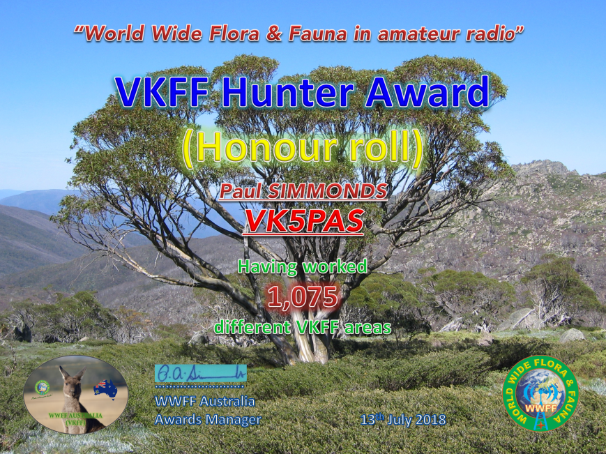
Tonight I qualified for my latest certificate in the VKFF program. It is the VKFF Hunter Honour Roll 1,075 certificate, issued for having worked 1,075 different VKFF reference areas.
Many thanks to all of the activators who made this possible.

Tonight I qualified for my latest certificate in the VKFF program. It is the VKFF Hunter Honour Roll 1,075 certificate, issued for having worked 1,075 different VKFF reference areas.
Many thanks to all of the activators who made this possible.
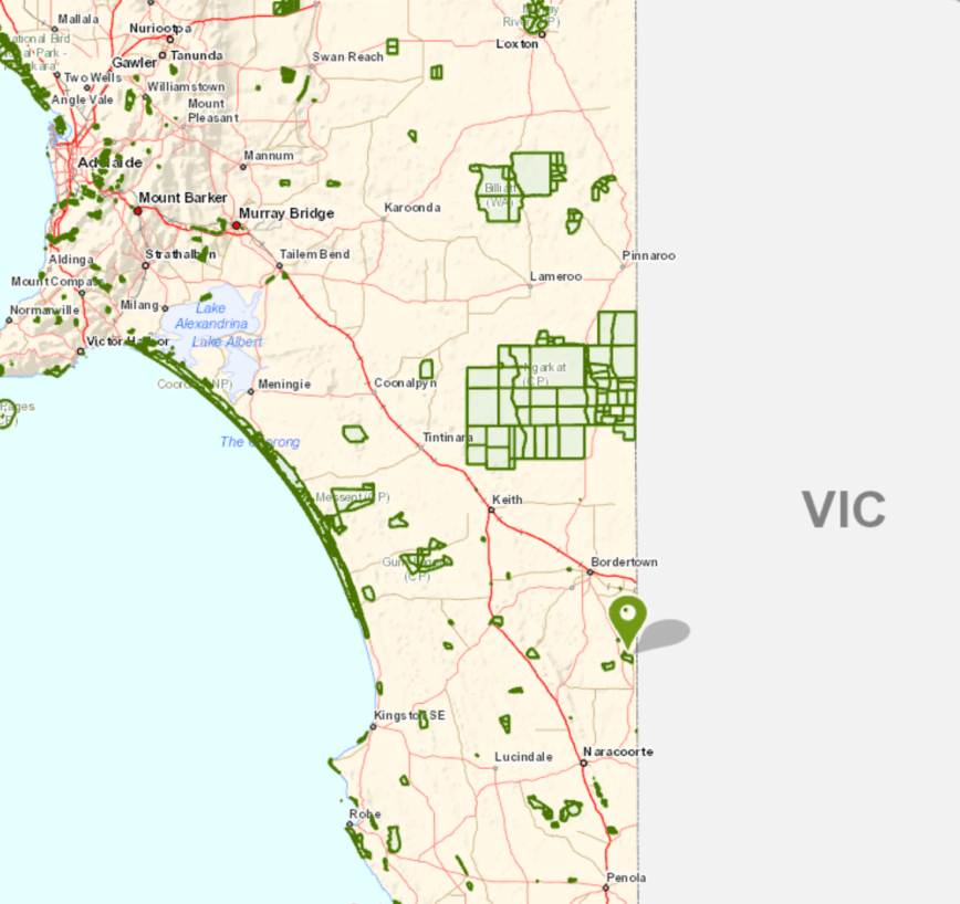
After leaving the Geegeela Conservation Park I decided to do a quick activation at the Poocher Swamp Game Reserve VKFF-1741. This would be my 5th park for the day, and another unique park for me as an activator.
Poocher Swamp is about 271 km south east of Adelaide, and about 8 km west of the town of Bordertown.
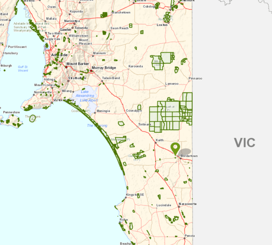
Above:- Map showing the location of the Poocher Swamp Game Reserve in the south east of South Australia. Map courtesy of Location SA Map Viewer.
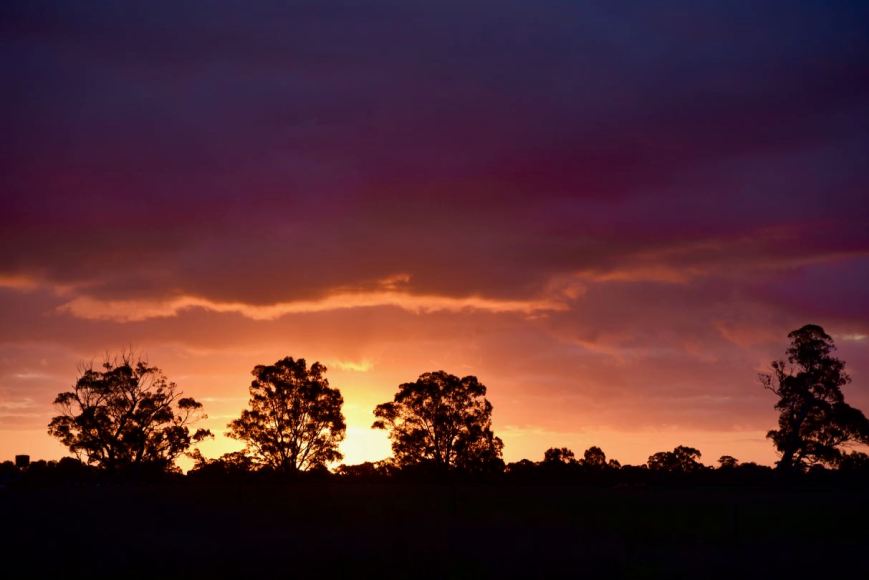
This was to be a quick activation, as it was now 5.30 p.m. and I had a 2 & 1/2 hour drive ahead of me. As I drove towards the park I enjoyed a magnificent sunset.
The Poocher Swamp Game Reserve is 77 hectares in size and was proclaimed on 14th November 1985, with additional land added on 16th March 1989. During the late 1950’s, a number of levee banks were constructed in the swamp to impound water and attract bird life.
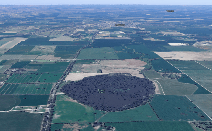
Above:- Aerial view of the Poocher Swamp Game Reserve. Image courtesy of google maps
Over many years, the impoundment of water has caused the inundation of the River Red Gums in the reserve, and as a result many have died. However regrowth is occurring at the upper limits of the floor waters and at the Tatiara Creek entrance to the swamp.


Birds SA have recorded a total of 85 bird species in the park including Grey Teal, Pacific Black Duck, Black-tailed Nativehen, Galah, Red-rumped Parrot, Australian Magpie, White-plumed Honeyeater, Magpielark, Australian Pelican, Royal Spoonbill, Purple-crowned Lorikeet, New Holland Honeyeater, and Rufous Songlark
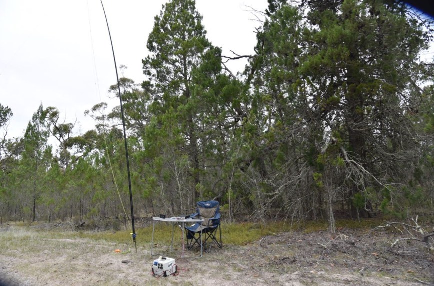
Unfortunately I was very short of time, so I only spent a few short minutes having a look at the park. I didn’t even get the time to walk down to the actual swamp in the reserve. I set up just inside the gate leading into the reserve.
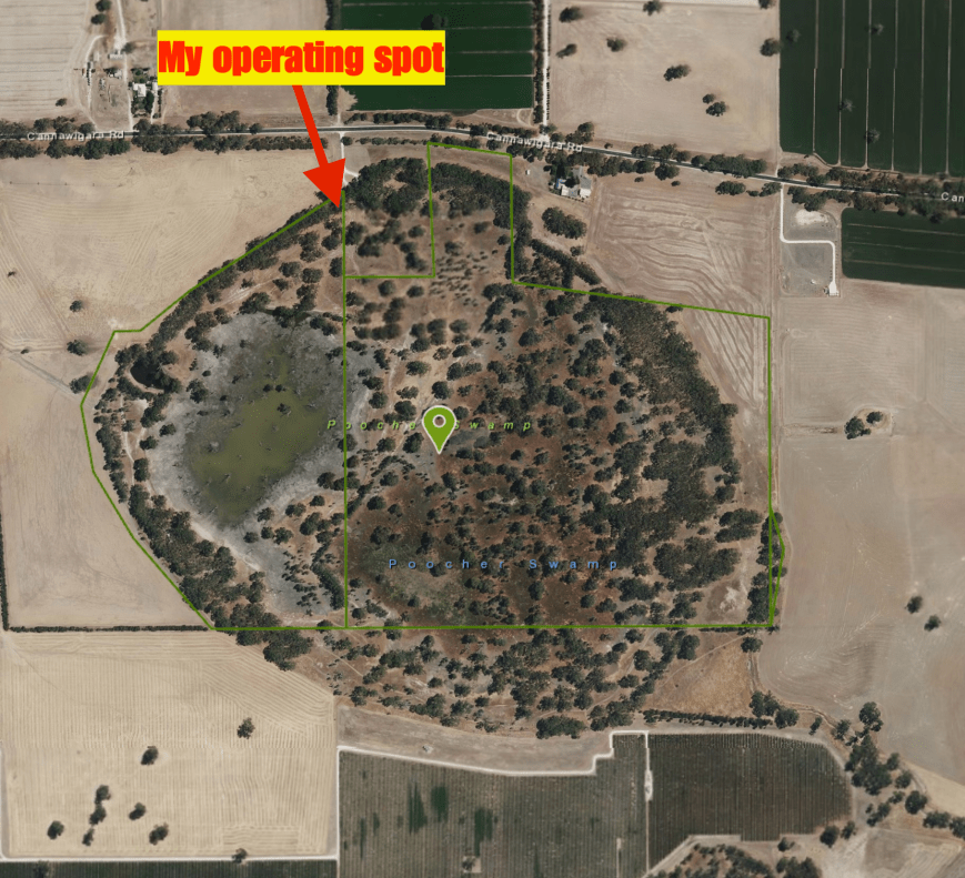
Above:- Aerial view of Poocher Swamp showing my operating spot. Image courtesy of Location SA Map Viewer.
Once I had set up it was almost dark, so I decided to kick off the activation on the 80m band. I self spotted on parksnpeaks and called CQ on 3.610 and this was answered by Adrian VK5FANA. This was followed by Gerard VK2IO, Compton VK2HRX, and then Peter VK3PF. Contact number 10, qualifying the park for me for VKFF, was a QSO with Bill VI50IARU3 in the Calliope Conservation Park VKFF-1499, just 9 minutes into the activation.
I logged a total of 26 stations on 80m from VK1, VK2, VK3, VK4, and VK5. Unfortunately callers then dried up, so I headed off to 7.144 on 40m. First in the log there was Ray VK4NH. After working 11 stations, Bill VI50IARU3 gave me a shout, and remained on the frequency with me, working the hunters, giving them 2 parks at the same time.
Contact number 44 was a QSO with Gerard VK2IO, who was struggling to hear me. We moved frequency 3 times as Gerard was suffering from noise, but we eventually made it. At just after 6.30 p.m. local time I had 46 contacts in the log after an hour in the park, which really amazed me. Time to pack up and hit the road.
THANKYOU to everyone who called me during my 5 activations. And a BIG THANKYOU to those who took the time to spot me, as I had no internet coverage at some of the parks.
I worked the following stations on 80m SSB:-
I worked the following stations on 40m SSB:-
References.
Birds SA, 2018, <https://birdssa.asn.au/location/poocher-swamp-game-reserve/>, viewed 12th July 2018
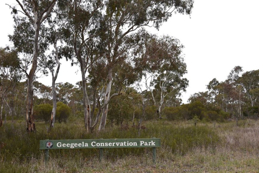
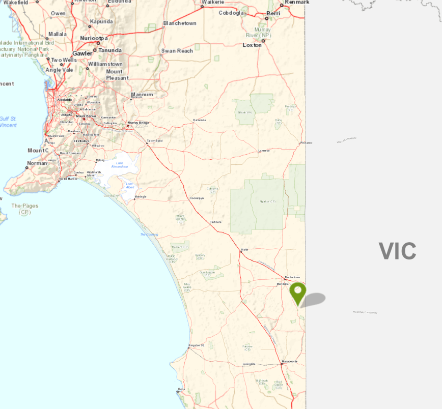
My fourth planned park for the day (Tuesday 10th July 2018) was the Geegeela Conservation Park 5CP-075 & VKFF-0883. This was to be another unique park for me as an activator.
Geegeela is situated about 298 km south east of Adelaide and about 27 km south of the town of Bordertown.
Above:- Map showing the location of the Geegeela Conservation Park. Map courtesy of Location SA Map Viewer.
The Geegeela Conservation Park, which is 858 hectares in size, was established in July 2005. It takes its name from the Hundred of Geegeela which was originally known as the Hundred of Pflaum. However this was changed in 1918 as a result of the anti German sentiment during World War One. Geegeela is derived from the Aboriginal Tjitjila language meaning ‘wallaby’.
Above:- Aerial view of the Geegeela Conservation Park. Image courtesy of google maps
The Geegeela Conservation Park is home to numerous rare and endangered plant and animal species. More than 90 species of native bird have been recorded in the park. These include 17 threatened species within South Australia and 29 which have an identified conservation rating within the south east region. The park provides critical habitat for the endangered South-Eastern Red-Tailed Black Cockatoo and Swift Parrot. Other vulnerable listed birdlife includes the Brown Quail, Little Lorikeet, Brolga, Blue Winged Parrot, and the rare Shining Bronze-cuckoo, Blue Faced Honeyeater and Flame Robin.


The park consists of Blue Gum, and River Red Gum woodland. The woodland and shrubland ecosystems found in the park are threatened on both State and National levels.


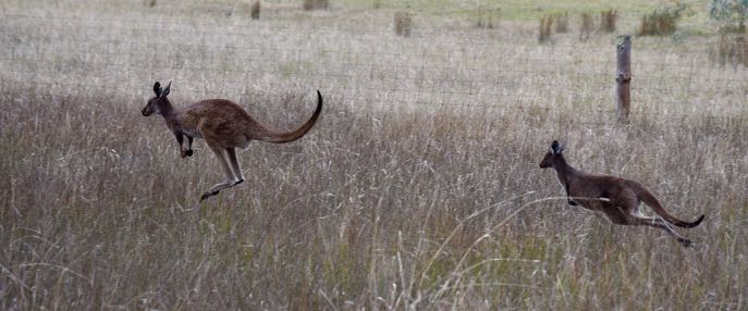
As I travelled along the Frances Road and then My Mi Mi Road, there were signs warning of kangaroos.
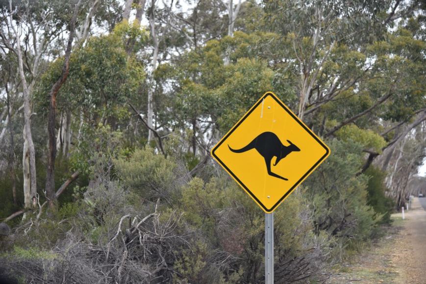
And it didn’t take me long to bump into a few of the locals.
I soon reached the north eastern corner of the park which was well signposted.
A short distance from the NE corner, I found an opened gate and drove along the perimeter track.
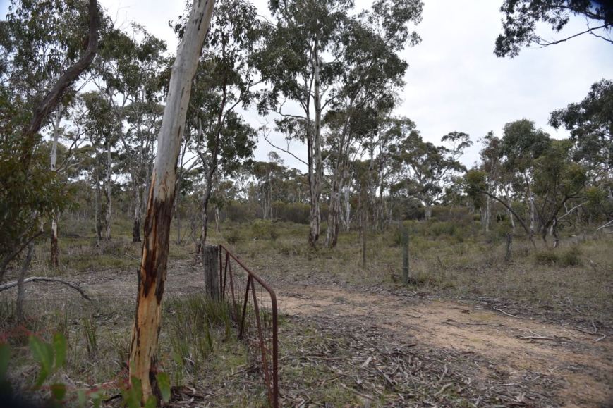
I set up about 20 metres from the gate. There was plenty of room to string out the 20/40/80m linked dipole.
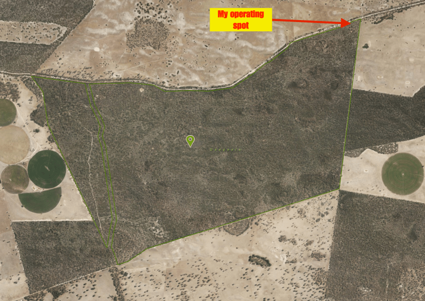
Above:- Aerial view of the Geegeela Conservation Park, showing my operating spot in the north eastern corner of the park. Image courtesy of Location SA Map Viewer.
Fortunately I had some internet coverage from Geegeela and was able to throw up a self spot on parksnpeaks. I called CQ on 7.144 and this was answered by Adrian VK5FANA, followed by John VK2YW, Gerard VK2JNG mobile, and then John VK4TJ. Contact number 10, with Linda VK7QP, came 7 minutes into the activation. I had qualified the park for the VKFF National program.
The 40m band was in excellent shape, and within 37 minutes I had my 44th contact in the log, with a QSO with Rob VK2TTY. After logging 49 contacts on 40m I moved off to 3.610 on the 80m band, which was also in great shape. I logged 16 stations on 80m from VK2, VK3, VK5, and VK7.
I then put out about 10 or so CQ calls on 14.310 on the 20m band, but had no takers, so with it now being 4.10 p.m. local time, it was time to pack up and move on. I still had a 2 & 1/2 hour drive to get home and I was contemplating activating the Poocher Swamp Game Reserve.


I worked the following stations on 40m SSB:-
I worked the following stations on 80m SSB:-
References.
National Parks South Australia, 2018, <https://www.environment.sa.gov.au/parks/find-a-park/Browse_by_region/Limestone_Coast/geegeela-conservation-park>, viewed 12th July 2018
State Library South Australia, 2018, <http://www.slsa.sa.gov.au/digitalpubs/placenamesofsouthaustralia/G.pdf>, viewed 12th July 2018
My third park for the day was the Bangham Conservation Park 5CP-009 & VKFF-0869, which is located about 304 km south east of Adelaide and about 34 km south east of the town of Bordertown. Again, this was to be another unique park for me as an activator.
Above:- Map showing the location of the Bangham Conservation Park. Map courtesy of Location SA Map Viewer.
The Bangham Conservation Park is a large park, comprising 869 hectares. In 1971 the land was offered to the South Australian State Government for conservation purposes. At the time it consisted of 6.76 square kilometres of “native scrub” and 1.25 square kilometres of “cleared land” with the majority of the latter occupying its south-east corner.
There was a subsequent study which revealed that the land was used by the endangered Red-Tailed Black Cockatoo. This made the land “particularly suitable for conservation purposes”. Bangham was first proclaimed on the 22nd November 1973, with further land being added on 18th February 2010. A Government survey of 1908 described the area as having the ‘greater part undulating white sand, with stringybark, buck honeysuckle, heath, yacca with a few pines’ and supporting ‘little grass’, and considered to be ‘inferior pasture’.

Above:- Aerial view of the Bangham Conservation Park, looking north. Image courtesy of google maps
Three major associations located in the park are: South Australian Blue Gum (Eucalyptus leucoxylon) open forest – woodland; River Red Gum (E. camaldulensis) – in areas subject to inundation; and Brown Stringybark (E. baxteri) open forest – low open forest.


The park takes its name from the nearby area of Bangham. Edward Bangham had land in the area in the 1840’s. The Bangham Hall opened in 1953 and can still be found on the Frances Road.
Birds SA have recorded a total of 135 species of native birds in the park including Sulphur-crested Cockatoo, Crimson Rosella, White-throated Treecreeper, Brown Treecreeper, Superb Fairywren, Tawny-crowned Honeyeater, Red Wattlebird, Black-chinned Honeyeater, Little Corella, Spiny-cheeked Honeyeater, Blue-faced Honeyeater, White-fronted Chat, Crested Bellbird, Hooded Robin, and Grey-crowned Babbler.
I turned into the park off the Frances Road and travelled down a sandy 4WD track which then took me to the northern boundary of the park.

Above:- the track in the park
I pulled the Hi Lux off to the side of the track and set up ‘the shack’ comprising the Yaesu FT-857d (set at 40 watts output) and the 20/40/80m linked dipole.

Above:- Aerial shot of the Bangham Conservation Park showing my operating spot in the northern section of the park. Image courtesy of Location SA Map Viewer.
Once I had set up I headed to 7.144 and found Alan VK2MG/p calling CQ from the Tuggerah State Conservation Area VKFF-1383. After logging Alan, Park to Park, I moved down the band to 7.135 and called CQ. Unfortunately I had no internet coverage and was hoping that someone would find me. Fortunately Peter VK3PF did. I then logged Peter VK7LCW, Adrian VK5FANA, and Gerard VK2JNG mobile.
Contact number 10 was a QSO with Brett VK2VW, nine minutes into the activation. I logged 33 stations on 40m from VK2, VK3, VK4, VK5 and VK7. I then moved to 3.610 on the 80m band and logged 11 stations from VK2, VK3, and VK5. This included Andrew VK1DA/3 who was activating SOTA summit Goonmirk Rocks VK3/ VG-048 in the Errinundra National Park VKFF-0158. Contact number 44 was Geoff VK3SQ.
I then QSYd to the 20m band and called CQ on 14.310. First in the log on that band was Ray VK4NH, followed by John VK4TJ and Rob VK4SYD.
I had qualified the park, with 49 contacts in the log, and time to head to my fourth park, the Geegeela Conservation Park.
I worked the following stations on 40m SSB:-
I worked the following stations on 80m SSB:-
I worked the following stations on 20m SSB:-
References.
Birds SA, 2018, <https://birdssa.asn.au/location/bangham-conservation-park/>, viewed
State Library South Australia, 2018, <http://www.slsa.sa.gov.au/digitalpubs/placenamesofsouthaustralia/>, viewed
Wikipedia, 2018, <https://en.wikipedia.org/wiki/Bangham_Conservation_Park>, viewed
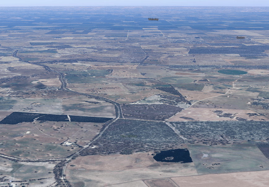
My second park for the day (Tuesday 10th July 2018) was the Pine Hill Soak Conservation Park 5CP-181 & VKFF-1078. This was to be another unique park for me as an activator in the WWFF program and the VK5 Parks Award.
Pine Hill Soak is located about 301 km south east of Adelaide, and about 30 km south of the town of Bordertown.
Above:- Map showing the location of the Pine Hill Soak Conservation Park in the south east of South Australia. Map courtesy of Location SA Map Viewer.
Pine Hill Soak Conservation Park is 51 hectares (130 acres) in size and was proclaimed on the 17th September 1987. The park’s name is derived from a soak known as Pine Hill Soak which is located near the conservation park’s southern boundary. A soak or soakage, is a source of water and is so called because the water generally seeps into the and, and is stored below, sometimes as part of an ephemeral river or creek.
Above:- Aerial view of the Pine Hill Soak Conservation Park. Image courtesy of google maps
The park is bounded on the western side by the Frances Road, McCarthy Road to the north and by a vehicle track to its east and south boundaries. The park consists of brown stringybark open forest, with desert banksia, and woodland of river red gum and South Australian blue gum with an open understorey of grasses, sedges and herbs. The park also contains native pine.


After I left Custon Conservation Park I put Pine Hill Soak into the GPS. All was looking good until the GPS took me down a dead end road (Ivan Road) and into a farmer’s property. So it was a manual look at some maps, and back to the Frances Road. I then encountered a flock of sheep and alpaccas who were out grazing on the side of the road under the watchful eye of a local farmer.


I soon reached the north western corner of the park and travelled down McCarthy Road, which is a no through road. I travelled down a sandy track which passed through the park. I found a clearing in the scrub and pulled off the track and set up. I ran the Yaesu FT-857d and the 20/40/80m linked dipole for this activation.
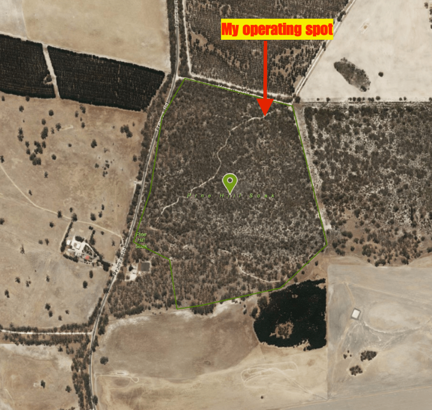
Above:- Aerial view of the Pine Hill Soak Conservation Park, showing my operating spot in the northern section of the park. Image courtesy of google maps
First in the log was Rob VK2QR with a big signal, followed by Geoff VK3SQ, Neil VK4HNS, and then Ron VK3AHR. Within 6 minutes I had contact number 10 in the log, with a QSO with Vinnie VK2VIN in Wollongong.
The band had really opened up nicely since my first activation, with some excellent signals. Contact number 44, a QSO with Rob VK3QJ/2 came within 28 minutes. I logged a total of 50 stations on 40m from VK1, VK2, VK3, VK4, VK5 VK7 and New Zealand. I was pleased as always to log regular park hunter Andrei ZL1TM. I also made two Park to Park contacts, with Gerard VK2JNG/p in the Bullala National Park VKFF-0580, and Alan Vk2MG/p in Tuggerah State Conservation Area VKFF-1383.


So with the park qualified, everything from here on in was going to be a bonus. I lowered the squid pole and inserted the links for the 80m section of the dipole. First in the log on 3.610 was Mick VK3GGG with a big big 5/9 plus signal. This was followed by Ron VK3VBI and then John VK5BJE. I logged a further 4 stations on 80m from VK2, VK3 and VK5.
To finish off the activation I called CQ on 14.310 and logged John VK4TJ and then Ray VK4NH and his 2 other callsigns.
I had a total of 62 contacts in the log and it was now 1.10 p.m. local time, and time for me to pack up and head off to the Bangham Conservation Park.
I worked the following stations on 40m SSB:-
I worked the following stations on 80m SSB:-
I worked the following stations on 20m SSB:-
References.
Wikipedia, 2018, <https://en.wikipedia.org/wiki/Pine_Hill_Soak_Conservation_Park>, viewed 12th July 2018
Wikipedia, 2018, <https://en.wikipedia.org/wiki/Soakage_(source_of_water)>, viewed 12th July 2018
Yesterday I travelled down to the south east of South Australia, near the South Australia (VK5) and Victoria (VK3) State border, and activated a total of 5 parks. They were all new ones for me as an activator in both the VK5 Parks Award and WWFF. In all it was around a 550 km round trip from my home.

Above:- Map showing my route for the day. Map courtesy of plotaroute.com.
My first park for the day was to be the Custon Conservation Park 5CP-051 & VKFF-1024, which is located about 297 km south east of Adelaide and about 25 km south east of the town of Bordertown. It is located about 4 km from the State border.

Above:- Map showing the location of the Custon Conservation Park. Map courtesy of Location SA Map Viewer.
I was unable to find any information on this park on the internet. The Department for Environment and Water (DEWNR) website does not have any information on the park and records that there is no Park Management Plan for Custon.
The park takes its name from the little town of Custon, about 8 km from the town of Wolseley. Custon was proclaimed on the 8th December 1881 and was named by Governor Jervois after Rev William A. Purey-Cust, the elder son of the Dean of York, who married his daughter, Lucy Caroline. Prior to the proclamation of the town the local railway station was known as ‘University Blocks’. The Custon School opened in 1919 and closed in 1956.
The park is located at the corner of Bangham Road and Pier Point Road.
Above:- Aerial shot of the Custon Conservation Park, looking north. Image courtesy of google maps.
Custon is quite a small park and contains Gum forest. The vegetation is quite sparse in some parts of the park.


The park is surrounded by cleared farming land. The next nearest park is the Pine Hill Soak Conservation Park, located about 14 km to the south.


I left home at about 6.30 a.m. and headed south east along the South Eastern Freeway and out onto the Dukes Highway (the main highway between Adelaide & Melbourne). My first stop was in the little town of Coonalpyn, an aboriginal word meaning ‘Barren Woman’. I called in to the Silo Cafe for a coffee and a bacon & egg sandwich. I took the time to admire the artwork on the silos, which I have seen many times before. The murals were completed in early 2017 by artist Guido van Helten and feature local Coonalpyn Primary School children.


After reaching the town of Bordertown, I travelled south out of the town along the Frances Road. I stopped briefly to have a look at the historic Wiese’s Horse Dip. It was built in 1931 by local landholders using timber from nearby bulloak trees. Its main function was to control a parasitic itch in working Clydesdale horses. This malady caused great discomfort to the Clydesdale horses manes and tailes, so much so that they used to rub constantly against fences and so cause damage to many fence lines. Horses were walking into the dip, and due to the horses’ size, the operators bucketed and sponged the solution over the horses to complete the task. The dip was used until the outbreak of World War II and the eventual decline of the Clydesdale working horse.


I soon reached the Custon Conservation Park which was well signposted in the north western corner.
As I arrived at the park I noticed a Black Shouldered Kite sitting up in a tree. He/she was kind enough to sit there for a while, whilst I took a few photographs.

This Australian Shellduck was also observed in the park.

I drove south along Bangham Road, following the western boundary of the park, and found that the fence had fallen over near the south western corner. So I pulled off the road and set up just inside the fenceline. There was a nice break in the scrub here as well, with plenty of room to string out the 20/40/80m linked dipole.

Above:- An aerial view of the Custon Conservation Park, showing my operating spot in the south western corner of the park. Image courtesy of Location SA Map Viewer.
First in the log for the activation was Gerard VK2JNG on 7.144, followed by Geoff VK3SQ, Deryck VK4FDJL, and then Neil VK4HNS. Despite it being a week day, there was a steady flow of callers, and within 7 minutes I had contact number 10 in the log (John VK4TJ), thus qualifying the park for VKFF.
I logged 18 contacts before things slowed down and I headed off to the 80m band. There were very few VK3’s and VK5’s logged on 40m and I suspected I was a little too close for both on 40m. So I was hoping for a few Victorian and South Australian contacts on 80. First in the log on 3.610 was Peter VK3PF, followed by David VK5PL in the Barossa Valley, and then Mick VK3GGG in western Victoria. All had strong 5/9 signals and reciprocated with 5/9 for me.
I logged 8 stations on 80m from VK2, VK3 & VK5. Sadly despite the band conditions being very good on that band, callers dried up quickly. So I moved to 14.310 on the 20m band where I logged 12 stations from VK2, VK3 and VK4.


To complete the activation I moved back to 40m where I logged a further 10 stations from VK2, VK3, VK4, VK5, and VK6. It was great to log Hans VK6XN all the way on the other side of Australia. I also had a Park to Park contact with Gerard VK2JNG/p in the Bullala National Park VKFF-0580.
I worked the following stations on 40m SSB:-
I worked the following stations on 80m SSB:-
I worked the following stations on 20m SSB:-
References.
State Library South Australia, 2018, <http://www.slsa.sa.gov.au/digitalpubs/placenamesofsouthaustralia/>, viewed 11th July 2018
Wikipedia, 2018, <https://en.wikipedia.org/wiki/Coonalpyn,_South_Australia>, viewed 11th July 2018
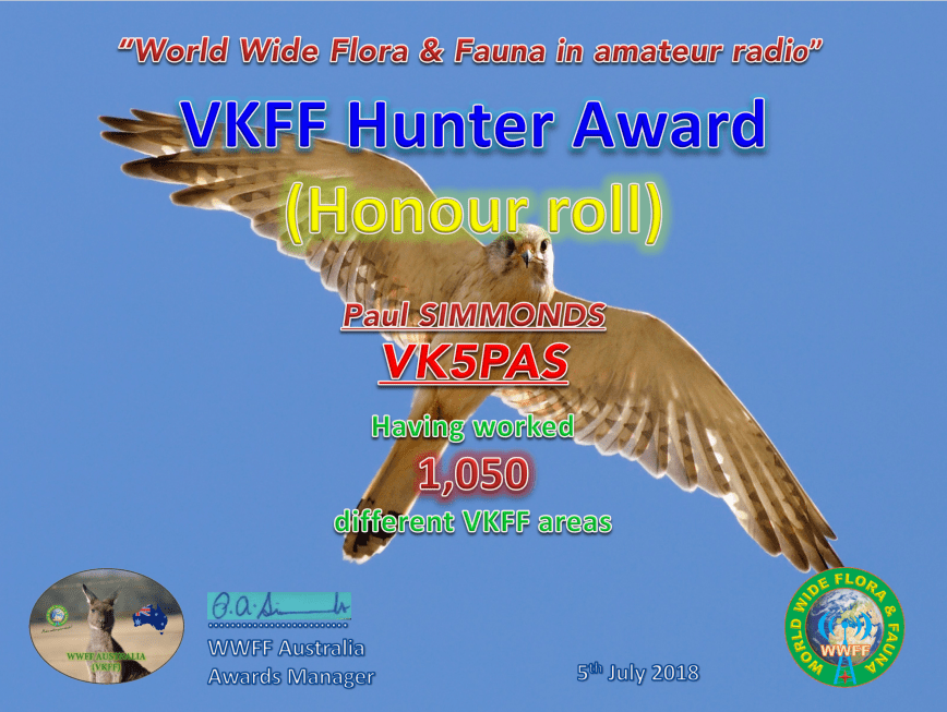
Today I qualified for my latest VKFF award certificate, the VKFF Hunter Honour Roll 1,050, which is issued for having worked 1,050 different VKFF references.
The certificate features a photograph of a Whistling Kite.
Many thanks to all of the VKFF activators.
Between Friday the 22nd June 2018 to Tuesday 26th June 2018, I was privileged to use the special call of VI70MI. This was courtesy of Lee VK3GK, who is the custodian of this special call.
VI70MI is issued to commemorate 70 years of ANARE (Australian National Antarctic Research Expeditions) for Macquarie Island, which since 1947 have served Australia in the south polar regions.
Where is Macquarie Island? It lies in the southwest Pacific Ocean, about halfway between New Zealand and Antarctica, at 54° 30′ S, 158° 57′ E.
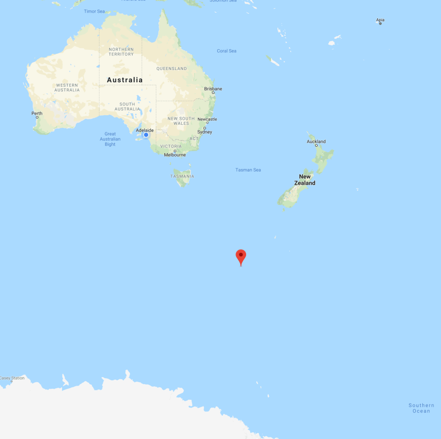
Above:- Map showing the location of Macquarie Island in the sub Antarctic. Map courtesy of google maps.
Macquarie Island, affectionately known as ‘Macca’, is regionally part of Oceania and politically a part of Tasmania, Australia, since 1900, it became a Tasmanian State Reserve in 1978 and was inscribed on the World Heritage List in 1997.
The island is named after the former New South Wales Governor, Lachlan Macquarie. It is believed that Macquarie was first discovered on 11th July 1810, by Captain Frederick Hasselborough of the brig Perseverance who sighted the island during a sealing voyage out of Sydney.


The island has numerous bird species including Royal penguins, Macquarie shags, King penguins, southern rockhopper penguins and gentoo penguins. Macquarie has been identified by BirdLife International as an Important Bird Area because it supports about 3.5 million breeding seabirds of 13 species.


Mammals found on the island include subantarctic fur seals, Antarctic fur seals, New Zealand fur seals and southern elephant seals, of which over 80,000 individuals of this species can be found on Macquarie.
Australia’s Sir Douglas Mawson, in 1911, established Macquarie Island’s first scientific station. In 1912, Australians established the first radio link between Australia and Antarctica by setting up a radio relay station on Wireless Hill on Macquarie Island, which could communicate with both Mawson’s main expedition group at Commonwealth Bay, and Australia. The first ANARE expedition to Macquarie Island was in March 1948.


Interestingly, there has never been a ham radio DXpedition to Macquarie Island. The only activities on the island are from hams stationed on Macquarie. Currently there is only one active amateur on Macquarie Island, and that is Norbert VK0AI.


I operated from both home and out in the field using the call. On Monday I activated the Scott Conservation Park using the call, and on Tuesday evening I activated the Ferries McDonald Conservation Park.
Unfortunately work got in the way during my first days of operation. I was on Afternoon shift, but gave the call a run in the morning and the early afternoon. But on Monday and Tuesday I had 2 days off and had some fun on 20m and 15m with the DX.
My very first contact using the call was with John VK5BJE on 40m.
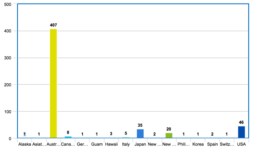
I ended up working a total of 535 stations on 2m FM and 10, 15, 20, 40, & 80m SSB. I worked a total of 16 DXCC entities, 23 of the 50 US States, 15 out of 40 of the ITU zones, and 11 IOTA entities.
The bar graph below shows my contacts broken down by DXCC entity.
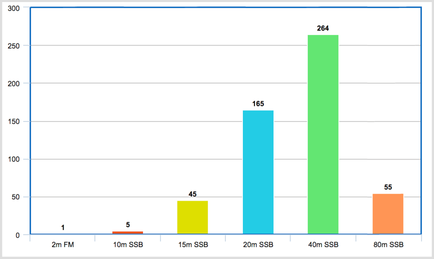
Most of my contacts, 264 of them, were on 40m SSB, followed by 165 on 20m SSB. Sadly I left my run on 10m a little too late on Sunday. By the time I got there from 20m where I was working into North America, the 10m band had almost completely closed.
The map below shows my contacts around the globe using VI70MI. Unfortunately no contacts into Africa or South America.
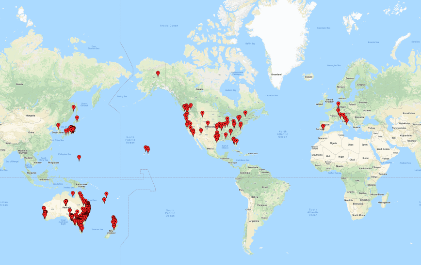
The vast majority of my contacts were around Australia. A total of 407 Australian stations were logged. I worked all States/Territories from VK1-VK8.
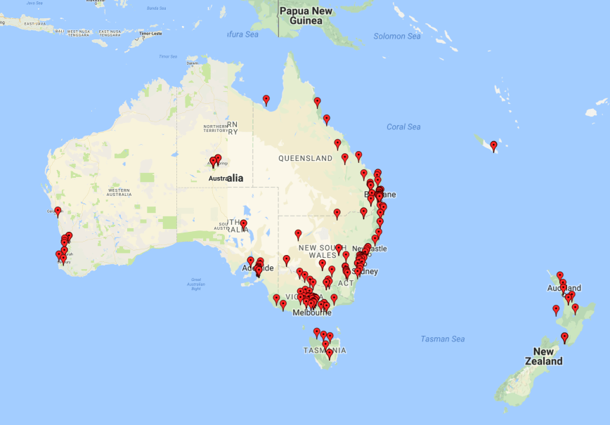
I had some reasonable openings on 20m short path into North America, with stations worked in the USA, Canada, and Alaska.
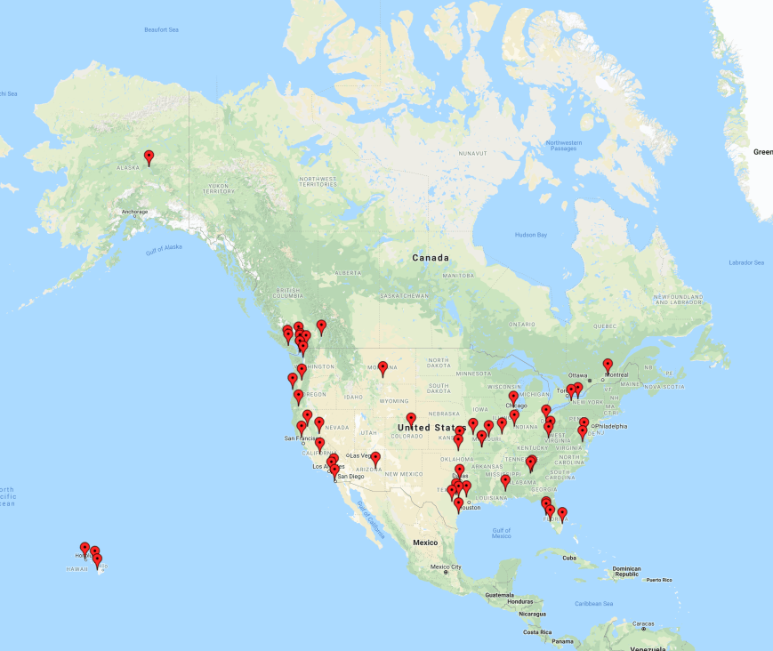
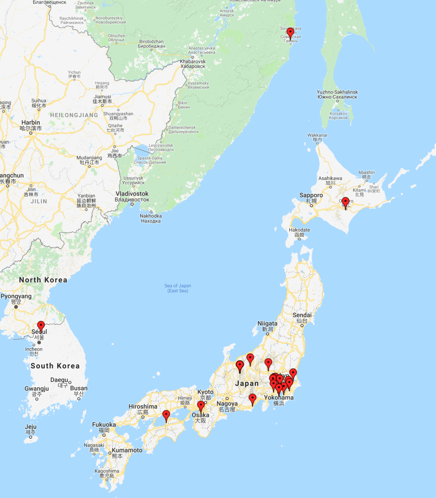
On Sunday I had a small, but very enjoyable opening on 15 metres, to Japan. Whilst beaming in that direction I also logged one station from South Korea, and another in Asiatic Russia. I did not hear a single station on 15m before calling CQ, and then all of a sudden, following a few CQ calls, and a spot on the DX Cluster, the band came alive.
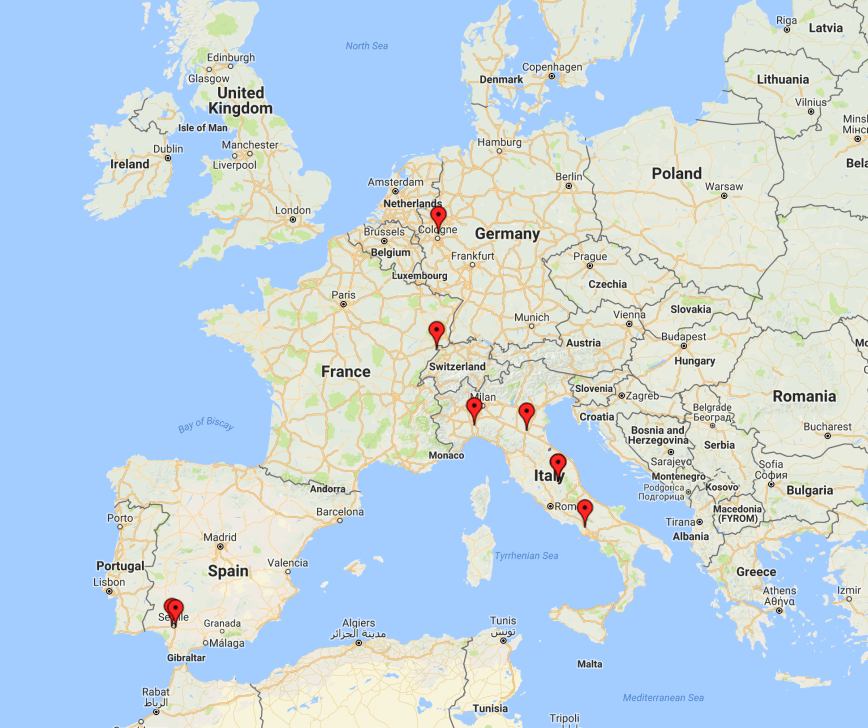
Sadly there was very little long path propagation on 20m to Europe. I only logged 9 European stations, from Germany, Italy, Spain, and Switzerland. And due to work and some other committments, I did not stay up late or get up early in the morning to take advantage of the short path to Europe.
Here is a short video of how I sounded to Tony VK5TT.
I had a lot of fun using the call and would like to thank Lee VK3GK, and everyone who called me. VI70MI will be on air until the end of 30th August 2018. So if you missed me, there will be plenty of opportunities of getting this special call in your log.
A special commemorative QSL card will be available after completion of the activation via M0OXO our QSL manager.
https://www.m0oxo.com/oqrs/logsearch.php
OQRS will be available and also LOTW.
Please do not send your QSL cards via the VK buro as they are not required – Please just request your buro cards by OQRS for a fast return!
References.
Australian Government, 2018, <http://www.antarctica.gov.au/about-antarctica/history/stations/macquarie-island>, viewed 28th June 2018
Wikipedia, 2018, <https://en.wikipedia.org/wiki/Macquarie_Island>, viewed 28th June 2018
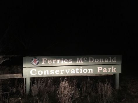
Last night (Tuesday 26th June 2018) I decided at the last minute to head out to active the Ferries McDonald Conservation Park 5CP-067 & VKFF-0881 using the special call of VI70MI. This was my last night using the call, and as I currently have no dedicated 80m antenna at home, I headed out for an evening park activation, particularly focussing on the 80m band.
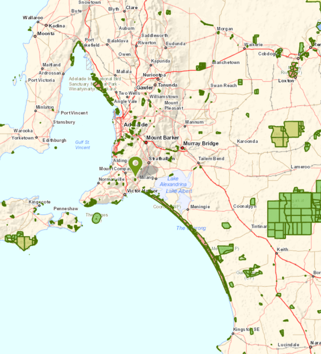
The Ferries McDonald Conservation Park is about 70 km east of Adelaide and about 25 km south west (by road) from Murray Bridge.

Above:- Map showing the location of the Ferries McDonald Conservation Park. Map courtesy of Location SA Map Viewer.
To get to the park I travelled east along the South Eastern Freeway until I got to the Monarto turnoff. I then travelled along Ferries McDonald Road at a slow pace, as there were lots of kangaroos on the road. The area is also known to be the home of the endangered Mallee Fowl and there are signs in place reminding you to drive with care with respect to the local wildlife.


The Ferries McDonald Conservation Park is quite a large park, comprising 842 hectares of dense mallee scrub. Much of the land surrounding the current park was cleared years ago for agriculture, but a few rocky outcrops, not suitable for farming practices, preserved fragments of the original vegetation. The park is home to a variety of rare and endangered plant species. Resin Wattle (Acacia rhetinocarpa) is a compact, resinous spreading shrub that grows up to 2 metres in height with bright yellow flowers. It is endemic to South Australia and is only found in a few locations across the state including three populations in Ferries McDonald CP.
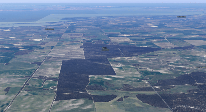
Above:- Aerial shot showing the Ferries McDonald Conservation Park, looking south out towards the Coorong and the Southern Ocean. Image courtesy of google maps
On 28th July 1938 the area was gazetted as a Closed Area for Birds and Animals, creating the first reserve specifically for mallee fauna. The area was named after Robert Sweet McDonald, the donor of much of the land. In 1953 an addition to the park was made with monies from a bequest from James Ferries, thus creating the Ferries-McDonald Reserve. The area was previously known as Chauncey’s Line Scrub.
A number of native animals call the park home including the Red, Western Grey and Euro Kangaroos.
A focus within the park has been the protection of the Malleefowl (Leipoa ocellata), a native bird species that originally inhabited much of the natural mallee environment. Malleefowl are listed as vulnerable nationally but are critically endangered in the Northern Territory and Western Australia.
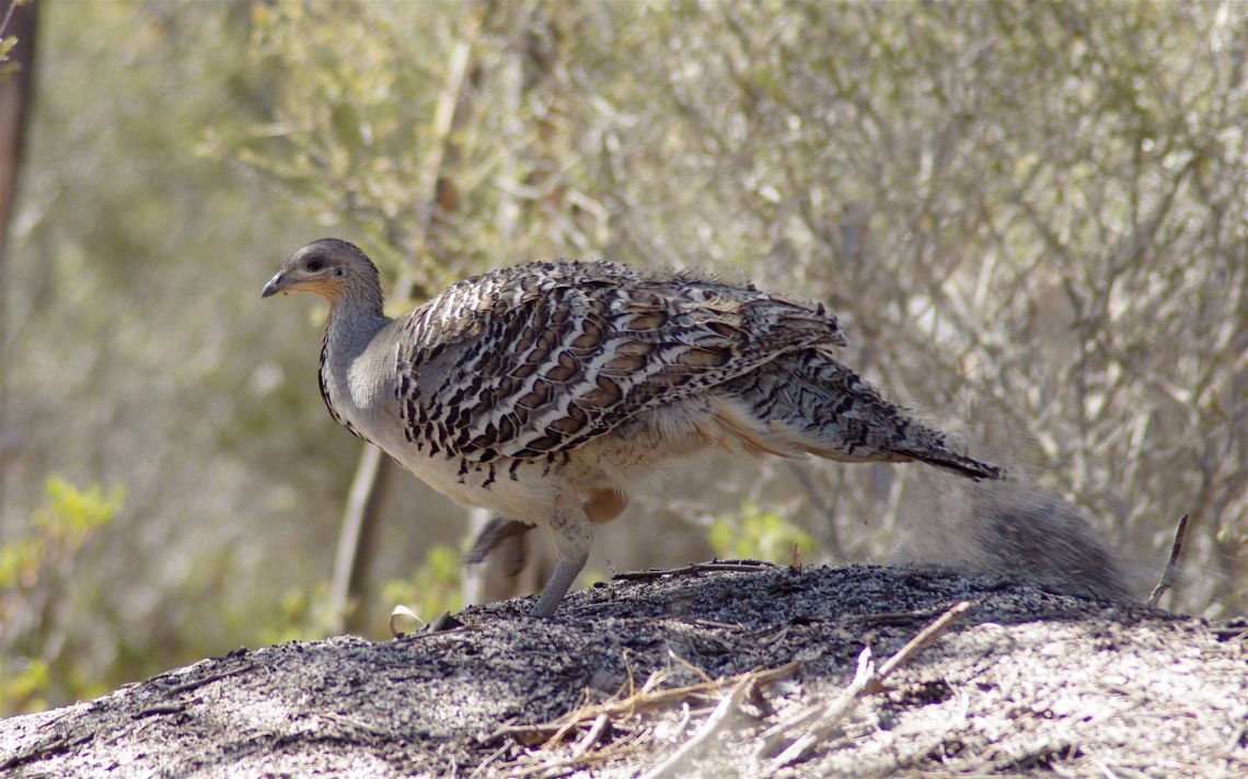
Above:- Malleefowl. Image courtesy of wikipedia.
Birds SA have recorded a total of 89 native birds in the park including Galah, Variegated Fairywren, Weebill, Southern Scrub Robin, Australian Magpie, Australian Golden Whistler, Grey Shrikethrush, Spotted Nightjar, Tawny-crowned Honeyeater, Chestnut-rumped Hornbill, White-browed Scrubwren, and White-winged Triller.
I set up in my normal operating spot, in the carpark in the south eastern corner of the park. I braved the cold during this activation, with the temperature dropping down to 4 degree C during my time in the park. I ran the Yaesu FT-857d, set at 40 watts output, and the 20/40/80m linked dipole.

Above:- Aerial shot of the park showing my operating spot. Image courtesy of Location SA Map Viewer.
First in the log on 3.603 on 80m was John VK5NJ at Mount Gambier with a strong t/9 plus signal. This was followed by Adrian VK5FANA on the Yorke Peninsula who was equally as strong. Adrian gave me a 40/9 signal report. Conditions on the band were great, with no man made noise of course in the park, but also limited static crashes.
I logged 29 stations on 80m from VK1, VK2, VK3, VK4, VK5, VK6, VK7 and New Zealand. This included a Park to Park contact with Gerard VK2IO/p who was activating the Eusdale Nature Reserve VKFF-1929.
I then moved to 40m as Les Vk5KLV up at Port Augusta was hoping to log me and did not have a dedicated antenna for 80m. Sadly Les was unable to hear me on 40m. But I did log 10 stations including Greg VK8GM in Alice Springs.
I moved back to 80m before packing up. I logged a further 13 stations, including Les VK5KLV who was able to make it with his compromise 80m antenna. I was pleased to get Les in the log.
I was now freezing and it was time to pack up and head home to the warmth. I had a total of 52 contacts in the log which I was very happy with.
I worked the following stations on 80m SSB:-
I worked the following stations on 40m SSB:-
References.
Birds SA, 2018, <https://birdssa.asn.au/location/ferries-mcdonald-conservation-park/>, viewed 27th June 2018
Wikipedia, 2018, <https://en.wikipedia.org/wiki/Ferries_McDonald_Conservation_Park>, viewed 27th June 2018
On Monday 25th June 2018 I headed to the Scott Conservation Park 5CP- & VKFF-0934 to activate the park using the special call sign of VI70MI. The special call issued to Commemorate 70 years of ANARE (Australian National Antarctic Research Expeditions) for Macquarie Island, which since 1947 have served Australia in the south polar regions.
Scott Conservation Park is about 75 km south of Adelaide and about 7 km north west of Currency Creek.
Above:- Map showing the location of the Scott Conservation Park. Map courtesy of Location SA Map Viewer.
The Scott Conservation Park is 210 hectares in size. The park was first proclaimed in 1969 and re-proclaimed as Scott Conservation Park on 27th April 1972. The park is relatively flat and is situated east of the Mount Lofty Ranges. The park consists of Blue and Pink gum woodlands


The park is a terrific piece of native scrub which is generally surrounded by cleared farming land. The next largest piece of scrub near Scott is the Cox Scrub Conservation Park.
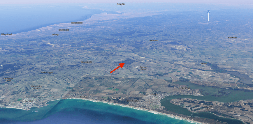
Above:- Aerial shot showing the location of the park on the Fleurieu Peninsula. Image courtesy of google maps
Birds SA have recorded a total of 148 native bird species at Scott. This includes Common Bronzewing, White-throated Treecreeper, Superb Fairywren, New Holland Honeyeater, Red Wattlebird, Grey Shrikethrush, Cockatiel, Eastern Rosella, Tawny-crowned Honeyeater, Restless Flycatcher, Hooded Robin, and Eastern Shriketit.
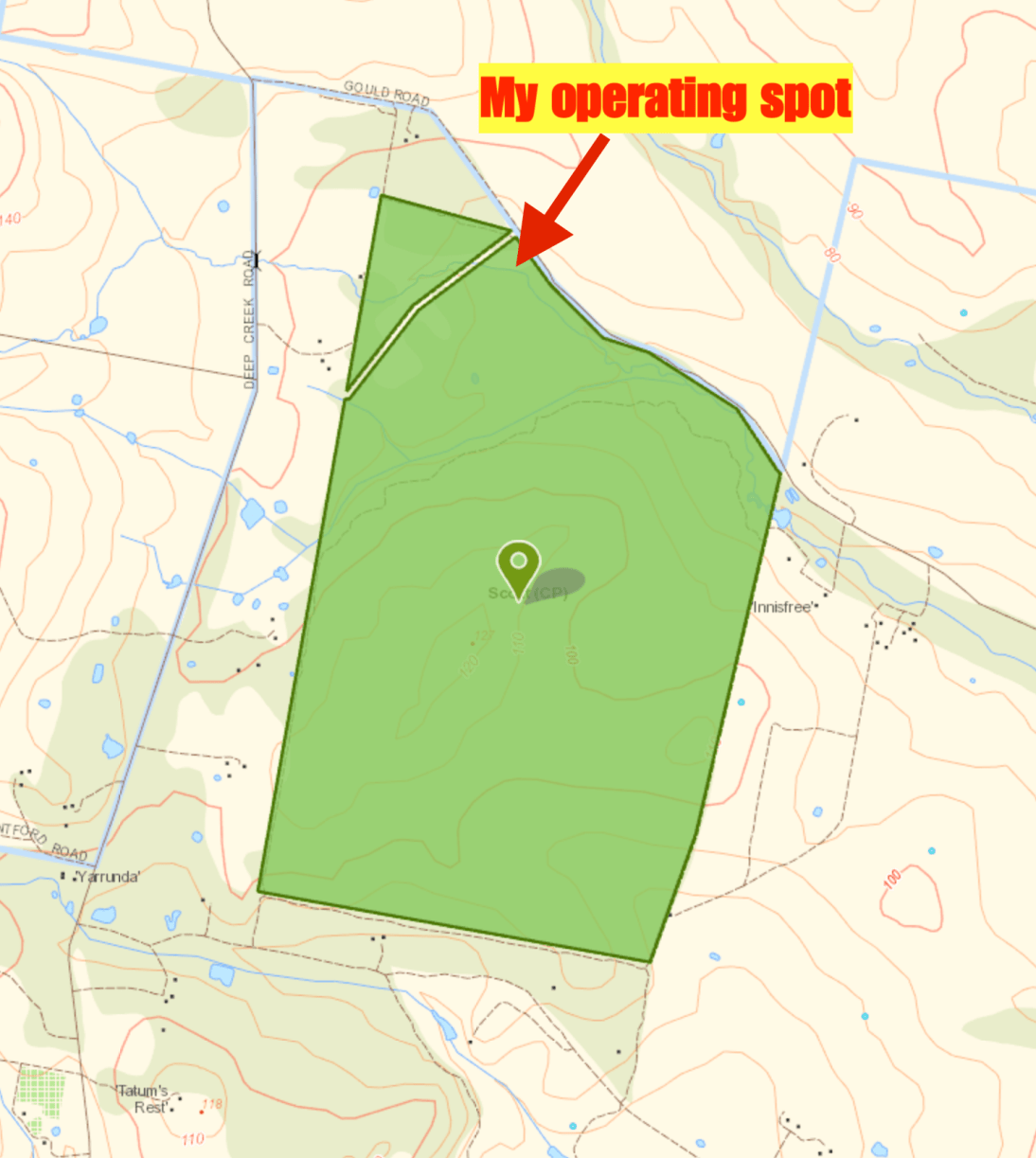
Above:- Map of the park showing my operating spot. Map courtesy of Location SA Map Viewer.
Unfortunately I did not plan this activation very well, and left home without the camera, and secondly with an almost flat mobile phone. So I was only able to take 3 photos during this trip to Scott. And I wasn’t able to self post on parksnpeaks and facebook, so I was relying upon the good will of park hunters.
I kicked off the activation by calling CQ on 7.144 which was answered by Geoff VK3SQ, followed by Lee VK3FLJD, and then Nick VK3ANL. Although it was a weekday I was pleased to have a good flow of callers eager to get the VI70MI callsign in their log.
I managed to log 31 contacts on 40m including two Park to Park contacts, with Bill VK4FW/p in the Sheep Island Conservation Park VKFF-1642, and Allan VK2MG/p in the Bouddi National Park VKFF-0049. I then lowered the squid pole and inserted the links for the 80m section of the dipole. I called CQ on 3.610 and thus was answered by Greg VK5GJ with a big 5/9 signal, followed by Hans who was also 5/9 plus. I was really pleased to log a total of 9 stations on 80m from VK3, VK5 and VK7.
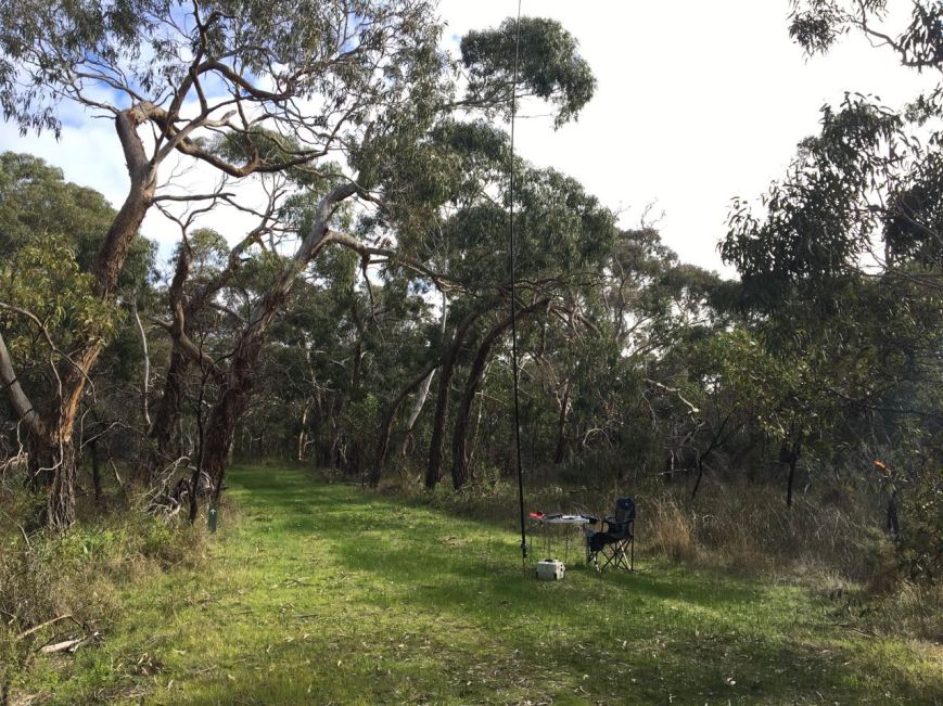
Above:- My shack for the morning. A nice setting.
I then headed to 20m and called CQ on 14.310. First in the log was Greg VK5GJ who had followed me from 80m. Next was regular park hunter John VK4TJ, who become contact number 44 in the log. This was followed by Bill VK4FW/p for another Park to Park contact from the Sheep Island Conservation Park.
With 11 stations in the log on 20m, I headed back to 7.144 on 40m where I logged 10 stations. This included Gerard VK2IO/p on SOTA peak Mount Walker VK2/ CT-019 and Peter VK3TKK/p in the Conglomerate Gully NCR VKFF-2297.
To complete the activation I headed down to 3.610 and logged Gerard VK2IO/p on his SOTA summit, and then Peter VK3TKK/p for another Park to Park. Last in the log was Peter VK3PF.
It had been a fun 90 minutes in the park and I had 64 contacts in the log, including five Park to Park contacts.
I worked the following stations on 40m SSB:-
I worked the following stations on 80m SSB:-
I worked the following stations on 20m SSB:-
References.
Birds SA, 2018, <https://birdssa.asn.au/location/scott-conservation-park/>, viewed 25th June 2018
Department of Environment and Natural Resources, 2011, ‘Parks of the Fleurieu Peninsula’.
Amateur Radio, Short Wave Listening, travel and history
Amateur radio experiences with VK1DA
Brisbane - Australia
german amateur radio station
Summits On The Air
SOTA on the peaks, wilderness QRP and some bushwalking
A fine WordPress.com site
Amateur Radio Adventures
Summits on the Ai
Amateur radio station from Belgium
Radio craft, homebrew, QRP/SOTA, AM
Ego loqui ad viros super montes
My adventures with Amateur Radio and Geocaching!
The rantings of VK2GAZ on his SOTA experiences in Australia
A survivor, with minor cuts and abrasions.
The Art and Craft of Blogging
The latest news on WordPress.com and the WordPress community.
Blog of Justin Giles-Clark VK7TW's SOTA and amateur radio adventures.
Occasional SOTA & Microwave operation
