The Sampson Flat fire has now burnt about 11,500 hectares (28,750 acres) of area. A watch and act warning is now in place. According to the CFS website, the fire continues to burn out of control on all flanks.
Below is a map of the fireground as of 9.30 p.m. last night.
I have left a message for Noel, the owner of the land that Mount Gawler is located on. I have offered any assistance that he may need. I am sure there are some other SOTA activators who would be prepared to offer their assistance. Noel has been very supportive of SOTA, so I think any help we can provide him would be a good thing.
There are also a number of amateurs who are located in the fire affected area, including my good mate Greg VK5LG, who fortunately to date has not suffered any property damage. My thoughts are with you Greg.
More information on the fire can be located on the Country Fire Service website at…..
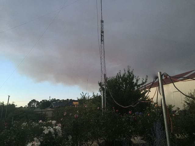
Most would know that there is a very large fire burning out of control in the Mount Lofty Ranges ‘Adelaide Hills’. The fire is currently threatening a number of homes. Below is a view of the fire from my backyard.
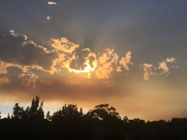
And this is the sunrise at home this morning, with the sun trying to break through the smoke.
Currently, the CFS urges anyone within the Mount Pleasant, Kersbrook, Gumeracha, Mount Torrens, Woodside, Lobethal, Inglewood, Upper Hermitage, Breakneck Hill, One Tree Hill township, Little Para Reservoir, Chain of Ponds, Houghton, Cudlee Creek, Lower Hermitage, Charleston, Birdwood, Lenswood, and Williamstown to LEAVE THE AREA NOW, AS THERE IS A HEIGHTENED RISK TO LIVES AND HOMES.
Fortunately I live about 20 km south of the southern boundary of the fire, and there is a lot of countryside between me and the fire. Earlier today the fire was heading south towards us, and one of the towns just 12 km from me, was issued with a warning to either leave or immediately enact their bushfire survival plan. The wind direction changed and the fire has moved off in different directions.
The Country Fire Service estimate that the fire has burnt about 10,000 hectares (about 24,700 acres) of farming land and bushland.
Below is a map showing the burnt area as of 1230 hours local time today. Six hours later, it is now even bigger.
I have tried contacting Noel, who is the property owner where the SOTA summit Mount Gawler VK5/ SE-013 is located. Sadly I have not been able to get through to Noel, so I am hoping that Noel and his property are okay. Mount Gawler is smack bang in the middle of the blackened area.
At this stage, it has only officially been recorded that 5 homes have been destroyed. However, unofficially, the authorities are saying that it is likely to be much higher…perhaps 3 dozen homes. Certainly from listening to the scanner today, firefighters and police reported multiple properties on fire and not saveable.
The towns of Gumeracha and Kersbrook have been spared, but only just (see the eastern side of the map above).
The fire has impacted on the Cudlee Creek Conservation Park. This park has apparently been destroyed. I have activated this park previously, and it is (was) a very beautiful park, home to many native animals and birds.
A number of other Conservation Parks are threatened including the Montacute Conservation Park, Black Hill Conservation Park, Warren Conservation Park, Cromer Conservation Park, and Porter Scrub Conservation Park. The beautiful Mount Gawler Native Forest Reserve has also been destroyed. I have activated park portable in all of these areas.
No matter what your religious persuasion may be…..say a prayer tonight for those that have lost their homes. It is certainly not a good situation. I can only imagine what it must be like to loose all of your possessions.
Fortunately the wind has signficantly dropped here, as has the temperature. Tomorrow we are expecting 31 c, Monday 34 c, 36 c on Tuesday, and then 37 c on Wednesday.
Updates on the fire can be found on the Country Fire Service (CFS) website at…..
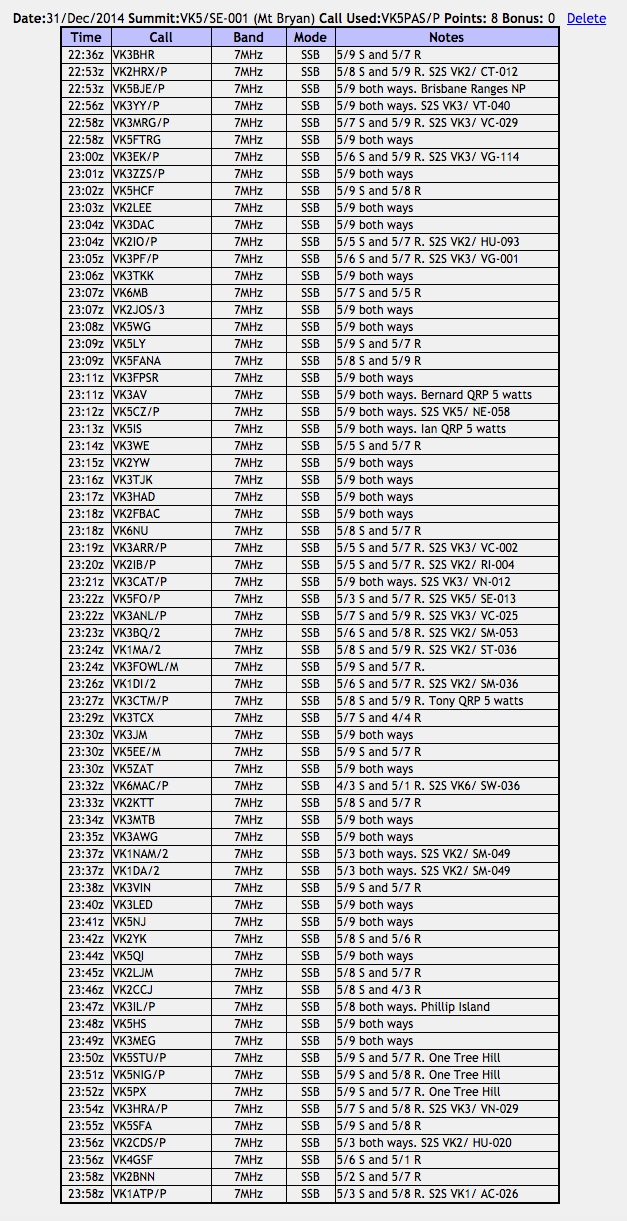
On Wednesday afternoon, my wife Marija and I headed north after finishing work in the city of Adelaide. Our destination was Burra, about 160 km north of Adelaide, in the Mid North of South Australia. Our intention was to activate Mount Bryan summit for the UTC rollover for the New Year. In the Summits on the Air (SOTA) program, activators are awarded points for activating a summit every calendar year. So this was a unique opportunity to get to the top of Mount Bryan and be awarded the 8 SOTA activator points for 2014, and then a further 8 activator points for 2015, when the new UTC day ticked over (10.30 a.m. South Australian local time).
map courtesy of mapcarta.com
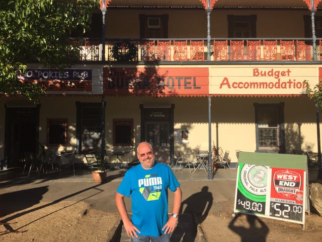
Our accomodation for the night was the Burra Hotel. This little pub offers affordable accomodation. Although not The Ritz, the room was clean and tidy, and the hotel staff were very friendly. I stayed here back in 2013 when I last activated summits in the area. After booking in, we had a walk around the Burra township, which is a pastoral centre and historic tourist town. Burra actually commenced its life as a single company mining township, that by 1851 was a set of townships collectively known as ‘The Burra’. The Burra mines supplied about 89 % of South Australia’s copper, and about 5 % of the world’s copper for about 15 years.
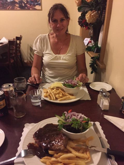
Unfortunately they were not serving meals at the Burra pub, so that night we had a meal at another one of the hotels in Burra, the Commercial Hotel. The meal there was very well priced and my rump steak was cooked to perfection. After our meal we retired to the main bar and chatted with some of the locals, whilst enjoying a few Bundy and cokes, and watching the 20-20 cricket at Adelaide Oval. We were in bed before midnight. Maybe that is a sign of us getting old. God help me when I’m 60!
For more information on Burra, please have a look at ‘The History of Burra’ website at…..
Back to some info on the Mount Bryan summit. Mount Bryan is 933 metres ASL and is worth 8 SOTA points. It is located in the South East Region of the South Australian SOTA Association. Mount Bryan is the highest summit in that Region. It has previously been activated by myself, Ian VK5CZ, John VK5BJE, and Bob VK5FO.
I last activated Mount Bryan summit in July 2013. For information on that activation, please have a look at my previous post…..
The famous Heysen trail heads up to the summit from Mount Bryan East Road. This is about a 2 hour walk. And it was a hot day. Armed with some prior information, and before heading north I contacted the Wildongoleechie Hotel at Hallett, and spoke to the owner, Marie. Via Marie, I got in contact with the land owner of the property, on which the road leading to the top of the summit is situated on. I subsequently contacted Tony and he confirmed that we could access the summit via his property. Contact details for Tony can be found on the SOTA notes for VK5/ SE-001.
After leaving Burra, Marija and I travelled north along the Barrier Highway, through the little township of Mount Bryan and then on to Hallett. We then turned right onto North Terrace and then onto Mount Bryan East Road. We travelled north along Mount Bryan East Road and reached the intersection with Scrub Road. We took a sharp right to continue along Mount Bryan East Road for a number of km. Rather than turning right onto the required road, Banbury Road, we continued along Mount Bryan East Road. We were lost. Oh, sorry Marija…I was lost!
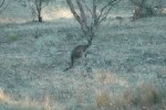
As we travelled along Mount Bryan East Road, we encountered numerous Western Grey kangaroos. So it was slow going. And we also saw a cheeky fox on the road, who wasn’t keen to move.
Fortunately we came across a fantastic farmer, who gave us directions and pulled me out of my dilema and frustration. So, please look out for Banbury Road which runs off Mount Bryan East Road.
This slideshow requires JavaScript.
As you travel along Banbury Road you will see a gate on the southern side of the road, which warns that the land is private property. Please do NOT enter the land unless you have the permission of the land owner. We then followed this dirt track, up through some gates, to the summit. The track leading to the summit is not passable for a conventional vehicle. A 4WD vehicle is definitely required as there are lots of washaways.
This slideshow requires JavaScript.
The very first European to sight what is now known as Mount Bryan was the explorer, Edward John Eyre (1815-1901). He explored the area in July 1839.
Above- Edward John Eyre. Courtesy of wikipedia.org
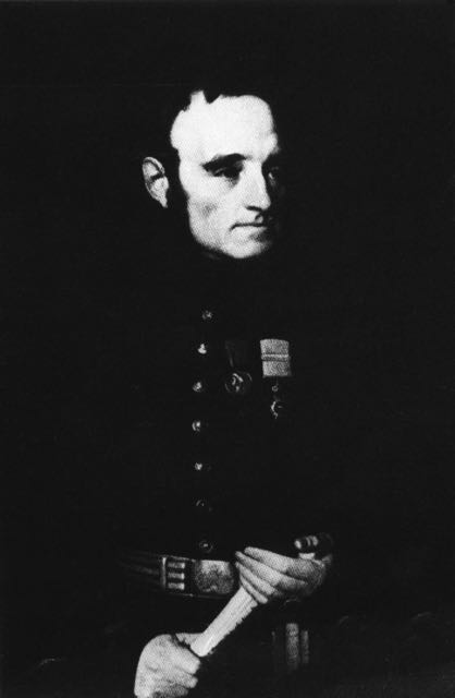
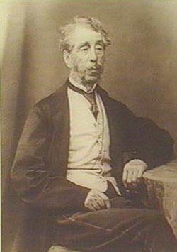
The area was next explored in December 1839, by Lieutenant-Colonel George Gawler (1795-1869) the second Governor of S.A. & Captain Charles Sturt (1795-1869), and their party. This included a young man called Henry Bryan, in whose honour, Gawler named the summit.
Above- Cptn Charles Sturt & Gov Gawler. Courtesy of wikipedia.org
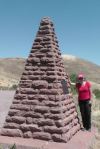
In 1842, the Colonial Surveyor, Lieutenant Edward Frome (1802-1890) , further explored the area and he erected a cairn on the summit. He is reported to have been the first European to have climbed the summit. Frome later visited the area, at which time he climbed the summit and made a number of sketches.
Above- Edward Frome. Courtesy of wikipedia.org
Below is a sketch of Mount Bryan by Frome.
courtesy of ebooks.adelaide.edu
It never ceases to amaze me, the stupidty of some people and organisations. And here is another very sad example. Mount Bryan summit later became a Government Water Reserve and in 1970, the S.A. Water Authority demolished Frome’s historic cairn, to make way for other engineering works. A piece of South Australia’s history gone forever!
But there are always saviours. In 2002, Glen Tiver, erected the current cairn in memory of his forebears and early explorers. Tiver’s forebears owned the property called ‘Rupera’, which encompassed Mount Bryan and its environs.
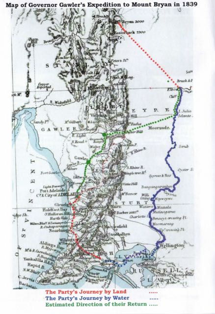
In December 1839, Governor Gawler and Captain Charles Sturt set out ‘to examine the land along the Murray river, with the hope of finding fertile country; and also to determine the capabilities of river and lake for inland navigation’. We know a lot about this expedition due to the efforts of Sturt’s biographer, Beatrix Sturt, who was also Sturt’s daughter in law. Sturt informed her directly re the expedition, and she also had access to all of his private papers.
The expediiton was first discussed by Gawler and Sturt in November 1839. They proposed to cross Lake Alexandrina from Currency Creek, near the present town of Goolwa. They were to proceed up the Murray to the Great Bend, and then return overland to Adelaide. The expedition party consisted of Governor Gawler, his 15 year old daughter Julia, Captain Charles Sturt and his wife Charlotte, Eliza Arbuckle who was Charlotte Sturt’s maid servant, Henry Inman Superintendent of Police, Henry Bryan a house guest of Gawler, WIlliam Pullen the Colonial Marine Surveyor, ArthurGell who was Gawler’s Personal Secretary, John Craig Aide to Gawler, Isaac Hearnshaw Aide to Gawler, and local aboriginal interpreters.
The Party set off from near present day Goolwa, and sailed in 4 little boats across Lake Alexandrina from Currency Creek, and proceeded up the Murray River to current day Morgan. After their arrival on Tuesday, the 10th December, at what was described as the ‘Great bend’ in the river at Morgan, they set up camp at the entrance of Bryan (Burra) Creek. The following day on Wednesday the 11th December, Gawler, Sturt, Inman, Craig, and Bryan, set off on horseback with a week’s provisions and 2 barrels of water to explore the country.
It was at approximately 12 noon on the 11th December, 1839, on a small hill to the north east of the campsite, that Gawler saw a mountain in the distance and immediately named it Mount Bryan after his young friend, Henry Bryan.
However by the first night, when about ’32 miles’ from the river, it was discovered that the barrels had leaked and much of the water had evaporated in the extreme heat.
A second day of extreme weather left barely a trace of water in the barrels and the situation was critical. Smoke was seen in the vicinity of Mount Bryan and the Party assumed that this indicated the presence of aboriginals, and thus water. Gawler later stated:-
“While contemplating the scene about us, smokes were observed to arise on Mount Bryan. Smokes indicate Natives, and Natives indicate the neighbourhood of water. Our casks had leaked, the bung had escaped from one of them, and the consequence was that our stock of water was just exhausted…..On the following morning, leaving Captain Sturt and Mr H Bryan in charge of our provisions and packhorses, I and Mr Inman set out in search of the Natives and water, but after toiling over the spurs and through the gullies during the morning of another hot day we could not find either. We found an extinguished Native fire and a ruined Native hut, but that was all, and we returned to the party to say that no alternative remained but to press through the night for our station on the Murray….”
It was at this time that Sturt bled one of the remaining three horses and all partook in this desperate attempt at survival.
On Friday the 13th of December, with all of their water gone and the temperatures rising, Sturt recommended that Gawler and Bryan set off on the strongest horses to seek help. They were about ’65 miles’ (110 kms) from the camp on the river. It was organised that Sturt, Inman, and Craig would follow a short time later.
On Saturday the 14th of December, Gawler and his horse could not proceed any further due to the heat and lack of water. Gawler and Bryan then swapped horses so that Bryan could ride the Governor’s horse slowly for the remaining ’12 miles’ to the camp, and Gawler would ride ahead.
By Sunday the 15th December, Gawler had reached the camp, however he had lost sight of Bryan at this time. He was followed soon after by Sturt, Inman and Craig. But there was no sign of Byran.
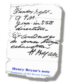
On Monday the 16th with the assistance of a local aboriginal, the group tracked the hoof prints of Bryan’s horse, about ‘five miles’ through the bush. They located Bryan’s blankets, coat, and stockings, and Gawler’s saddle, bridle, and telescope. On a scrap piece of paper, dated 9 p.m. Sunday 15th, Bryan had written that he ‘had been detained by exhaustion‘ but was going to the south-southeast.
“A second careful search at this spot disclosed the tree to which he had tethered his horse. The animal on escaping had taken a course due west to the hills with his rope trailing after him, and he eventually found his way back to Adelaide. But not search could disclose even to a native’s piercing eye any footprint or other mark in the direction indicated. Repeated efforts were made; they examined every bush, fired at intervals, constantly shouted; but to no purpose, nor was any further trace of ‘Bryan’ ever found”.
Bryan’s horse amazing eventually made its way back to Adelaide, with its hoofs grown to enormous lengths. And as for Bryan, he was never seen again, and has not been declared missing or presumed dead, nor has a death certificate been issued.
Gawler later wrote:-
“I never had so deep a regard for any young man that I had known for the same length of time, his character, looking at it with the severity of a Christian eye, was more faultless that that of any other individual of the same age”.
Marija and I set up the gear at the trig point. Or what is left of the trig point. There are now just three 1.5 metre high metal poles, painted bright blue. I used one of the poles to secure my 7 metre squid pole to, with the use of a few octopus straps. For this activation I used my Yaesu FT-857d, and ran 30 watts. The antenna was the 40m/20m linked dipole.
Prior to calling CQ, I had a look around the 40m band, and worked a few Summit to Summit stations including Compton VK2HRX on VK2/ CT-012, Glenn VK3YY on Spjon Kopje VK3/ VT-040, and Marshall VK3MRG on Briarty Hill VK3/ VC-029. I also tracked down John VK5BJE who was portable in the Brisbane Ranges National Park in Victoria.
I then proppped on 7.085 and called CQ and this was answered by Tom VK5FTRG in Millicent, and then Rob VK3EK who was portable on Fainting Ridge, VK3/ VG-114. I went on to have 69 QSOs prior to the UTC rollover. This included 21 Summit to Summit contacts before the UTC rollover.
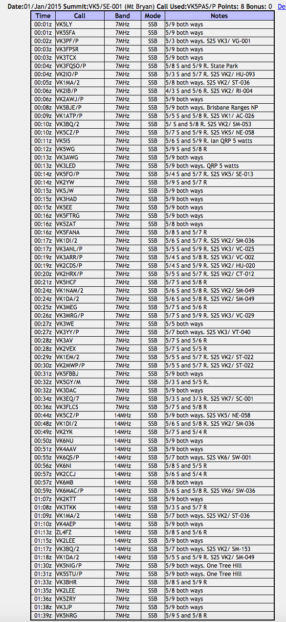
My first contact after the UTC rollover was with Larry VK5LY in The Riverland. This was followed by Steve VK5SFA, and then Peter VK3PF who was portable on SOTA peak VK3/ VG-001. I went on to work a total of 72 stations after the UTC rollover. This included 26 Summit to Summit contacts.
This slideshow requires JavaScript.
During this activation I worked a total of 23 unique summits in VK1, VK2, VK3, VK5, VK6, & VK7:-
VK1/ AC-026, Booroomba Rocks
VK2/ CT-012
VK2/ HU-020
VK2/ HU-093, Mount Elliott
VK2/ RI-004, Mount Jergyle
VK2/ SM-036
VK2/ SM-049, Mount Tumanang
VK2/ SM-053
VK2/ ST-022 Wyanbene Caves Mountain
VK2/ ST-036, Spring Hill
VK3/ VC-002, Mount Donna Buang
VK3/ VC-025, Mount Dandenong
VK3/ VC-029, Briarty Hill
VK3/ VG-001, Mount Cope
VK3/ VG-114, Fainting Range
VK3/ VN-012, Mount Despair
VK3/ VN-029 Federation Range
VK3/ VT-040, Spion Kophe
VK5/ NE-058, Mount Ngadjuri
VK5/ SE-013, Mount Gawler
VK6/ SW-001, Bluff Knoll
VK6/ SW-036, Mount Dale
VK7/ SC-001
The following activators were worked:-
Paul VK1ATP/p
Andrew VK1DA/2
Ian VK1DI/2
Mark VK1EM/2
Matt VK1MA/2
Andrew VK1NAM/2
David VK2CDS/p
Compton VK2HRX/p
Bernard VK2IB/p
Gerard VK2IO/p
Andrew VK2MWP/p
Nick VK3ANL/p
Andrew VK3ARR/p
Andrew VK3BQ/2
Tony VK3CAT/p
Rob VK3EK/p
Rik VK3EQ/7
Allen VK3HRA/p
Marshall VK3MRG/p
Peter VK3PF/p
Glenn VK3YY/p
Ian VK5CZ/p
Bob VK5FO/p
Anthony VK6MAC/p
Matt VK6QS/p
After a total of 2 & 1/2 hours on the summit, I had a total of 146 contacts in the log on 40m ssb and 20m ssb. I had 69 contacts before the UTC rollover and then a further 72 contacts after the UTC rollover. I also managed a total of 47 Summit to Summit contacts, with a total of 260 S2S points. Of the 18 alerts on SOTAWatch for pre UTC rollover, I managed to make contact with 13. And there were 5 alerts for activations after the UTC rollover. I managed to work 3 of those. There were many other activators who did not place an alert on SOTAWatch, that I was fortunate enough to get in the log.
This activation was a lot of fun and I will certainly try to activate another summit this year for the New Year rollover. After getting down from Mount Bryan, we headed for the WIldongoleechie Hotel, but sadly it was closed. So instead, we travelled back into Burra and had a feed at the Royal Exchange Hotel. Again, this was an excellent meal at a very good price.
The following stations were worked before the UTC rollover:-
The following stations were worked after the UTC rollover:-
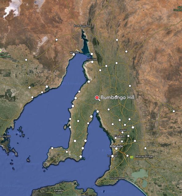
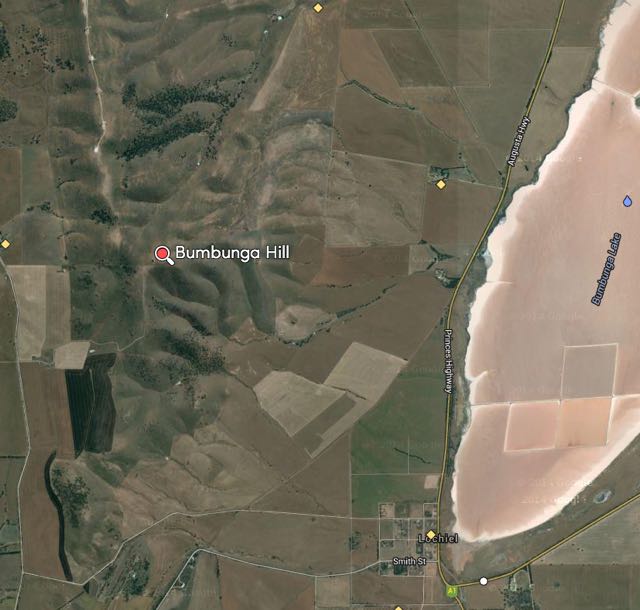
On Sunday morning (28th December 2014), Marija and I had intended on activating Mount Remarkable, VK5/ NE-010. But to be honest, we were quite exhausted from the 10 km walk the day earlier, when we had activated The Battery, VK5/ NE-055. So we chose an easier option. We were heading south back home, which would take us passed Illawarra Hill, Bumbunga Hill and South Hummocks. I tried calling the owner of the land that Illawarra Hill is located on, but could not get through. So I tried the land owner for the next summit south, Bumbunga Hill. John agreed there was no problem. So after packing our gear, that is where Marija and I headed…..Bumbunga Hill, VK5/ SE-015.
Bumbunga Hill is located near the town of Lochiel, in the Mid North of South Australia, about 130 km north of Adelaide, on the Augusta Highway. Bumbunga Hill is 413 metres ASL and is worth 1 SOTA point.
Map courtesy of mapcarta.com
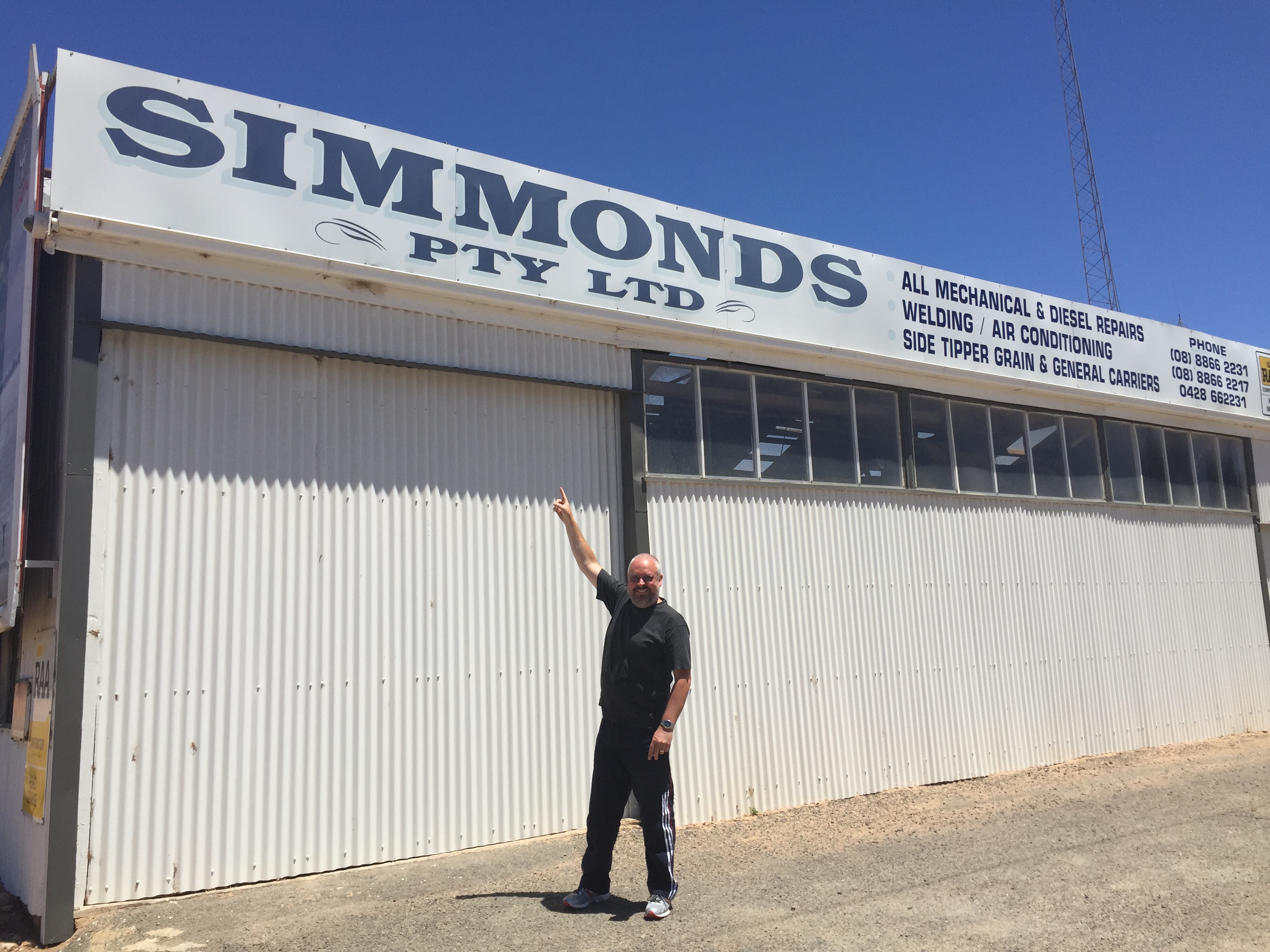
The summit is located on private property, so PLEASE obtain permission before entering onto the summit. Details of the owner can be located on http://www.sota.org.uk. Access is via Landslide Road, which runs off Smith Street. Smith Street is located on the western side of the Augusta Highway. I can never miss that street because on the corner is a business sharing my sirname….
The land owner, John was kind enough to unlock the main gate for us. At this entrance point you will see a shed and an old house ruin set back in the paddock. If you see them, you are at the right gate. However, access is not possible unless you contact John first. In any event, the gate is normally locked. We continued along the dirt track leading to the summit, passing throug a few more gates in the paddocks. The track becomes progressively more rocky and rough, with lots of washaways. I would not attempt this is in a conventional vehicle, but it is easily passable in a 4WD. Once we got close to the summit, we parked the car and walked the remainder of the way.
map courtesy of mapcarta.com
I last activated this summit in April, 2013. More information on that activation can be found at…..
I noted this time that the old trig point had been removed. All that is now left of where it once stood, are three blue painted upright poles. Just ideal to attach the squid pole to, with the assistance of some octopus straps. And for this activation I had a few of the creature comforts, including a fold up chair, courtesy of Marija.
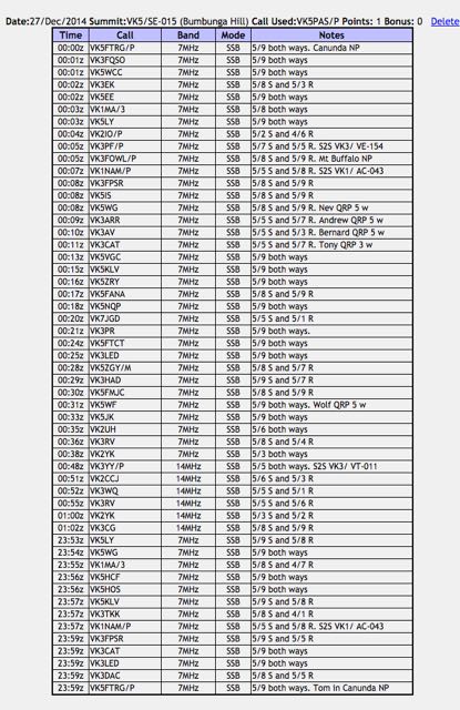
I managed to set up by 2353 UTC (10.23 a.m.) with only a few minutes to spare before the UTC ollover. In that short window, I managed to work 13 stations in VK1, VK3, & VK5. The first four contacts were with Larry VK5LY in The Riverland, Nev VK5WG in the Mid North, Matt VK1MA/3, and Col VK5HCF in Mount Gambier. I was also called by Andrew VK1NAM who was portable on Mount Stromlo, VK1/ AC-043. I was very pleased, my first summit to summit contact for the weekend. My final contact before the UTC rollover was Tom VK5FTRG who was portable in the Canunda National Park, in the South East of South Australia. This park qualifies for the World Wide Flora Fauna (WWFF) program and the VK5 Parks Award.
This slideshow requires JavaScript.
After the UTC rollover I worked a further 34 stations on 40m ssb in VK1, VK2, VK3, VK5, & VK7. This included a few more summit to summit contacts, including Peter VK3PF portable on VK3/ VE-154; and Andrew VK1NAM on Mt Stromlo VK1/ AC-043. I was also fortunate enough to work Julie VK3FOWL portable in the Mount Buffalo National Park, which qualifies for the Keith Roget Memorial National Parks Award (KRMNPA) and the World Wide Flora Fauna program (WWFF).
I then slipped up to 20m and worked a further 6 stations in VK2 and VK3. Conditions on 20m were not great, with lots of QSB present. But I did manage to sneak in another summit to summit. This time with Glenn VK3YY who was portable on SOTA peak Mount Tamboritha, VK3/ VT-011, which is also located in the Alpine National Park. So another KRMNPA and WWFF contact as well.
So after a little over an hour on the top of the hill, I had a total of 53 contacts in the log. It was getting hot, Marija was getting a little impatient (had read all her magazines), and I was getting hungry. So it was off to Port Wakefield for some lunch at the bakery.
Although Bumbunga Hill is only worth 1 point, the views from the top are spectacular. It has great take off in all directions. And access is easy. All in all a great summit. And again thanks to John, the land owner, who kindly allowed us access. We touched base with him again as we left the property, and he was very pleased we enjoyed the trip to the top.
Following our activation of the Whyalla Conservation Park, Marija and I continued on to the little town of Melrose, which is nestled below the impressive Mount Remarkable summit, in the southern Flinders Ranges. From Whyalla we travelled north to Port Augusta and then travelled south along Highway A1 (Augusta Highway). We then turned left onto Horrocks Pass Road/Main North Road, and travelled towards Wilmington.
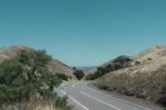
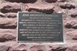
On the way to Wilmington we passed through Horrocks Pass, and we stopped off at the monument for John Horrocks, after which the pass was named. This is well worth a look. The story of Horrocks is a very interesting one. John Ainsworth Horrocks (1818-1846) was a pastoralist and explorer. In 1846, Horrocks led an expedition of 6, for a planned 4 month expedition to search for new agricultural lands near Lake Torrens. Between the 16th-19th August 1846, the expedition crossed the Flinders Ranges via Horrocks Pass. Horrocks and his team travelled with a camel, two carts, six horses, and twelve goats. Horrocks noted that the camel was very temperamental, often biting the humans and goats.
Image courtesy of images.slsa.sa.gov.au
However, the camel was able to carry up to 350 pounds (158.7 kg), which was vital for the anticipated trek across some very arid land. On September 1st, Horrocks was preparing to shoot a bird on the shores of Lake Dutton. While Horrocks was reloading his gun, the kneeling camel moved, which resulted in Horrocks catching the cock of the gun. The gun discharged, resulting in Horrocks loosing the middle fingers of his right hand and a row of teeth. Horrocks subsequently died of his wounds , about 3 weeks later, on September 23rd. And what of the naughty camel? Horrocks had ordered that it be shot.
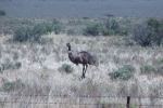
Plenty of emus out here.
And kangaroos
The monument to John Horrocks
Horrocks Pass, looking west
After leaving the Horrocks monument, we continued east and detoured to Hancock’s lookout. This is well worth taking the 7 km drive on the dirt road from the bitumen. On the way we saw numerous emus feeding in the farmer’s paddocks. Fortunately, none of them ventured out in front of the vehicle. Hancock’s lookout offers spectacular views of Spencer Gulf and the Port Augusta area.
This slideshow requires JavaScript.
After Hancock’s lookout, we continued on to Wilmington and then travelled south on Horrocks Highway/Main North Road to Melrose. We had booked in to stay for one night at the Melrose cabins which are run by the Melrose Hotel. This is the second time we have stayed here, and we highly recommend the cabins. They are well priced, clean and comfortable.
This slideshow requires JavaScript.
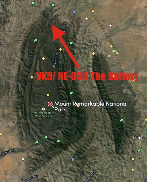
After lunch at the cabin, which consisted of schnitzel, roast potatoes, pumpkin, roast carrots, and salad, courtesy of my loving mother in law, we headed back out for our second activation for Saturday 27th December, 2014, which was The Battery, VK5/ NE-055, which is located within the Mount Remarkable National Park. So a triple whammy. A SOTA summit, a WWFF (VKFF) park, and a VK5 Parks award park.
Map courtesy of mapcarta.com
Marija and I travelled north along Horrocks Highway/Main North Road and then turned left onto Alligator Gorge Road and travelled south west until we reached the entrance to the Mount Remarkable National Park. We continued south west through the park until we reached Alligator Lodge which was on our left. Directly opposite is a campground, which is blocked off for vehicles. Look for Gate 5. There is also a sign here indicating that The Battery is 4.5 km away (the summit is a bit further). We parked the car on the south eastern side of the road and commenced the walk down the 4WD track towards the summit.
map courtesy of mapcarta.com
I would describe the walk as moderate but still quite taxing. The first 4 km involves a few inclines. However it is the last 1 km that is the hardest. There are some steep inclines and lots of rocks. The ground is very unsteady under foot. In many parts, the authorities have placed mesh to prevent slipping. But there are some spectacular views along the way, and once you reach the top, you are rewarded with a magnificent view of the surrounding countryside and Spencer Gulf. The track is quite well signposted.
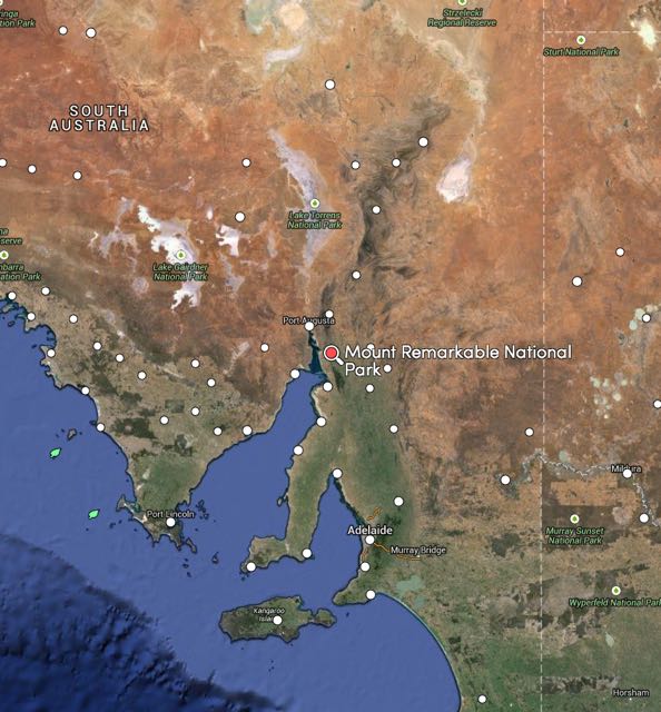
Mount Remarkable National Park is located about 45 km north of Port Pirie. Access to the park is either via the Augusta Highway via Mambray Creek, via Melrose, or via Alligator Gorge (our route). A fee of $10.00 is charged for vehicular entry, which we paid the night before online. Please note, that park entry fees now need to be paid online prior to visiting the park. Cash payments are no longer an option in this park.
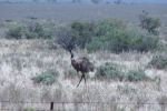
The park is 16,000 hectares in size and stretches from the coastal plain adjacent to Spencer Gulf, across the ranges, to Mount Remarkable on the edge of the Willochra Plain in the east. The park is full of kangaroos, Euros, Emus, and other wildlife.
The summit, Mount Remarkable, was named by explorer, Edward John Eyre in June 1840. The local aboriginal Nukunu people, refer to it was ‘Wangyarra’. The word ‘aara’ meaning running water. Alligator Groge and Mambray Creek were dedicated as National Pleasure Resports in 1952. These areas were added to and became managed by the National Parks Commission during the 1960’s. Following the enactment of the National Parks and Wildlife Act, 1972, Alligator Gorge, Mambray Creek and Mount Remarkable were proclaimed as the Mount Remarkable National Park. Additional portions of land have been added to the park since that time.
This slideshow requires JavaScript.
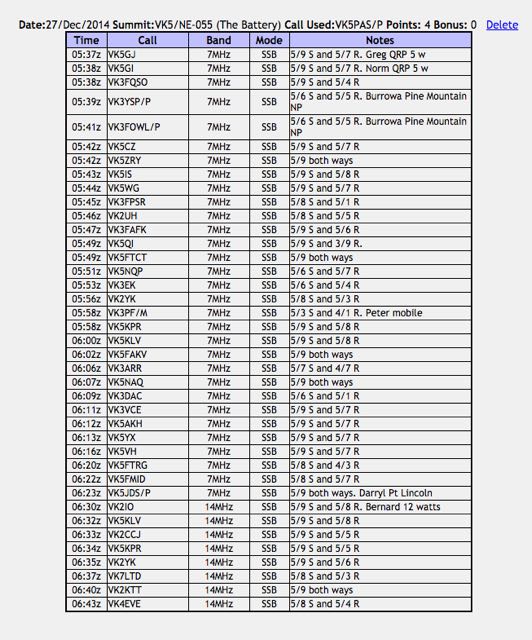
The Battery is 765 metres above sea level and is worth 4 points. This was the first time I had activated this summit. It had only been activated previously by Ian VK5CZ in June 2013 and April 2014.
For this activation I ran my little Yaesu FT-817nd, 5 watts and my 40m/20m linked dipole, supported on a 7 metre squid pole. Marija and I improvised and used a fallen tree branch to secure the squid pole to, with the assistance of some octopus straps.
My first contact was with Greg VK5GJ who responded to my ‘is the frequency in use’ call on 7.095. Greg was running QRP 5 watts but was a lovely 5/9 to the Flinders Ranges. In the shack with Greg was Norm VK5GI, also running QRP. This was followed by Amanda VK3FQSO, and then Joe VK3YSP and wife Julie VK3FOWL who were portable in the Burrowa Pine Mountain National Park. I always get a bit of a kick when I work a National Park activator, so it was great to get Joe and Julie in the log.
A steady flow of callers then followed from Vk2, VK3, & VK5. Conditions appeared to be reasonable, however there was a little bit of QSB on the 40m band. After working a total of 31 stations on 40m, I lowered the squid pole and removed the links for operation on the 20m band. My first contact on 20m ssb was with Gerard VK2IO who was portable at Gosford, running 12 watts from his Elecraft KX3. This was followed by Peter VK5KLV at nearby Port Augusta and then Cliff VK2CCJ. Cliff was pleased to get me in the log, as he told me that he was unable to hear me on 40m.
After a little over an hour on the summit, I had a total of 39 contacts in the log from VK2, VK3, VK4, VK5, & VK7 on both 40m ssb and 20m ssb.
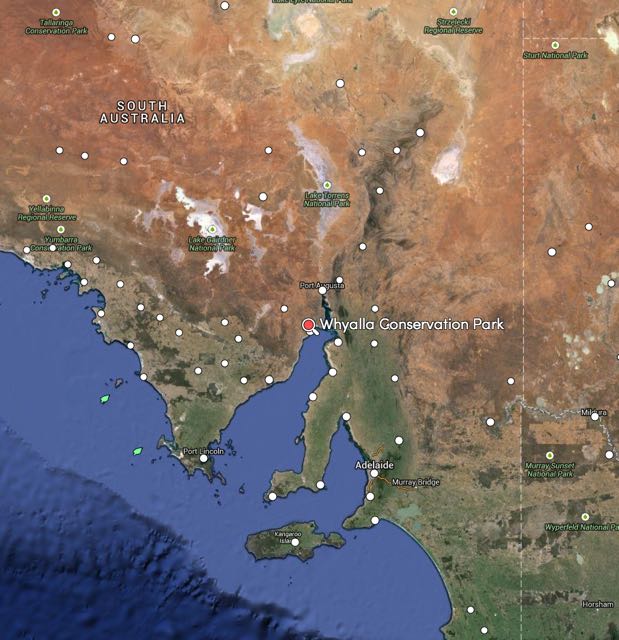
Our first activation for Saturday, 27th December, 2014, was the Whyalla Conservation Park. We had bid farewell to Marija’s mum, brother and family, and were enroute to Melrose in the southern Flinders Ranges, for a one night stay. The Whyalla Conservation Park is located 10 km north of Whyalla off the Lincoln Highway, just passed the Port Bonython turn off.
Map courtesy of mapcarta.com
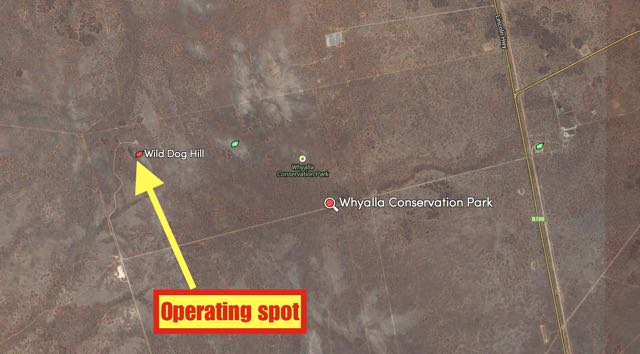
The last time (July 2013) I activated this park, we set up just inside the eastern boundary off the Lincoln Highway.
So, this time, Marija and I decided to enter the park off Lincoln Highway, but travel along Wild Dog Hill Road for a distance of about 8 km, until we reached the impressive Wild Dog Hill. It was here that we set up the gear, using the already provided concrete table and bench as the ‘shack’.
map courtesy of mapcarta
I had only just started working stations when Mark VK5QI arrived. Mark and I had corresponded via email and on air, about catching up in the park. The band conditions on 40m were very poor, with lots of QSB. The normal hoards of park hunters were not there on this occasion. My first contact was with Les VK5KLV in nearby Port Augusta with a very strong 5/9 signal. This was followed by Larry VK5LY in The Riverland, and then Amanda VK3FQSO.
Mark and I alternated on the radio. Whilst Mark was making contacts, I was admiring the view. Although Wild Dog Hill does not qualify for SOTA, as it does not have the required prominence, it is still very impressive and offers spectacular views of the surrounding outback countryside.
This slideshow requires JavaScript.
Mark and I were lucky enough to be called by Ben VK5TX, just as we were about to pack up. Ben was on the top of Mount Gawler, VK5/ SE-013 (5/7 both ways).
Despite the conditions being rather average, we also managed to work a couple of mobile stations. The first being Tim VK3AV who was mobile at Portland in western Victoria (5/8 sent and 5/6 received), and Matt Vk5ZM who was mobile at Tintinarra in south eastern South Australia (5/7 sent and 5/3 received).
So after one hour in the park, I had a total of about 20 QSO’s in the log from VK3 & VK5, whilst Mark had about the same number of QSOs.
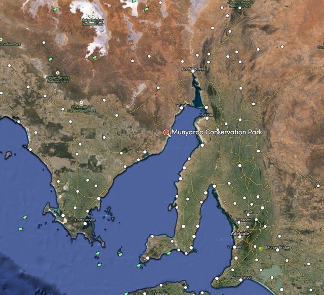
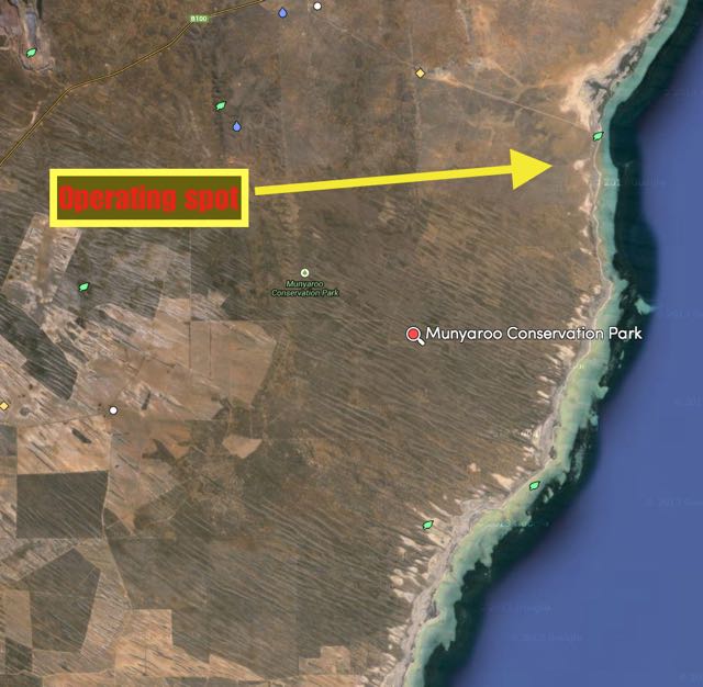
On Christmas morning, my wife Marija and I travelled to Whyalla in the ‘Iron Triangle’ north of Adelaide, to spend Christmas with family and friends. And on Friday afternoon, 26th December 2014, with the formal Christmas festivities over, and an additional 5 kg added to my waistline, Marija and I went for a drive south of Whyalla to the Munyaroo Conservation Park (CP).
Firstly, where is Whyalla? Well, Whyalla is located about 385 km north of Adelaide, via Port Augusta. It is located on the eastern side of the Eyre Peninsula, with its shores on the Spencer Gulf. It was first founded in 1901 and was known as Hummock’s Hill. Then in April 1920, it was proclaimed as Whyalla. The town is known as the ‘Steel City’ due to its integrated steel works and ship building heritage. The Munyaroo Conservation Park is situated about 45 km south of Whyalla, on the way to the seaside town of Cowell.
Map courtesy of mapcarta.com
Munyaroo Conservation Park is 123 km2 and was proclaimed in 1977 with the purpose of conserving mallee and saltbush between agricultural and pastoral properties, and mangrove and samphire communities along the coastal fringe. Being being gazetted as a park, the area was used for grazing, and a small coastal strip was cropped. The ruins of farm dwellings and implements can be found in the park.
Now, don’t be put off. It isn’t easy to find roads on many maps which show access to this park. But, access is gained via Moonabie Station. Again, don’t be put off by the ‘Private property’ signs. You can access the park via Moonabie. But, PLEASE, shut all the gates that you pass through. The road takes you all the way down to the park and Muminnie Beach, where there are a number of shacks.
Vegetation in the park includes low open woodland of western myall and false sandalwood, over a shrubland of bluebush and bladder saltbush. Other vegetation includes an open scrubland of gilja, yorrell and red mallee over bluebush, dryland tea tree porcupine grass, candlebush and twin leaf on the dunes. In the northern area of the park grow native peach trees, native cypress pines, weeping pittosporum and western myall.
The park is home to a large variety of birdlife including Emus, Malleefowl, Stubble Quail, Wedge Tailed eagles, Cormorants, Oystercatchers, and Rainbow Bee eaters. A large variety of native animals are also found in the park including Red Kangaroos, and Sandhill Dunnarts.
After travelling south along the Lincoln Highway towards Cowell for about 45 km, we turned left onto a dirt track. There is a sign here indicating ‘Moonabie Station’. You will shortly thereafter come to an open gate at this location, with a cattle gird. The fence has a sign on it stating ‘Moonabie Private Property’. Follow this road to the east, towards the ocean. You will travel through a couple of closed, but iunlocked gates. You will then reach another gate which has a sign for ‘Mullaquana Station’. A number of km down this dirt track you will reach Muminnie Beach. On your way, you will clearly see the scrub of Munyaroo CP on your right.
map courtesy of mapcarta.com
Marija and I found a nice quiet little spot, on a 4WD track amongst the scrub and set up the gear. I ran my new Yaesu FT-857d at 40 watts for this activation. Prior to calling CQ, I had a quick look around the 40m band and found Joe VK3YSP in conversation with Tim VK3MTB. Joe was on his Christmas/New Year road trip, and was portable in the Warby Ovens National Park, north west of Wangaratta. I waited until Joe had finished his QSO and gave him a call. Joe had a beautiful 5/9 signal coming into Munyaroo. I also spoke with Joe’s wife, Julie VK3FOWL. Joe and Julie are regular park activators and hunters. Joe was kind enough to allow me to have a chat with Tim VK3MTB, who although a little weaker, was still a good 5/7 signal all the way to the Eyre Peninsula.
I then QSY’d up to 7.105 and called CQ. My first taker was Mark VK5QI who was portable in Whyalla, on holidays with family for Christmas. As expected, Mark was making the radio jump off the table. This was followed by park regulars, Greg VK5GJ at Meadows in the Adelaide Hills, and Nev VK5WG at Crystal Brook in the Mid North of South Australia. This was followed by a call from Bob VK5FO who was portable in the Morgan Conservation Park in The Riverland. Again, Bob was a terrific 5/9 to the west coast. I know that Bob specifically stuck around so that we could get a park to park contact. Thanks a lot Bob.
About half a dozen contacts later, I spoke with Peter VK3YE who was portable at Chelsae Beach, near the Pier. Peter was running QRP, just 5 watts, but was a very nice strong 5/8 signal. My only other QRP contacts were with Hans VK5YX in the southern suburbs of Adelaide, running QRP from his MFJ transceiver (5/9 both ways), and Wolf VK5WF running 4 watts from his home brew QRP transciver (5/9 both ways)
This slideshow requires JavaScript.
I went on to work a further 11 VK5 stations, and then to my surprise, I received a call from Rob VK4FFAB, who was portable in the Glass House Mountains National Park, between Brisbane and the Sunshine Coast. And wow, did Rob have a great signal, 5/6 to Munyaroo. Rob is newly licenced and has really embraced the parks activities and the Summits on the Air (SOTA) program. He is a regular VKFF Activator and Hunter.
After a little over an hour in Munyaroo CP, I had a total of 29 contacts in the log from VK3, VK4, & VK5.
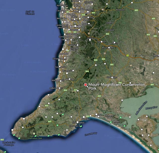
This afternoon I travelled to the Mount Magnificent Conservation Park (CP), which is about 8km north east of the town of Mount Compass, on the beautiful Fleurieu Peninsula, about 58 km south of Adelaide. This is a veery scenic drive from my home qth at Mount Barker, through the towns of Echunga, Meadows, and then on to Prospect Hill.
Map courtesy of mapcarta.com
I last activated this park in July, 2013, so today’s activation was another 1 point for me for the VK5 National and Conservation Parks Award. Here is a link to a post re my previous activation…..
Mount Magnificent CP was established in 1972, and is about 90 hectares in size. It protects a small area of remnant bushland. The major feature of the park is the 380 metre high Mount Magnificent, which sadly does not qualify for the Summits on the Air (SOTA) program), as it does not have the required ‘prominence’. Despite this, there are excellent views from the top. The famous Heysen trail passes through this park and links the nearby Finnis Conservation Park and the Kyeema Conservation Park to the north west.
The park is full of a variety of native wildlfie, including Western Grey kangaroos. And there were plenty of these to be seen.
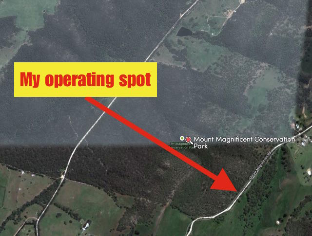
I set up on the eastern side of the park, on the western side of Mount Magnificent Road. I was not all that far from the south eastern corner of the park. Part of the fenceline here had collapsed from the weight of falling branches from the gum trees, so access to the park was very easy. I set up my fold up table and deck chair, about 5 metres in from the boundary fence.
Map courtesy of mapcarta.com
Prior to calling CQ I had a quick tune around the 40m band and I found Paul VK1ATP portable on SOTA peak Mount Majura, VK1/ AC-034, calling CQ on his own on 7.090 (5/7 both ways). That was a nice way to start the activation for me.
I then went up to 7.095 and starting calling CQ and this was immediately responded to by Arno VK5ZAR, and then Les VK5KLV in Port Augusta. Les is becoming a real regular park hunter now, which is great to see. I was then called by Stuart VK5STU who was portable in the Sandy Creek Conservation Park. Stuart had a very strong 5/9 signal, and it was great to be able to get a ‘park to park’ contact. Mick VK3FAFK from Stawell then called in and he was kind enough to place me on the parksnpeaks site.
A few QSOs later I was called by Andrew VK1NAM/3 who was portable on Arthurs Seat, VK3/ VC-031. And then a little further down the log I was called by John VK5BJE who was portable in the Greater Bendigo National Park, which qualifies for the Keith Roget Memorial National Parks Award (KRMNPA) and also qualifies for the World Wide Flora Fauna (WWFF) program. Greater Bendigo NP is VKFF-623.
After working a total of 22 stations on 40m SSB, I lowered the squid pole and removed the links and headed up to 20m. I called CQ on 14.205 and this was answered by Jeremy VK4EVE, with a strong 5/9 signal. Sadly, a Japanese station moved in on 14.206 and that was the end of that. I tuned across the band and found Juha EA8/OH1LEG who was calling CQ. I gave Juha a call, and to my surprise, he responded. I only received a 5/3 signal report from Juha, but I was very pleased that I was able to make it to the Canary Islands. I kept tuning across the band and then worked Lauro IK4GRO (5/8 sent and 5/5 received).
I headed back to 40m and tuned across the band and found W1AW/KH6 calling CQ on 7.183. He was not busy so I gave him a call. After a number of attempts with my call sign, we made a valid contact. The SOTA Goat app on my iphone bleated and I saw that there was a spot for Andrew VK3JBL/6. SO I headed back up to 20m, and although it was a bit of a struggle, I was able to make contact with Andrew (3/4 sent due to the static crashed and 4/5 received). I haven’t worked that many VK6 summits, so I was very pleased to make contact with Andrew.
This slideshow requires JavaScript.
I went on to work Orlando, EA8CCQ, in the Canary Islands. orlando was using a rotary dipole, and we were able to have a comfortable QSO (5/9 sent and 5/5 received).
It was starting to get a bit cool and the local time was just after 7.00 p.m. so I decided to pack up and head home. As it was, it was a very slow drive, as the roads were covered in kangaroos.
After 2 hours in the park I had a total of 28 QSO’s in the log.
The following stations were worked:-
Paul VK1ATP/p (SOTA)
Arno VK5ZAR
Les VK5KLV
Stuart VK5STU/p (park to park)
Mick VK3FAFK
Nev VK5WG
Peter VK3TKK
Andrew VK1NAM/3 (SOTA)
Matt VK1MA
Hans VK5YX
Tom VK5EE
Nick VK3ANL
Andrew VK3ARR
Grant VK2LX
Brian VK5FMID
John VK5DJ
John VK5BKE/3 (KRMNPA & WWFF)
Robin VK5TN
John VK5FTCT
Peter VK5NAQ
Richard VK5ZRY
David VK5HYZ
W1AW/KH6
The following stations were worked on 20m SSB:-
Jeremy VK4EVE
Juha EA8/OH1LEG
Lauro IK4GRO
VK3JBL/6 (SOTA)
Orlando EA8CCQ
References.
Department of Water, Environment and Natural Resources, ‘Parks of the Fleurieu Peninusla’, 2011.
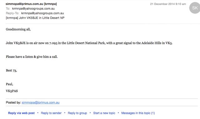
This morning, I received an SMS message from John VK5BJE advising me that he was on air in the Little Desert National Park. So in the throws of making my coffee, I headed to the radio shack and there was John on 7.095 with a great 5/9 signal from western Victoria.
John was keen to get as many contacts as possible for the World Wide Flora Fauna (WWFF) program, so I set about trying to alert as many other amateurs as I could to John’s presence on the band. I kept listening, and it was really pleasing to hear John end up with a large pile up, with many of the stations I had alerted either via SMS, email, etc, giving him a call.
I have mentioned it before here on my WordPress site,
and during various presentations I’ve delivered, but I thought I would mention this again.
PLEASE, don’t become a black hole, and keep the contact to yourself.
Remember, that many of the National Park activators are seeking the required 44 QSOs for the WWFF global award program. So the more calls they get, the better.
There are currently no phone apps similar to SOTA Goat or Rucksack radio, for park activations. So park activators are relying on the goodwill of park hunters to let other amateurs know that they are in a park.
So, what can you do to let others know that a park activator is on a particular frequency? The answer is quite a bit.
SMS message.
Consider setting up an SMS group on your mobile telephone. A few amateurs are doing this, and it works extremely well. If you work a park activator, send an SMS to your group, advising your mates of your contact, so that they too, can hopefully make contact with the park activator.
DX cluster
A DX Cluster is in essence a “chatroom” or node into which amateur DX hunters can post information about DX either worked or heard. Physically, it is a central computer that collects, stores and disseminates information that hams send to it. There are thousands of nodes around the world, connected together via the internet or radio.
Here is a link to the recent presentation given by Brian VK5BC at the Welcome to amateur radio symposium…..
parksnpeaks
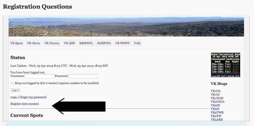
The parksnpeaks site is a terrific spotting and alert facility created by Allen VK3HRA. The parksnpeaks site is FREE to join. Just simply register a new account.
The parksnpeaks site has some excellent features. It can be used to add VK activity including QRP operation, National Parks, Conservation Parks, or portable operation in general, whilst SOTA spots are added directly via SOTAWatch.
The parksnpeaks site offers:-
‘spotting’ facilities
and
‘alert’ facilities.
‘Spotting’ is where you can add details of stations you have worked or heard. This allows you to share information with other amateurs.
‘Alerting’ is where you can add details of your proposed activations, so people can see what your future plans are.
email
Send an email to your mates. Creating an email group is easy.
If you are using Gmail…..
To create a contact group:
Click Gmail at the top-left corner of your Gmail page, then choose Contacts.
Select contacts that you want to add to a group, click the Groups button. , then Create new.
Enter the name of the group.
Click OK.
If you use another email platform, there are plenty of tips on the internet regarding creating groups.
Yahoo groups
Place a post on the World Wide Flora Fauna or VK5 Parks Yahoo groups.
Send a message out to other amateurs on your local repeater. I know that many of the amateurs in the South East of South Australia, are doing this, and it works well.
WWFF Forum
The World Wide Flora & Fauna program (WWFF) does not have a spotting & alert facility like SOTAwatch. But Activators are encouraged to place their intended activations on the WWFF Forum. A huge number of European amateurs read the Forum and will be able to see your intentions.
So, as you can see there is a lot you can do. So please, after working a park activator, don’t just sit back and do nothing. Consider sharing your contact with other like minded amateurs. You are not only benefiting the other park hunters, but also the activator themselves.
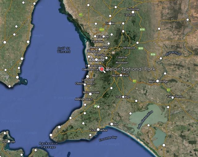
Yesterday (Saturday 20th December, 2014) I activated the Belair National Park (NP), VKFF-022, in the Mount Lofty Ranges ‘Adelaide Hills’. I had already activated Belair NP earlier in the year, so there were no VK5 Park Award points up for grabs. And I had already passed the 44 QSO threshold for Belair NP in the World Wide Flora and Fauna (WWFF) program. But my real motivation, was to try out my new radio. My beautiful wife Marija (and yes I am constantly reminded I am ‘boxing above my weight’) and my lovely daughter Olivia, purchased a Yaesu FT-857d for me, and gave it to me as an early Christmas present and early 50th birthday present. I turn 50 on the 5th January. So it was off to Belair for me, just a 15 minute drive to the west from home.
I set up just inside Gate 1 off Sheaok Road, at Crafers. This is on the northern side of the park. This gate was locked, however there is no restriction to access to the park at this point. There is a walking track here, Wilyawa Track. But to gain access to it, you need to either jump the fence, which has barbed wire, or jump the padlocked gate. Why DEWNR do not have a pedestrian access point here I do not know? Anyway, I got all the gear from the 4WD and then jumped the fence and walked a short distance down the track, where I set up my station, under the shade of some gum trees, as it was a warm 30 deg C day.
Map courtesy of mapcarta.com
I started off on my nominated frequency of 7.095. I had posted on the VK5 Parks Yahoo group and the WWFF Australia Yahoo group that I would be on air at 0600 UTC on 7.095. I was about 15 minutes late, but still did not have to call CQ. I asked if the frequency was in use and this was responded to by Les VK5KLV at Port Augusta with a beautiful 5/9 signal. Les gave me a 5/9 in return, and it seemed the band was in very good shape. It was certainly very quiet. There was no man made noise on the band due to the remote location of the park, and the QRN (static crashes) that have been present over the past few weeks were noticably absent. My second caller of the day was Adam VK2YK who was a good 5/8. Adam was struggling with me a little bit due to QSB, but gave me a 5/4 signal report. This was followed by Mal VK5MJ in The Riverland in South Australia, who was 5/9 plus. David VK5KC then called me, using just 1 watt, and was a very nice 5/8 signal. I had already caught up with David earlier in the day for a coffee.
I went on to work a further 20 stations in VK1, VK3, and VK5. A few of those stations were operating QRP. The first QRP caller was Peter VK3TKK who was running just 5 watts. Peter’s signal was only signal strength 3, but due to the low noise floor, I was able to receive him perfectly. This was followed by Andrew VK1NAM mobile in VK3, in the outer eastern suburbs of Melbourne. Andrew was running just 2.5 watts from his FT-817 in the car, but nether less had a great 5/7 signal. Tom VK5FTRG then called in from the South East of South Australia, running just 5 watts, with a nice 5/9 signal. My final QRP caller was regular QRP operator, Ian VK5IS, again running 5 watts. Ian had a beautiful 5/9 signal coming in from the Mid North of South Australia.
I also worked a few mobile stations. Other than Andrew mentioned above, I also spoke with Greg VK5ZGY who was mobile in the South East of South Australia, with a good strong 5/7 signal. Greg had co pilot and wife, Gabbie, alongside of him. I then spoke with Ian VK6PXF who was mobile in VK5 at Lonsdale, south of Adelaide. Ian has started activating National Parks, and has sent me quite a few of his logs for upload to the WWFF Log Search facility. And lastly I was called by Robin VK5TN who was mobile at Hahndorf in the Adelaide Hills.
But to make my day, I was called by Richard VK5ZRY, who had decided to head out to the Ramsay Way Conservation Park. The park is/was located on Richard’s property on the Yorke Peninsula. Richard was trying out his new Yaesu FT-817 and had a magnificent 5/9 signal coming across the Gulf St Vincent to Belair.
This slideshow requires JavaScript.
I left the frequency to Richard, and lowered the squid pole and removed the links in the dipole, so I could operate on 20m. However, I was disapointed when I tuned across 20m, to hear only very weak signals coming in from Europe. I found that my nominated frequency of 14.244 was clear, so I put out about 8 CQ calls but had no takers. Rather disapointed, I tuned across the 20m band and could hear three stations coming in from Spain. However, their signals were well down compared to normal conditions. I also heard Jason ZL3JAS, working long path into Europe. However, all the European stations he was making contact with, were very weak to me.
So I headed back to 40m. Prior to calling CQ again, I tuned across the 40m band and I could hear quite a few Europeans & stations from the United Kingdom coming through, including Javier, EA7GAK on 7.178 who was working into the USA. I gave Javier a few calls, but sadly he could not hear me. I also heard W1AW/3 on 7.161 working into Europe. I also called him, but again my 40 watts just wasn’t making the grade. So I went back to 7.095 and called CQ again, and this was responded to by Nic VK5ZAT who was portable at Carrackalinga on the Fleurieu Peninsula. I had worked Nic a little earlier, prior to QSYing to 20m. He had been having problems with a high VSWR on his dipole. And this time, his signal had dropped down a good 2 S points. I was then called by Mick VK3FAFK in Stawell in western Victoria, with a beautiful 5/9 signal. And this was followed by Andrew VK5UR mobile in VK2, about 100 km south of Parkes. I had a lengthy chat with Andrew and his signal always remained around the S9. Andrew was running an IC7100 and a roof mounted whip antenna. My last contact on 40m was with Adam VK2YK who had called in again, as conditions had improved. I was now 5/9 with Adam, and he was 5/9 plus. I worked a further 13 stations from VK2, VK3, VK4, & VK5.
My curiosity had got the better of me, so I again lowered the squid pole and removed the links in the dipole, and again tuned to 20m. I was hoping that the band had improved. But it was getting a little late, approaching 8.00 p.m. Again, I could hear some weak Europeans, who were certainly not strong enough for me to try to make contact with. I managed just 1 DX contact and that was with Michio, 7L4LKK, who was a strong 5/9 to Belair.
So after a number of hours in the park, I had a total of 41 contacts in the log.