South East Radio Group Convention

After my activation at Penambol Conservation Park I headed back into Mount Gambier and attended the South East Radio Group (SERG) Convention at the scout hall at Margaret Street.

I met up with a number of the SERG guys including Col VK5HCF, Tony VK5ZAI, Tim VK5AV, and John VK5DJ.

I set up a display relating to the VK5 National and Conservation Parks Award and the World Wide Flora Fauna (WWFF) program.  On display I had a number of award certificates, my Yaesu FT-817nd, my Yaesu FT-857d, 44 amp hour power pack, LiFePo batteries, SLAB batteries, bothy bag, handheld GPS devices, solar panels, & antennas.  I also had a number of promotional handouts.

DSC_0147

There were a number of hams in attendance from VK5 and VK3.  This included a number of traders, including Ross from Strictly Ham.

This is the 51st year of the SERG Convention and the National Fox Hunting Championships.  For more information, have a look at…..

http://serg.mountgambier.org/

This slideshow requires JavaScript.

Penambol Conservation Park VKFF-802

My one and only park activation for Saturday 6th June, 2015, was the Penambol Conservation Park, which is situated about 22 km south east of Mount Gambier, and 450 km south east of Adelaide.  This was another early start from the motel, and after a detour to the ‘Golden Arches’ McDonalds for a quick breakfast, I headed out of Mount Gambier along the Glenelg River Road, towards the Victorian border.

This was to be another unique park for me for both the VK5 National & Conservation Parks Award and the World Wide Flora Fauna (WWFF) program.

Screenshot 2015-06-11 22.44.51

Above:- Map showing the location of the park.  Map courtesy of mapcarta.com

I continued south east along the Glenelg River Road, through the areas of Square Mile and Caveton.  I turned left into Carba Road, which is a narrow little dirt road.  I passed a number of farmhouses and then pine forest on both my right and left.  I located the park on the corner of Carba Road and Honeysuckle Road.  The park sign was quite visible amongst the scrub.

Penambol Conservation Park adjoins the Warrenga Native Forest Reserve and is 179 hectares in size.  The park was acquired for conservation purposes in 1984 and was constituted in December 1993.  It conserves an important area of remnant vegetation, formerly known as Herpst’s Scrub.  It contains several unique geological features, including Caroline SInkhole, which has archaeological significance.

The park has a Wombat Walk, which provides numerous opportunities to view wombats, with dozen of wombat burrows evident in the area.  I didn’t even know that wombats were found in this area.  I thought it was too cold.

The park also contains South Australia’s first butterfly monitoring sites, enabling visitors to the park to experience and learn about local butterflies, such as the Ochre Butterfly and Orange species Butterfly.

The park contains a large amount of native wildlife including the Eastern Grey Kangaroo, Red-necked Wallaby, Ringtail Possum, Echidna, Wombat, Yellow Bellied gliders, and Bush Rat.  The threatened Gang Gang Cockatoo and Red Tailed Black Cockatoo have also been sighted in the park.

Screenshot 2015-06-11 22.54.12

Above:- Map showing my operating spot.  Map courtesy of mapcarta.com

I was set up and ready to go by 2250 UTC (8.20 a.m.) and started calling CQ on 7.095.  David VK5NQP was my first caller with a great 5/9 signal.  This was followed by Mick VK3PMG in Stawell who was also 5/9, and then Barry VK5KBJ.

I worked a number of QRP stations including Adrian VK5FANA running 5 watts, Paul VK3DBP running 5 watts, Amanda running 500 milliwatts (5/8 sent and 5/9 received), Mark VK7MK running 2.5 watts (5/8 sent and 5/5 received), Ian VK5IS running 5 watts, Mike VK3XL also running 5 watts, and Trevor VK3FPY/5 running 5 watts with his home made vertical.

I also spoke with Mark VK5LO and and Paul VK1AT/3, both of whom were operating with home brew transceivers.

Tony VK3VTH also called in from the Cape Nelson State Park VKFF-754.  It was great to get another new VKFF reference in the log.

My final contact on 40m was with Peter VK3YE who was portable on the beach at Chelsea, running an FT817 on 5 watts and a home brew antenna (5/9 both ways).

I did call CQ numerous times on 14.310, but unfortunately there were no takers.  Sadly I couldn’t alert anyone that I was there via parksnpeaks, as there was no mobile coverage in the park.

This slideshow requires JavaScript.

After 90 minutes in the park, I had a total of 51 contacts in the log.  I was very pleased.  I needed 44 contacts to qualify the park for the WWFF program.  This was another unique VKFF activation to add to my list.

The following stations were worked:-

  1. VK5NQP
  2. VK3PMG
  3. VK5KBJ
  4. VK5JK
  5. VK3PF
  6. VK5FANA
  7. VK5ZAR
  8. VK3OF
  9. VK5PJ/m
  10. VK3DBP
  11. VK5KLV
  12. VK6RZ
  13. VK5LO
  14. VK5TW
  15. VK5FTVR
  16. VK3FQSO
  17. VK3NBL
  18. VK3TKK/m
  19. VK7MK
  20. VK5IS
  21. VK3HRA
  22. VK2BBQ/p
  23. VK3BFR
  24. VK2IO/m
  25. VK7NWT
  26. VK5FMID
  27. VK2YW
  28. VK5HEL
  29. VK3FSPG
  30. VK3FDES/m
  31. VK2NP
  32. VK3XL
  33. VK4AAC/5 (Kangaroo Island)
  34. VK3FPY/5
  35. VK5AKH/m
  36. VK1AT/3
  37. VK3AV
  38. VK5BJE (on either side of the UTC rollover)
  39. VK5ZGY/m
  40. VK3VTH/p (Cape Nelson State Park VKFF-754)
  41. VK4RZ
  42. VK5GM
  43. VK6FN
  44. VK2ATZ
  45. VK5KC
  46. VK3FPBI
  47. VK3KKP
  48. VK3HAK
  49. VK7LTD
  50. VK2SRT
  51. VK3YE/p (Chelsea Beach)

References.

Department of Environment and Natural Resources, 1994, Small Inland Parks of the South East Management Plan.

Department of Environment and Natural Resources, 2010, Penambol Conservation Park.

Hacks Lagoon Conservation Park

My final activation for Friday 5th June, 2015 was the Hacks Lagoon Conservation Park, which is situated midway between Adelaide and Melbourne.

Screenshot 2015-06-11 22.12.40

Above:- Map showing the location of the park.  Map courtesy of mapcarta.com

Hacks Lagoon Conservation Park adjoins the basin of the adjacent Bool Lagoon Game Reserve, which is one of the largest and most diverse freshwater lagoon systems in southern Australia.  The seasonal wetland areas of Bool Lagoon and Hacks Lagoon are home to a wide range of wildlife and provides essential drought refuge for numerous rare and endangered bird species.  In fact, over 150 species of birds visit the area.  A number of birds visit the park during Summer, including Sharp-tailed Sandpipers, who fly thousands of kms to be at Bool and Hacks Lagoons.  Brolgas are perhaps the most spectacular of all of the birds that can be found here.

Screenshot 2015-06-11 22.37.38

Above:- Map showing Bool and Hacks Lagoons.  Image courtesy of DEWNR

The area is recognised under the Ramsar Convention on Wetlands as a Wetland of International Importance.  It is protected under the Japan/Australia and China/Australia Migratory Bird Agreement due to the importance of the area as a summer refuge for migratory wading birds.

Screenshot 2015-06-11 22.13.20

Above:- Map showing my operating spot.  Map courtesy of mapcarta.com

The 40m band was very busy below 7.100 so I found 7.115 clear and started calling CQ.  My first taker was John VK5BJE, followed by Col VK5HCF in Mount Gambier, and then Jim VK5TR.  The band started off very good, with great signals from eastern Australia.  But this didn’t last long.  The band dropped out very quickly to VK3.  However, the band remained open to southern Australia and the remainder of eastern Australia.

I worked a number of QRP stations including Gerard VK2JNG who was portable, Greg VK5GJ again running just 4 watts, Peter VK3PF running 5 watts, Mark VK7MK running 2.5 watts, Andrew VK1NAM running 5 watts, Alan VK2AJG running 5 watts, Nev VK5WG running 5 watts, and Adrian on the Yorke Peninsula running 5 watts.

This slideshow requires JavaScript.

I remained in the park until just before 0800 UTC (5.30 p.m.) and watched a magnificent sunset.  I managed a total of 32 contacts on 40m SSB into VK1, VK2, VK3, VK4, VK5, and VK7,

The following stations were worked:-

  1. VK5BJE
  2. VK5HCF
  3. VK5TR
  4. VK3AXF
  5. VK3FEUG
  6. VK3AV
  7. VK4AAC/5 (Kangaroo Island)
  8. VK5JK
  9. VK5LSB
  10. VK2JNG/p
  11. VK5GJ
  12. VK3PF
  13. VK3DBP
  14. VK7MK
  15. VK1NAM
  16. VK2AJG
  17. VK3OHM
  18. VK5ZAR
  19. VK5NQP
  20. VK2NP
  21. VK3FBI
  22. VK5KLV
  23. VK3FQSO
  24. VK3OF
  25. VK5KPR
  26. VK5WG
  27. VK7LTD
  28. VK4FBMW
  29. VK4FAAS
  30. VK5FANA
  31. VK7VEK
  32. VK4RZ


References.

Department of Environment and Natural Resources, 2010, Bool Lagoon Game Reserve and Hacks Lagoon Conservation Park brochure.

National Parks South Australia, 2015, <http://www.environment.sa.gov.au/parks/Find_a_Park/Browse_by_region/Limestone_Coast/Bool_Lagoon_Hacks_Lagoon&gt;, viewed 11th June 105.

Big Heath Conservation Park VKFF-792

After leaving Mary Seymour Conservation Park, I travelled a short distance to my next park activation location at the Big Heath Conservation Park, which is situated about 20 km south of Naracoorte.  This was another unique park for me for the VK5 National & Conservation Parks Award and a unique park for the World Wide Flora Fauna (WWFF) program, so I was hoping to get my 44 contacts.  Big Heath was only just recently added to the WWFF program.

Screenshot 2015-06-11 21.22.34

Above:- Map showing the location of the park.  Map courtesy of mapcarta.com

Big Heath Conservation Park was constituted back in 1964 and covers an area of 2,351 hectares.  In an extra 100 hectares of land was added to the park.  When this land was added, Department of Environment Water and Natural Resources (DEWNR) CEO stated:-

‘Big Heath Conservation Park is situated in an area of high national and state priority for conservation, and protects remnant wet heath land vegetation in a regionally threatened plant community’.

The park contains a diversity of vegetation types.  It is certainly a very attractive park.  In the higher areas of the north eastern corner of the park, there is a Eucalypt woodland with a sparse understorey.  In the north western end of the park you can find a low woodland of Brown Stringybark, Pink Gum, and Desert Banksia.  A number of limestone outcrops located throughout the park, support Manna Gum, South Australian Blue Gum and Pink Gum woodlands.  In the south eastern corner of the park, River Red Gums of varying age and densisty proudly stand.  A dense heath of Mallee Honey Myrtle, Yellow Hakea, and Prickly Tea Tree is also found.  As elevation increases in the park, there are corresponding changes to the heath vegetation associations, with Broombrush, Grass Tree and Dwarf Sheaok occurring.

A large amount of native wildlife can be found in the park including the threatened species, Little Pygmy Possum.

Screenshot 2015-06-11 21.26.39

Above: Map showing the borders of the park.  Map courtesy of google maps.

I set up in the south eastern corner of the park, after following Coles-Kilanoola Road into the park, passed the vineyards.  There was a nice cleared area at this location with plenty of room for me to run out the linked dipole.

Screenshot 2015-06-11 21.28.12

Above:- My operating spot.  Map courtesy of mapcarta.com

Again, I started off calling CQ on 7.095 and first cab off the rank was Greg VK5GJ at Meadows, running his normal QRP 4 watts with a nice 5/7 signal.  This was followed by Jim VK1AT/3 who is being a regular park hunter.  Next up was Rob VK4AAC/5 portable on Kangaroo Island, and then two regular park hunters, Arno VK5ZAR and Mick VK3PMG.

Things were travelling along well, and I was on my way to 44 contacts.  I had a steady flow of callers from all over Australia.  As I normally do, I took a break from the hunters from home, to listen out for mobiles and portables.  This resulted in a large number of mobile stations calling in, including husband and wife team Joe VK3YSP and Julie VK3FOWL, Eugene VK5ZA mobile at Auburn in the Clare Valley, Greg VK5ZGY, Mark VK5QI mobile at Blanchetown in the Riverland, Simon VK3SMC mobile in the Toolangi State Forest (4WDing), Peter VK5KX mobile at Blanchetown, Matt VK5ZM, Peter VK3TBN mobile at Bundoora, Chris VK2SR mobile in the ACT, and Tom VK5FTRG.  I was also called by Kerry VK4FKDP portable near the Condamine River .

This slideshow requires JavaScript.

At 0550 UTC (3.20 p.m. SA local time) I QSYd from 7.095 up to 7.105, so that I did not cause any QRM to the Kandos Net which operates at 0600 UTC on 7.093.  I worked a further 9 stations in VK3, VK4, & VK5 on 7.105.

After an hour in the park, I had 45 contacts in the log, thus qualifying the park for WWFF.  I was tempted to have a go on 20m but it was getting a little late (4.40 p.m. SA local time) and I still wanted to get to Hacks Lagoon.  I was cognisant that if I called CQ on 20m from a VKFF park, and the Europeans found me, it would be very hard to get out of Big Heath.  So I packed up my gear and headed off for another unique park, Hacks Lagoon.

The following stations were worked:-

  1. VK5GJ
  2. VK1AT/3
  3. VK4AAC/5 (Kangaroo Island)
  4. VK5ZAR
  5. VK3PMG
  6. VK3OHM
  7. VK3NBV
  8. VK3NBL
  9. VK3DBP
  10. VK3FQSO
  11. VK5JK
  12. VK3BHR
  13. VK3PF
  14. VK5HCF
  15. VK4RZ
  16. VK2NP
  17. VK3YSP/m
  18. VK5FANA
  19. VK5NRG
  20. VK3FOWL/m
  21. VK5ZA/m
  22. VK5ZGY/m
  23. VK5QI/m
  24. VK3SMC/m
  25. VK5KX/m
  26. VK5ZMm
  27. VK4FKDB/p
  28. VK3TBN/m
  29. VK2SR/mobile1
  30. VK5AW
  31. VK5FMID
  32. VK5NIG
  33. VK3OF
  34. VK3MEK
  35. VK5FCHM
  36. VK5BJE
  37. VK3TJK
  38. VK5KLV
  39. VK4GSF
  40. VK3AIG
  41. VK5FTRG/m
  42. VK7CC
  43. VK3MCK
  44. VK3FEUG
  45. VK5NQP

References.

Natural Resources Group, Department of Environment and Natural Resources, 1994, Small Inland Parks of the South East Management Plan.

Department of Environment Water and Natural Resources, 2015, <http://www.environment.sa.gov.au/Home/Full_newsevents_listing/News_Events_Listing/110113-Three_new_parks&gt;, viewed 11th June 2015

Mary Seymour Conservation Park

My next planned activation of the day was the Big Heath Conservation Park.  However after leaving Vivigani Ardune, the GPS took me on a merry drive around the South East and I was not able to access Big Heath.  So I headed for one of my other planned activations, the Mary Seymour Conservation Park.  Another unique park for me.

Mary Seymour Conservation Park is situated about 25 km south of Naracoorte in the South East of South Australia.

Screenshot 2015-06-11 20.18.34

Above: Map showing the location of the park.  Map courtesy of mapcarta.com

The park was constituted in 1980 and covers an area of around 264 hectares.  The western quarter of Mary Seymour consists of a limestone ridge which supports a low open forest of Brown Stringybark and Pink Gum.  The remainder of the park is a complex wetland system with limestone outcrops.

I accessed the park via Bool Lagoon West Road.  I found a clearing amongst the scrub, and I set up my equipment.

Screenshot 2015-06-11 20.18.48

Above:- Map showing my operating spot.  Map courtesy of mapcarta.com

I started calling CQ on 7.093 as Adam VK2YK was operating on 7.098.  My first taker was Amanda VK3FQSO with a lovely 5/9 signal.  This was followed by Marc VK3OHM  and then Rob VK4AAC/5 on Kangaroo Island.  It was 1.30 p.m. SA local time and the 40m band was holding up very well, with nice signals.  I worked a total of 27 stations in the park from VK2, VK3, and VK5.

That included a handful of QRP operators, including Greg VK5GJ running 4 watts (5/7 sent and 5/9 received), and Paul VK3DBP running 5 watts (5/9 both ways).  I also worked a number of mobile stations including Greg VK5ZGY, Peter VK3TKK, Terry VK3BMX using a Famparc whip, Mark VK5QI mobile at Truro, and Peter VK3PF.

I was also fortunate that Adam VK2YK had tracked me down and gave me a call from Hunter Wetlands National Park, VKFF-595.

This slideshow requires JavaScript.

I only remained in the park for 30 minutes, as I still had 2 planned park activations for the day.  But I was very happy, I had 27 contacts in the log.

The following stations were worked on 40m SSB:-

  1. VK3FQSO
  2. VK3OHM
  3. VK4AAC/5 (Kangaroo Island)
  4. VK3PMG
  5. VK5WG/p
  6. VK5HCF
  7. VK5ZAR
  8. VK5KLV
  9. VK5GJ
  10. VK5ZGY/m
  11. VK3TKK/m
  12. VK1AT/3
  13. VK3BMX/m
  14. VK2YK/p (Hunter Wetlands National Park VKFF-595)
  15. VK5QI/m
  16. VK3DBP
  17. VK3PF/m
  18. VK3OF
  19. VK2UH
  20. VK3BHR
  21. VK5JK
  22. VK5BJE
  23. VK5FMID
  24. VK3LPG
  25. VK3FTAD
  26. VK3FARO
  27. VK3FLSS

Vivigani Ardune Conservation Park

After leaving the Fairview Conservation Park, I headed to my next activation, the Vivigani Ardune Conservation Park, situated just north west of the little town of Lucindale.  This was another unique park for me for the VK5 National and Conservation Parks Award.

Screenshot 2015-06-11 19.29.58

After leaving Fairview I travelled back into Lucindale along Fairview Road.  Lucindale is a little town of about 400 people and is situated about 345 km south east of Adelaide.  It is best known for hosting the annual South East Field Days, which attracts over 25,000 visitors each March.

After leaving Lucindale I headed out along the Reedy Cfreek-Lucindale Road, and then turned right into Conricks Road.  The park is about 4 km up Conricks Road on the left hand side (on the western side of the road).  Keep a careful eye out for the park sign with can be located in a paddock which forms part of the park.

On the way to the park I spoke from my mobile, with Alan VK7BO who was on a SOTA peak, The Tump, VK7/ NC-018 (5/9 both ways).  I also spoke with Nigel VK5NIG who was portable on SOTA peak Mount Gawler VK5/ SE-013 in the Mount Lofty Ranges (5/9 both ways).

I was unable to find out a lot about this park, which was proclaimed in 2008.  John VK5BJE and I spoke about the origins of the name on air.  John was my 2nd contact.  We believe it may have Latin ties and means something similar to ‘toil hard’.  But more research will need to go into that.  There is a property called Vivigani just to the south of the park.

Screenshot 2015-06-11 19.30.36

Unfortunately this is another park which required some fence jumping.  So many South Australian parks are locked up by padlocked gates.  This one didn’t have a padlock, but there was a gate which appeared to have not been opened since the medieval times.  On the gate was a sign which read ‘Sanctuary’ which appeared to have been there in time immeorial.  So I jumped the fence to gain access to park.  Be careful of the electric fence!

My first contact in the park was with Nigel VK5NIG who I tracked down after setting up.  Nigel was still on Mount Gawler and was calling CQ on 7.105.  Nigel was a good 5/9 and I’m pleased he was.  I was very saddened to find that I had an S9 noise floor on 40m when I turned on the radio.  I’m suspecting that this was a combination of the electric fence and the power lines which run through the paddock.

After speaking with Nigel I headed down to 7.095 and called CQ and this was answered by a number of the park regulars including John VK5BJE, followed by Les VK5KLV, Tony VK5FTVR and Mick VK3PMG.  Fortunately all of their signals were above the noise floor.  I went on to work a total of 34 stations on 40m in VK2, VK3, VK4, VK5, and VK7.  That included a number of QRP stations including Greg VK5GJ running 5 watts (5/9 both ways), and Peter VK3PF also running just 5 watts (5/7 sent and 5/9 received).

I also worked a few mobile stations which included Rod VK5KFB mobile in the South East, Eugene VK5ZA mobile at Burra in the Mid North, and Dave VK2BDR.

This slideshow requires JavaScript.

When things slowed down on 40m I headed up to 20m.  I called CQ on 14.310 and this was answered by Adam VK2YK who was operating portable in the Hunter Wetlands National Park, VKFF-595 (5/9 both ways).  A nice little bonus.

I would have stayed around a bit longer on 20m, but the rain had hit again, and once again it was a hasty retreat from this park.

The following stations were worked on 40m SSB:-

  1. VK5NIG/p (SOTA Mt Gawler VK5/ SE-013)
  2. VK5BJE
  3. VK5KLV
  4. VK5FTVR
  5. VK3PMG
  6. VK5ZGY
  7. VK5NQP
  8. VK3FQSO
  9. VK3OHM
  10. VK5ZAR
  11. VK5GJ
  12. VK3OF
  13. VK3BHR
  14. VK5KFB/m
  15. VK3UP
  16. VK1AT/3
  17. VK5IS
  18. VK2VEX
  19. VK5ZA/m
  20. VK3PF
  21. VK2BDR/m
  22. VK2NP
  23. VK7RM
  24. VK5VGC
  25. VK5BW
  26. VK3NBL
  27. VK3BWZ
  28. VK5FUZZ
  29. VK4CPS
  30. VK5FADS
  31. VK5FO/p
  32. VK3PRF
  33. VK3TKK
  34. VK7MK

The following station was worked on 20m SSB:-

  1. VK2YK (Hunter Wetlands National Park VKFF-595)


References.

Wikipedia, 2015, <http://en.wikipedia.org/wiki/Lucindale,_South_Australia&gt; viewed 11th June 2015


Fairview Conservation Park

My first planned park activation for Friday morning (5th June 2015) was the Fairview Conservation Park (CP).  This was to be a unique VK5 Park for me for the VK5 National & Conservation Parks Award.  Fairview was the first of 5 planned park activations for the day.  It was an early start from the motel.  I was on the road by 7.00 a.m.

Fairview CP is situated about 17 km north of Lucindale and about 345 km south east of Adelaide.  The park was constituted in 1960 and covers an area of around 1,398 hectares (3,440 acres) so it is quite a large park.  The park contains two semi permanent lagoons which I did not visit.  But I would like to get back to this park and explore it in my 4WD.  According to the park Management Plan there is a picnic area situated between the lagoons which can be reached by a track leading from the north west corner of the park.  But due to the date of this publication, I’m not sure if that still exists.

Screenshot 2015-06-11 18.32.55

Above:- Map showing the location of the park.  Image courtesy of mapcarta.com

The park also has extensive areas of seasonally inundated flats, sandy flats and ridges, and limestone ridges.  The park contains large gums, Stringy Barks, various native grasses, and Banksias.  Other than the native wildlife, deer can also be found in the park.  The rare Red Tailed Black Cockatoo can be found in the park.

Screenshot 2015-06-11 18.48.27

Above: Map from the Management Plan showing the track leading to the picnic area.  Map courtesy of Dept Env Natural Resources (now DEWNR)

I travelled north west out of Mount Gambier along the Riddoch Highway and passed through Naracoorte.  About 5 km out of Naracoorte is Lochaber Lane.  There is a sign here for the park.  I turned left here and continued west on Lochaber Lane for a number of kms, until I reached Woolumbool Road.  A few km up Woolumbool Road, you will see the park on your right on the eastern side of the road.

I found an open gate off Woolumbool Road and pulled into the park.  It was quite a bleak and cold morning, so I hurriedly set up my fold up table, deck chair, and antenna, in the hope to beat any rain.  For this activation I ran my normal portable set up which consists of a Yaesu FT-857d, 40 watts and a 40m/20m linked dipole supported on a 7 metre squid pole.

Screenshot 2015-06-11 18.32.43

Above: Map showing my operating location in the park.  Map courtesy of mapcarta.com

I found that there was a strong Asian station on 7.095 so I headed down a little lower to 7.090 and started calling CQ.  My first taker of the morning was Amanda VK3FQSO and this was followed by Peter VK3TKK who was mobile, then Mark VK7MK, and then Les VK5KLD.  Signals were excellent from all four stations.

I worked a total of 11 stations, until a VK5 planted himself on 7.088 and started calling CQ.  My last contact there was with Gerard VK2IO who was mobile.  So due to the QRM I QSYd up to 7.095 and was followed up by Scott VK7NWT.  I worked a total of 13 stations here before the UTC rollover at 9.30 a.m.  This included a contact with Al VK7AN who was on Flinders Island OC-195 in the Strzelecki National Park, VKFF-469.  A new park for me.  And man, was Al’s signal strong.

I also spoke with Ori who was kind enough to send me some photos via email (see below).

In turn I sent off Ori one of my unique QSL cards for this activation at Fairview (see below).

VK3NRG Fairview Conservation Park

My first taker after the UTC rollover was Mr. Reliable, John VK5BJE in the Adelaide Hills with a very nice 5/9 signal.  And this was followed by another park devotee, Les VK5KLV in Port Augusta.  Les always has a 5/9 plus signal.  My next contact was with Bryce VK3NBI.  I was his first ever contact on 40m (5/9 both ways).

Just one QSO later I spoke with Rod VK5KFB who was mobile at nearby Willalooka, on his way down to Mount Gambier for the South East Radio Group Convention.  I also worked Dave VK2BDR (Dodgey Bodgey Radio) who was also mobile (5/8 sent and 5/7 received).  My last contact on 40m was with Cliff VK2NP.

This slideshow requires JavaScript.

So after working a total of 35 stations on 40m, I lowered the squid pole and removed the links in the antenna and headed off to 20m.  I went to my normal calling frequency of 14.310 and asked if the frequency was in use, and this was answered by Dave VK4DD who told me that he had just started calling CQ from SOTA summit Springbrook Mountain VK4/ SE-011 in the Springbrook National Park VKFF-463.  Now that was very fortuitous to stumble across Dave.

After working Dave I headed down to 14.305 and put out half a dozen CQ calls but had no takers.  Unfortunately I had no mobile phone coverage in the park so I was not able to spot myself on parksnpeaks.  And anyway, it had started to drizzle with rain.  So I hastily packed up the gear and hit the road for my next park, Vivigani Ardune Conservation Park.

I would like to thank Greg VK5ZGY mobile who I worked during this activation, and gave me some good directions on how to get to Vivigani Ardune.

The following stations were worked on 40m SSB:-

  1. VK3FQSO
  2. VK3TKK/m
  3. VK7MK
  4. VK5KLD
  5. VK5FMID
  6. VK3PF
  7. VK3FMLMR/m
  8. VK5FTVR
  9. VK3JW
  10. VK3TJK
  11. VK2IO/m
  12. VK7NWT
  13. VK5FAJH
  14. VK1AT/3
  15. VK3PRF/m
  16. VK5NIG
  17. VK5HEL
  18. VK5JK
  19. VK3NRG
  20. VK7FLI
  21. VK7AN
  22. VK3DBP
  23. VK5ZGY/m
  24. VK1MCK
  25. VK5BJE
  26. VK5KLV
  27. VK3NBI
  28. VK3FACE
  29. VK5KFB/m
  30. VK2SK
  31. VK3OF
  32. VK5FANG
  33. VK2BDR/m
  34. VK2HHA
  35. VK2NP

The following station was worked on 20m SSB:-

  1. VK4DD/p (SOTA VK4/ SE-011 and VKFF-463)


References.

Natural Resources Group, Deaprtment of Environment and Natural Resources, 1994, Small Inland Parks of the South East Management Plan

Naracoorte Caves National Park, VKFF-380

After leaving Christmas Rocks I was hoping to activate Talapar Conservation Park.  However, the GPS led me on a wild goose chase and despite my best efforts I could not get into the park.  This included following an 8km section of very sandy and boggy track which showed on the GPS leading straight into the park.  But by the time I got to the end there was a locked gate and I was still 2 km short.

I was starting to get very frustrated and tired, so I took an easy option and headed back into nearby Naracoorte and activated the Naracoorte Caves National Park, VKFF-380.  This was not a new park for me (I had been there before in June, 2014 – see below), but I knew that it was an easy park to access and there was shelter there from the never ending rain.

https://vk5pas.org/2014/06/12/narracoorte-caves-national-park/

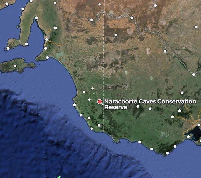
The Naracoorte Caves National Park is about 351 km by road, south east of Adelaide.

Screenshot 2015-06-10 14.46.54

Above: Map showing the location of the park.  Map courtesy of mapcarta.com

Naracoorte Caves National Park is Australia’s only World Heritage site, officially recognise in 1994 due to its importance to the fossils located there.  There are 28 known caves in the park.  Four are open to the public.  The park preserves Australia’s most complete fossil record for the past 500,000 years.  For more detailed information, please see my previous post on this park, or have a look at the following site…..

http://www.environment.sa.gov.au/naracoorte/Home

I set up in a BBQ shelter shed on the edge of the oval, which is adjacent to the main carpark.  It afforded me plenty of shelter from the rain which constantly came down.  You know it is wet and cold when the kangaroos are sheltering underneath trees on the oval, which they were.  For this activation I ran the Yaesu FT-857d, 40 watts and my 40m/20m linked dipole supported on a 7 metre squid pole.

I started off on 40m and called CQ on 7.095.  First taker again was Tony VK5FTVR, followed by Larry VK5LY, Les VK5KLD and Col VK5HCF.  All with great signals from all around South Australia.  Getting wet and cold was made up for by the large number of callers who gave me a shout.  Adrian VK5FANA called in again, running his 5 watts as per usual, with a very nice signal.  I was also called by Lou VK5EEE who was formerly G4OJW in the UK.  I was just Lou’s third QSO with his new VK call.  Welcome to Australia Lou.

A number of other hams running QRP also called in, including Norm VK5GI and Greg VK5GJ, both running just 4 watts (5/7 sent and 5/9 received).  And also Adrian VK5AW running 5 watts from the Riverland (5/9 both ways).  Quite a few mobiles also called in, including Ian VK3TCX mobile north of Bairnsdale, Gerard VK2IO, Peter VK3TKK, Wayne VK2PDW, and Peter VK3PF.

This slideshow requires JavaScript.

Sadly, at about 0540 UTC (3.10 p.m. local time), two stations from VK5 & a VK2 (I know their call signs, but will not mention them here) came up on adjacent 7.093.  They are regular participants in the Kandos Net which commences at 0600 UTC on 7.093.  I was aware that the net was to start at the time and had indicated that I was going to go QRT prior to the net commencing.  However, that did not stop those individuals from firing up on 7.093, just 2 kc below me, where I had been for about one hour.  Clearly they knew I was there, and others were calling/working me.  It was impossible to continue to 7.095 due to the bleed over.

I normally bite my tongue.  But one of these individuals had previously communicated to me that park & SOTA activators should stay away from 7.093 as it was ‘their net frequency’.  On that occasion, after informing this individual that no-one ‘owned’ a frequency, it appears that it has fallen on deaf ears.  So I came up on 7.093 to calmly voice my disapproval of their poor behaviour.  One of the VK5’s sheepishly apologised, but the VK2 station accused me of getting ‘a bit upset over nothing’.  

But out of everything bad, comes something good.  There are some excellent and professional operators around.  And here are two of those.  On the record I would like to thank both Tom VK2KF and Tom VK4ATH (net controllers for the Kandos Group), who had personally heard what had occurred and were very quick to apologise, both via e-mail and on air for the behaviour of a small few.  Not that they should have to apologise for others.  But they did.  Thanks to both Toms.  The Kandos Net is a terrific net which has been running for a very long period of time and should in no way be tarnished by the behaviour of a very select few.

And also thankyou to the two hams who followed me down to 7.093 and also supported me and voice their disaproval.

I then headed up to 14.2498 and started calling CQ.  This was answered immediately by Ray KB6LQV in California in the USA with a nice 5/9 signal.  John VK5BJE was kind enough to spot me on the DX Cluster and this resulted in the European park hunters finding me.  It wasn’t long before the regulars were giving me a shout.  On 20m I worked into the USA, Belgium, Italy, Germany, France, Hungary, Poland, Spain, Israel and VK.  I went on to work 24 stations on 14.248 until things slowed down.

So I tuned across the band and found Tony G7OEM who was pedestrian mobile, calling CQ on 14.197.  Tony had quite a pile up, but I eventually made it (5/5 both ways).

After 2 hours in the park I had a total of 63 contacts in the log.  It was time to head off to Mount Gambier.  It was now 4.10 p.m. and I still had a 100 km drive ahead of me.

Thankyou to those that spotted me on parksnpeaks and thanks to I5FLN, F4HMR, VK2SOL, and IZ1JLG for spotting me on the DX Cluster.

The following stations were worked on 40m SSB:-

  1. Tony VK5FTVR
  2. Larry VK5LY
  3. Les VK5KLD
  4. Col VK5HCF
  5. Les VK5KLV
  6. John VK5BJE
  7. Jeff VK5JK
  8. Adrian VK5FANA
  9. Terry VK3UP
  10. Tim VK3TJK
  11. David Vk5KC
  12. Jim VK1AT/3
  13. Erik VK7EK
  14. Lou VK5EEE
  15. Rob VK4AAC/5
  16. Micj VK3PMG
  17. Cliff VK2NP
  18. Grant Vk5VGC
  19. Ian VK5IS
  20. Ian VK3TCX/m
  21. Mark Vk7MK
  22. Allen VK5FD
  23. Paul VK3DBP
  24. Bruce VK2FBJM
  25. Gerard VK2IO/m
  26. Norm VK5GI
  27. Greg VK5GJ
  28. Peter VK5PET
  29. Brian VK5FMID
  30. Ivan VK5HS
  31. Adrian VK5AW
  32. Phil VK3BHR
  33. Peter VK3TKK/m
  34. Wayne VK2PDW/m
  35. David VK3FDAV
  36. Peter VK3PF/m
  37. Robin VK5TN
  38. Tony VK7LTD

The following stations were worked on 20m SSB:-

  1. KB6LQV
  2. ON4BB
  3. I5FLN
  4. DL2ND
  5. F1BLL
  6. HA6OB
  7. DK9HN
  8. SP6KEP
  9. EA4DTV
  10. WB4JSB
  11. F4HMR
  12. EA1LQ
  13. VK4NAI
  14. DL4PT
  15. IW2NXI
  16. 4X4JU
  17. IK1GPG
  18. DK8PY
  19. VK2SOL
  20. VK2NRB
  21. ON4STA
  22. HA0LG
  23. IZ1JLG
  24. ON5SWA
  25. G7OEM pedestrian mobile

Christmas Rocks Conservation Park

After packing up at Aberdour Conservation Park, I headed back to the Riddoch Highway and travelled south towards my next activation which was the Christmas Rocks Conservation Park, which was to be another unique park for me as an activator.  It was just a very short drive from Aberdour CP.

Screenshot 2015-06-03 19.28.08

The Christmas Rocks Conservation Park was proclaimed in 2014 and is just to the north of the little town of Willalooka.  Don’t blink, because you will miss the park.  There is just one small brown sign on the western side of the Riddoch Highway, with a camera sign and the words Christmas Rocks.  If you’ve reached Willalooka when travelling south, you have come too far.

The park itself consists of some fairly dense scrub and a series of granite rocks which were once part of the archipelago of granite rocks in the shallow sea that covered the Limestone Coast some 25 million years ago.  I recommend taking the time to walk to the top and admire the views of the surround countryside.  It is a very easy 10 minute walk from the carpark.  Sadly, there is no real defined park.  It is another example of the poor state our parks are in South Australia.

Prior to activating, I did exactly that.  I took a walk up to the top of the granite rocks while the showers had disappeared.  Although not high above sea level, there are some very good views of the district.

This slideshow requires JavaScript.

I set up in the scrub about 10 metres in from the carpark.  The weather was still terrible, so I didn’t want to be too far from the vehicle.  I had hoped to take the Yaesu FT-817nd up onto the top of the rocks, but it was just too wet.  So I quickly set up the equipment, my Yaesu FT-757d (set on 40 watts) and a 40m/20m linked dipole supported on a 7 metre squid pole.

This slideshow requires JavaScript.

I called CQ again on 7.095 and this was answered by Tony VK5FTVR at Strathalbyn, followed by Scott VK5FSKS mobile at Swan Reach with a nice 5/8 signal, and then park stalwart, Mick VK53PMG in Stawell in western Victoria.  Eugene VK5ZA mobile at Auburn in the Clare Valley was next, followed by another park devotee, Adrian VK5FANA on the Yorke Peninsula.

Whilst I was operating, the area was alive with birds.  Of the feathered variety!  The gum trees were in flower so that attracted the New Holland Honeyeaters.  There was also a large number of Superb Blue Wrens and Fantails.

After the callers had slowed down, I had a quick tune around the band and found Phil VK2JDL calling CQ from a SOTA peak, Mount Coryah VK2/ NW-004 in the Mount Kaputar National Park VKFF-353.  Phil was my last contact (5/7 both ways), just as the rain started to come down again.  It was a quick pack up and back to the vehicle.

After 40 minutes in the park, I had a total of 22 contacts in the log from VK2, VK3 & VK5.

The following stations were worked:-

  1. Tony VK5FTVR
  2. Scott VK5FSKS/m
  3. Mick VK3PMG
  4. Eugene Vk5ZA/m
  5. Adrian VK5FANA
  6. Anthony VK3LPG
  7. Les VK5KLV
  8. Les VK5KLD
  9. Ian VK5IS
  10. Jim VK5JW
  11. Greg VK5ZGY
  12. Rick VK5BGN
  13. Ivan VK5HS
  14. Peter VK3PF/m
  15. John VK5BJE
  16. Alan VK5FAJS
  17. Paul VK2DEL/m
  18. Terry VK3UP/m
  19. Bob VK5XL
  20. Steve VK3NSC
  21. Phil VK2JDL/p (SOTA)


References.

Tatiara Tourism Group, 2015, <https://www.tatiara.sa.gov.au&gt;, viewed 20th May 2015


Aberdour Conservation Park

Aberdour Conservation Park was my first park activation for the week away in the South East.  I left home early on Thursday morning (4th June 2015), and journeyed down the Dukes Highway to Keith, where I turned off onto the Riddoch Highway.  About 10 km from the park I had a QSO on 40m with Gary VK5ZK, Rick VK5BGN, and a few other VK5 locals.  It was good to try out the new Codan 9350 antenna on the Toyota Hi Lux.

Aberdour Conservation Park is about 35 km south of Keith on the eastern side of the Riddoch Highway (Naracoorte-Keith Road), and about 260 km by road from Adelaide.  It is quite a large park, being 133 hectares in size.  It was dedicated as a Conservation Park in February 1991, and was a gift from the Nankivell family.  In fact Nankivells Road runs on the eastern side of the park.  The park preserves an area of remnant vegetation which is very typical of undulating dune and limestone country of the South East.

Screenshot 2015-06-03 19.16.20 Above:- Map showing the location of the park in SE South Australia.  Map courtesy of mapcarta.com

There has been extensive clearing of the surrounding countryside and the park provides an important habitat for a large amount of native wildlife.  The park contains the Nationally endangered Jumping Jack wattle Acacia enterocarpa.

I haven’t been able to find out an origin of the name of the park.  Unfortunately there is not a lot of information on the internet about this park and DEWNR were unable to assist.  There is a town called Aberdour on the south coast of Fife in Scotland.  Perhaps it has some association.

http://en.wikipedia.org/wiki/Aberdour

Screenshot 2015-06-10 13.39.00

Above:- The boundaries of the park.  Courtesy of http://www.openstreetmap.org

I turned off the Riddoch Highway onto Cannawigara Road and travelled east.  A few km down the road (which is a dirt road), I saw the park sign on my left on the northern side of the road.  There was an access track at the south western corner of the park on Cannawigara Road, but it was extremely wet and sandy and I didn’t feel like getting out and lowering the tyre pressure in the Toyota Hi Lux.  So I continued down Cannawigara Road and turned left into Nankivells Road and travelled north along the eastern boundary of the park.  At the end of Nankivells Road, which becomes a dead end road, there is another sandy 4WD track which follows the northern boundary of the park.  But I turned back around and found a clearing in the scrub, and parked the car on Nankivells Road.

Screenshot 2015-06-10 12.57.29

Above:- Map showing my operating location.  Image courtesy of mapcarta.com

The scrub in the park is very thick, but I had found a nice clearing and quickly set up my fold up table, deck chair, and antenna, trying to beat the rain.  It was not the best of days for park activating, with quite a lot of shower activity and it was very cold.

My first contact after calling CQ on 7.095 was with Adrian VK5FAJH in Port Pirie with a nice 5/9 signal.  This was followed by Tony VK5FTVR in Strathalbyn, and then Rick VK5BGN who I had spoken to from the mobile.  Thanks for coming up to say g’day Rick.  The showers were starting to set in, so I deployed the bothy bag to try to stay dry.  It was pleasing to hear a steady flow of callers from lots of the regular park hunters, but also a number of new callers, from all around Australia.

In fact, during my 45 minutes in the park I had contacts on 40m into VK2, VK3, VK5, VK6, and VK7.  The band seemed to be in quite good condition with 5/7-8 signals coming in from Western Australia.

After a total of 23 contacts, I lowered down the squid pole in the rain, and took out the links in the dipole and started calling CQ on 14.310.  This was answered by Peter VK6RZ firstly with a beautiful 5/9 signal, followed by Max VK6FN who was also 5/9.  But the rain had got the better of me.  It was that heavy and steady that water was seaping through the bothy bag, so it was time to pack up and head for the warmth of the vehicle.  I had a total of 25 contacts in the log and this was a unique park for me as an activator.

Thanks to Paul VK2HV and Peter VK6RZ for spotting me on the DX Cluster and to those that spotted me on parksnpeaks.

This slideshow requires JavaScript.

The following stations were worked on 40m SSB:-

  1. Adrian VK5FAJH
  2. Tony VK5FTVR
  3. Rick VK5BGN
  4. Ivan VK5HS
  5. David VK5KC
  6. Ian VK5IS
  7. Adrian VK5FANA
  8. Allen VK5FD
  9. Paul VK2HV
  10. Jeff VK5JK
  11. Les VK5KLD
  12. Jim VK1AT/3
  13. Greg VK5ZGY
  14. John VK5FANG
  15. Peter VK3PF/m
  16. Andy VK2VOO/m
  17. Geoff VK5HEL
  18. Peter VK6RZ
  19. Tony VK7LTD
  20. Max VK6FN
  21. Mark VK7MK
  22. Ian VK5CZ
  23. Rich VK6HRC

The following stations were worked on 20m SSB:-

  1. Peter VK6RZ
  2. Max VK6FN

References.

Department of Environment and Natural Resources, 1997, Aberdour and Mount Monster Conservation Parks Management Plans

Wikipedia, 2015, <http://en.wikipedia.org/wiki/Aberdour&gt; viewed 10th June 2015