Mount Elephant, VK3/ VS-047

After leaving Mount Leura, we travelled north out of Campberdown along the Campberdown-Lismore Road, passing through the little areas of Chocolyn, Kariah, and Larralea, Our destination was Mount Elephant, VK3/ VS-047, which lies at the foot of Derrinallum.  This was to be our second SOTA summit of the day.

Screenshot 2015-12-10 22.01.16

Above:- Map showing the location of Mount Elephant.  Image courtesy of Open Street Map.

Mount Elephant is a perfect breached scoria cone which last erupted appproximately 5,000 to 20,000 years ago.  As such it is amongst the youngest volcanoes in Australia.  The land on which the summit is located had been privately owned by the Eldridge family since European settlements.  It had been heavily grazed, and ravaged by bushfires in 1944 and 1977.  The summit was known as Swagman’s Lighthouse, a landmark for pioneers to navigate their way throughout western Victoria.  In December 2000, the Eldridge family offered the Mount for sale by auction.  The Derrinallum and Lismore communities rallied and the Mount was purchased by the community.

Screenshot 2015-12-11 08.14.03

Above:- Contour map of Mount Elephant.  Image courtesy of http://www.mountelephant.com.au

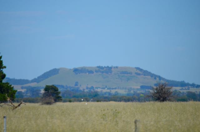
As we drove along the Campberdown-Lismore Road, the summit was clearly visible in the distance.  This is quite flat country, but Mount Elephant dominates the 3rd largest Volcanic Basalt Plain on Earth and can be seen for 60 kilometres in all directions.

DSC_0223

We then turned left onto the Camperdown-Derrinallum Road, and a few kms down the road, we entered the little town of Derrinallum, which only has a population or around 270 people.  There isn’t much here at all.  But I did see a quaint little pub which I had already earmarked for a quick drink after the activation.

An interesting fact about Derrinallum is that on 12 April 2014, the town became the centre of Australia’s biggest explosives clean up, after an explosion rocked the town. A local, Glenn Sanders, also known as ‘The Colonel’, who was an explosives expert and professional mechanic detonated his house which rocked the town and was heard over 15km away. The explosion left the town isolated for a number of weeks.

We then drove out along the Hamilton Highway for a short distance, until we found the turnoff to Mount Elephant.  But excitement quickly turned to disapointment, as we found a locked gate and a sign which read that the summit was only open on Sundays from 1.00 p.m. til 4.00 p.m.  Bugger!  I wondered how the hell I had missed that, as I had checked out the Mount Elephant website prior to leaving on the holiday.

Fortunately, there were some contact numbers on the sign for the Mount Elephant Committee of Management.  We telephoned one of the Commitee members, Lesley, who kindly drove out and met us at the gate.  She was extremely friendly and quite interested in what we were doing.  We followed her up in the 4WD to the carparking area, and then collected all of our radio gear, as she had offered to drive us up a little higher.  This sounded great, as it was a very warm day.  Lesley drove us up to the next gate and Lesley told us that this was as far as we could go by vehicle and we would need to walk the remainder of the way.

This is where all the fun started.  On a mild day, this would be quite a nice walk.  But it was hot!  And the grass on either side of the track was very high.  So Marija and I were very cognisant of making a lot of noise to try to scare off any potential unwanted visitors, in the way of snakes!

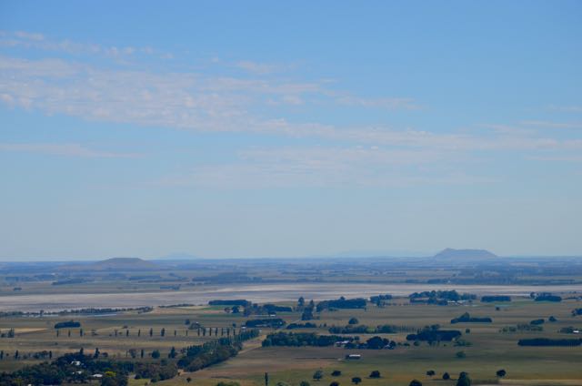
After quite a climb in the heat, and avoiding any snakes, and stopping regularly to remove the grass seeds from our shoes and socks, we made it to the top of Mount Elephant.  There, we were rewarded with some amazing views of the surrounding countryside.  In the distance you can see Mount Buninyong near Ballarat, and the Grampians between Dunkeld and Stawell.  We could also see our previous summit, Mount Leura near Campberdown.

This slideshow requires JavaScript.

Unfortunately there was no shade on the summit.  There are no trees here on Mount Elephant.  All that is at the top is the trig point marking the 339 metre above sea level point, and a small old rainwater tank.  The tank afforded some shade, but not a lot.  There is a small satellite receiver on the trig point, which is used for local GPS tractor guidance systems.

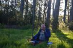
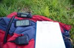
I secured the 7 metre telescopic squid pole to the rainwater tank with the aid of an octopus strap while Marija ran out the legs of the dipole.  For this activation I had brought along the Yaesu FT-817nd and ran 5 watts.
Screenshot 2015-12-10 22.00.16
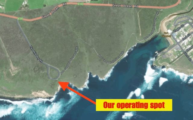
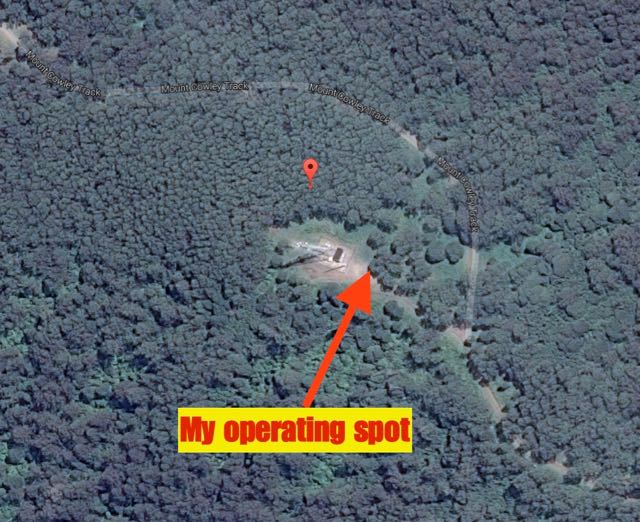
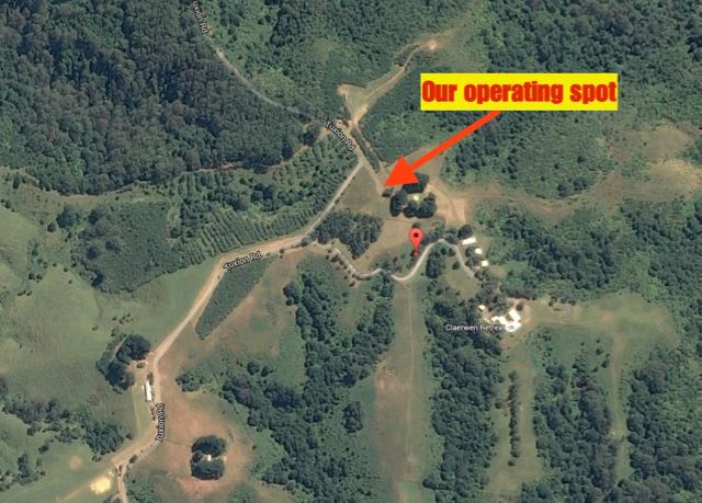
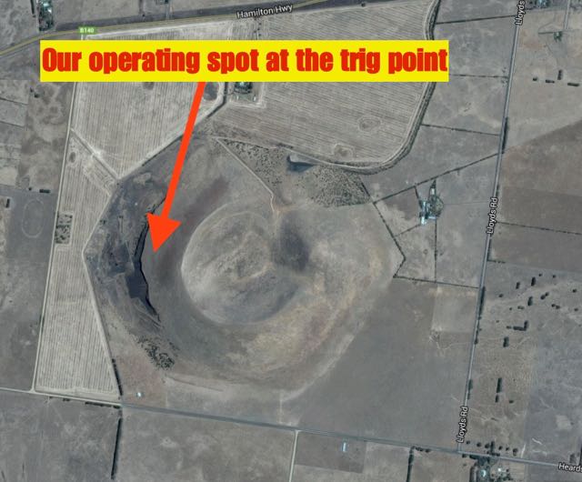
Above:- Aerial view of the summit showing our operating spot.  Image courtesy of google maps.

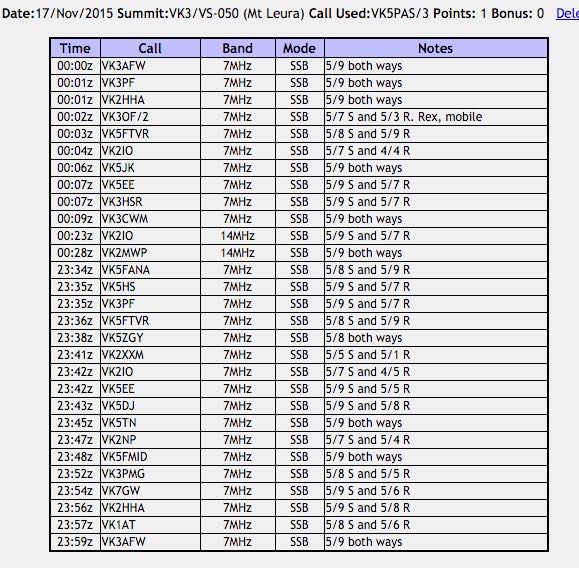
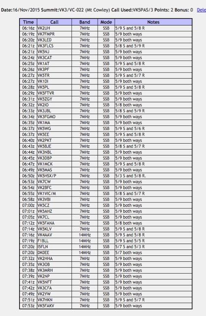
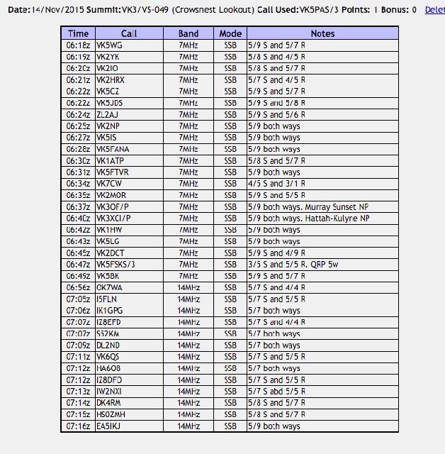
I headed for 7.090 and called CQ and this was answered by Robin VK5TN in Mount Gambier with a very strong 5/9 signal.  Robin gave me a 5/7.  This was followed by a call from Ron VK3VBI (5/9 both ways), then Brian VK5FMID in Mount Gambier (5/9 sent and 5/8 received).  And my fourth qualifying contact was with Tony VK5FTVR at Strathalbyn (5/7 sent and 5/6 received).  The 40m band seemed to be in pretty good shape.

I worked a further 13 stations from VK2, VK3, and VK5, before I was called by Tony VK3VTH who was operating portable from the Lake Tyres State Park, VKFF-0761.  Tony was my last caller on 40m.  And I was pleased there was not a pile up as this was a very hot summit and I was looking forward to that drink in the hotel.

So we lowered the squid pole and removed the links in the 20m/40m linked dipole, and I called CQ on 14.310.  This was answered by Rick VK4RF/VK4HA, followed by Brett VK2VW, Gerard VK2IO, and finally John VK6NU.  I was very pleased to be able to get John in the log.  Although not strong (5/1), he was perfectly readable due to the non-existant man made noise on Mount Elephant.

We spent just 30 minutes on the summit.  I had a total of 23 stations in the log.

The following stations were worked:-

Screenshot 2015-12-10 21.42.10

We then commenced the climb down along the Borbidge walking track to the the carpark at the base of the Mount.

After about 25 minutes we reached the carpark and some welcome shade.  The quarry situated at the carpark provided scoria for the nearby rail line to Ararat from 1911 to 1916.

After getting back to the car and downing 2 litres of water each, we headed off to the Mount Elephant Hotel.  This was without a doubt, one of the hardest one point summits I have activated.  Mostly due to the heat, making it a challenging little walk.

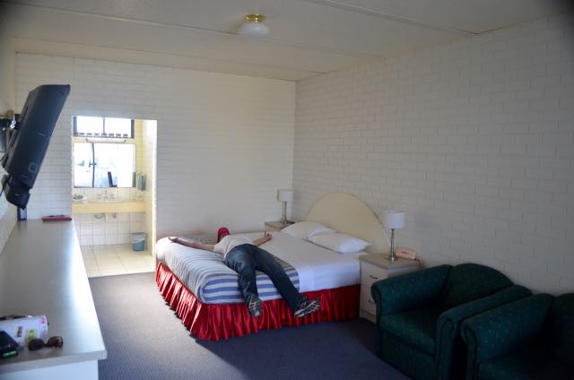
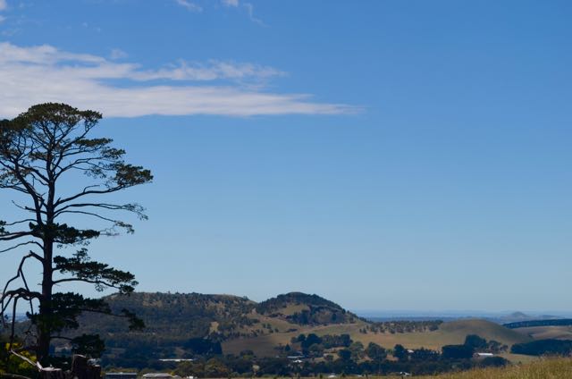
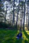
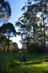
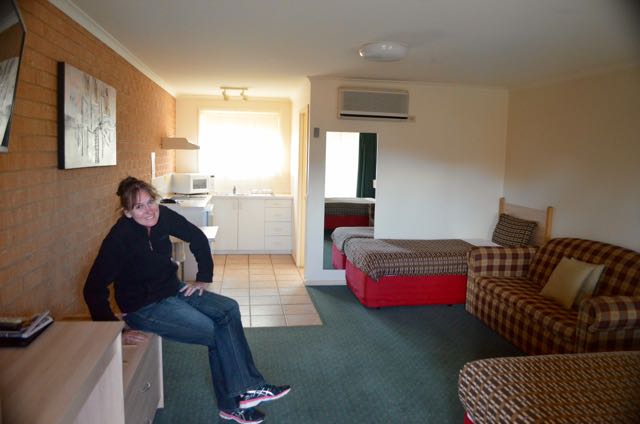
After a few quiet ales at the hotel, we drove north out through Mingay and Skipton on the Lismore-Skipton Road, until we reached the Western Highway at Beaufort.  We then drove west and into Ararat and booked in to our motel.  Marija was a little exhausted as you can see from the photograph below.

DSC_0269


References.

Wikipedia, 2015, <https://en.wikipedia.org/wiki/Derrinallum&gt;, viewed 10th December 2015

Mount Leura VK3/ VS-050

We had three planned activations for Wednesday 18th November, 2015.  They were all hilltop activations for the Summits on the Air (SOTA) program.  They being Mount Leura, and Mount Elephant whilst on our way to Ararat, and One Tree Hill, once we had reached Ararat. We had booked in to stay for two nights at Ararat.

Our start to the day on Wednesday morning was breakfast at one of the cafes on the foreshore at Lorne.  It was a beautiful warm morning, and it was very relaxing, enjoying the cooked breakfast, the freshly squeezed orange juice, and a hot coffee, whilst enjoying the view.

We left Lorne, and headed out along the Deans Marsh-Lorne Road, through the magnificent Great Otway National Park.  We had a 100 km drive ahead of us until we reached our first summit, Mount Leura.  We were rewarded with some nice views of the countryside as we exited the north western side of the Otway Ranges.

We continued north, on to the little town of Deans Marsh and then travelled on the Birregurra-Deans Marsh Road until reaching Birregurra.  We then travelled north west along the Warncoort-Birregurra Road until we reached Warncoort, where we turned left onto the Princes Highway.  This took us through Colac and on to Campberdown.

Screenshot 2015-12-10 20.40.14

Above:- Map showing the location of Mount Leura.  Image courtesy of google maps.

As we drove towards Campberdown we saw a little hill which we assumed to be the summit.  Wrong!  The summit came and went and looked way too close on the GPS to be Mount Leura.

We continued on towards Campberdown and saw another summit which again we assumed to be Mount Leura.  Wrong again!  This turned out to be another false alarm.

DSC_0171

Mount Leura, VK3/ VS-050, and the adjacent Mount Sugarloaf are part of a large volcanic complex known as the Leura Maar, which was formed over 20,000 years ago, following a series of major volcanic eruptions.  Mount Leura is 310 metres above sea level, and is worth 1 SOTA point.  The summit is located in the third largest volcanic plain in the world.  Mount Leura is believed to have last erupted between 5,000 and 20,000 years ago.  The name Leura, means ‘big nose’ in local aboriginal dialect.

For more information on Mount Leura, please see the following website…..

http://www.mtleura.org.au/

We accessed the summit via Mount Leura Road which is on the south eastern side of Campberdown.  Prior to heading up the hill we reached a welcome sign for the Mount Leura and Mount Sugarloaf Reserves.

We drove to the carpark at the top of Mount Leura Road.  There are some great views from here of the surrounding countryside.  There are also some very good interpretive signs.

We set up at a conveniently provided table and benches adjacent to the carpark.  We used a fencepost to secure the 7 metre telescopic squid pole, with the handy octopus strap.  It was quite a warm morning and unfortunately there was no shade.

Screenshot 2015-12-10 20.39.54

I was set up and ready to go by 2330 UTC (8.30 a.m. Victorian local time).  I commenced calling CQ on 7.090 and this was immediately answered by Adrian VK5FANA on the Yorke Peninsula with a strong 5/8 signal.  This was followed by Peter VK3PF with a very strong 5/9 signal, and then Ivan VK5HS who was also 5/9 from the Riverland region of South Australia.  My fourth and qualifying QSO was with Tony VK5FTVR at Strathalbyn, south of Adelaide with a strong 5/8 signal.

It was a weekday so I didn’t expect to be swamped by callers.  But I was pleasantly surprised to have quite a good steady flower of SOTA chasers from VK1, VK3, VK5, and VK7.  Band conditions were very good with all signals between 5/7 to 5/9.

I worked 17 stations on 40m prior to the UTC rollover, and then a further 10 stations on 40m on the new UTC day.

I then took a break from the radio and went for a short walk up to the trig point on the summit and admired the views of Campberdown and the surrounding countryside.

We were able to see our next SOTA summit in the distance, Mount Elephant, VK3/ VS-047.

DSC_0195

I returned to my operating spot and lowered the squid pole and removed the links in the dipole so I could operate on 20m.  I headed to 14.310 and called CQ a number of times, but unfortunately I only had two takers.  They being Gerard VK2IO and Andrew VK2MWP.  Some QSB was noted on their signals.

We packed up the gear and headed in to Campberdown.  I was satisfied with a total of 29 contacts in the log, and a unique SOTA summit as an Activator.

The following stations were worked:-

Screenshot 2015-12-10 20.33.35

Once back in Campberdown we visited the Campberdown Visitor Centre which is located in the old courthouse.  This is an excellent tourist centre and the volunteer on duty was extremely helpful and friendly.  She clearly had a great love for her town.  We did not have a lot of time, but we did take a quick drive around the town to admire some of the heritage buildings, and we had also been encouraged to go for a drive out to the two volcanic lakes.

We then drove out to the deep volcanic crater lakes, Bullen-Merri and Gnotuk.  Bullem-Merri has a maximum depth of 66 metres and is clover leaf in shape, indicating that it was probably formed by two overlapping maar volcanos.

Below is a view of Mount Leura from the Campberdown-Cobden Road.

DSC_0221

After leaving Campberdown, we headed off to our next SOTA activation, at Mount Elephant, near the little town of Derrinallum.


References.

Wikipedia, 2015, <https://en.wikipedia.org/wiki/Mount_Leura&gt;, viewed 10th December 2015.

Point Addis Marine National Park, VKFF-0952

Tuesday, the 17th November 20165, was day 11 of our trip away.  We had spent a quiet Monday night in the apartment, and all of this day was a planned tourist day.  So we had a little bit of a sleep in, but the quiet of the morning soon changed with the arrival of some Sulphur Crested cockatoos on our doorstep.  They were very tame and allowed us to hand feed them.  It wasn’t long before the magpies had joined in the party.

After breakfast we drove in to Lorne and had a quick look around.  This included a visit to Lorne’s historic swing bridge which spans the mouth of the Erskine River.  The bridge was constructed in 1937.  We also took a walk along Lorne’s main street on the foreshore.

We drove up to have a look at the very majestic, Grand Pacific Hotel in Lorne, which can be located at the top end of Mountjoy Parade.  Whilst there we booked a table for a meal that evening.  The Grand Pacific was built in 1875 and features superb ocean views.

Marija was very keen to travel to Torquay, about 47 km north west of Lorne.  So that is where we headed.  We stopped a number of times along the way to enjoy the amazing views of the coastline along the Great Ocean Road.  Along the way I booked in to the morning net on 40m run by Ron VK3MRH, who himself has recently become a very avid park hunter.

No trip along the Great Ocean Road is complete until you have stopped at the Memorial Arch.  So of course, that’s what we did.  Along when 10,000 other tourists.  Well, okay, that might be a slight exaggeration.  But there were certainly a lot of tourists here.

The Memorial Arch is a tribute to the World War One servicemen who constructed the Great Ocean Road.  The current day arch is the third to be built.  It replaced the second arch which was destroyed in the February 1983 Ash Wednesday bushfires.  The arch consists of a timber log archway with cement and stone supports on each side.

The Great Ocean Road was completed in 1932 and the arch was first erected in 1939.  It was replaced in 1973 and again in 1983.  There are a number of plaques here which tell all about the story of the construction of the Great Ocean Road.

This slideshow requires JavaScript.

There were also some very impressive homes along the Great Ocean Road.  I gazed at a number of them in awe as we passed them, including the one below.  What great views.  And even better, from an amateur radio operator point of view….what a great take off!

DSC_0087

We drove into the beautiful little town of Aireys Inlet, about 19 km north west of Lorne.  Aireys Inlet is a lovely little coastal town, and has a population of around 1,200 people.  The town was devastated during the 1983 Ash Wednesday bushfires, with a large number of homes completely destroyed.  The area experienced a brief lull, but interest in the area soon resumed and has been steadily increasing ever since.

We stopped briefly to have a look at the bark hut in Aireys Inlet.  In 1852, Geelong butchers, Thomas Pearse and Robert McConachy, purchased the Anglohawk cattle station which ran from the Aireys inlet side of Painkalac Creek back towards Anglesea.  Initially they built a slab house, a stone shed and 2 bark huts near there.  The bark hut in Aireys Inlet is a replica of one of the hunts, which survived until 1983, when it was destroyed by bushfire.

We then stopped off at the Split Point lighthouse at Aireys Inlet.  Construction on the lighthouse commenced in late 1890 and the lighthouse was first illuminated in September 1891.  Prior to this, there were about ten shipwrecks along the surrounding coastline.  It was these tragedies that prompted authorities to plan the lighthouse.  Originally called Eagles Nest Point, the lighthouse was renamed Split Point in 1913.

The lighthouse has featured on series 6 of Masterchef.  There is a cairn here which marks the burial site of Thomas Pearsse (mentioned above) and his wife, Martha.

For more information on the lighthouse, have a look at……

http://splitpointlighthouse.com.au/

We continued along the Great Ocean Road towards Torquay, stopping briefly to enjoy the view at Urquart Bluff.  We then drove down to the beach and had lunch, whilst sitting back enjoying the magnificent views and the sensational sunshine.

DSC_0108


After lunch we drove on to the little town of Anglesea and stopped at the Anglesea Lookout Reserve which is also known as Loveridge Lookout.  The lookout was built in 1938 as a memorial to James Loveridge by his widow Bertha.  It is located near the former Loveridge owned property, ‘Anglecrest’.  This site was chosen by Bertha, as it was James Loveridge’s favourite viewing location of Bass Strait.  Sadly, the Ash Wednesday bushfires were to take another victim, with the destruction of the original ‘Anglecrest’ homestead.  During the Second World War, Loveridge Lookout was used as an observation post for the Volunteer Air Observers Corps.

We continued on to Torquay, which is just 21 km from Geelong.  This popular tourist town is the gateway to the Great Ocean Road from Melbourne.  Torquay’s population is around 10,200 people.

Torquay is famous for its surf beaches, with Jan Juc and the world famous Bells Beach located on the town’s south-west outskirts.  As a result, there is a major complex in the town which features a number of surf shops.

It was a warm afternoon, so Marija and I took the time out to stop off at one of the cafes in Torquay and enjoy a smoothie each.  It was whilst we were sitting back relaxing, that I was going through some of the tourist brochures and learnt that we would be passing the Point Addis Marine National Park on the way back to Lorne.  A little bit of groveling to Marija, and it was agreed upon that I could do a quick activation of the park.

DSC_0124.jpg

The park was just a 14 km drive from Torquay.

Screenshot 2015-12-10 17.23.32

Above:- Map showing the location of the Point Addis Marine National Park.  Image courtesy of Forest Explorer.

We then headed back south west along the Great Ocean Road, and took the turn off to Bells Beach, travelling along Bones Road.  It wasn’t long before we reached the world famous Bells Beach.  It is named after John Cavert Bell, of the family who first took up a pastoral run in the area back in the 1840’s.  Bells Beach is the home to the world’s longest running surfing competition – the Rip Curl Pro Surf & Music Festival.  This was formerly known as the Bells Beach Surfing Classic and was first held in January 1961.

We continued along the Bells Beach Road and then Jarosite Road, until we reached the Great Ocean Road.  A short distance from there, we turned left into Point Addis Road.  We stopped off briefly at the lookout for Southside Beach.  As it turns out this is a nudist beach.  But my nudist days are well and truly passed me, so we didn’t venture down to the beach.  I am sure all of the nudists down on the beach would have appreciated my decision!

We continued along Point Addis Road and along the way I spoke with Tony VK3VTH who was operating portable from the Gippsland Lakes Coastal Park VKFF-0747.  Tony had a good 5/9 signal into the mobile.  We continued on until we reached the carpark at the end of Point Sddis Road.  There weren’t any possibilities for activation positions along the way, so we decided to try to set up in the carpark in one of the corners away from any of the tourists.

A little bit of information about Point Addis Marine National Park…..the park features spectacular scenery with wide sandy beaches, limestone and sandstone cliffs and rocky platforms.  The park is 4,600 hectares in size and is part of a system of 13 Marine National Parks in Victoria.  The park is considered to be one of the most biodiverse and unique marine ecosystems in the world.  Bells Beach is just one of the features along the 9km of rugged coastline between Torquay and Anglesea.

Screenshot 2015-12-10 17.23.06

Above:- Map showing the park, just south west of Torquay.  Image courtesy of Forest Explorer.

There is a boardwalk here at the end of Point Addis Road, which allows you to view the magnificent coastline.  If you are here between May and September, you may also be fortunate enough to see a whale.

I secured the squid pole to a fencepost, with the assistance of an octopus strap, and stretched out the legs of the 20m/40m linked dipole, securing them to the fence.  I then sat back in my deck chair and turned on the Yaesu FT-857d.  Before calling CQ I had a look around the band in the hope of working Tony VK3VTH, and perhaps finding some other park activators. I found Tony still on 7.144, calling CQ, so I gave him a shout (5/9 both ways).

Screenshot 2015-12-10 17.22.26

Above:- Map showing the park.  Our operating spot was right at the tip of Point Addis.  Image courtesy of Forest Explorer.

I then headed up the band to 7.150 and started calling CQ.  It wasn’t long before the park hunters had found me.  My second contact for the activation was with avid park hunter, Brett VK2VW, followed by another park stalwart, Mick VK3PMG, and then Steve VK7CW, who is another park regular.

I went on to work a total of 49 stations on 40m SSB.  Band conditions were excellent, with some very strong signals from VK1, VK2, VK3, VK4, VK5, and VK7.  Well at least band conditions were good.  Because the weather conditions had deteriorated rapidly.  The afternoon had started out beautifully with bright sunshine and just a gentle sea breeze.  But after about an hour of operating, the wind had picked up dramatically, and I lost the squid pole on a couple of occasions.  This resulted in another octopus strap being required to keep it upright.

As we had booked to go out for tea that evening at Lorne, I was running a bit short of time.  So battling with the wind, I lowered the squid pole and with Marija’s assistance we removed the links and then raised the squid pole back into position.  I went to 14.310 and called CQ and this was answered by Mr. Reliable, Rick VK4RF/VK4HA.  Next up was Les VK5KLV from Port Augusta.  I was very surprised to hear Les with such an exceptionally good 5/8 signal.  I thought we might have been a little too close for 20m.  I worked a further seven stations on 20m from VK2, VK4, VK6, New Zealand and Russia.  Unfortunately it was way too early for Europe on the long path.

We also had some onlookers during the activation.  A busload of tourists arrived, and I took the time to explain to them what this idiot with a squid pole was doing in a carpark overlooking the ocean.  They seemed very interested.  We were also visited by some Paramedics.  Apparently someone had fallen down a cliff face.  I never actually found out if they were rescued.

So, after about 90 minutes in the park, I had a total of 59 QSOs in the log and a brand new park under my belt as an activator.  It was time to pack up and head back to Lorne and head out for tea.

The following stations were worked on 40m SSB:-

  1. VK3VTH/p (Gippsland Lakes Coastal Park VKFF-0747)
  2. VK2VW
  3. VK3PMG
  4. VK7CW
  5. VK5FTVR
  6. VK3OHM
  7. VK3FALE
  8. VK5TN
  9. VK3MRH
  10. VK2HHA
  11. VK3PF
  12. VK3ZMD
  13. VK3DAC
  14. VK7LTD
  15. VK3FPBI
  16. VK2YW
  17. VK5EE
  18. VK2NP
  19. VK2IO
  20. VK4AAC/5
  21. VK5BJE
  22. VK5HCF
  23. VK2GKA
  24. VK5DJ
  25. VK5ZGY
  26. VK2FADV
  27. VK5FANA
  28. VK5NRG
  29. VK3KIS
  30. VK5FMID
  31. VK5ATQ
  32. VK3CFA
  33. VK4RF
  34. VK4HA
  35. VK7WN
  36. VK3DBP
  37. VK3VIN
  38. VK2PKT
  39. VK3GB
  40. VK1VIC/m
  41. VK3TKK
  42. VK2FVG
  43. VK3TJK
  44. VK3FQSO
  45. VK5KLB
  46. VK3PAT
  47. VK4ARW
  48. VK3UYS
  49. VK5HS/m

The following stations were worked on 20m SSB:-

  1. VK4RF
  2. VK4HA
  3. VK5KLV
  4. VK4ARW
  5. VK4HG
  6. RN3QN
  7. ZL4KD
  8. VK2HOT
  9. VK4BX
  10. VK6ADF/m

That night we enjoyed a very enjoyable evening at the Grand Pacific Hotel in Lorne.


References.

Parks Victoria, 2015, <http://parkweb.vic.gov.au/explore/parks/point-addis-marine-national-park&gt;, viewed 10th December 2015.

Monument Australia, 2015, <http://monumentaustralia.org.au/themes/conflict/ww1/display/31148-great-ocean-road-memorial-arch/photo/1&gt;, viewed 10th December 2015.

Wikipedia, 2015, <https://en.wikipedia.org/wiki/Aireys_Inlet&gt;, viewed 10th December 2015

Split Point Lighthouse, 2015, <http://splitpointlighthouse.com.au/&gt;, viewed 10th December 2015

Wikipedia, 2015, <https://en.wikipedia.org/wiki/Bells_Beach,_Victoria&gt;, viewed 10th December 2015


Mount Cowley VK3/ VC-022 and Great Otway National Park

On Monday morning, 16th November 2015, after breakfast, Marija and I headed west out of Apollo Bay along the Great Ocean Road.  Our first stop of the day was Maits Rest which is about a 15 minute drive west of Apollo Bay.  We had passed Maits Rest on the way in to Apollo Bay on Saturday, but didn’t have enough time to stop.  And we had passed it again on Sunday on our way out to the Great Otway National Park.  So this was third time lucky for us.

Maits Rest has an easy self guided circuit walk through magnificent rainforest in the Great Otway National Park.  A wooden boardwalk has been built over the tree-fern gullies and moss covered roots.  The walk is 800 metres in length and starts and finishes at the carpark just off the Great Ocean Road.  It is well signposted.  Many of the trees here are up to 300 years old and this is something not to be missed if you are driving along the Great Ocean Road.  The area was named after former forestry patrol officer Maitland Bryant who used to rest his horses here during patrols of the area.

We then travelled back along the Great Ocean Road and back into Apollo Bay. Along the way we were rewarded with some great views out to the east of Apollo Bay

DSC_0944

We then went to Marriners Lookout, which is located atop a hill on the northern outskirts of Apollo Bay.  Access is via Marriners Hill Road which runs off the Great Ocean Road.  There is an easy 10 minute walk from the carpark to the lookout area.  The lookout is actually on private property and has been kindly opened up by the land owners.  The lookout is also a popular take off point for hang gliders.

We then continued north west along the Great Ocean Road and soon came across the rather unusual collection of stones on the beach.  Obviously strategically placed there by passers by over the years.  So we couldn’t help ourselves.  We stopped and each carefully placed a rock on the top of an existing pile.

Our next stop was the Carisbrook Waterfalls near Sugarloaf, about 16 km east of Apollo Bay.  It is just a short 15 minute (300 metre) walk to the waterfalls from the carpark just off the Great Ocean Road.  At the end of the walk there is a viewing platform set across the valley from the falls.  Carisbrook Falls are one of the highest falls in the Otway Ranges, but they do not fall vertically.  Rather, they rush 50 metres down a diagonal rock face.  Unfortunately the lookout is a long way from the waterfall itself and you cannot see all 7 tiers of the waterfall.

We then stopped briefly at the Cape Patton lookout, which is about 5km on the Apollo Bay side of Kennet River.  The lookout offers spectacular views of the coastline.  The cliffs here are some of the highest along the Victorian coastline.  Cape Patton was named after Vice Admiral Phillip PATTON by Lieutenant James GRANT on the Lady Nelson in 1800.

We then stopped off to have a look at the memorial to the Godfrey, just north of Separation Creek.  The Godfrey was a barque which was built in Greenock Scotland in 1861.  It was sailing from San Fransisco and was bound for Melbourne when it was wrecked at this site in March 1891.  Fortunately there was no loss of life.  However, in three separate boating accidents, five men drowned during salvage operations.

We stopped a number of times along the way for some photo opportunities and to view the amazing coastline.  This included Artillery Rocks, which was named after the cannon-ball concretions in the Cretaceous sandstone outcrops here.  We also stopped at Mount Defiance Lookout.  There is also an information board here re William Buckley, who was an English convict who was sentenced to 14 years and transported in 1803 to Australia.  Soon after arriving Buckley escaped, and made his way along the coast.  He was given up for dead and lived in an Aboriginal community for around 32 years.  It is believed that due to Buckley’s amazing survival, the term ‘you’ve got Buckley’s chance’ originated.

Our next stop was the Sheoak Falls.  It is a quick easy 10 minute walk to the falls.  Although the water across the falls does not fall a great distance, the water passes over a dark rock face into a deep waterpool, within a natural amphitheatre.  It is a very pretty location.

We continued on to Lorne and booked in to our accomodation which was the Chatby Lane Luxury Apartments.  These are very nice apartments in a quiet and scenic part of Lorne.

http://www.chatbylane.com.au/

We unpacked and freshened up and made sure all the radio equipment was ready for out intended activation at Mount Cowley for the Summits on the Air (SOTA) program.

After leaving the motel we headed out to Teddy’s Lookout, which is at the end of George Street, Lorne.  It is just a short walk to the lookout which offers spectacular views of the St. George River and the Great Ocean Road coastline.  We could see our intended destination, Mount Cowley, off in the distance.

On the way out to Mount Cowley we called in to Erskine Falls, about 10 km out of Lorne.  There is a walking trail and steps down to the falls which cascade over one of the highest drops in the Otways.  These are very beautiful falls.  But beware!  It is easy going down, but the steps down are very very steep and coming back up is a real calf burner.  There are warnings at Erskine Falls about the walk back up.

Mount Cowley, was to be our third SOTA activation for the trip.  Mount Cowley, VK3/ VC-022 is  660 metres above sea level and is worth 2 SOTA points.  There is a very large fire and communications tower on the summit, so Mount Cowley is quite distinguishable in the Otway Ranges.  This is one of three fire spotting towers in the Otways.

Screenshot 2015-12-09 18.18.34

Above:- Map showing the location of the summit, south west of Geelong.  Image courtesy of google maps.

The summit is located about 18 km by road, west of Lorne.  But remember, these are windy roads through very dense rainforest, so there is a lot of wildlife, which further slows down travel time.

Screenshot 2015-12-09 18.18.22

Above:- Map showing the location of the summit, west of Lorne.  Image courtesy of google maps.

After leaving the Erskine Falls we travelled out west along Erskine Falls Road until we reached the Benwerrin-Mount Sabine Road.  We turned left here and drove south until we reached Garvey Track.  This track does appear on some maps as the Mount Cowley Track.  In any event, the track is well signposted and also is signed ‘Mount Cowley’.

DSC_0021

The track is fine for conventional vehicles and is well maintained.  It was slow going, but that was only due to the amount of wildlife that was out and about.  There were a lot of kangaroos.

DSC_0022

We drove up the track about 1.5 km until we found a small dirt road leading to the summit.  You cannot miss this because of the large telecommunication tower at the summit.  If you were looking for great views from the summit, forget it.  The summit is densely wooded and there are very few views of the surrounding countryside.

I set up on the south eastern side of the tower.  There was plenty of room to stretch out the 20m/40m linked dipole.

Screenshot 2015-12-09 18.17.59

I was on air and ready to go by 0615 UTC (4.15 p.m. Victorian local time).  I could not get on to 7.090 as the Kandos Net was still operating on 7.093, so I went down a little lower to 7.088 and started calling CQ.  My first taker was Andrew VK2UH with a beautiful 5/9 signal.  This was followed by Mark VK7FMPR, then Col VK3LED, and my fourth and qualifying contact was with Brett VK3FLCS.

It wasn’t long before I had a mini pile up going, with callers from all over eastern Australia in VK1, VK2, VK3, VK5 and VK7, all with very good signals.

After working a total of 35 stations on 40m I lowered the squid pole and removed the links and then re-erected the squiddie and headed off to 20m.  I called CQ on 14.310 and it wasn’t long before I had my first taker on 20.  And it was my good mate Peter VK4AAV from Caloundra.  This was followed by a handful of callers from Europe: F1BLL in France, I5FLN in Italy, and DK0EE in Germany.  But despite many CQ calls, I had no further takers.  It was still a little early for long path 20m propagation into Europe.

I headed back to 40m for one last listen before going QRT.  This time I called CQ on 7.144 and this was answered by Dennis VK2HHA (5/9 both ways), followed by Rod VK3OB (5/9 both ways), and then Ron VK3MRH (5/9 both ways).  The 40m band was certainly working well. I worked a further 6 stations before deciding it was time to pack up and head back in to Lorne.

Whilst on the summit I had a few noisy visitors.  But they weren’t tourists, nor were they maintenance people.  They were kookaburras and Sulphur crested cockatoos.

So after about 90 minutes on Mount Cowley, I had a total of 48 contacts in the log.

The following stations were worked:-

Screenshot 2015-12-09 18.14.28


References.

Visit Victoria, 2015, <http://www.visitmelbourne.com/&gt;, viewed 9th December 2015

World of Waterfalls, 2015, <http://www.world-of-waterfalls.com/&gt;, viewed 10th December 2015

Only Melbourne, 2015, <http://www.onlymelbourne.com.au/place-names-coast-of-victoria#.VmkXcuOGRBc&gt;, viewed 10th December 2015

Coastal Stays, 2015, <http://www.coastalstays.com/mt-defiance/&gt;, viewed 10th December 2015

Great Otway National Park VKFF-0405, The Redwoods Picnic Area

After leaving the Cape Otway lighthouse we decided that we would visit the Otway Fly.  No, that’s not a hairy, six legged pest!  The Otway Fly is a treetop adventures venue which consists of the Treetop Walk, and also the Zipline Eco-Tour.  The Treettop Walk is a 1 hour rainforest walk experience that is about 2 km in total length, and features a 600 metre long and 30 metre high, steel structured treetop canaopy walkway which takes you right into the treetops of the rainforest.  The Zipline-Eco-Tour is a 2.5 hour, fully guided experience and included training and simulation.  It inclues 8 cloud stations, 6 flights and 2 suspension bridges.

We travelled north along the Great Ocean Road, to Lavers Hill and then back east on the Colac-Lavers Hill Road to the little area of Ferguson.  From there we travelled south along Phillips Track.

For more information on the Otway Fly, please have a look at…..

http://www.otwayflytreetopadventures.com/

This slideshow requires JavaScript.

After leaving the Otway Fly, we continued east along the Beech Forest-Lavers Hill Road, until we reached the little town of Beech Forest.  This is the home town of Albert Ernest Clifford ‘Cliff’ YOUNG, who was an Australian potato farmer and athlete.  He is best known for his unexpected win of the inaugural Sydney to Melbourne Ultramarathon in 1983, at the tender age of 61 years.  There is a little monument here in Beech Forest, which celebrates his life.

Also worth a look are the wooden sculptures designed by chainsaw sculptor, Brett DAVIES.  The sculptures comprise of a pioneering woman with babe in arms, a woodcutter to represent the timber industry, an indigeneous man in a possum skin coat, and a potato grower.

After leaving Beech Forest we travelled south along Binns Road, until we reached a beautiful little area called The Redwoods Picnic Area, which is located in the Great Otway National Park on the Aire River, near the junction with Farrell Creek.  Park activation, park activation, park activation!  Those were the thoughts going through my head and I managed to convince Marija that I would only be a short time.

There was a beautiful little lawned area right alongside a plantation of Californian Redwoods ‘Sequoia Sempervirens’.  This is where we set up the fold up table and deck chair.  There was plenty of room to stretch out the dipole, the ends of which I secured to some of the nearby trees.

I commenced getting on air, whilst Marija explained to some 4WDers in the carpark, exactly what I was doing.

Screenshot 2015-12-09 17.09.50

Above:- Aerial image showing our operating spot.  Courtesy of google maps

Screenshot 2015-12-09 17.10.23

Above:- Map showing the location of where we were operating from.  Image courtesy of http://www.here.com

After turning on the radio I had a quick tune around the band and heard the dulcet tones of Bill VK3LY who was chatting away on 7.110 with some other stations. I had met Bill a number of days earlier whilst I was portable in the Bay Of Islands Coastal Park.   Bill was actually mentioning that he had caught up with me, so I decided to pop in and say hello.  I spoke with Bill, Bob VK5FPAC, Ian VK3AXH, and Bruce VK3FBNG portable at Cow Samp near Gunbower.  All were 5/9 signals.

I then headed up to 7.144 and started calling CQ.  Unfortunately there was no mobile phone coverage so I could not spot myself on parksnpeaks.  But it wasn’t long until I had my first park hunter, and it was Jeff VK5JK at Encounter Bay south of Adelaide, with a nice 5/9 signal.  Next up was Peter VK7LCW at Penguin in Tasmania, followed by Shaun VK3VLY and then Gerard VK2IO.

A few QSOs later I was called by Gordon VK5GY who was portable in the Mark Oliphant Conservation Park in the Adelaide Hills (5/9 both ways).

After working a total of 20 stations on 40m in VK2, VK3, VK4, VK5 and VK7, I decided to have a quick listen on 20m.  In any event, I was experiencing a little bit of QRM from European stations on 40m from adjacent to where I was operating from on 7.144.

After lowering the squid pole and removing the links in the dipole, I headed for 14.310 where I called CQ.  My first taker was Rick VK4RF/VK4HA with a very nice 5/9 plus signal.  My first European followed after my contact with Rick, and that was Luciano I5FLN.  This was followed by 9A7C in Croatia, S52KM in Slovenia, and then Max IK1GPG in Italy.  I worked a further 6 stations on 20m, including John VK6NU, and a new country for me whilst portable, E51KIK in the South Cook Islands.

It was 4.30 p.m. and we still had quite a drive to get back to Apollo Bay, so it was time to pack up and hit the road.  I had a total of 32 contacts in the log.

We had intended to continue south down Binns Road until we reached the Great Ocean Road, but the local 4WDers convinced us that this would be a long drive, so we drove back to Apollo Bay via

The following stations were worked on 40m SSB:-

  1. VK3LY
  2. VK5FPAC
  3. VK3AXH
  4. VK3FBNG/p
  5. VK5JK
  6. VK7LCW
  7. VK3VLY
  8. VK2IO
  9. VK2PKT
  10. VK5GY/p (Mark Oliphant Conservation Park)
  11. VK3TJK
  12. VK5NFT
  13. VK5SFA
  14. VK3NCC
  15. VK4RF
  16. VK4HA
  17. VK5NRG
  18. VK2NP
  19. VK3UT
  20. VK5JDS

The following stations were worked on 20m SSB:-

  1. VK4RF
  2. VK4HA
  3. I5FLN
  4. 9A7C
  5. S52KM
  6. IK1GPG
  7. E51KIK
  8. VK6NU
  9. VK4SC
  10. VK4GSW
  11. DK4RM
  12. VK4QQ

Great Otway National Park VKFF-0405

We had spent a quiet night in the motel room on Saturday night, and had a relatively early night.  We had enjoyed some fish and chips from the local take way.  So on Sunday morning, 15th November, 2015, both Marija and I awoke quite refreshed.  After breakfast we headed out to our one and only planned activation, the Great Otway National Park, VKFF-0405, as part of day 3 of the 2015 Keith Roget Memorial National Parks Award (KRMNPA) Activation Weekend.

Screenshot 2015-12-08 21.49.44

Great Otway National Park is about 103, 185 hectares in size and protects extensive forest and much of the coastline between Torquay in the east and Princetown in the west, in south-west Victoria.  It was gazetted in 2005 and includes the former Otway National Park, and Melba Gully State Park, the majority of Angahook-Lorne State Park and Carlisle State Park, a number of former State Forest areas, many smaller reserves and other areas of public land.  The park encompasses a significant portion of the Otway Ranges and foothills, with its coastal boundary generally being the low water mark.  The park contains a huge diversity of life, with ecosystems ranging from ocean beaches to cool temperate rainforest.

We travelled west out of Apollo Bay, along the Great Ocean Road.  We proposed to activate the park off Lighthouse Road, on the way to the Cape Otway lighthouse.

Screenshot 2015-12-08 21.47.54

It wasn’t far out of Apollo Bay and we already had the park off to our left.  We passed the road to Shelly Beach, but after discussion in the car, we decided to stick to plan A, and we continued on towards Cape Otway.

DSC_0804

This section of the Great Ocean Road is very scenic.  You soon reach a point when the park is on both your left and right.  Magnificent tall trees shelter the understorey below, allowing ferns to flourish.

We turned down Lighthouse Road, and travelled south down towards the lighthouse.  Someone had decided to put their artistic skills to work on one of the signs as you can see below.

We found a little dirt track off to the right of the road, breaking through the thick scrub.  So we drove down the track which broke immediately to the left and came to a small parking area and the commencement of a walking trail.  It was a nice secluded spot, away from the tourists, and an ideal place to call the shack for the morning.

Screenshot 2015-12-08 21.49.13

I was set up and ready to go by around 2200 UTC (9.00 a.m. Victorian local time).  Prior to calling CQ I thought I would have a tune across the 40m band to find any other park activators.  And it wasn’t long before I found my first activator.  It was Norm VK3XCI who was calling CQ on 7.100 from the Hattah Kulkyne National Park, VKFF-0231.  Norm had a very strong 5/9 signal and reciprocated with a 5/9 for me.  A nice start to the activation.

I then headed off to 7.144 and started calling CQ and it wasn’t long before I had a small pile up going.  First taker was Stef VK5HSX who was operating from the Lincoln National Park on the Eyre Peninsula (5/8 sent and 5/9 received).  This was followed by regular park hunter Brett VK2VW with a strong 5/8 signal, Ron VK3MRH who was 5/9, and then Mick VK3PMG, who was also 5/9 from Stawell.  The 40m band seemed to be in very good shape.

I worked a total of 24 stations on 7.144, until one of the WIA broadcasts started up on 7.146, so I decided to move.  Contacts were across Australia in VK2, VK3, VK5, and VK7, and included Les VK5KLV and Peter VK5KPR, both in the Winninowie Conservation Park north of Adelaide, and Peter VK3TKK who was operating portable from his backyard with just 2.5 watts (5/8 sent and 5/9 received).

I then moved down the band to 7.130 and called CQ and this was answered by Joe VK3YSP, who was operating portable from the French Island National Park VKFF-0622 (5/9 both ways).  But the quiet frequency didn’t last long, as another one of the WIA broadcasts kicked off on the same frequency.  So I made the move again, down to 7.120.

I called CQ on 7.120 and this was answered by Tony VK3VTH who was portable in the Croajingolong National Park, VKFF-0119.  Tony had a very nice 5/9 signal coming in from the East Gippsland region of Victoria.  Shortly after, Mick VK3PMG also called.  Mick was operating from Roses Gap in the Grampians National Park VKFF-0213  in western Victoria.  Signals were much better today than the day prior from the Victorian National Park activators.

When things became a little quiet again, I took the opportunity ot having a listen across the band, and I soon found Tim VK5AV on 7.155, operating from the Lower Glenelg National Park, VKFF-0296 (5/9 both ways).  This was my fourth Victorian National Park for the morning.

I then returned back to 7.120 and called CQ which was answered by some of the regulars, Jim VK1AT, Tony VK3CAT, and Rob VK4AAC/5.  Lesley VK5LOL/3 then gave me a call from the Wyperfeld National Park, VKFF-0549.  Lesley and her husband Hans had made the journey over from South Australia to participate in the 2015 KRMNPA Activation Weekend.

I worked a handful of other stations on 40m and I then QSYd to 21.265.  With a little bit of prompting from Rob VK4FFAB, I  had brought along my 1/2 wave 15m dipole.  So I lowered the squid pole and disconnected the 20m/40m linked dipole and placed the 15m dipole up in its place.  I called CQ a number of times, but unfortunately my only taker on 15m was Rick VK4RF/VK4HA.  It was a shame really, because 15m, seemed to be in very good shape.  Rick was a very strong 5/9 plus.  I was also suffering some QRM from Japan, as there appeared to be some form of Contest going on.  I lowered the squid pole again and replaced the 20m/40m linked dipole and called CQ on 14.310.  But sadly, absolutely no takers.

So I headed back to 40m.  Prior to propping on a frequency and calling CQ, I again tuned across the band.  I found the special ANZAC call of VI3ANZAC calling CQ on 7.095 (5/9 both ways).  I then called CQ on 7.090 and this was answered by Tom VK5NFT in Millicent, followed by Greg VK5GJ who was operating portable in the Carribie Conservation Park on the Yorke Peninsula.  Next up was John VK2AWJ/3 operating portable from the Yarra Ranges National Park, VKFF-0556.  John’s signal was a little down from the other Victorian activators and we exchanged 5/4 signal reports.

About half a dozen calls later I was called by Andrew VK1DA operating portable from SOTA peak Mount Ginini VK1/ AC-009 within the Namadgi National Park, VKFF-0377.  This was followed by Johnno VK3FMPB who was in the Kinglake National Park, VKFF-0264.  And then Tom VK5EE and Col VK5HCF/3 who were in the Mount Richmond National Park, VKFF-0361.

It was getting around that time that we needed to pack up.  But I had one last listen and I worked Andrew VK1AD portable on SOTA peak Mount Stromlo VK1/ AC-043, and Andrew VK1MBE/2 and James VK1DR/2 on SOTA peak Mount Tumanang VK2/ SM-049.

The following stations were worked on 40m SSB:-

  1. VK3XCI/p (Hattah Kulyne National Park, VKFF-0231)
  2. VK5HSX/p (Lincoln National Park)
  3. VK2VW
  4. VK3MRH
  5. VK3PMG
  6. VK7KPC
  7. VK2NP
  8. VK3DAC
  9. VK2LCD
  10. VK5HCF
  11. VK5HEL
  12. VK2BA
  13. VK5FMID
  14. VK7LTD
  15. VK3MLU
  16. VK5EE
  17. VK5HS
  18. VK5KLV/p (Winninowie Conservation Park)
  19. VK2HHA
  20. VK5KPR/p (Winninowie Conservation Park)
  21. VK3TKK
  22. VK3ARR
  23. VK5FAKV
  24. VK5KC
  25. VK5ZGY
  26. VK3YSP/p (French Island National Park VKFF-0622)
  27. VK3VTH/p (Croajingolong National Park VKFF-0119)
  28. VK3FQSO
  29. VK3YAR
  30. VK3PMG/p (Grampians National Park VKFF-0213)
  31. VK3OHM
  32. VK3AFW
  33. VK5FANA
  34. VK3VCE/p
  35. VK5JK
  36. VK5PL
  37. VK2YK
  38. VK5AV/3 (Lower Glenelg National Park VKFF-0296)
  39. VK1AT
  40. VK3CAT
  41. VK4AAC/5
  42. VK5LOL/3 (Wyperfeld National Park VKFF-0549)
  43. VK5BJE
  44. VK5NRG
  45. VK5ZBD
  46. VI3ANZAC
  47. VK5NFT
  48. VK5GJ/p (Carribie Conservation Park)
  49. VK2AWJ/3 (Yarra Ranges National Park VKFF-0556)
  50. VK3NBL
  51. VK5VGC
  52. VK3FLCS
  53. VK7NWQ
  54. VK5FTVR
  55. VK3CCG
  56. VK1DA/p (SOTA Mt Ginini VK1/ AC-008 and Namadgi National Park)
  57. VK3FMPB/p (Kinglake National Park VKFF-0264)
  58. VK5EE/3 (Mount Richmond National Park VKFF-0361)
  59. VK2SR
  60. VK5HCF/3 (Mount Richmond National Park VKFF-0361)
  61. VK3LED
  62. VK5WG
  63. VK1AD/p (SOTA Mount Stromlo VK1/ AC-043)
  64. VK1MBE/2 (SOTA VK2/ SM-049)
  65. VK1DR/2 (SOTA VK2/ SM-049)
  66. VK5NJ

The following stations were worked on 15m SSB:-

  1. VK4RF
  2. VK4HA

After activating the park, we continued south on Lighthouse Road and down to the Cape Otway lighthouse.  Completed in 1848, the Cape Otway lighthouse was built in response to numerous shipwrecks and increased shipping in Bass Strait.  Stone to complete the lighthouse was quarried at Parker River and supplies were landed at Blanket Bay.  In 1859, a telegraph station was build, which played an important role in communicating shipping movements.

This slideshow requires JavaScript.

There is an excellent dinosaur and fossil exhibit at the lighthouse.  It shows a selection of the finds discovered on a cliff face at Dinosaur Cove which overlooks the South Ocean.

As you walk across the lighthouse grounds, you will find an information sign relating to the disappearance of Frederick Valentich.  As a kid I watched the ‘In Search Of’ program which was hosted by Leonard Nimoy.  One of the shows during the series, featured this unique story.  Valentich was a 20 year old pilot who was flying a Cessna 182L light aircraft over Bass Strait on 21 October 1978.  He radioed Melbourne Air Traffic Control during the flight, informing them that he was being accompanied by another unknown aircraft.  Contact was subsequently lost.  An intensive sea and air search was undertaken but this failed to locate the aircraft.

DSC_0834

We then climbed to the top of the lighthouse and enjoyed some amazing views of the surrounding coastline.

We were fortunate that when we reached the top, one of the guides was in the middle of a talk about the history of the lighthouse.

After a good look around Cape Otway, we then commenced our drive back along Lighthouse Road.  We soon encountered a group of people standing in the middle of the road.  It was soon evident that they were taking photographs of a koala who was on a branch, hanging precariously over the road.  However he seemed to be oblivious of everyone’s presence and was enjoying his lunch of eucalyptus leaves.

DSC_0855

We then headed to the Cape Otway Fly, which I will talk about in my next post.


References.

Parks Victoria, 2015, <http://parkweb.vic.gov.au/explore/parks/great-otway-national-park&gt;, viewed 9th December 2015

Wikipedia, 2015, <https://en.wikipedia.org/wiki/Disappearance_of_Frederick_Valentich&gt;, viewed 9th December 2015

Crowsnest Lookout, VK3/ VS-049

After leaving Port Campbell National Park, Marija and I headed south east along the Great Ocean Road.  Our first stop was Loch Ard Gorge.  There are three easy walks here and we undertook two of these.  The walks give you the opportunity of discovering the areas natural features and also its very interesting history.  There are a number of interpretive signs to be viewed, including a number relating to the wreck of the Loch Ard.

The centrepiece of the Loch Ard Gorge precinct is Loch Ard Gorge itself.  This is the site of the shipwreck of the clipper ship, Loch Ard, which ran aground on 1 June 1878.  It had 54 passengers aboard, only two of which survived the disaster.  They being 15 year old Tom Pearce, and 17 year old Eva Carmichael, whom he rescued.  They both sheltered at nearby Thunder Cave on the night of shipwreck.

We had read a lot about the wreck of the Loch Ard whilst at Warnambool, and had viewed a large amount of memorabillia relating to the Loch Ard.  We had also attended the ‘Shipwrecked’ Sounds and Laser Show at the Flagstaff Hill Maritime Village.  I purchased an excellent book at Flagstaff Hill entitled ‘The Loch Ard Disaster’, written by Jack Loney.  It is an excellent read.

Screenshot 2015-12-08 20.47.42

The Razorback is one of the interesting rock formations at Loch Ard Gorge, and consists of a limestone stack that stands in a cove that is constantly subjected to the forces of wind and water erosion of the mighty Southern Ocean.  Wave energy channelled along the side of the stack carves the deep smooth grooves just above sea level.  With one wave every 14 seconds, there is a lot of erosion over a year, a century, or a thousand years.

There are also two limestone stacks called ‘Tom and Eva’, which are remnants of what was once the Island Arch.  They are named after the two survivors of the Loch Ard disaster.  The Arch collapsed in 2009 and occurred at dawn with just a handful of tourists nearby who heard the rumbling and the crash.

Another interesting formation is the so called Salt and Pepper shakers.

DSC_0746

We then took the walk to Thunder Cave.  And this is very appropriately named.  As you walk along the path towards Thunder Cave, you can hear the distinct sound of what appears to be thunder.  Clearly it isn’t thunder, but in fact the powerful force of the waves crashing into the limestone.

We then walked to the nearby cemetery, where we viewed a memorial to the Loch Ard disaster victims, and also some of the original headstones, including that of the family of the Carmichaels who perished during the sinking of the ship.

We then stopped off at the Twelve Apostles Visitor Centre and took the underpass, underneath the Great Ocean Road, to the boardwalk for the Twelve Apostles.  Now this was a busy place.  It was absolutely packed with tourists from Asia, Europe, and North America.  At times it was very slow going along the boardwalk.  I wonder how many photographs are taken here each year.  I suspect it would be millions.

This slideshow requires JavaScript.

After the Twelve Apostles, we continued on towards Apollo Bay, where we had booked in to stay for two nights.  The Great Ocean Road soon leaves the coastline and heads inland, passing some fantastic rainforest areas including the Otway Forest Park.

This slideshow requires JavaScript.

We continued on to Apollo Bay and booked in to our motel, the Beachcomber.  As was the case with all our accomodation up until this point, we were very impressed with the room, and the owners were very friendly.

DSC_0785

After unpacking, we then headed for our intended activation for the Summits on the Air (SOTA) prorgam, at Crowsnest Lookout, VK3/ VS-049, which is located just a short drive from Apollo Bay.  Crowsnest Lookout is 345 metres above sea level and is worth 1 SOTA point.  This was to be a brand new summit for me.

Screenshot 2015-12-08 20.00.01

Above:- Map showing the location of Crowsnest Lookout.  Map courtesy of google maps.

To access the summit, we took Cawood Street which runs off the Great Ocean Road in Apollo Bay.  We headed west and then continued along Tuxion Road, passing the turn off to Claewen Retreat.  A little further up you will come to a T junction.  To your left you will see a small communications tower.  The summit is to your right.  Although many maps show that Tuxion Road continues on, it actually doesn’t.

Screenshot 2015-12-08 19.59.38

The drive up to the summit from Apollo Bay is very scenic.  You pass through some beautiful wooded areas and are rewarded with some amazing views of Apollo Bay.

We parked the 4WD and walked a short distance and started setting up the station.  We used a post and wire fence to secure the 7 metre squid pole, with the assistance of an octopus strap, and then tied off the ends to the fence.  I rested the Yaesu FT-857d up on the top of one of the fence posts, and alternated between kneeling and standing for this activation.

Screenshot 2015-12-08 19.59.18

Above:- Image showing our operating spot.  Image courtesy of google maps.

I started calling CQ on 7.090 and my first taker was Nev VK5WG who was an excellent 5/9 signal.  This was followed by Adam VK2YK, Gerard VK2IO, and then Compton VK2HRZ.  I had qualified the summit.  My seventh caller was Warren ZL2AJ from Dannevirke on the North Island of New Zealand, who had a very strong 5/9 signal (5/6 received).

About half a dozen QSOs later I was called by Rex VK3OF who was portable in the Murray Sunset National Park, VKFF-0373 (5/9 both ways).  And this was followed by a call from Norm VK3XCI who was operating portable from Hattah Kulyne National Park, VKFF-0231 (5/9 both ways).

Whilst operating Marija was approached by a couple out for a walk.  They turned out to be from the Netherlands and were staying at the nearby Claewen Retreat.

I went on to work a total of 21 stations on 40m and then QSYd to 20m where I commenced calling CQ on 14.310.  My first taker there was Fran OK7WA in the Czech Republic, followed by Luciano I5FLN, and then Max IK1GPG, both in Italy.  Sadly it started to drizzle with rain, and I was toying with the idea of going QRT.  Fortunately Marija ran over with some cover for me which I hid under with the transceiver.

I continued to work into Europe, but sadly we had to make a very hasty retreat off the summit as it started raining quite heavily.  I am sorry to those that were still calling.

This was a real shame as band conditions on 20m seemed to be pretty good.  I had a total of 34 QSOs in the log from VK1, VK2, VK3, VK4, VK5, VK6, VK7, Czech Republic, Italy, Slovenia, Germany, Thailand, and Spain.

The following stations were worked:-

Screenshot 2015-12-08 19.54.37


References.

Explore Great Ocean Road, 2015, <http://exploregreatoceanroad.com.au/&gt;, viewed 8th December 2015

Port Campbell National Park VKFF-0420

Day eight of our Great Ocean Road trip was Saturday 14th November 2015.  This was the day two of the Keith Roget Memorial National Parks Award (KRMNPA)  Activation Weekend.  We had planned on activating the Port Campbell National Park, VKFF-0420.

Screenshot 2015-12-08 18.42.22 (1)

Above:- Map showing the location of the Port Campbell National Park.  Image courtesy of Forest Explorer.

Port Campbell National Park was first reserved in 1964, and now covers an area of 1,830 hectares of coastal land between Princetown and Peterborough in south western Victoria.  The park provides habitat for a wide range of wildlife.

The park takes its name after Captain Alexander Campbell, who was known as the ‘last of the buccaneers’.  He was in charge of the whaling station at Port Fairy, and he traded between Victoria and Tasmania, using Port Campbell Bay as shelter during the 1840’s.  The English colony of Australia grew rapidly during the 1800’s and Bass Strait became a major shipping route.  Pastoralists also moved into the area.  However, it was not until the 1870’s that the town of Port Campbell was established.

Screenshot 2015-12-08 18.41.57
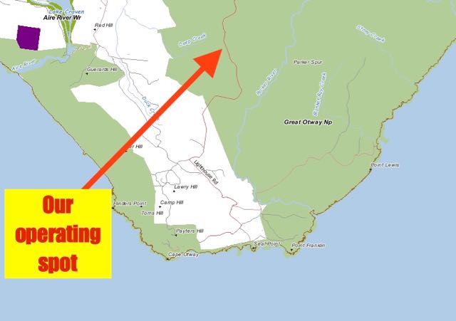
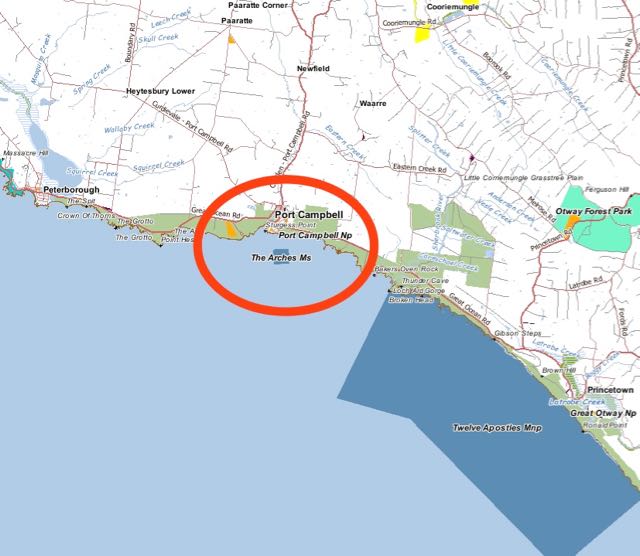
Above:- Map showing the Port Campbell National Park.  Image courtesy of Forest Explorer.

As Marija and I did not see any favourable operating spots on the eastern side of Port Campbell, we decided to head to the west along the Great Ocean Road.  We soon found Two Mile Bay Road, a dirt track leading down to Two Mile Bay.  At the end of the road is a small carpark, and this was away from the throng of tourists and made an ideal operating position.

DSC_0726

We parked the 4WD and set up my fold up table and deck chair and the operating gear just adjacent to the carpark.

Screenshot 2015-12-08 18.58.20

Above:- Map showing our operating position within the park.  Image courtesy of http://www.here.com

After setting up, Marija went for a walk down along a track from the carpark to admire the coast.  I took the same walk at the end of the activation.  You are rewarded with some very nice views of the coastline.

This slideshow requires JavaScript.

I was set up and ready to go by 9.30 a.m. Victorian local time  I tuned across the 40m band prior to putting out any CQ calls, but I was saddened to hear the band very quiet.  I was worried again that propagation was not going to be favourable.  After a few CQ calls on 7.144, Ivan VK5HS mobile came up and gave me a call and was number one in the log.   Ivan had a good strong 5/8 signal, which gave me some hope that propagation may be quite good.  Next up was Brett VK2VW (5/9 sent and 5/5 received), followed by Keith VK2PKT (5/9 both ways), and then Stef VK5HSX who was operating portable in the Lincoln National Park.

Soon after I worked John VK5BJE from the Adelaide Hills.  I was hoping to get John in the log as he desperately wanted Port Campbell to complete having worked all 45 Victorian National Parks for the Keith Roget Memorial National Parks Award (KRMNPA).  Congratulations John.

A few calls later I had my first Victorian National Park in the log.  It was Tony VK3VTH who was operating from the Coopracamba National Park, VKFF-0113.  Tony had a strong 5/8 signal and gave me a 5/9.  I was Tony’s first contact for the day.  About half a dozen calls later I was called by Ian VK1DI, and was able to give him a brand new park as well.  The band was performing quite well, with a couple of Western Australian stations calling in: Mike VK6MB and Rich VK6HRC.

I worked a total of 21 stations until things started to quieten down.  So I took the opportunity of tuning across the band.  I booked in briefly to the Riverland Radio Group Net on 7.115 and it was during this time that I heard of the terrible news of the terrorist attacks in Paris.  As I sat on my deck chair, in the sunshine, admiring the view, I thought to myself how lucky I was.  Marija and I had holidayed last year in Europe for 2 months and had spent a week in Paris.

I left the Riverland Net and found Lesley VK5LOL/3 on 7.100, calling CQ from Wyperfeld National Park, VKFF-0549.  Although Lesley was quite low down, I was very confident that she would be able to hear me.  It took a few calls, as Lesley was quite busy, but we eventually made it (5/3 sent and 5/5 received).

I then headed back up to 7.144 and started calling CQ again.  This was answered by Adrian VK5AJR in the Riverland region of South Australia, followed by Nev VK5WG in the Mid North, and then Tony VK5FTVR in Strathalbyn on the Fleurieu Peninsula.  Three stations in very different areas across South Australia, and all with good signals.  I worked a further 6 stations before it slowed down again, so I again tuned across the 40m band and heard Terry VK3WI (VK3UP) calling CQ on 7.110 from the Brisbane Ranges National Park, VKFF-0055.  Again the signal from VK3 was well down, but again I was confident that Terry would be able to hear me.  We made contact after a few calls (5/3 sent and 4/1 received).

I then made contact with husband and wife team, Joe VK3YSP and Julie VK3FOWL, who were operating portable from French Island National Park, VKFF-0622.  Again signals around VK3 were well down, but because all of the park activators were experiencing no man made noise, contacts were completed with relative ease.

Following my contact with Joe and Julie I again went back to 7.144 and worked 7 stations in VK2, VK4, VK5, and VK7.  But it again went quiet quickly again.  This afforded me another opportunity of looking across the band for park activators.  It wasn’t long before I found Mick VK3MPG calling CQ from the Little Desert National Park VKFF-0291.  This time, Mick’s signal was even lower (4/1 at best).  But we successfully made a contact even though I only received a 3/2 signal report.

I repeated the morning’s pattern and headed back to 7.144 and called CQ, and I was pleasantly surprised to be called by Cliff VK2NP who was operating with the special call of VI90IARU.  Next up was Peter VK2NEO with his normal massive signal.  I visited Peter last month during my trip to Wagga Wagga and operated from his shack and enjoyed a bite to eat and a chat.

But it soon slowed down again, with just a further 3 stations worked on 40m.  So I lowered the squid pole and removed the links in the antenna and headed to 14.310.  I worked a total of 4 stations here in Queensland and Western Australia.  Even though it was only 4 contacts, it is always pleasing to get the VK4’s and VK6’s in the log on 20m, as it can often be quite a challenge on 40m depending on the conditions and the time of the day.

The morning was getting on, and we had a few planned tourist stops before our SOTA activation later in the day.  I packed up feeling quite contented with a total of 53 contacts in the log.  And even more pleased that I was able to give a few park hunters a new park.

The following stations were worked on 40m SSB:-

  1. VK5HS/m
  2. VK2VW
  3. VK2PKT
  4. VK5HSX/p (Lincoln National Park)
  5. VK5TW
  6. VK5BJE
  7. VK5KC
  8. VK2NP
  9. VK3VTH/p (Coopracamba National Park VKFF-0113)
  10. VK5FANA
  11. VK2YK
  12. VK4RF
  13. VK4HA
  14. VK1DI
  15. VK3MRH
  16. BK2IO
  17. VK6MB
  18. VK5AKH
  19. VK6HRC
  20. VK7SA
  21. VK4GSF
  22. VK5BRL
  23. VK5MRE
  24. VK5LOL/3 (Wyperfeld National Park VKFF-0549)
  25. VK5AJR
  26. VK5WG
  27. VK5FTVR
  28. VK2HHA
  29. VK2EJW
  30. VK7LTD
  31. VK3SQ
  32. VK2RI
  33. VK2TG/m
  34. VK3WI/p (Brisbane Ranges National Park, VKFF-0055).
  35. VK3YSP/p (French Island National Park VKFF-0622)
  36. VK3FOWL/p (French Island National Park VKFF-0622)
  37. VK5JDS
  38. VK7FGGT/m
  39. VK5IS
  40. VK2MCB
  41. VK7VW
  42. VK4ARW
  43. VK2FABE
  44. VK3PMG/p (Little Desert National Park, VKFF-0291)
  45. VI90IARU
  46. VK2NEO
  47. VK7PAK
  48. VK5CZ
  49. VK1AT

The following stations were worked on 20m SSB:-

  1. VK6GLX
  2. VK4RF
  3. VK4HA
  4. VK4LS


References.

Parks Victoria, June 2014, Port Campbell National Park & Bay of Islands Costal Park

Twelve Apostles Marine National Park VKFF-0420

We had spent two very enjoyable nights in Warrnambool, and it was now time to head a little further east, to Port Campbell, where we had planned to stay for one night.  It was now day seven of our trip, and it was Friday the 13th November 2015.  Fortunately neither I, nor Marija are superstitious.  Our one and only activation planned for the day was the Twelve Apostles Marine National Park, VKFF-0955, which is situated just to the south east of Port Campbell.

Screenshot 2015-12-08 17.00.27

Above:- Map showing the location of the Twelve Apostles Marine National Park.  Image courtesy of Forest Explorer.

We departed Warrnambool and headed out east along the Princes Highway towards Allansford.  We were to take the same route as we did the day prior when we activated the Bay of Islands Coastal Park near Peterborough.  The previous day, on the way to the Bay of Islands we had seen a sign for Hopkins Fall and that night we had read that they were worth detouring for a look.  So that’s exactly what we did.

Hopkins Falls are located just to the north east of Warrnambool.  Take Staffords Road off Princes Highway, and then travel east along St Marys Road.  As we drove along the country roads in this area, we noted that it was very flat and we certainly didn’t picture any waterfalls to be in the area.  But we were pleasantly surprised to find Hopkins Falls.  And there was even some water flowing over the falls which are about 90 metres wide and about 11 metres in height.  A number of species of fish are found in the Hopkins River, including River Blackfish and eels.

We then headed back to the Highway and then took another detour to the south, and headed down the Childers Cove Road to Childers Cove, Sandy Cove, and Murnanes Bay.  There are a number of ships which have come unstuck along this coast, and one of those is the Children, which was a 255 ton wooden barque, built in Liverpool England in 1824.  During her 1839 voyage, the Children was caught in hurricane force north westerly winds.  Upon the winds surviving, the Captain, went below to sleep and left the Second Mate in charge, as the First Mate had become unwell.  The Captain himself, had not slept for four days.  Sadly, there was a misjudgement of distance from the mainland, and during the night, the Children struck a single rock, known as Needle Rock, that stood in the eastern part of Childers Cove.  The Children soon broke apart and those on board were washed away.  A number of the crew and passengers drowned, however a number did survive.  By daylight of the next day, the survivors were huddled together on the beach, amid the bodies of the deceased and the carcasses of animals washed ashore that had been on the ship.  One of the survivors, whose foor had been smashed by an anchor when the deck gave way, had a toe amputated with a knife as he lay on the beach.  Surprisingly, Childers Cove is not named after the ship, but is in fact named after H.C.E. Childers, the founder of the University of Melbourne.

We then drove back to the Highway again and continued east, stopping briefly for a photo at Nullawarre.  This is the first, or last, town on the Great Ocean Road, depending upon which way you are travelling of course.  Nullawarre is located in prime dairying and grazing country, and consists of a public hall, a post office, a store and a school which services the wider district.

DSC_0576

We had also seen the day before, the sign for the historic Boggy Creek Hotel, so we again ventured off the Highway and headed into Boggy Creek.  Unfortunately the pub was shut, but there appeared to be a nice little area out the back, which would be nice to sit in on a warn day under the shade.  At the front of the hotel is a small plaque which states that it was here that Customs Detective Inspector John Christie, often in the disguise of a tinsmith, took refuge when on his many walks seeking information about whiskey stills in the area.  Christie has a very interesting past and more about him can be found here…..

http://adb.anu.edu.au/biography/christie-john-mitchell-5589

It was back to the Highway and on to the Bay of Martyrs which is part of the Bay of Islands Coastal Park.  We then drove through the little town of Peterborough.  We took a brief stop to have a look at the memorial plaque and anchor for the Falls of Halladale, which was a barque which was wrecked in thick fog off the coast in 1908.

We then headed inland again, toward the little town of Timboon.  We stopped off at the Timboon Cheesery to try some of the local wares.  This is part of the 12 Apostles Gourmet Trail.  You can collect a brochure of the trail from most of the local tourist outlets.  The staff here were very friendl, and Marija and I, and two English tourists enjoyed some cheese tasting.  This is well worth a visit, and we walked away with quite a few dairy products.

We continued on to Timboon and had lunch at the Timboon Railway Shed Distillery.  There is a licenced restaurant here, and of course, they distill their own whisky and spirits, including Coffee Crea, Strawberry Schnapps and a premium Vodka.  I could have stayed here all day!

http://www.timboondistillery.com.au/

We headed back to the coast and stopped off at London Bridge and The Grotto.

The Grotto is a sinkhole geological formation.  Wooden steps wind down the cliff face to the bottom.  It is a very easy walk down and well worth a look.

London Bridge, also known as London Arch is an offshore natural arch formation.  It previously formed a complete double span natural bridge.  On the evening of 15 January 1990, the main arch connecting London Bridge to the mainland cracked and fell into the sea.  Fortunately no-one was injured.  However, two people were marooned on the new island and needed to be rescued a number of hours later by helicopter.

Our next brief stop was the lookout on the Great Ocean Road, just above Port Campbell.  It affords nice views of this quaint little tourist town and the surroundying countryside and coast.

After arriving in Port Campbell, we booked in to our accomodation, which was the Port Campbell Parkview Motel and Apartments.  Again, very friendly staff, and very nice clean rooms.

After some debate in the motel room, we decided to head out to 12 apostles Helicopters and take a scenic flight along the coastline.  The place was packed!  There were hundreds, probably thousands of tourists, as this is also the area where you take the tunnel under the Great Ocean Road, leading to the Twelve Apostles.  And the line up for the helicopter flights was certainly very large.  We were told we would only have to wait 20 minutes, but this blew out to about 90 minutes.  But it was well worth the wait.  The flight was amazing and puts the area into a totally unique perspective.  We flew from just the other side of the Twelve Apostles, all the way down to the Bay of Islands, and return.

http://www.12apostleshelicopters.com.au/

This slideshow requires JavaScript.

After our helicopter flight we drove south east on the Great Ocean Road, seeking a suitable spot for the park activation.  This is a very very busy part of the Great Ocean Road, and suitable places to operate from where very limited.  We chose a little carpark off the Great Ocean Road, a little to the north west of Princetown Road.

For this activation I ran the Yaesu FT-857d, 40 watts and the 20m/40m linked dipole supported on the 7 metre telescopic squid pole.  Upon turning on the radio, I was very disappointed to hear extremely strong static crashes.  But I headed to 7.144 which was my nominated operating frequency, and commenced calling CQ.  It wasn’t long before I was called by John VK5BJE with a beautiful 5/9 signal from the Adelaide Hills.  This was followed by Dennis Vk2HHA, who has become a regular park hunter, followed by Ron VK3MRH.  Ron too, has become a regular WWFF park hunter of late.  A good steady flow of callers followed, from VK2, VK3, VK4, and VK5.

After about 20 minutes in the park, another vehicle pulled in to the carpark and out hopped the car’s occupants.  As I looked up to see who it was, I thought to myself that the driver looked very familiar.  But I was in the middle of a mini pile up so I was trying to concentrate on the callers.  It turned out that it was Nick VK3ANL and his lovely wife, and Nick’s parents from Queensland.  What a surprise.  My second unexpected amateur visitor during the trip.  We had a good chat and arranged to have dinner together later that night at the Port Campbell Hotel.

This slideshow requires JavaScript.

After Nick had left I headed back to 7.144 where there was quite a large pile up of park hunters waiting to get the Twelve Apostles in their logbook.

After Nick left I went back to 7.144 and there was a string of patient park hunters waiting there for me.  I went on to work a further 26 stations in VK1, VK2, VK3, VK5 and VK7.  All signals were very good, and the band was completely devoid of man made noise.  The only noise which I did have to put up with was the static crashes and the sound of a number of Hells Angels roaring passed me on the Great Ocean Road.  I also picked up another South Australian National Park, after working Stef VK5HSX who was operating portable from the Lincoln National Park near Port Lincoln on the Eyre Peninsula.

After working a total of 49 stations on 40m, and having qualified the park, I decided to have a listen on 20m.  It was just 4.00 p.m. Victorian Local time (0700 UTC), and I was hoping that there might be a little bit of Long Path Europe activity on 20m.  I immediately headed to 14.310 and started calling CQ and this was answered by Rick VK4RF/VK4HA with a strong 5/9 plus signal.  Rick was kind enough to post me on the DX cluster, which resulted in a handful of calls from Europe, New Zealand, and Australia.  But it was still a little early, and the band had not yet opened up.  I did manage to work Italy, Germany, New Zealand, Estonia, and France.

As it was getting a little late, and we planned to go out for tea that night, I headed back to 40m to see if I caould pick up any last desperados.  Unfortunately there was a lot of activity around 7.144, so I headed down the band a little and called CQ on 7.135.  My first taker was Andrew VK5PZ, followed by Alan VK7AN, and then Geoff VK5HEL in Murray Bridge.  I worked just a further 4 stations in VK2, VK3, VK5, and VK7, before going QRT.

This was a very successful activation, with a total of 69 contacts in the log on 40m SSB and 20m SSB.  And a brand new VKFF park for me towards my VKFF activation tally.

The following stations were worked on 40m SSB:-

  1. VK5BJE
  2. VK2HHA
  3. VK3MRH
  4. VK3PMG
  5. VK5FTVR
  6. VK5FANA
  7. VK3TKK/m
  8. VK4RF
  9. VK4HA
  10. VK5TN
  11. VK3YAR
  12. VK3VBI
  13. VK3FTAD
  14. VK5KC
  15. VK5HYZ
  16. VK3FQSO
  17. VK3BY
  18. VK3VTH/m
  19. VK5HCF
  20. VVK5FLEX
  21. VK5KLV
  22. VK2IO/m
  23. VK2VW
  24. VK2NP
  25. VK5FMID
  26. VK5ZGY
  27. VK5NRG
  28. VK4AAC/5
  29. VK3VLY
  30. VK3PF
  31. VK5DJ
  32. VK5WG
  33. VK1DI
  34. VK3KRH
  35. VK3HRA
  36. VK1AT
  37. VK5HS
  38. VK7LTD
  39. VK3FSPG
  40. VK2PKT
  41. VK5EE
  42. VK3VT
  43. VK3FEUG
  44. VK3PAT
  45. VK3DBP
  46. VK5HSX/p (Lincoln National Park)
  47. VK5PL
  48. VK7PSJ
  49. VK3OHM
  50. VK5PZ
  51. VK7AN
  52. VK5HEL
  53. VK5JK
  54. VK3XPT/m
  55. VK6FGGT
  56. VK2XXM

The following stations were worked on 20m SSB:-

  1. VK4RF
  2. VK4HA
  3. IZ8EFD
  4. I5FLN
  5. DL2ND
  6. ZL4KD
  7. VK4EDD
  8. IZ2SDK
  9. ES5QD
  10. DK0EE
  11. IK2VUC
  12. F1BLL
  13. IW2NXI

We headed back to the hotel and freshened up a bit and then went to the Port Cambell Hotel, where we met up with Nick and his family, and enjoyed a good meal and good company.


References.

Flagstaff Hill Maritime Village, 2015, <http://www.flagstaffhill.com/media/uploads/Wrecks-Children.pdf&gt;, viewed 8th December 2015

Victorian Places, 2015, <http://www.victorianplaces.com.au/nullawarre&gt;, viewed 8th December 2015

Wikipedia, 2015, <https://en.wikipedia.org/wiki/London_Arch&gt;, viewed 8th December 2015

Bay of Islands Coastal Park, VKFF-0743

Our one and only planned portable activation for Thursday 12th November 2015, was the Bay of Islands Coastal Park, VKFF-0743.  I had planned to activate this park in the morning, but we changed the activation to the afternoon.  Instead of sitting in the park, on Thursday morning we went to the Flagstaff Hill Maritime Village, which is set on 10 acres in Warrnambool and relects the pioneering atmosphere of an 1870’s coastal port.  It features a number of buildings from that era.  We highly recommend a visit here if you are in Warrnambool.

For more information on Flagstaff Hill, please have a look at…..

http://www.flagstaffhill.com/

After spending all morning and a bit of the afternoon at Flagstaff Hill (including an excellent lunch), we then headed off to have a look at Thunder Beach, and Logans Beach just outside of Warrnambool.  Logans Beach is a recognised whale nursery, although it was the wrong time of the year to view any whales.  We also visited ‘Granny’s Grave’ which marks the burial site of Agnes Ruttleton, who died in December 1848.  She was known as Granny, and was recorded as the first white woman to be buried in Warrnambool.  An interesting fact indeed.  But not what makes this grave and headstone unusual.  So, what does?  The headstone is marked with the name of Mrs James Raddleston.  In fact for many years, it was believed that this was the resting place of a Mrs Raddleston.  Not so!  Ruttleton’s husband was incorrectly named as a James Raddleston, and therein lies the mistake.

For more information on this very interesting story, please have a look at……

http://www.bluestonemagazine.com.au/2014/02/09/who-is-the-granny-behind-grannys-grave/

We then headed out of Warrnambool to Allansford Cheese World, situated on the Great Ocean Road.  It is owned and operated by the Warrnambool Cheese & Butter Factory, and is the cellar outlet for their cheese range.  This is a great set up, with various products on sale and cheese tastings.  There is also an excellent cafe here and a small museum.  This is another place that we highly recommend a visit to if you are in the area.

http://www.cheeseworld.com.au/Home

After leaving Cheese World, we continued along the Great Ocean Road, through the little areas of Mepunga West, Meppunga East, Nullawarre, Nirranda, and Nirranda South, towards the town of Peterborough, and our ultimate destination, the Bay of Islands Coastal Park.

The Bay of Islands Coastal Park protects a total of 950 hectares of fragile coastal vegetation, unique wildlife, and off-shore islands and rock stacks.  The rock stacks provide a colony of Silver Gulls safe nesting sites from predators such as foxes and cats.  Other stacks are home to Victoria’s only marine cormorant, the rare Black-faced Cormorant.

I had checked out some maps prior to leaving Warrnambool and I figured the easiest way of accessing the park was off the Great Ocean Road.

Screenshot 2015-12-04 16.24.12

Above:- Map of Victoria showing the location of the park.  Image courtesy of Forest Explorer.

Subsequent checks on maps, show that you can access the park, closer to Warrnambool, via Childers Cove Road.


Screenshot 2015-12-04 16.23.45

Prior to activating we stopped briefly at the Bay of Islands viewing plattforms, to admire the view of this amazing coastline.  There are some easy paths here leading from the carpark, to a number of timber viewing platforms.

This slideshow requires JavaScript.

The area was very busy with tourists, so we wanted to find a location that was out of the way.  After driving up and down the Great Ocean Road, we found a little dirt track running south off the Great Ocean Road.  At the end of this was a small carpark.  And there were no tourists!  It was ideal.  We parked the 4WD and walked a short distance up onto a small cliff face which overlooked Massacre and Crofts Bay.  It was an idealic location.

Screenshot 2015-12-04 16.23.28

After setting up I headed for 7.144, but found it was busy.  Rob VK4AAC/5 was activating a park in the South East of South Australia.  Although he was unreadable to me, I could clearly hear all of the park hunters.  So I QSY’d down to 7.139 and started calling CQ.  This was answered by Ian VK5KKT, north of Adelaide, with a strong 5/9 signal.  This was followed by the ever keen Rick VK4RF/VK4HA who had a good 5/7 signal coming in to the Bay of Islands.  Next up was Adrian VK5FANA at Arthurton on the Yorke Peninsula who had a strong 5/8 signal.

Signals were very good, but it was extremely noisy on the 40m band with S9+ static crashes.  Amazing really as I was bathed in bright sunshine in the park.  But clearly, the weather was unstable somewhere.

I had a steady flow of callers, but soon started to experience some QRM from VK2JE on 7.138 who was working into ZL.  I battled with the QRN and the QRM, and then decided it was just too bad.  So I QSY’d down to 7.130.  But no before working Stef VK5HSX who was operating portable from the Yeldulknie Conservation Park on the Eyre Peninsula, west of Adelaide.

After QSYing to 7.130, my first contact there was with Brett VK2VW, who has become a regular park hunter.  This was followed by Warren ZL2AJ in New Zealand with a very strong 5/9 signal.  I went on to work a further 12 stations in VK2, VK5, and VK7.  This included Gerard VK2IO who was mobile (5/8 sent and 4/7 received), and Steve VK2DDV who was running QRP 3 watts.

Whilst operating I saw a 4WD pull up into the carpark, and a gentleman started walking towards me.  It turned out to be Bill VK3LY from Nhill in western Victoria.  Bill was travelling down the Great Ocean Road and looking for a spot to camp for the night, and he had stumbled across me.  Amazing who you bump into, in the middle of nowhere!

DSC_0559

Bill and I had a good chat for about 10 minutes, and I then lowered the squid pole and removed the links and tried my luck on 20m.  I called CQ on 14.310 and this was immediately answered by Rick VK4RF/VK4HA with a strong 5/9 signal.  This was followed by Luc ON4BB in Belgium, followed by Luciano I5FLN in Italy, and then Sergey RA3PCI in Russia.  However signals on the long path into Europe were well down.

I worked a further 4 stations on 20m, in New Zealand and Spain, before heading back for some final calls on 40m.  After returning to 7.144 on 40m, I managed just 3 more contacts into VK2, VK4, and VK7.  It was starting to get late, and we had booked tickets to attend the ‘Shipwrecked’ sound and laser show at the Flagstaff Hill Maritime Village that night.

I had qualified the park, and had a total of 46 contacts in the log.

The following stations were worked on 40m SSB:-

  1. VK5KKT
  2. VK4RF
  3. VK4HA
  4. VK5FANA
  5. VK5BJE
  6. VK7XX
  7. VK5PL
  8. VK7CW
  9. VK2NP
  10. VK5WG
  11. VK5AKH
  12. VK7VAZ
  13. VK2NEO
  14. VK2HHA
  15. VK3MRH
  16. VK2PGB
  17. VK5IS
  18. VK5CZ
  19. VK2FABE
  20. VK5HSX/p (Yeldulknie CP)
  21. VK2VW
  22. ZL2AJ
  23. VK2IO/m
  24. VK2HJ
  25. VK5HS
  26. VK5NRG
  27. VK5KLV
  28. VK7CL
  29. VK5KPR
  30. VK5FTVR
  31. VK2DDV
  32. VK5BWH
  33. VK2FDAV
  34. VK2JLS
  35. VK7FRJG
  36. VK2QV
  37. VK4MWG

The following stations were worked on 20m SSB:-

  1. VK4RF
  2. VK4HA
  3. ON4BB
  4. I5FLN
  5. RA3PCI
  6. ZL4KD
  7. ZL3YF
  8. EA7BA
  9. EA5IKJ

After packing up we headed back into Warrnambool and to the motel where we freshened up and then headed off to the Flagstaff Hill Maritime Village for their sound and laser show, which was truly amazing.


References.

Parks Victoria, 2015, <http://parkweb.vic.gov.au/explore/parks/bay-of-islands-coastal-park&gt;, viewed 4th December 2015