DX World Award

QRZ.com offer a number of different awards.  Each certificate costs around the @20.00 dollar mark for QRZ subscribers and $25.00 for non subscribers.  A few weeks ago I applied for the DX World Award which is issued for successfully making contact with at least one hundred different countries.

dx-world-award

Planned talks on the WIA

image_1_hires.jpg

Following on from our recent trip around South Australia, fellow WIA Director Andrew VK6AS and I have the following talks planned on current issues surrounding the Wireless Institute of Australia (WIA):

  • Perth, WA.
    • 2.30 p.m. Saturday 22nd October 2016
    • Bassendean Seniors & Community Centre, 50 Old Perth Road, Bassendean WA
  • Albury/Wodonga area
    • Monday 14th November 2016.
    • venue/time to be announced.
  • Frankston & Mornington Peninsula Amateur Radio Club (FAMPARC).
    • 2.00 p.m.  Tuesday 15th November 2016
    • FAMPARC clubrooms, located at the south side of the school grounds of Cornish College, Patterson Lakes/Bangholme, VIC
    • 12.30 p.m. BBQ (sponsored by Gippsland Gate Radio Electronics Club) followed by the talk.
  • Eastern & Mountain Districts Radio Club (EMDRC)
    • 8.00 p.m. Tuesday 15th November 2016
    • EMDRC clubrooms, located at 13a McCubbin Street, Burwood, VIC
    • 6.30 p.m. BBQ, followed by the talk
  • Geelong Amateur Radio Club
    • 10.30 a.m. Wednesday 16th November 2016
    • Geelong ARC clubrooms, Storrer Street, Geelong, VIC

We hope to get to other States, finances and time pending.

Loch Luna Game Reserve VKFF-1723

Day three of our trip was Thursday 13th October, 2016, and this involved a 265 km drive back to Adelaide from the Riverland.  Andrew and I were very pleased with the way our talks on the WIA were received in Mount Gambier and the Riverland.

screen-shot-2016-10-13-at-7-23-09-pm

Above:- Map showing our route from Barmera in the Riverland, to Adelaide, and then back to Mount Barker for me.  Map courtesy of plotaroute.com

Andrew and I had planned to activate the Moorok Game Reserve, but as we drove along the Sturt Highway we saw the sign for the Loch Luna Game Reserve, and decided that Loch Luna would be our park for the morning.  Loch Luna Game Reserve VKFF-1723 is situated about 225 km north east of Adelaide and about 3 km west of Barmera.

screen-shot-2016-10-14-at-10-05-12-am

Above:- Map showing the location of the Loch Luna Game Reserve in the Riverland region of S.A.  Map courtesy of Protected Planet.

Loch Luna Game Reserve if about 2,059 hectares in size and comprises a range of water bodies including narrow creeks and shallow swamps.  This habitat provides an important habitat for numerous aquatic birds and native mammals.  The rare White Bellied Sea Eagle can be located in the park.

The park was proclaimed on the 7th November 1985 with exception to a parcel of land known as Sugarloaf Hill within the boundaries of the game reserve which has been excluded from protection for the purpose of mining activity.

The park is a game reserve and the hunting of waterfowl is allowed in the reserve, but only on declared days.

The main entrance to the reserve is near Nappers Bridge on the western side of Lake Bonney, about 10 kilometres from Barmera.  But Andrew and I headed to an area of the park called the Kaiser Strip.  It is a small section of the park, over the Kingston Bridge, opposite the town of Cobdogla.  We found a small cleared area alongside the Murray River, and it was here that we established the station which consisted of the Yaesu FT857d, 40 watts and the 20/40/80m linked dipole.

screen-shot-2016-10-14-at-10-02-34-am

Above:- Aerial shot of the park showing our operating spot.  Image courtesy of Protected Planet.

I started off on 40m and started calling CQ on 7.144.  It was incredibly slow going.  Not surprising as we had not advertised on parksnpeaks our intentions.  But eventually I had a responder to my CQ calls.  My first contact was with Trent VK7HRS, followed by Kevin VK3CKL, and then Peter VK3PF.  Once I had my 10 contacts in the log I handed the mic to Andrew.

Directly opposite us on the other side of the river was the nest of a Whistling Kite, high atop a dead gum tree on the edge of the river.  Whistling Kites are a medium sized raptor bird of prey.  During our activating we were rewarded with the call of the birds which is a clear descending whistle which is often followed by a rapid series of rising notes.

I took the opportunity of photographing some other birds I observed in the park, whislt Andrew was on air.  They included Crimson Rosellas, WHite Plumed Honeyeaters, Pelicans, Spoonbills, and Cormorants.

Other than 40m, Andrew put out a number of calls on 80m but we had no takers.  During our activation the local ranger arrived and we had a quick chat about amateur radio.  He advised that he had found amateurs in parks previously in the Riverland region, and he was aware of the parks program.

It was time to pack up and get back into Adelaide, and drop Andrew off at the airport.  I will go back to this park in the near future to pick up the remaining contacts to add towards the 44 required QSOs to qualify the park.

Thanks to Mick VK3GGG, Col VK5HCF, and Peter VK3PF for spotting us on parksnpeaks.

I worked the following stations on 40m SSB:-

  1. VK7HRS
  2. VK3CKL
  3. VK3PF
  4. VK3GGG
  5. VK3PMG
  6. VK1DI
  7. VK7CW
  8. VK5EE
  9. VK2CPR/m
  10. VK3VEF


References.

Department for Environment and Heritage, 2009, ‘Parks of the Riverland’

Wikipedia, 2016, <https://en.wikipedia.org/wiki/Loch_Luna_Game_Reserve&gt;, viewed 14th October 2016

A talk in the Riverland and Peebinga Conservation Park

Day two of our road trip was Wednesday 12th October 2016 and this involved a 451 km drive from Mount Gambier in the south east of South Australia to Barmera in the Riverland region.  This took Andrew and I along the Riddoch Highway through the wine growing region of the Coonawarra to Narracoorte, and then along the Narracoorte Road through Western Flat to Bordertown.  From there we took the Ngarkat Road which dissects the extremely large and remote Ngarkat Conservation Park.

Screen Shot 2016-10-13 at 7.22.12 pm.jpg

Above:- Map showing our route on day two, from Mount Gambier to Barmera,  Map courtesy of plotaroute.com

As mentioned this is quite a remote area, and as you travel through the 270,000 hectare Ngarkat Conservation Park, all you can see for miles and miles is the mallee scrub of the park.  To put this into perspective, Luxembourg in Europe could fit into the park quite comfortably.

dsc_3043

After a brief stop at the Pinnaroo bakery for some lunch we continued north on the Browns Well Highway, following the South Australian/Victorian State border just to our east.  Prior to reaching our intended destination of Barmera, Andrew and I agreed we would stop off at the Peebinga Conservation Park 5CP-173 and VKFF-0830 and activate the park.

Screen Shot 2016-10-14 at 9.49.01 am.jpg

Above:- Map showing the location of the Peebinga Conservation Park, near the SA/VIC State border.  Map courtesy of Protected Planet.

I had activated Peebinga twice previously.  The first being in November 2013, and then again in November last year following the park being added to the World Wide Flora Fauna (WWFF) program.  Sadly on that occasion I had not reached the 44 QSO threshold required to qualify the park for the global WWFF program.  So I was keen to pick up a few more QSOs to get over the line.

For information and photos on my previous activations, have a look at the following links…..

https://vk5pas.org/2013/11/18/peebinga-conservation-park/

https://vk5pas.org/2015/11/22/peebinga-conservation-park-vkff-0830/comment-page-1/

Andrew and I set up near the intesection of Browns Well Highway and Kringin Road, in the north eastern corner of the park.

Screen Shot 2016-10-14 at 9.48.33 am.jpg

Above:- Aerial shot of the park showing our operating spot in the north eastern corner.  Image courtesy of Protected Planet.

Peebinga Conservation Park is about 3,400 hectares in size and is located abut 240 km east of Adelaide and just 10 km west of the South Australian/Victorian State border.  The park was originally used for agriculture but was eventually gazetted as a park to preserve the habitat of the rare Western Whipbird which is now believed to be locally extinct.  The park has been identified by BirdLife International as an Important Bird Area (IBA) as it supports a large population of Malleefowl.

Vegetation within the park varies as some of it has been cleared and remains grassland.  The remainder of the park is characterised by low stabalised sand dunes with opern scrub featuring Ridge-fruited and Seldner-leaved Mallee with Warty Cypress over Broom Bush.  The higher areas of the park have Square-fruited, Red-fruited, Red and White Mallee.  Over 150 different native flora species have been recorded in the park, with 14 of those being of conservation significance.

We set up close to the old railway line which once passed through this area of South Australia.  The Peebinga railway line was opened on 28th December 1914 and ran east for a distance of 106km, from Karoonda and terminated at Peebinga, just 2 km from the Victorian State border.  The line was closed on 7th December 1990.  The cost of construction of the line was £207,000 plus £56,690 for rolling stock

I started off calling CQ on 7.144 and first contact in the log was Col VK5HCF, followed by Dennis VK2HHA and then Mick VK3GGG/VK3PMG.  Despite no warning given of the activation, and the fact that it was a workday, we soon had a steady flow of callers from VK1, VK2, VK3, and VK5.  I logged a total of 21 stations and then handed the mic over to Andrew.  The novel contact of the afternoon for me was with Adrian VK2ALF who was bicycle mobile.

After Andrew had qualified the park I put out a few final 40m calls and logged a further 7 contacts.  We then lowered the squid pole and removed the links and headed to 3.610 on 80m.  Andrew made a total of  contacts there, but conditions were quite difficult.  To conclude the activation, we put out a few CQ calls on 20m, but sadly had no callers there.

The flies were certainly out in force during our activation at Peebinga.

dsc_3050

Thanks to Mick VK3GGG, Col VK5HCF, and Peter VK3PF for spotting us on parksnpeaks.

I worked the following stations on 40m SSB:-

  1. VK5HCF
  2. VK2HHA
  3. VK3GGG
  4. VK3PMG
  5. VK3BBB
  6. VK3PAT
  7. VK3SQ
  8. VK3MCK
  9. VK5EE
  10. VK5DK
  11. VK3PF
  12. VK5FMID
  13. VK3MCD
  14. VK3VBI
  15. VK3VM/5
  16. VK2NEO
  17. VK5KLV
  18. VK5NM
  19. VK2IO
  20. VK2FADV
  21. VK2ALF/m (bicycle mobile)
  22. VK2JAZ
  23. VK2GAZ
  24. VK3MRH
  25. VK3FARO
  26. VK1AT
  27. VK5VRB
  28. VK5AKG

References

Department of Environment and Natural Resources, 2011, Reserves of the Billiatt District Management Plan 2011

Mallee Highway Touring Route, 2016, <http://www.malleehighway.com.au/html/parks-sa-mallee.html#peebinga&gt;, viewed 14th October 2016

Wikipedia, 2016, <https://en.wikipedia.org/wiki/Peebinga_railway_line&gt;, viewed 14th October 2016

A trip to the South East and Mount Monster

On Tuesday morning (11th October 2016) Andrew VK6AS and I were on the road by 8.30 a.m. and on our way to Mount Gambier.  We had a scheduled talk that evening at the clubrooms of the South East Radio Group (SERG).  Our talk the previous night at the Blackwood Community Centre, hosted by AHARS, attracted around 100 amateurs from most of the Adelaide metropolitan clubs.

It was a 404 km trip ahead of us and we had decided to activate a park along the way and introduce Andrew to the wonderful world of park activating.  However, the weather was not on our side.  It was drizzling with rain.

Screen Shot 2016-10-13 at 7.20.57 pm.jpg

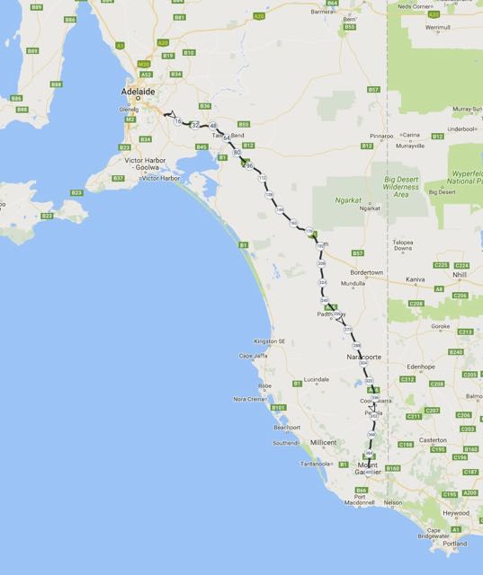
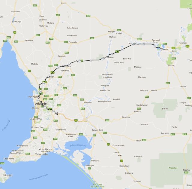
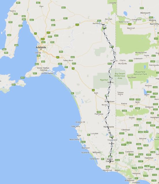
Above:- Map showing our route for the day, down to the South East of South Australia.  Map courtesy of plotaroute.com

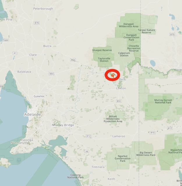
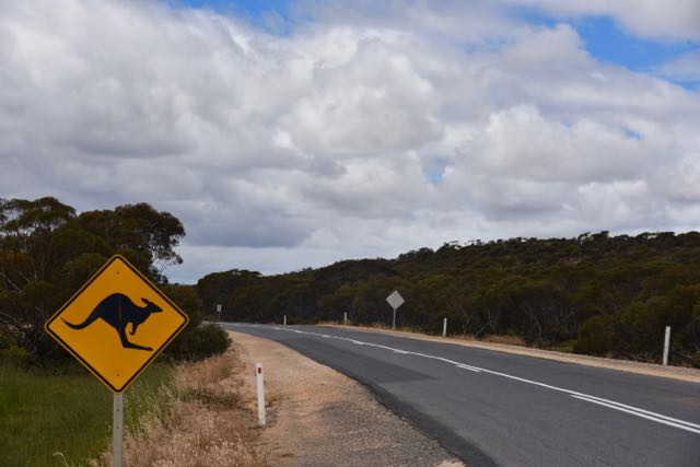
As we headed further south east, the weather behind us appeared to be quite clear.  But ahead of us, the sky was quite black, and light showers accompanied us for most of the drive.  I decided to take Andrew to the Mount Monster Conservation Park 5CP-149 and VKFF-0800.  Mount Monster is situated around 13 km south of the town of Keith on the Naracoorte/Keith Road (Riddoch Highway).

Screen Shot 2016-10-13 at 7.26.35 pm.jpg

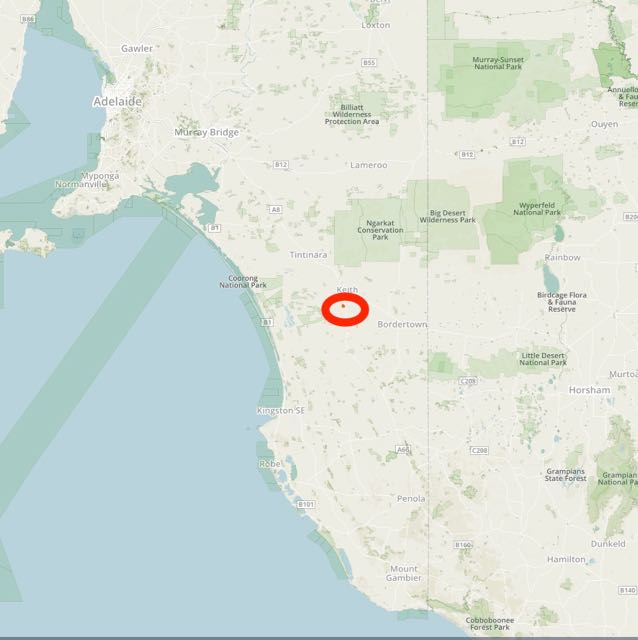
Above:- Map showing the location of the Mount Monster Conservation Park.  Map courtesy of Protected Planet.

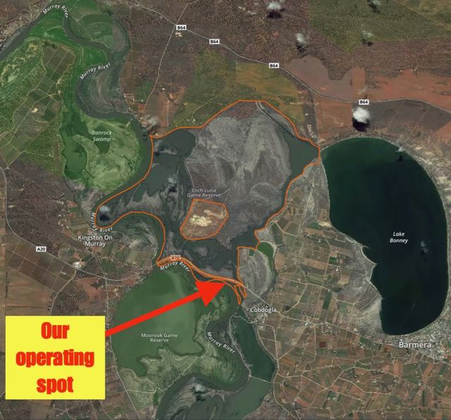
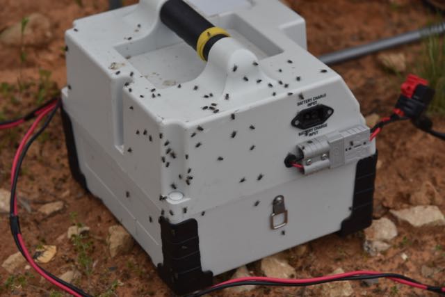
The park is well signposted on the Highway and is just a short drive down Mount Monster Road, which is dirt but in good condition.  As we pulled in to the park, the showers eased a little much to our pleasure.  We headed for the main parking area, where the track takes you to Mount Monster peak.  We set up the fold up table and the deck chair, and ran my Yaesu FT-857d set at 40 watts, and a 20/40/80m linked dipole, supported on a 7m heavy duty telescopic squid pole.

screen-shot-2016-10-13-at-7-26-11-pm

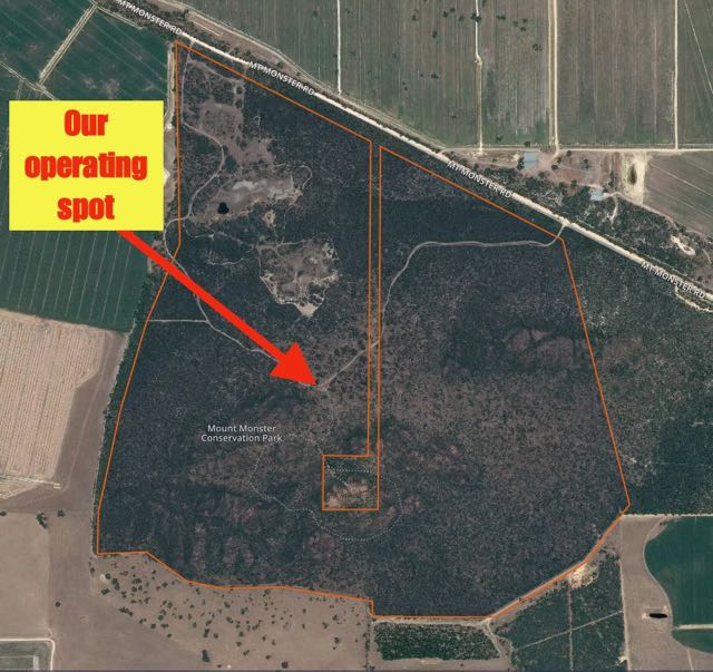
Above:- Aerial shot of the Mount Monster Conservation Park showing our operating spot within the park.  Image courtesy of Protected Planet.

Mount Monster Conservation Park is around 95 hectares in size and was dedicated as a Conservation Park in September 1976.  The park was originally donated to the South Australian State Government by the Buddle, Ellis and Davis families.  The park is noted for the Mount Monster summit, a granite outcrop with rises to a height of 93 metres above sea level.  Sadly not a SOTA summit as it does not have the required prominence of 150 metres.  Despite it not being the highest summit in the world, Mount Monster offers some terrific views from the trig point.  We did not climb to the top on this occasion due to time constraints.

Around 176 different plant species have been recorded in the park, including 30 different types of orchids.  One of those, Cradle of Incense is considered to be nationally endangered.   The main vegetation located in the park is Blue gum woodland, pink gum/melaleuca woodland, peppermint box/mallee woodland, golden/prickly wattle shrublands, and broombush heath.  Sheoaks, banksias and hakeas are also located in the park.  The park also protects the endangered monarto mintbush which is found naturally only in two regions of South Australia: at Mount Monster, and also as the name suggests, at Monarto.

The park is home to a wide variety of native wildlife including kangaroos, wallabies, and echidnas.  Birdlife here is also plentiful as we found out.  Galahs, wrens, and a large number of Red rumped parrots were seen during our visit.

The former Gold Escort route passes through Mount Monster Conservation Park.  This is the route that was used to bring gold from the Victorian goldfields into South Australia.  Commissioner Alexander Tolmer led the first of 18 police escorts of gold between March 1852 to December 1853.  A total of 528,509 ounces of gold were conveyed along this route.

1405222203_w1.png

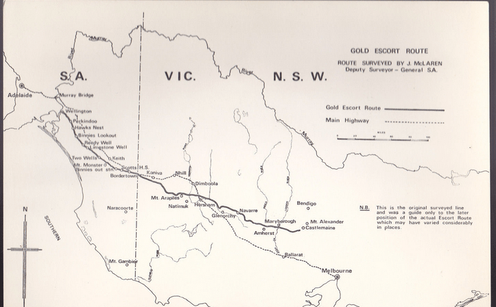
Above:- Map showing the Gold Escort route from Victoria into South Australia.  Image courtesy of http://www.prospectingaustralia.com

I had been to the park previously, but this was prior to Mount Monster being added to the World Wide Flora & Fauna (WWFF) program, so I was keen to get my 10 contacts to qualify the park for the Australian (VKFF) chapter of the program.  But it was unlikely that I would have sufficient time to get the required 44 contacts to qualify the park for the global program.  I started off, calling CQ on 7.144 on 40m, and first in the log was Brian VK3BBB.  This was followed by Ken VK3UH, Dennis VK2HHA and then Scott VK7NWT.  All had 5/9 signals to Mount Monster.

After I had my ten contacts in the log I handed the mic over to Andrew.  This was Andrew’s first ever park activation.  Andrew had soon reached his required quota of 10 contacts as well, and had qualified the park.    I worked a further 5 stations on 40m, before we lowered the squid pole and removed the links in the dipole for 80m.

Andrew worked a total of 8 stations on 80m in the Adelaide Hills, the Murraylands region of SA, western Victoria, and Mount Gambier.  On 80m for me I spoke with John VK5BJE, Brian VK5FMID, and Adrian VK5FANA.  We also put a few calls out on 14.310 on 20m but sadly had no takers there.

Fortunately the rain had held off during our activation.  But time was marching on and we were keen to get to Mount Gambier, so it was away with the gear and back on the road.  I had a total of 18 contacts in the log, which means another trip back to this park to pick up the remaining 26 contacts required for the WWFF global program.

Many thanks to Adrian VK5FANA for spotting us on parksnpeaks.

I worked the following stations on 40m SSB:-

  1. VK3BBB
  2. VK3UH
  3. VK2HHA
  4. VK7NWT
  5. VK5BJE
  6. VK3PF
  7. VK3OHM
  8. VK7LTD
  9. VK3FT
  10. VK7FAMP
  11. VK3GGG
  12. VK3PMG
  13. VK5FANA
  14. VK5FMID
  15. VK5EE

I worked the following stations on 80m SSB:-

  1. John VK5BJE
  2. Brian VK5FMID
  3. Adrian VK5FANA


References

Department of Environment and Natural Resources, 1997, Mount Monster Management Plan.

Friends of Parks South Australia, 2016, <http://www.friendsofparkssa.org.au/members-directory/friends-of-mount-monster&gt;, viewed 13th October 2016

Sydney Morning Herald, 2016, <http://www.smh.com.au/news/South-Australia/Keith/2005/02/17/1108500204330.html&gt;, viewed 13th October 2016

A trip around South Australia with Andrew VK6AS

On Monday afternoon (10th October 2016) I headed down to the Adelaide Airport and collected fellow Wireless Institute of Australia (WIA) Director Andrew VK6AS.  Andrew and I had scheduled 3 talks over the next 3 days across South Australia with regards to matters involving the WIA.

On Monday evening we spoke at the Blackwood Community Centre, Young Street Blackwood, to around 100 amateurs.  The evening was hosted by the Adelaide Hills Amateur Radio Society and was attended by members from most of the Adelaide suburban clubs.

On Tuesday morning (11th October 2016) Andrew and I drove down to Mount Gambier, a journey of around 404 km.  On the way down to Mount Gambier I introduced Andrew to park activating.  Despite the rather inclement weather, we activated the Mount Monster Conservation Park VKFF-0800.  On arrival in Mount Gambier we headed to the home of Col VK5HCF for a coffee and a chat and later that evening we joined Col VK5HCF and the President of the South East Radio Group (SERG) Col VK5DK, at one of the local hotels for dinner.  We subsequently spoke with a group of 18 amateurs from VK5 and VK3 at SERG’s clubrooms in Mount Gambier.

On Wednesday morning we were on the road again, and this time headed to the Riverland region of South Australia.  This was a 451 km drive.  Along the way we briefly activated the Peebinga Conservation Park VKFF-0830.  That evening we spoke with around 12 amateurs at the Barmera Scout Hall.

On Thursday morning (12th October 2016) Andrew and I headed back to Adelaide.  Along the way we stopped off briefly at the Loch Luna Game Reserve VKFF-1723 and activated this VKFF reference for the very first time.  It was then off to the Adelaide airport and a flight back to Perth for Andrew.

It was a great 3 days away, with lots of interest shown by amateurs in our discussion surrounding the WIA.  A distance of around 1,100 km covered in the 3 days whilst we were away.

Screen Shot 2016-10-13 at 7.17.43 pm.jpg

Above:- Map showing our trip around South Australia.  Map courtesy of plotaroute.com

2015 Oceania DX Contest

Last week in the mail I was very pleased to receive my plaque for the 2015 Oceania DX Contest.  The Adelaide Hills Amateur Radio Society (AHARS) sponsors two plaques in the Oceania DX Contest:-

  • Top entrant from South Australia (VK5) in PHONE Single-Operator ALL Band LOW
    Power category
  • Top entrant from South Australia (VK5) in CW Single-Operator ALL Band LOW Power
    category

Many thanks to the Oceania DX Contest Committee and also thanks to the Adelaide Hills Amateur Radio Society.

More information on the Oceania DX Contest can be found at….

http://www.oceaniadxcontest.com/

Screen Shot 2016-10-09 at 1.52.09 pm.png

National Bird Week 2016

AUSSIE BACKYARD BIRD COUNT & NATIONAL BIRD WEEK– 17-23 OCTOBER 2017
The Aussie Backyard Bird Count will take placed between 17th-23rd October 2016. This is part of National Bird Week.
I will be out activating a few parks over this time, and have a special QSL card on offer. If you happen to log me whilst I’m out in the field and would like a card, please send me a SSAE with your card to my QRZ.com address.
I hope to see some more park activators out over that week.
More information on the Aussie Bird Count can be found at…..
Screen Shot 2016-10-04 at 3.47.18 pm.png