HAPPY NEW YEAR!!!
It was nice to wake up on New Years Day without a hangover. Our New Years Eve had been very quiet. A meal at one of the local pubs in Burra and then me crashing on the sofa in the cottage watching the end of the Big Bash cricket on TV. Today (Sunday 1st January 2017), Marija and I had one planned SOTA activation and two planned park activations. We had also intended on completing the Dare Hill 4WD circuit (Tourist drive 21), a 128 km drive north of Burra.
After breakfast Marija and I headed to our first planned activation of the day, Mount Bryan, VK5/ SE-001. This is about 50 km by road, north of Burra, and about 209 km north of Adelaide.

Above:- Map showing the location of Mount Bryan VK5/ SE-001 in the Mid North of South Australia. Map courtesy of google maps.
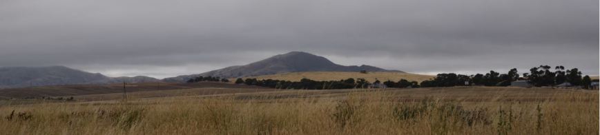
It was quite a cool morning, with light drizzle and lots of cloud cover. It did not look particularly great for the activation, and both Marija and I commented that we hoped it would clear up by the time we reached Mount Bryan.
Just outside of Burra (about 3 km) on the Barrier Highway, we made a brief stop to take a photo of a little farmhouse which is rather famous. The 1920’s cottage featured on the cover of Midnight Oil’s ‘Diesel and Dust’ chart topping album released in 1987. The cottage itself was voted number 2 in the 100 Best Views in Australia by Australian Traveller magazine.
In 2013 the locals realised the importance of saving this little house, and commenced a preservation fund to restore and repair the house. Click on the link below to listen to a very interesting article from ABC Radio about the restoration process…..
http://www.abc.net.au/local/videos/2013/04/16/3737929.htm
We continued north along the Barrier Highway and it wasn’t long before Mount Bryan came into view.
We then entered Mount Bryan township, about 18 km north of Burra. The town itself was named after the nearby peak. Mount Bryan was once a busy hub of rail transport where 44 trains per week rolled to a halt. Shunting lines to the cattle and shee yars, cream and egg shed, a cloakroom, good sheds, the Station Master’s Office and wheat stack yard all previously existed. In addition to the daily passenger train services to Adelaide, the train line provided fresh fruit and vegetables, mail and health services to the district. Passenger services departed from 1880 to 1968. Sadly that is all long gone, and there is not much in Mount Bryan, other than a few houses and the historic pub.
We did stop briefly to have a look at one of the wind turbine blades and the associated interpretive signs.
Marija and I then drove north east out of Mount Bryan along the Mount Bryan East Road, which is the commencement point of the Dare Hill circuit. We stopped to have a look at the Mount Bryan Bible Christian Chapel ruins. The chapel was built in 1871 and was the place of worship of Henry Collins (1832-1929, a pastoral pioneer of the district who established the Lucerndale sheep stud. Collins arrived here in 1859 and too up 80 acres of land on which he built a single room pine and daub cottage. He engaged in carting wood to the Burra mine. In 1879 as an experiment, he was the first to plant lucerne on his property which flourished. As a result of this valueable crop, in 1884 he was able to buy a stud ram and quality ewes, on which he based the development of his successful sheep breeding venture.
The following is an extract from The Advertiser, Saturday 19th October 1929 re his death

We continued along Mount Bryan Road East, with the weather still looking very ominous. This area is dotted by various ruins, a reminder of the very difficult and remote life that the pastoralists led during the 1800’s and early 1900’s.

Marija and I detoured from the Dare Hill route, and turned left onto Glen View Road and then on to Banbury Road and headed north west towards the summit. About 3 km up the road we reached the gate which we needed to go through to get up to Mount Bryan. This is private property, so please DO NOT enter the property unless you have the specific permission of the landowner, which Marija and I had. I had received some information from Ian VK5CZ and Hugh VK5NHG that the gates may have been locked and they gave me some clues on where to find the key. But fortunately the gates were not locked on this occasion.
We followed the dirt track right up to the summit, passing through a number of closed gates, ensuring we closed the gates and left them as we found them. I would not recommend this track in a conventional vehicle as there are some very rocky spots and a number of washaways.
There were some great views to be had through the mist of the surrounding countryside and the paddocks were alive with kangaroos.

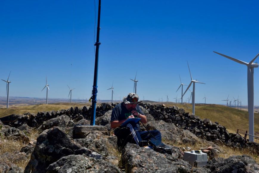
We reached the top of the summit and parked the Toyota Hi Lux and walked a short distance to the trig point. Mount Bryan is 933 metres above sea level and is the highest point on the Razorback Range. It is worth 8 points for the Summits on the Air (SOTA) program. All that is left of the trig point now are three 1.5 metre pole painted in bright blue. There is also a stone chair which I am sure would be a welcome site for those climbing up the summit along the famous Heysen Trail.
There is quite a bit of communications equipment on top of Mount Bryan, but I have found that it has never caused any interference during my previous activations of the summit.
There are some fantastic views to be had of the surrounding countryside from the top of Mount Bryan.
Mount Bryan was first sighted by explored Edward John Eyre (1815-1901), who explored the area in July 1839.
Above:- Edward John Eyre. Courtesy of wikipedia.
The area was next explored in December 1839, by Lieutenant-Colonel George Gawler (1795-1869) the second Governor of S.A. & Captain Charles Sturt (1795-1869), and their party. This included a young man called Henry Bryan, in whose honour, Gawler named the summit.

replica by John Michael Crossland,painting,circa 1853
Above:- Captain Charles Sturt (left) & Governor Gawler (right). Images courtesy of wikipedia
In 1842, the Colonial Surveyor, Lieutenant Edward Frome (1802-1890) , further explored the area and he erected a cairn on the summit. He is reported to have been the first European to have climbed the summit. Frome later visited the area, at which time he climbed the summit and made a number of sketches. He also erected a stone cairn. Sadly in 1970, when Mount Bryan summit became a Government Water Reserve, the S.A. Water Authority demolished Frome’s historic cairn, to make way for other engineering works. I am sure this would not happen nowadys!
Above:- Edward Frome and one of his sketches. Images courtesy of wikipedia
In December 1839, Governor Gawler and Captain Charles Sturt set out ‘to examine the land along the Murray river, with the hope of finding fertile country; and also to determine the capabilities of river and lake for inland navigation’. We know a lot about this expedition due to the efforts of Sturt’s biographer, Beatrix Sturt, who was also Sturt’s daughter in law. Sturt informed her directly re the expedition, and she also had access to all of his private papers.
The expedition was first discussed by Gawler and Sturt in November 1839. They proposed to cross Lake Alexandrina from Currency Creek, near the present town of Goolwa. They were to proceed up the Murray to the Great Bend, and then return overland to Adelaide. The expedition party consisted of Governor Gawler, his 15 year old daughter Julia, Captain Charles Sturt and his wife Charlotte, Eliza Arbuckle who was Charlotte Sturt’s maid servant, Henry Inman Superintendent of Police, Henry Bryan a house guest of Gawler, WIlliam Pullen the Colonial Marine Surveyor, Arthur Gell who was Gawler’s Personal Secretary, John Craig Aide to Gawler, Isaac Hearnshaw Aide to Gawler, and local aboriginal interpreters.

Above:- Map of Gov Gawler’s expedition to Mount Bryan in 1839. Courtesy of http://www.charlesturtmuseum.com
The Party set off from near present day Goolwa, and sailed in 4 little boats across Lake Alexandrina from Currency Creek, and proceeded up the Murray River to current day Morgan. After their arrival on Tuesday, the 10th December, at what was described as the ‘Great bend’ in the river at Morgan, they set up camp at the entrance of Bryan (Burra) Creek. The following day on Wednesday the 11th December, Gawler, Sturt, Inman, Craig, and Bryan, set off on horseback with a week’s provisions and 2 barrels of water to explore the country.
It was at approximately 12 noon on the 11th December, 1839, on a small hill to the north east of the campsite, that Gawler saw a mountain in the distance and immediately named it Mount Bryan after his young friend, Henry Bryan.
However by the first night, when about ’32 miles’ from the river, it was discovered that the barrels had leaked and much of the water had evaporated in the extreme heat.
A second day of extreme weather left barely a trace of water in the barrels and the situation was critical. Smoke was seen in the vicinity of Mount Bryan and the Party assumed that this indicated the presence of aboriginals, and thus water. Gawler later stated:-
“While contemplating the scene about us, smokes were observed to arise on Mount Bryan. Smokes indicate Natives, and Natives indicate the neighbourhood of water. Our casks had leaked, the bung had escaped from one of them, and the consequence was that our stock of water was just exhausted…..On the following morning, leaving Captain Sturt and Mr H Bryan in charge of our provisions and packhorses, I and Mr Inman set out in search of the Natives and water, but after toiling over the spurs and through the gullies during the morning of another hot day we could not find either. We found an extinguished Native fire and a ruined Native hut, but that was all, and we returned to the party to say that no alternative remained but to press through the night for our station on the Murray….”
It was at this time that Sturt bled one of the remaining three horses and all partook in this desperate attempt at survival.
On Friday the 13th of December, with all of their water gone and the temperatures rising, Sturt recommended that Gawler and Bryan set off on the strongest horses to seek help. They were about ’65 miles’ (110 kms) from the camp on the river. It was organised that Sturt, Inman, and Craig would follow a short time later.
On Saturday the 14th of December, Gawler and his horse could not proceed any further due to the heat and lack of water. Gawler and Bryan then swapped horses so that Bryan could ride the Governor’s horse slowly for the remaining ’12 miles’ to the camp, and Gawler would ride ahead.
By Sunday the 15th December, Gawler had reached the camp, however he had lost sight of Bryan at this time. He was followed soon after by Sturt, Inman and Craig. But there was no sign of Byran.
On Monday the 16th with the assistance of a local aboriginal, the group tracked the hoof prints of Bryan’s horse, about ‘five miles’ through the bush. They located Bryan’s blankets, coat, and stockings, and Gawler’s saddle, bridle, and telescope. On a scrap piece of paper, dated 9 p.m. Sunday 15th, Bryan had written that he ‘had been detained by exhaustion‘ but was going to the south-southeast.

Above – Henry Bryan’s letter. Courtesy of http://www.murrayriver.com.au
Beatrice Sturt wrote:-
“A second careful search at this spot disclosed the tree to which he had tethered his horse. The animal on escaping had taken a course due west to the hills with his rope trailing after him, and he eventually found his way back to Adelaide. But not search could disclose even to a native’s piercing eye any footprint or other mark in the direction indicated. Repeated efforts were made; they examined every bush, fired at intervals, constantly shouted; but to no purpose, nor was any further trace of ‘Bryan’ ever found”.
Bryan’s horse amazing eventually made its way back to Adelaide, with its hoofs grown to enormous lengths. And as for Bryan, he was never seen again, and has not been declared missing or presumed dead, nor has a death certificate been issued.
Gawler later wrote:-
“I never had so deep a regard for any young man that I had known for the same length of time, his character, looking at it with the severity of a Christian eye, was more faultless that that of any other individual of the same age”.
Marija and I were running about 30 minutes behind schedule and our advertised operating time of 2300 UTC. It was extremely windy and I was very concerned that if I set up near the trig point, the squid pole would snap. So we walked a few metres down hill from the trig point, trying to get out of the wind. We chose a spot behind some moss rocks and some small shrubs, which afforded some protection from the wind. But as you can see from the photographs below, the wind was extremely strong and the squid pole certainly had some flex in it.
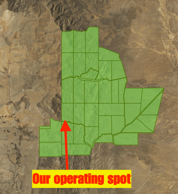
 Above: Aerial shot of the summit, showing our operating spot. Image courtesy of google maps.
For this activation Marija and I ran the Yaesu FT-857d and the 80/40/20 m linked dipole on the top of the 7 m heavy duty telescopic squid pole. We decided to run the transceiver at 10 watts, rather than going in and out of the menu and increasing the power for me. As a Foundation licence holder, Marija is only permittted to run 10 watts PEP.
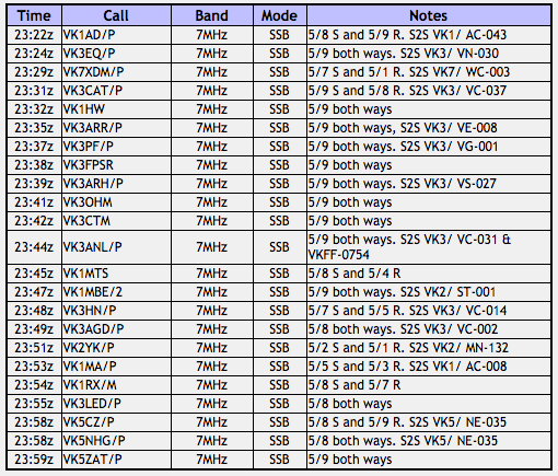
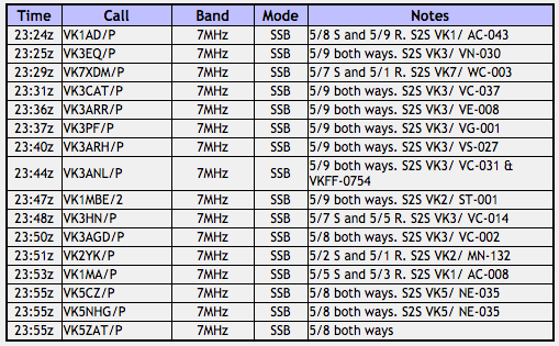
Prior to lobbing on a frequency and calling CQ we scouted around the 40m band and worked a few of the SOTA activators. The first in the log was Andrew VK1AD, running QRP 5 watts from SOTA peak Mount Stromlo VK1/ AC-043. Andrew was an excellent 5/8 to us and he reciprocated with a 5/9 signal report for Marija and I. We then worked Rik VK3EQ on Mount Strickland VK3/ VN-030, followed by Mitch VK7XDM/p on Mount Field West VK7/ WC-003, and then Tony VK3CAT/p, VK3/ VC-037. As we were signing with Tony Haucke VK1HW called me and we arranged to QSY down the band.
Marija and I had soon very quickly qualified the summit, exchanging the microphone for contacts. After getting her 4 contacts to qualify the summit, Marija predominantly just worked the SOTA activators, racking up a significant number of Summit to Summit points.
The 40m band was in excellent condition and there was virtually no atmospheric noise on the band, and certainly no man made noise from Mount Bryan. Contacts were made into VK1, VK2, VK3, VK4, VK5 and VK7. The pile ups at times were quite significant, so I apologise to anyone who was calling and who was not logged by Marija and I.
I made a total of 70 contacts on 40m before heading over to the 20m band where I worked 6 stations, including 4 Summit to Summit contacts. I was pleased to be able to get John VK6NU in the log, who was on the top of Mount Randall VK6/ SW-039 (5/3 both ways).
S2S contacts for me before the UTC rollover:-
- Andrew VK1AD/p, Mount Stromlo VK1/ AC-043 (1 point)
- Rik VK3EQ/p, Mount Strickland VK3/ VN-030 (6 points)
- Mitch VK7XDM/p, Mount Field West VK7/ WC-003 (10 points)
- Tony VK3CAT/p, VK3/ VC-037 (1 point)
- Andrew VK3ARR/p, Mount Buller VK3/ VE-008 (8 points)
- Peter VK3PF/p, Mount Cope VK3/ VG-001 (10 points)
- Allen VK3ARH/p, Ben More VK3/ VS-027 (2 points)
- Nick VK3ANL/p, Arthurs Seat VK3/ VC-031 (1 point)
- Andrew VK1MBE/2, Mount Cowangerong VK2/ ST-001 (8 points)
- Paul VK3HN/p, Mount Disappointment VK3/ VC-014 (4 points)
- Adam VK3AGD/p, Mount Donna Buang VK3/ VC-002 (8 points)
- Adam VK2YK/p, Berrico VK2/ MN-132 (6 points)
- Matt VK1MA/p, Mount Ginini VK1/ AC-008 (8 points)
- Ian VK5CZ/p, Black Rock VK5/ NE-035 (8 points)
- Hugh VK5NHG/p, Black Rock VK5/ NE-035
A total of 81 points Summit to Summit points.
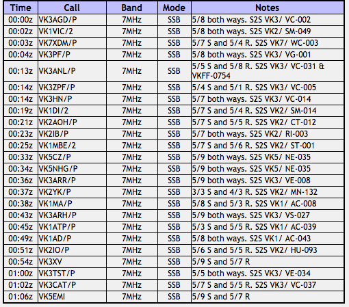
S2S contacts for me after the UTC rollover:-
- Adam VK3AGD/p, Mount Donna Buang VK3/ VC-002 (8 points)
- Tony VK1VIC/2, Mount Tumanang VK2/ SM-049 (8 points)
- Mitch VK7XDM/p, Mount Field West VK7/ WC-003 (10 points)
- Peter VK3PF/p, Mount Cope VK3/ VG-001 (10 points)
- Nick VK3ANL/p, Arthurs Seat VK3/ VC-031 (1 point)
- Peter VK3ZPF/p, Mount Vinegar VK3/ VC-005 (6 points)
- Paul VK3HN/p, Mount Disappointment VK3/ VC-014 (4 points)
- Ian VK1DI/2, The Cascades VK2/ SM-014 (10 points)
- Nick VK2AOH/p, VK2/ CT-012 (6 points)
- Bernard VK2IB/p, Wagra Mountain VK2/ RI-003 (6 points)
- Andrew VK1MBE/2, Mount Cowangerong VK2/ ST-001 (8 points)
- Ian VK5CZ/p, Black Rock VK5/ NE-035 (8 points)
- Hugh VK5NHG/p, VK5/ NE-035
- Andrew VK3ARR/p, Mount Buller VK3/ VE-008 (8 points)
- Adam VK2YK/p, Berrico VK2/ MN-132 (6 points)
- Matt VK1MA/p, Mount Ginini VK1/ AC-008 (8 points)
- Allen VK3ARH/p, Ben More VK3/ VS-027 (2 points)
- VK1ATP/p, Yellow Rabbit Hill VK1/ AC-039 (1 point)
- Andrew VK1AD/p, Mount Stromlo VK1/ AC-043 (1 point)
- Gerard VK2IO/p, Mount Elliott VK2/ HU-093 (1 point)
- Marcus VK3TST/p, Mount Mcleod VK3/ VE-034 (10 points)
- Tony VK3CAT/p, VK3/ VC-037 (1 point)
- Adam VK2YK/p, Berrico VK2/ MN-132 (20m)
- Matt VK1MA/p, Mount Ginini VK1/ AC-008 (20m)
- John VK6NU/p, Mount Randall VK6/ SW-039 (2 points)
- Tony VK1VIC/2, Mount Tumanang VK2/ SM-049 (20m)
A total of 125 Summit to Summit points
Marija made a total of 15 Summit to Summit contacts before the UTC rollover (81 points) and a total of 22 S2S contacts after the UTC rollover (114 points).
After 2 hours on the summit it was time for us to pack up. It was now midday local time, and we had quite a drive ahead of us on the Dare Hill drive, and also two planned park activations. I had a total of 76 QSOs in the log including 41 S2S contacts. Marija had a total of 39 QSOs in the log including 37 S2S contacts.
As a result of this activation, Marija has now qualified for the following SOTA certificates:
- SOTA Chaser 100 points
- SOTA Chaser 250 points
- SOTA Summit to Summit 250 points
I worked the following stations:-

Marija worked the following stations:-
After getting down off the summit we took a short detour before leaving the property to have a look at an old ruin. Hugh VK5NHG had told us it was worth a look as there was an old mural inside the cottage. We soon found the old stone cottage amongst the gum trees. Above the fire place there are the words which read “God Save the King’. I have spoken with Tony Brooks, the owner of the property and he has advised he does not know a lot about the history of this little cottage. He did advise it was a shepherds cottage and that it was referred to as ‘Angels Rest’.
Marija and I then left the property and drove back down along Banbury Road and on to Mount Bryan Road East. The drizzle and cloud had cleared and there were now some very nice views to be had of the summit.
We continued on to our next activation of the day, the Caroona Creek Conservation Park.
References.
<http://www.charlessturtmuseum.com.au/>, viewed 4th January 2017
Discover Murray, <http://www.murrayriver.com.au/morgan/mt-bryan-expedition/>, viewed 4th January 2017.
Wikipedia, <http://en.wikipedia.org/wiki/Burra,_South_Australia>, viewed 4th January 2017