
Yesterday (Monday 1st October 2018) I activated the Onkaparinga River National Park 5NP-019 & VKFF-0402. I have activated and qualified this park previously, so this was just going to be a fun late afternoon of activating from the park.
The Onkaparinga River National Park is about 35 km (by road) south of Adelaide, near the famous McLaren Vale wine growing region.
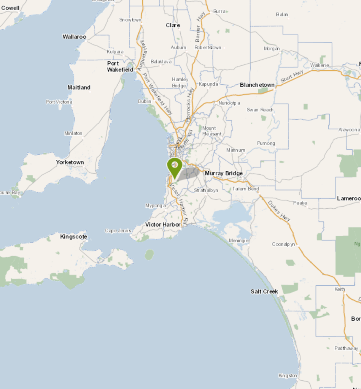
Above:- Map showing the location of the Onkaparinga River National Park. Map courtesy of Location SA Map Viewer.
The Onkaparinga River National Park is about 15.42 km2 in size, and was established on the 5th August 1993. The name ‘Onkaparinga’ comes from ‘Ngangkiparinga’, an indigenous word meaning ‘The Women’s River’. The park extends over the floodplain of the Onkaparinga River, east of Main South Road. The Onkaparinga River, known as Ngangkiparri in the Kaurna aboriginal language, flows from the slopes of the Mount Lofty Range between Mount Torrens and Charleston, and flows generally southwesterly, south of Adelaide, to reach its mouth at Port Noarlunga. The park features rugged ridge tops and the narrow river valley of the spectacular Onkaparinga Gorge.


Below are two short videos which really give you a good impression of the spectacular nature of the Onkaparinga River National Park.
Most of the land now dedicated to the national park was purchased in the period 1973 to 1977 by the former State Planning Authority. The purpose of the land acquisition was ‘to provide open space for recreational purposes’, ‘to preserve the natural character of the landscape, including the native flora and fauna’ and thirdly, ‘to function as a buffer between areas of urban and rural land.’
In 1982, the majority of the land was transferred to the then Department for Environment and Heritage which established the Onkaparinga River Recreation Park in 1985. In 1993, all of the land east of Main South Road (known as the gorge section’) was reclassified as the Onkaparinga River National Park.
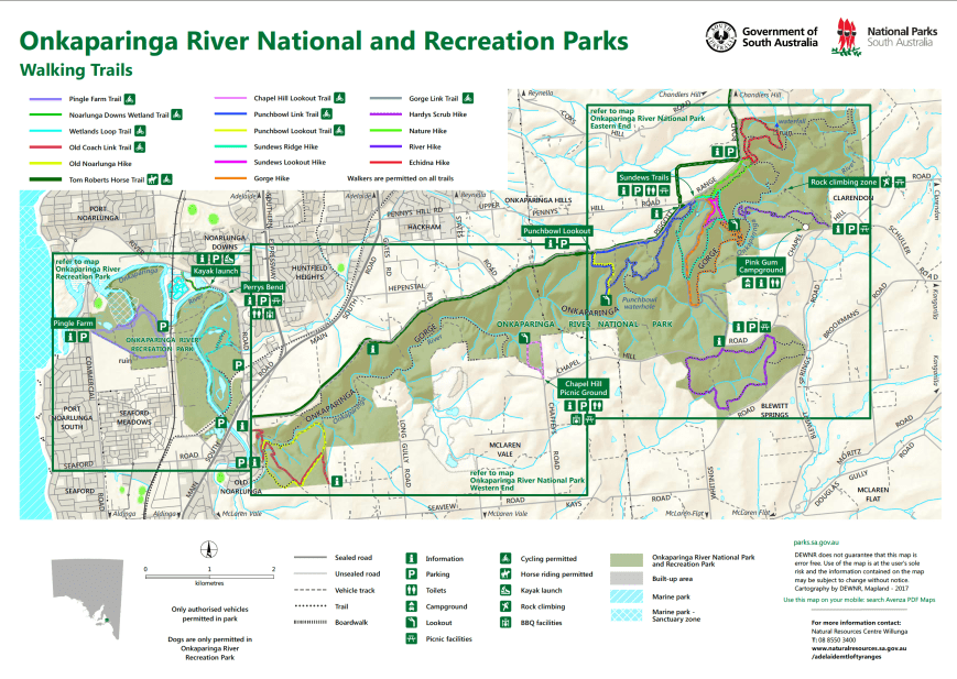
Above:- Map of the Onkaparinga River National Park. Image courtesy of DEWNR.
Due to European settlement, much of the vegetation of the park has been greatly impacted. The most intact part of the park is the Hardy’s Scrub section of the park. Sadly, 160 years of livestock grazing, timber harvesting and cropping has cleared most of the reserve of native understorey species. Remnant eucalypts are the most noticeable native species in the reserve.
Native animals found in the park include the Western Grey kangaroo , Common brushtail possum, Common ringtail possum, echidna, Lesser long eared bat, and the Southern forest bat.
Birds SA have recovered about 84 native species of bird in the park including Superb Fairywren, Yellow-faced Honeyeater, Brown Thornbill, Striated Thpornbill, Australian Magpie, Black-winged Currawong, Brush Bronzewing, Peregrine Falcon, and White-throated Gerygone.
Approximately 20 fish species are recorded for the estuary and river. The major fish species include jumping mullet, black bream and yellow-eye mullet. Amphibians found in the park include common froglet, banjo frog, spotted marsh frog and brown tree frog. At least 20 reptile species have been recorded in the park including cunningham’s skink, eastern bearded dragon and barking gecko.
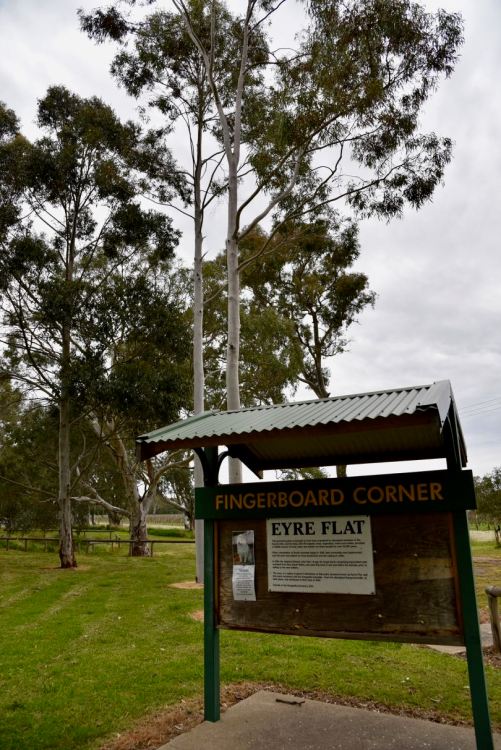
To get to the park I travelled through Meadows and on to the little town of Kangarilla. The town was originally called Scaldwell, then Eyre Flat, and then Kangarilla in 1862. Kangarilla is a Kaurna aboriginal word meaning ‘place of two springs’.


I then stopped briefly to have a look at the information board at Fingerboard Corner at Eyre Flat. It details the history of the area and states that in a radius of about 5 km from this point, the area became known as Eyres Flat, until the township of Kangarilla was established.
I took Bakers Gully Road and then Chapel Hill Road, travelling through beautiful rolling green countryside and vineyards.


My preferred operating spot near the Pink Gum campground was swarming with people, so I continued along Chapel Hill Road until I reached gate 20. I parked the vehicle in the carpark on the opposite side of the road, and set up about 20 metres down a walking track.
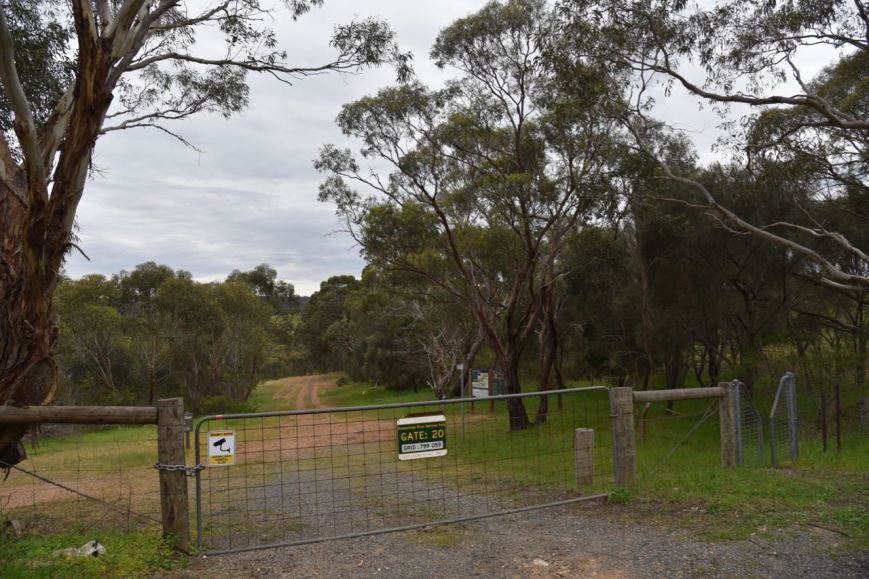
There was plenty of room here to string out the 20/40/80m linked dipole, without encroaching on other park users. I ran the Yaesu FT-857d at 40 watts for the activation.
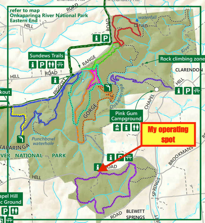
Above:- Map showing my operating spot near the Sundews Trail. Image courtesy of DEWNR.
Once I had set up I turned on the transceiver and tuned to 7.144. Along the way I found Gerard VK2IO/p on 7.143, activating the Garigal National Park VKFF-0191. It was a nice way to start the activation with a Park to Park. It was 4.00 p.m. local time and I thought I may have left my run a little too late to log any other park activators.
After working Gerard I moved down to 7.130 and started calling CQ. Peter VK2UXO was first in the log, with a very big signal from near Griffith in New South Wales. Rob VK4SYD then gave me a shout, followed by Steve VK4VCO, and then Mark VK4SMA. All the signals from Queensland were nice and strong.
Contact number seven was another Park to Park QSO, this time with Peter VK3ZPF/p who was activating the Nyora Nature Conservation Reserve VKFF-2169. I logged a total of 15 stations on 40m until things slowed down. Callers were from VK2, VK3, VK4, VK5, and New Zealand. Regular park hunter, Andrei ZL1TM gave me a shout from Auckland, with a good 5/5 signal.
I was hoping to get some DX in the log, so I then lowered the squid pole and removed the links in the antenna for the 20m band. I called CQ on 14.310 for a good 10 minutes, but had absolutely no takers. I was competing with the Over the Horizon Radar, and a tune across the 20m band revealed only a few low down European signals.


I then called CQ on 3.610 after self spotting on parksnpeaks. First in the log on 80m was Andy VK5LA in the Riverland region of South Australia. This was followed by Adrian VK5FANA on the Yorke Peninsula, Barry VK5BW in the Adelaide Hills, and then Gerard VK2IO/p in the Garigal National Park VKFF-0191. I ended up logging a total of 16 stations on 80m which was really pleasing. Callers were from as far afield as Brisbane.
I then moved back to 7.130 on 40m and called CQ again. This was answered by Dennis VK2HHA, followed by Matt VK4PZZ and then Kimberly VK2KMI. I logged a further 6 stations on 40m from VK2, VK4, VK5, and VK6. I put out a few more unanswered CQ calls, before having a tune across the band. And I am very pleased I did. I heard Darren 5W0DJ calling CQ on 7.152 with a good 5/8 signal. And he wasn’t busy. I got through on my first call, with a 5/5 signal report received back from Samoa. This was a new country for me whilst operating portable. I am trying to get DXCC whilst operating portable, and I am currently sitting on 82 different DXCC entities worked (whilst in a park or on a summit). Just 18 more to go to pick up ‘portable’ DXCC.
To complete the activation I headed back to 80m where I was hoping to log John VK5BJE. And sure enough I did. John was first in the log after returning to 80. I logged a further 5 stations from VK2, VK3 and VK5.


After 2 very enjoyable hours in the park I had a total of 47 contacts in the log, including 4 Park to Park contacts. Whilst in the park I had a number of conversations with passers by, explaining to them the hobby of amateur radio.
I worked the following stations on 40m SSB:-
- VK2IO/p (Garigal National Park VKFF-0191)
- VK2UXO
- VK4SYD
- VK4VCO
- VK4SMA
- VK3SQ
- VK3ZPF/p (Nyora Nature Conservation Reserve VKFF-2169)
- VK5FMWW
- VK4NH
- VK4DXA
- ZL4TY/VK4
- VK2XSE/p (Cocopara National Park VKFF-0104)
- ZL1TM
- VK2WOW
- VK5YX
- VK2HHA
- VK4PZZ
- VK2KMI
- VK5BJE
- VK2SR
- VK2NZ
- VK4FDJL
- VK6YTS
- VK4HNS
- 5W0DJ
I worked the following stations on 80m SSB:-
- VK5LA
- VK5FANA
- VK5BW
- VK2IO/p (Garigal National Park VKFF-0191)
- VK3PF
- VK5ZK
- VK5FMWW
- VK5FMAZ
- VK3FJHR
- VK2NP
- VK4CZ
- VK4HNS
- VK3SQ
- VK3ANL
- VK3KWB
- VK2MWK
- VK5BJE
- VK2HHA
- VK5FRSM
- VK2KMG
- VK3ZSG
- VK3FXBR
References.
Birds SA, 2018, <https://birdssa.asn.au/location/onkaparinga-river-recreation-park-2/>, viewed 2nd October 2018
City of Onkaparinga, 2018, <http://onkaparingacity.com/onka/discover/history_heritage/history_of_onkaparinga.jsp>, viewed 2nd October 2018
Wikipedia, 2018, <https://en.wikipedia.org/wiki/Onkaparinga_River_National_Park>, viewed 2nd October 2018
Wikipedia, 2018, <https://en.wikipedia.org/wiki/Onkaparinga_River>, viewed 2nd October 2018
Wikipedia, 2018, <https://en.wikipedia.org/wiki/Kangarilla,_South_Australia>, viewed 2nd October 2018

Hi Paul
I must go exploring the park. We have done quite a few walks down to the river: steep paths and lots of rock-hopping and enjoyed that. I have only operated from the park once and I wasn’t happy with my location off Penny’s Hill Road. I saw on your earlier post about the park that you went to the picnic ground and had it to yourself. But I doubted whether that would be the case over a long weekend as you discovered. I am pleased to be in your log for two bands. I will get to the park soon and try and finish my WWFF activation. By the way I worked Darren, 5W0DJ, and also received 5 and 5. Thanks for the tip.
73
John D
VK5BJE/VK5PF
Hi John,
Being a long weekend, there was plenty of activity in the park. I must do the same one day as you, and go for a walk along one of the tracks which takes you down towards the river.
Thanks for the contacts on 2 bands.
73,
Paul VK5PAS.