Here is a short 9 minute video of my activation with Marija VK5FMAZ at the Marino Rocks lighthouse and the Marino Conservation Park for the 2017 International Lighthouse & Lightship Weekend (ILLW).

Here is a short 9 minute video of my activation with Marija VK5FMAZ at the Marino Rocks lighthouse and the Marino Conservation Park for the 2017 International Lighthouse & Lightship Weekend (ILLW).
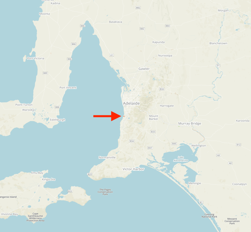
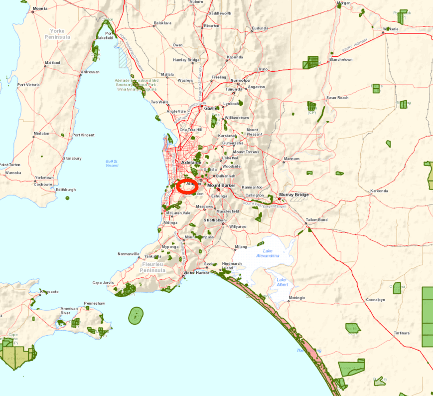
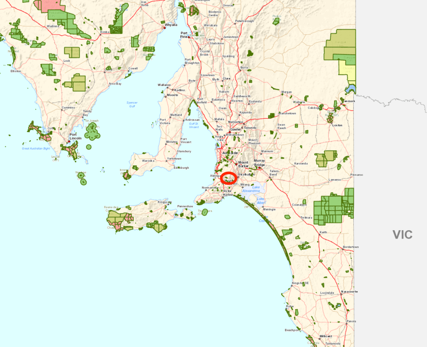
I have just finished 7 days straight at work and I was very keen to head out to activate a park today (Monday 28th August 2017). I am running out of parks within about 300 km from home, but one park I have not activated is the Lawari Conservation Park 5CP-278 & VKFF-1767. The park is located about 100 km south of Adelaide and about 56 km south of my home in the Adelaide Hills.
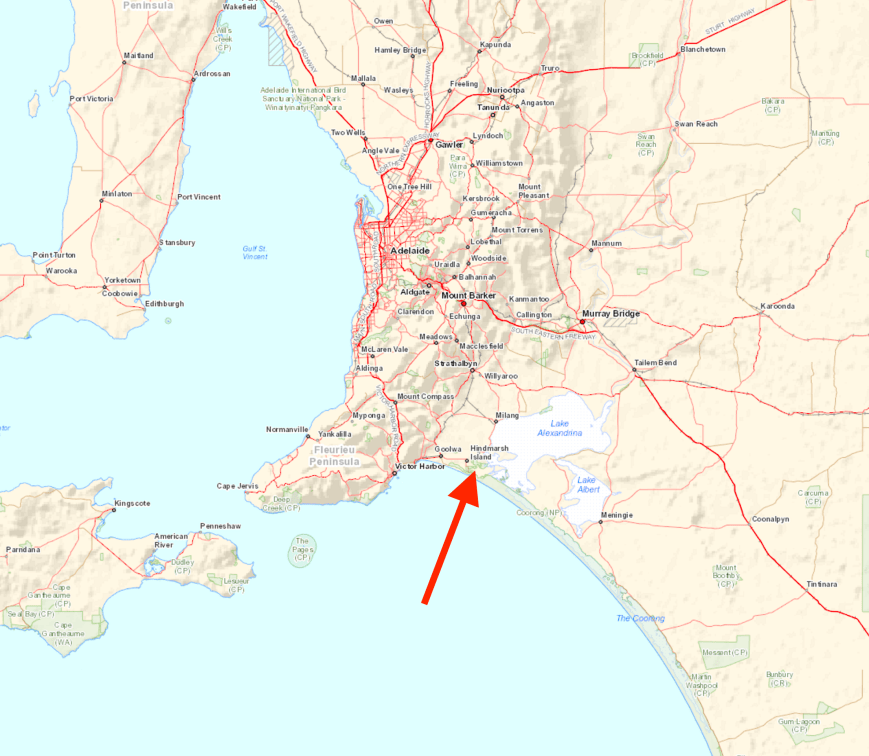
Above:- Map showing the location of the Lawari Conservation Park south of Adelaide. Map courtesy of Location SA Map Viewer.
Lawari Conservation Park is located on Hindmarsh Island and is accessed via the township of Goolwa, which is a historic river port on the Murray River near the Murray Mouth. In the local Ngarrindjeri aboriginal language, Goolwa means ‘elbow’. The area was known as ‘The Elbow” by many of the early settlers. Before 1837 the area was briefly considered for the site of the capital of the colony of South Australia. Goolwa was Australia’s first inland port (1853) built to connect Goolwa to Port Elliot and later extended to Victor Harbor, allowing goods to move from river boats to sea boats, so that neither had to negotiate the Murray Mouth.
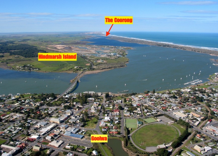
Above:- Aerial view showing Goolwa, the Hindmarsh Island bridge and the island, and also the Coorong. Image courtesy of Alexandinra Council.
Hindmarsh Island, known Kumerangk in the local aboriginal language, is a popular tourist destination. Tourism to the island has increased in popularity since the opening of the Hindmarsh Island bridge in 2001.

The island is 45.5 km2 in size, with a length of 14.7 km and a width of 6.5 km. The island has a coastline of 43.7 km. Its highest elevation is just 25 metres. The island’s population is around 1,200. It has a marina development and tavern.


Construction on the Hindmarsh Island bridge, linking the island to Goolwa, commenced in October 1999, with the bridge being completed in March 2001. The bridge is 319 metres in length, with a height of 19 metres.
The bridge became a focus of national controversy when a group of local Indigenous people, the Ngarrindjeri, and some landowners objected to its construction. It was alleged that the Ngarrindjeri objectors fabricated the cultural significance of the island (the Secret Women’s Business) in order to help fight the development. A later Royal Commission decided that the Secret Women’s Business was in fact made up. Construction was blocked by the Keating Labor Government, but given the go-ahead by the Howard Liberal Government in 1996.
Five years after the Royal Commission findings, the Ngarrindjeri who had stated the bridge desecrated sites sacred to women were vindicated, with a Federal Court Judge finding that restricted women’s knowledge was not fabricated or that it was not part of genuine Aboriginal tradition.
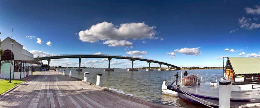
Above:- the Hindmarsh Island bridge. Courtesy of Alexandrina Council.
The first European to set foot on Hindmarsh Island was Captain Charles Sturt. He used the island as a viewing point and from there he sighted the Murray Mouth. Captain Collet Barker surveyed the Murray Mouth but was killed by aboriginals after swimming across the Mouth. The island was named by Captain John William Dundas Blenkinsop after South Australia’s first Governor, Sir John Hindmarsh.


Above:- Captain Charles Sturt (left) and Sir John Hindmarsh (right). Images courtesy of wikipedia.
There is a monument on the island which commemorates explorers Captain Charles Sturt and Captain Collet Barker near the site where Sturt first saw the waters of Encounter Bay.


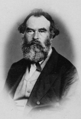
Dr. John Rankine (1801-1864) was granted an occupational licence to become the island’s first grazier. He is recognised as founding the township of Strathalbyn, just down the road from my home.

Dr. John Rankine. Image courtesy of wikipedia
The Lawari Conservation Park is a relatively new park, having been gazetted on 21st March 2017. The park is 1.058 km2 (1,058-hectare) in size and is located at the eastern end of Hindmarsh Island, within an area of wetlands that support a large number of threatened fish and water bird species. The park supports three native fauna species of national conservation significance, and a further 30 fauna and one flora species at the state level, including the Far Eastern Curlew and Cape Barren Goose. It is situated within an area of internationally important wetlands formally recognised as the Coorong and Lakes Alexandrina and Albert Ramsar Reserve.
Lawari Conservation Park comprises two former grazing properties, purchased with assistance from the Commonwealth’s National Reserve System Program for inclusion into the protected area system. This includes the former Wyndgate property.
The park includes approximately 400 hectares of fenced paddocks where cropping and cattle grazing continue under a lease agreement. These farmed paddocks are managed in a way that provides a high quality summer feeding habitat for Cape Barren geese. Although I did not sight either of these 2 birds, the park was alive with various other native birds. See my photos below.
Despite this being a large park, there really are limited operating opportunities. To start off with I travelled along Denver Road towards the old Wyndgate homestead. I reached a gate, which was open, and ventured a few hundred metres down the road, but found some cars parked at the homestead, so I decided to turn around as I was not sure if I was allowed to be where I was.
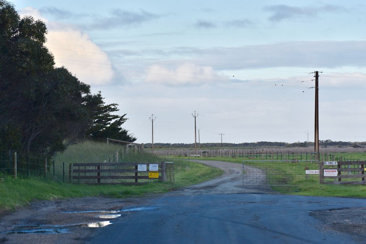
Above:- the gate at Denver Road
I then travelled back along Denver Road and then onto Randell Road. I soon had the park to my right. However, there was an electric fence and no tree cover.


I travelled to the very end of Denver Road, but could not find any suitable places to access the park. There were some nice views from here across the water to the little town of Clayton.
There was even a trig point here, but no SOTA summit!

I then travelled to the end of Mills Road, but again did not find any suitable access points into the park. I then tried Goolwa Channel Drive, but with the nearby shacks and holidays homes I decided against this spot due to the possible noise.


I decided to try my luck along Mundoo Channel Drive. Along the way I detoured to the Murray Mouth lookout.


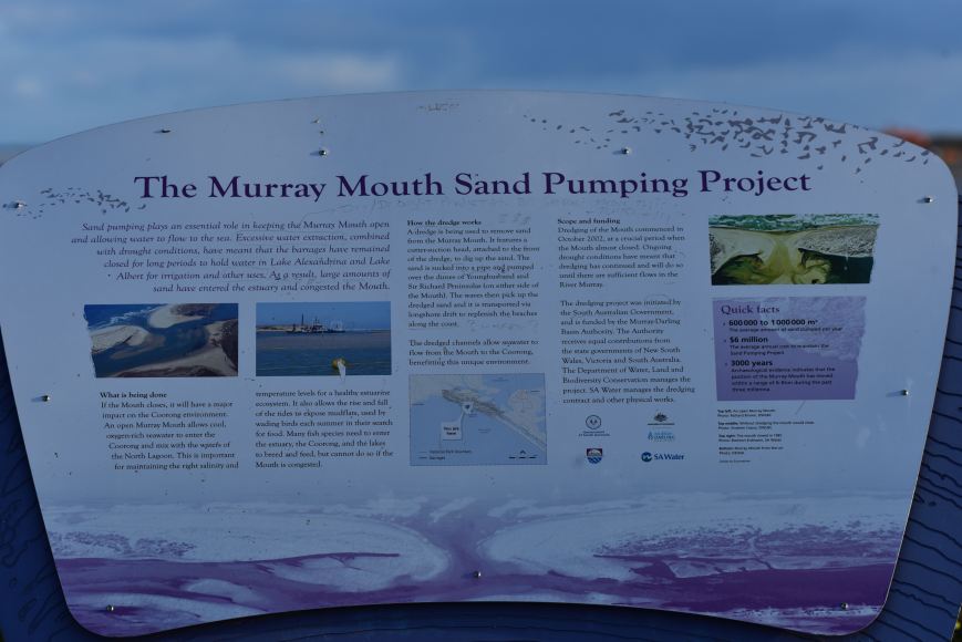
The Murray Mouth is influenced by the flow of River Murray water through the barrages and tidal movement from the Southern Ocean. When River Murray flows to South Australia are low, barrage releases are low and sand deposits occur inside the mouth causing restrictions and increasing the risk of closure. It is important that the mouth remains open to maintain connectivity between the river, the Coorong and the Southern Ocean, to discharge salt and other nutrients out to sea, and to maintain healthy ecosystems in the Coorong.
This is certainly well worth a look if you are on the island. There are also some great views of the Coorong, a lagoon ecosystem which runs parallel with the coastal dunes for about 140 km. Its name is thought to be a corruption of the local Aboriginal people’s word kurangh, meaning “long neck”; a reference to the shape of the lagoon system. The name is also thought to be from the Aboriginal word Coorang, “sand dune”, a reference to the sand dunes that form the Younghusband Peninsula.


A huge amount of planting of native plants is being undertaken in the park. During my visit there were a number of planting teams hard at work in the park.


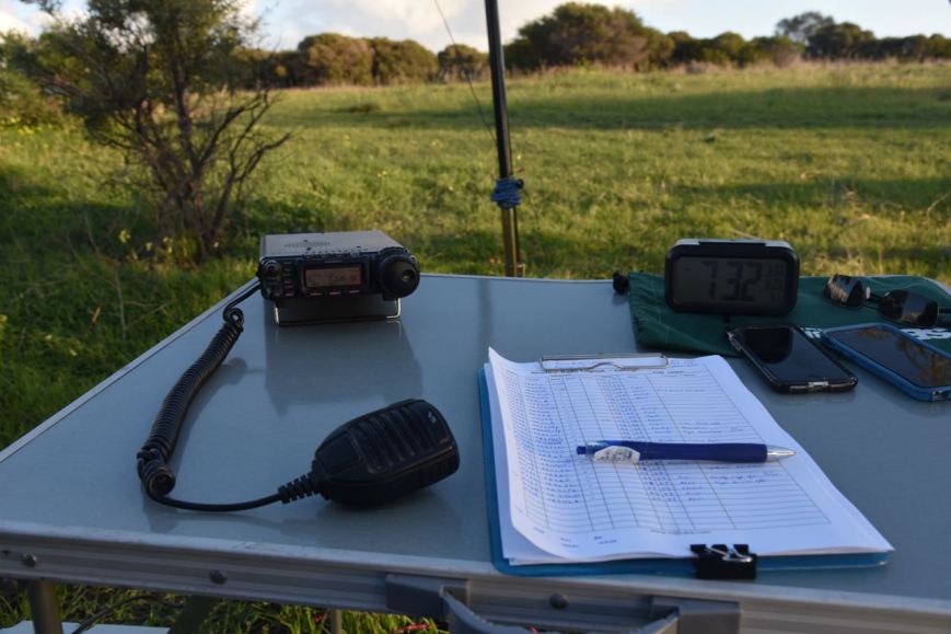
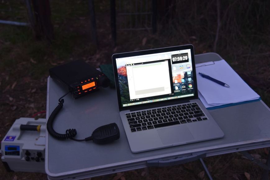
I set up off Mundoo Channel Drive. There was a newly created car parking area opposite the boat launching area. I climbed over the fence and found some shade and set up my deck chair and the fold up table. I ran the Yaesu FT-857d and the 20/40/80m linked dipole for this activation, with the power output set at 40 watts.
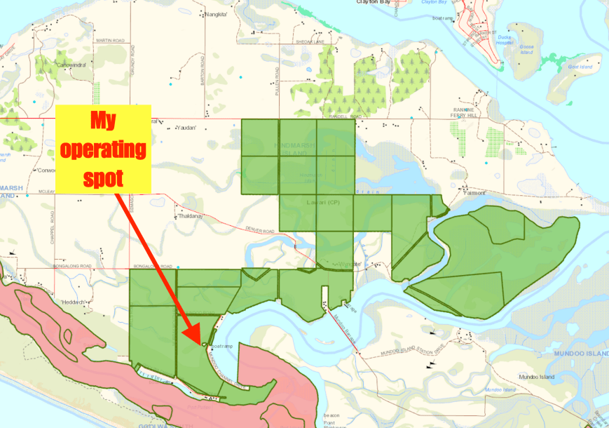
Above:- Map showing the park boundaries (in green) and my operating spot. Map courtesy of Location SA Map Viewer.
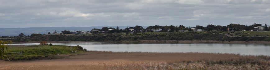
My operating spot was opposite Mundoo Channel and in close proximity to the Coorong National Park and the Mouth of the Murray, as the photo below shows.
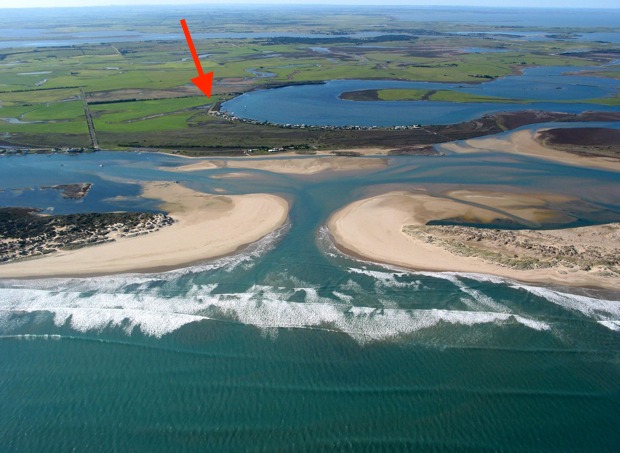
Above:- The Mouth of the Murray. My operating spot on Hindmarsh Island is indicated with the red arrow.
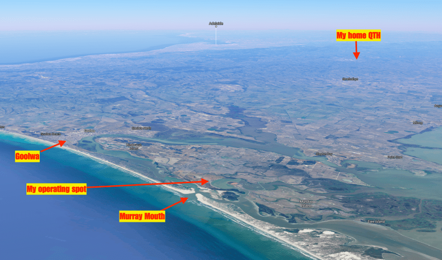
Above:- Aerial view of Hindmarsh Island, showing my operating spot, my home QTH, the Murray Mouth, and Adelaide in the background. Image courtesy of Google Maps.
I headed to my nominated operating frequency of 7.144 and started calling CQ. First in the log was Geoff VK3SQ who was become a regular park hunter. Geoff had a very nice 5/9 signal from Beechworth in north eastern Victoria. This was followed by Malcom VK1AAH in Canberra, who was also 5/9, followed by Rod VK7FRJG in Tasmania (also 5/9), and then Stuart VK3STU in Melbourne (again 5/9). Band conditions on 40m seemed very good.
As it was a Monday, calls from the park hunters were not as frenetic as a weekend. It took me about 20 minutes to reach contact number 10, qualifying the park for me for the VKFF program. Contact number 10 being with Mike VK3KMH who was 5/9 +. Callers were steady but it appeared as though I may not get the 44 QSOs required to qualify the park for the global WWFF program. I had to resort to John VK4TJ giving me his other calls from Canada and the USA, to make up the numbers.


It wasn’t until about one hour into the activation that the callers started to really pick up. I run a paper log out in the field, and each page contains 34 QSOs. I always enjoy reaching the 34 QSO mark, as this means a new page, and just 10 QSOs to go for the park to be qualified.
I ended up logging a total of 53 QSOs on 40m from VK1, VK2, VK3, VK4, VK5, and VK7, with the vast majority of signals being very good. Even the lower down stations were very readable, as there was NO noise in the park. The band was dead silent when I released the PTT button. Close in propagation was not working on 40m, with only Les VK5KLV from Port Augusta and Greg VK5GJ logged.
I headed off to 80m where I called CQ, and this was answered by George VK3MVP who had followed me down from 40m. Next up was Greg VK5GJ running QRP 4 watts with a good 5/8 signal. I logged a further 8 stations on 80m from VK2, VK3, and VK5. Again, despite it being daylight, my signal was being quite well heard in Victoria and New South Wales. I would encourage all park activators to give 80m a go during their activation.
I then headed over to 14.310 on the 20m band and logged just 3 stations. The first being John VK4TJ, followed by Jonathan VK7JON, and finally Phil VK6ADF.
To complete the activation I head back to 40m for a quick QSO with my wife Marija VK5FMAZ, who had arrived home from work.


After 2 & 1/2 hours in the park I had a total of 67 stations in the log, on 20, 40, & 80m SSB, and another unique park in the bag for me as an activator.
I worked the following stations on 40m SSB:-
I worked the following stations on 80m SSB:-
I worked the following stations on 20m SSB:-
References.
Department of Enviroment, Water and Natural Resources, 2017, <https://www.environment.sa.gov.au/Home/Full_newsevents_listing/News_Events_Listing/170419-new-park-lawari>, viewed 28th August 2017
Natural Resources SA Murray Darling Basin, 2017, <http://www.naturalresources.sa.gov.au/samurraydarlingbasin/projects/all-projects-map/wyndgate-property-planning>, viewed 28th August 2017
Wikipedia, 2016, <https://en.wikipedia.org/wiki/Goolwa,_South_Australia>, viewed 28th August 2017
Wikipedia, 2017, <https://en.wikipedia.org/wiki/Hindmarsh_Island>, viewed 28th August 2017
Wikipedia, 2017, <https://en.wikipedia.org/wiki/Lawari_Conservation_Park>, viewed 28th August 2017
Wikipedia, 2017, <https://en.wikipedia.org/wiki/Coorong_National_Park>, viewed 28th August 2017
Yesterday (Saturday 19th August 2017) my wife Marija VK5FMAZ and I headed down to the southern suburbs of Adelaide and activated the Marino Rocks lighthouse AU-0018 and the Marino Conservation Park 5CP-126 & VKFF-1056 for the 2017 International Lighthouse and Lightship Weekend (ILLW).
The park is located about 44 km from our home in the Adelaide Hills, and about 19 km south of the city of Adelaide.
This was to be a unique park for both Marija and I as activators for both the World Wide Flora Fauna (WWFF) program, and the VK5 National & Conservation Parks Award.
Above:- Map showing the location of the Marino Conservation Park. Image courtesy of Protected Planet.
The International Lighthouse and Lightship Weekend is held annually every August. The ILLW is not a contest. It is a fun weekend to raise the profile of lighthouses, lightvessels and other navigational aids, and preserve our maritime heritage.
![]()
The Marino Rocks lighthouse is a white coloured concrete structure, 14.9 metres (49 feet) high. The lighthouse is 128 metres (420 feet) above sea level. It was constructed in 1962 so in relative terms is a young lighthouse. It shows 2 flashes every 15 seconds with an intensity of 1,000,000 candelas having a range of 42 km.


The Marino Rocks lighthouse supersedes the Wonga Shoal beacon erected on a sandy shoal off Semaphore, which was knocked down by the sailing ship ‘Dimsdale’ in 1912. Consturction of the Wonga Shoal lighthouse was completed by July 1901. It was an iron structure on screw piles with accommodation for two keepers. The revolving light, weighing 11 tons floating on a bath of mercury weighing 5 tons, was 74 feet above the highwater and was visible for 19 miles.
On the evening of 16th November 1912 the British ship Dimsdale sailed up Gulf St Vincent, in ballast, seeking cargo. The Dimsdale’s captain, Captain John Jones had laid a course for the Wonga light and as he drew near, he ordered the course altered to keep the long on his port bow. However the Dimsdale was slow to respond and despite desperate efforst to avert the accident, the ship struck the lighthouse which crashed into the sea. Both lighthouse keepers, Henry Franson and Charles McGowan drowned as a result.


A court of inquiry found Captain Jones guilty of negligence and as a result his master’s certificate was suspended for 12 months. He was acquitted of the criminal offence of manslaughter.
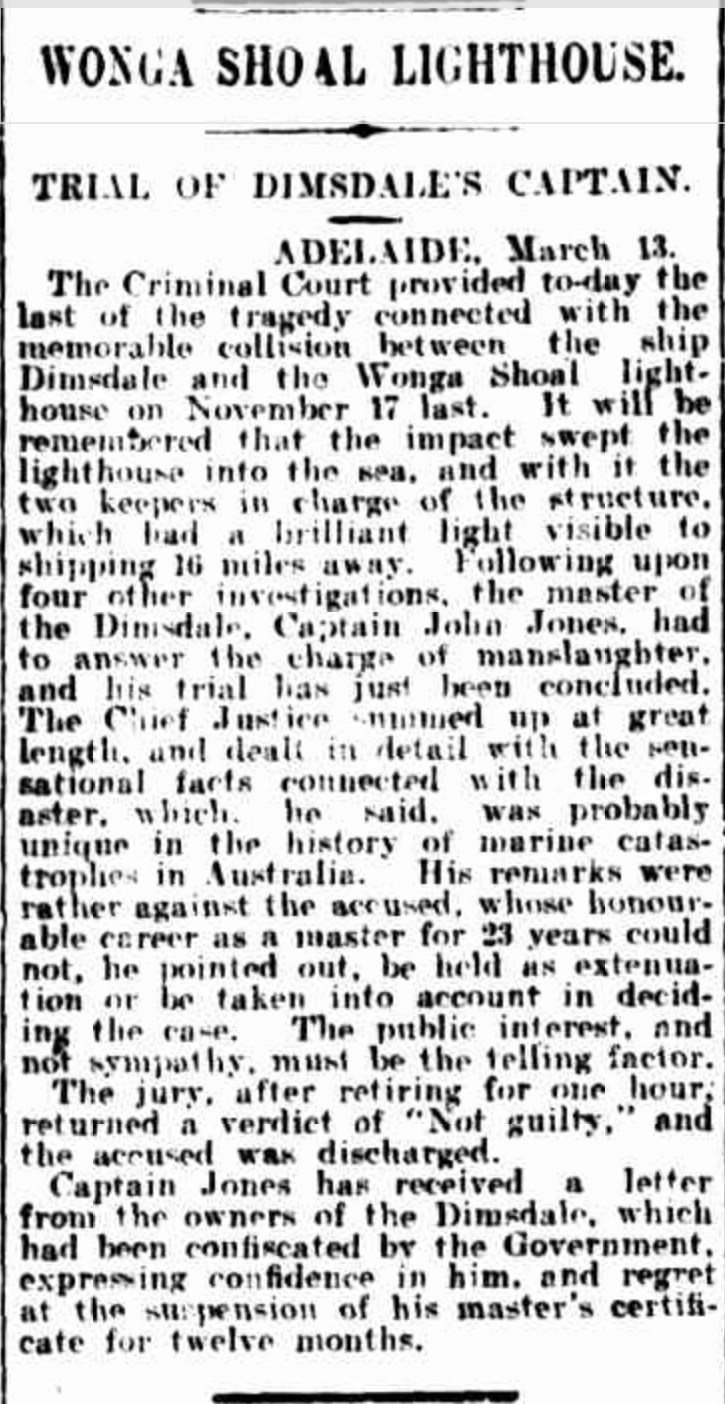
Above:- A 1913 news article on the outcome of the court case. Courtesy of Trove.
Following the tragedy, the destroyed lighthouse was replaced temporarily by a lightship, and later by a new steel structure. When the Marino Rocks lighthouse was completed in the early 1960’s the Wonga Shoal Light was finally extinguished.
The Marino Conservation Park which is 30 ha (74 acres), was established on the 2nd November 1989. It is located in the southern Adelaide suburb of Marino. In 1875 a proposal was put forward to build an outer harbour at Marino. The proposal was furthered in 1880 in a report by Captain H.S. Stanley, R.N. and in 1901 a Marino Outer Harbour League was formed. However, in 1908 the construction of the Outer Harbour near Port Adelaide finally laid these plans to rest.
The exact origin of the name of Marino is unclear. It is generally believed that Marino is named after two landmarks known to Charles Kingston, who bought property in the area in 1849. Charles Kingston, an Irishman who came out to South Australia on board the Cygnet. He would often boast that he was “the first Irishman to set foot in the colony”. Kingston was born in Bandon, County Cork, 19 km from a prominent point called Marino Point. There was also a Marino district in Dublin.

Above:- George Strickland Kingston. Courtesy of wikipedia.
In 1840 a small wooden Marino Inn was built in the area. Three years later, the Inn closed as the expected trade did not eventuate. Some years later George Kingston decided to convert it into an ‘occasional residence’. It eventually grew into a large stone home for the Kingston family. Following the death of George Kingston the home was occupied by his son Charles, and following his death was the home of his eccentric widow, Lucy Kingston who was known as ‘Mad Lucy’. She is reported to often carry a big stick and knife with her. A resident at the time reported that he saw a person ‘chatting pleasantly with Mrs Kingston, who had in her possession a razor, a revolver and a bludgeon, when suddenly she made a blow at his head’. Fortunately we did not encounter anybody like ‘Mad Lucy’ during our activation.

Above:- Kingston House
In the local Aboriginal Kuarna language marra is hand and marrana is the plural – hands. In early maps the area was referred to as Marina. In the book ‘South Australia. What’s in a name’ dated 1908, there is a suggestion that the name represents the Italian spelling of the word marine. A writer in the South Australian Magazine in 1842 states: “Marino was not named as some suppose, from a seaport of Italy, but probably from San Marino, the inland town in a Republic of the same name, situated on that side which is bounded by the Adriatic Sea, and called after its founder, San Marinus”.
The Marino Conservation Park aims to protect flora such as the ground cover Desert Saw Sedge and Twiggy Daisy Bush Oleria ramulosa. Native grass species such as Danthonia species and Stipa species as well as groundcovers dominate the central and eastern portions of the conservation park. The Elegant Wattle can also be seen in the conservation park. The steep west-facing hillside above the railway line contains a very significant remnant area of coastal heath vegetation, including rare plants such as lemon beauty heads, shiny ground berry and native apricot.
Over 39 species of native bird have been recorded in the park including Crested Pigeon, Singing Honeyeater, Australian Magpie, Little Raven, Willie Wagtail, Silvereye, Australian Pipit, Australian Hobby, Yellow-rumped Thornbill, Black-faced Cuckooshrike, and Brown Songlark.
There is a 1.5 km self-guided botanical trail in the park which starts from the car park with two gentle hills to climb. There are also a number of wooden benches allowing you to catch your breath and enjoy the amazing views.
There is an active Friends of the Parks group for Marino. We spoke with a few of those during our activation and they were both very interested in what we were doing.


We accessed the park via Nymboya Road. There is a car parking area here. There is no vehicular access into the park beyond the locked gate here. So we loaded up the gear on a sack trolley and in a backpack, and commenced the 1.5 km walk to the lighthouse. We followed the 4wd track which ran towards the southern section of the park and then followed the southern boundary of the park.


We set up under the shade of some trees near a walking trail to the north west of the lighthouse.
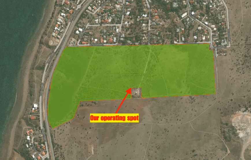
Above:- Aerial view of the park showing our operating spot. Image courtesy of Protected Planet.
Once we got to the lighthouse we took a breather and enjoyed the sensational views back towards the Adelaide CBD and along the Adelaide coastline.


There were also some sensational views out across the Gulf St Vincent towards Yorke Peninsula. There were quite a few boats out in the Gulf taking advantage of the fantastic weather.


For this activation we ran the Yaesu FT-857d set at 10 watts PEP for Marija, and 40 watts for me. Our antenna was a 80/40/20m linked dipole, inverted vee, supported on a 7m heavy duty telescopic squid pole.
Above:- ‘the shack’
Despite literature and signs stating that dogs may be walked in the park along designated trails, and that they must remain under your control on a lead at all times, this didn’t occur in practice at the park during our visit. We even had a woman walking her dog off the lead, with the dog running up to us and peeing alongside our table just after we had set up.
I started off the activation, with number one in the log being Geoff VK3SQ at Beechworth. This was followed by Julie VK3FOWL, Brett VK2FSAV and then Stuart (VK3STU) VK3SPL at the Split Point lighthouse. Sadly band conditions on 40m were less than ideal, with lots of fading (QSB) on signals. Many of the regular Victorian park hunters who are normally S9, were a number of S points lower. Ten contacts are required to qualify a park for the VKFF program, and these normally come very quickly. It took me 20 minutes to get to contact number 10, which was with Peter VK3KU.
I continued on until I had 44 contacts in the log. Contact number 44, qualifying the log for me for the global WWFF program, was with VK5BWR at the Point Lowly lighthouse near Whyalla. It was a little disappointing, as number one the band was in quite poor shape. And secondly there did not seem to be a lot of lighthouse stations on air. I had logged just 5 lighthouse activators. I had managed three Park to Park QSOs. They being with Stef VK5HSX/2 in VKFF-0065, Gerard VK2JNG/p in VKFF-1778, and Phil VK6CLL in VKFF-0283.


We then swapped ‘driver’s seats’, with Marija taking charge of the mic. The power was lowered down to 10 watts PEP, the allowable amount under Marija’s Foundation licence. Marija’s first contact after calling CQ was with VK5BWR at the Point Lowly lighthouse, followed by VK3OLS at the Cape Otway lightstation, and then Geoff VK3SQ. Marija’s 10th contact, qualifying the park for her for VKFF was with Garry VK7GG. Whilst I went off for a walk in the park, Marija continued on and had soon racked up 44 contacts. QSO number 44 for Marija was with Ken VK3UH. Marija had seven lighthouse stations in the log, and three Park to Park contacts.


I then jumped back on air on 40m, and logged a further 27 stations from Vk1, VK3, VK4, VK5, and VK7, including five more lighthouse stations and another Park to Park with Gerard VK2JNG/p who had moved to a new park, the Glenrock State Conservation Area VKFF-1319.
I took a short lunch break whilst Marija again took charge of the mic logging another 9 stations including VK3OLS at the Cape Otway lightstation AU-0011 and VK3ATL at Point Lonsdale lighthouse AU-0028.
After lunch I jumped back on the mic, and whilst activating, Ian VK5MA arrived to say g’day. Marija kept Ian company for about 20 minutes whilst I continued to work the steady pile. Eventually the callers dried up and it was a good opportunity of putting down the mic to say hello to Ian and catch up on his recent trip to VK6, where he activated a number of parks.
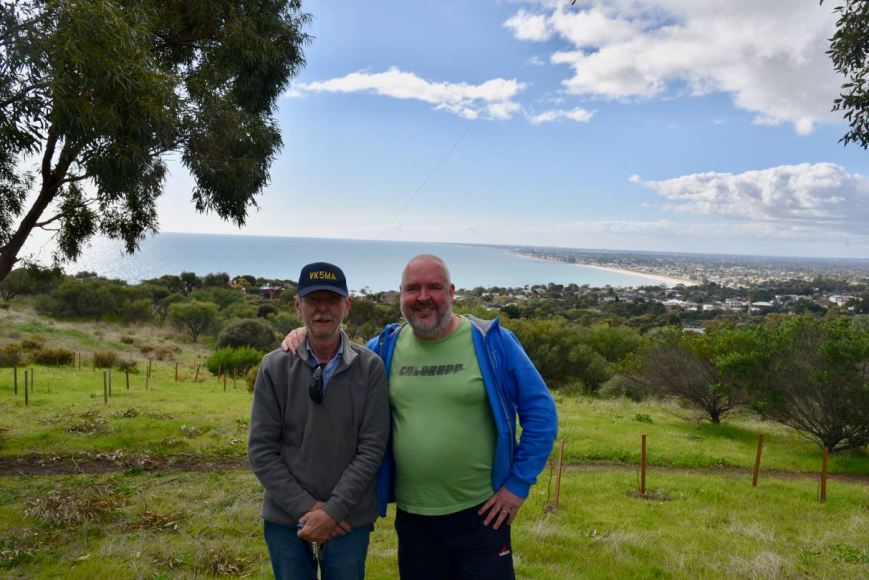
Above:- with Ian VK5MA. Adelaide in the background.
After Ian had left, I tried my luck on the 80m band. Although there had been a small opening on 40m locally, I was hoping to work a lot more VK5’s on 80m. Sadly, I logged just 4 stations on 80m, with one of those being VK5ARC at the Point Malcolm lighthouse. It was a real shame that there were not more callers as the band conditions on 80m were excellent.
I then headed to 14.310 on the 20m band where I logged 13 stations, including a few more lighthouse stations. My only DX worked on 20m was with Barrie W7ALW in Montanna. No long path Europe was heard. Being at the bottom of the solar cycle means that the pile up from Europe which I experienced from many parks years ago, is certainly a thing of the past. Lets hope conditions improve!
I then moved back to 40m where I logged a further 48 stations. This included a nice contact with ZL1LIG at the Cape Reinga lighthouse NZ-0020 at the very top of the North Island of New Zealand. As it was now late afternoon, the European & USA stations were starting to come through. I had 2 USA stations come up on 7.140 where I was operating, with one of those being very loud. I apologise to those who were calling that I wasn’t able to pull through, as the QRM was just too great. I boxed on for a few minutes before QSYing to 7.137 where I worked 5 stations before going QRT.
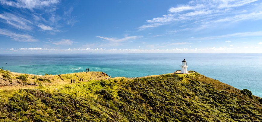
Above:- Cape Reinga lighthouse. c/o http://www.backpackerbus.co.nz
It was fast approaching 5.30 p.m. local time and it was starting to get very cold. The temperature had dropped dramatically to around 8 deg C. I had pushed my luck with Marija, having been in the park all day. Marija and I packed up, with a total of 210 contacts in the log, including 22 different Australian lighthouses and one NZ lighthouse. Amongst that were also 10 Park to Park contacts. Whilst packing up and walking back to the vehicle we enjoyed a magnificent sunset.


We worked the following lighthouses:-

Marija worked the following stations on 40m SSB:-
I worked the following stations on 40m SSB:-
I worked the following stations on 80m SSB:-
I worked the following stations on 20m SSB:-
References.
Birds SA, 2017, <http://www.birdssa.asn.au/location/marino-conservation-park/>, viewed 20th August 2017
Cockburn, R., 2002, ‘South Australia What’s in a Name?’
Nicol; S., 1997, Adelaide Region RAA Touring book
Professional Historians Australia, 2017, <http://www.sahistorians.org.au/175/chronology/november/17-november-1912-wonga-shoal.shtml>, viewed 20th August 2017
SeaSide Lights, 2017, <http://www.seasidelights.com.au/au/sa/marinorocks.asp?fState=SA>, viewed 20th August 2017
State Library South Australia, 2017, <http://www.samemory.sa.gov.au/site/page.cfm?u=638&c=2684>, viewed 20th August 2017
Wikipedia, 2017, <https://en.wikipedia.org/wiki/Marino_Conservation_Park>, viewed 20th August 2017
Wikipedia, 2017, <https://en.wikipedia.org/wiki/Marino,_South_Australia>, viewed 20th August 2017
Wikipedia, 2017, <https://en.wikipedia.org/wiki/George_Strickland_Kingston>, viewed 20th August 2017
Yesterday (Monday 14th August 2017) I commenced a few days off from work, and as it was such a beautiful sunny day I decided to head down to Port Adelaide and activate one of the newly added parks for the World Wide Flora Fauna program, the Adelaide Dolphin Sanctuary VKFF-1880. This was to be the first time that this reference was put on air.

Above:- Map showing the location of the Adelaide Dolphin Sanctuary. Map courtesy of Google maps.
The Adelaide Dolphin Sanctuary is located near Port Adelaide. You could spend days here wandering around the streets of the Port. Port Adelaide is well known for its well preserved 19th century buildings which reflect the maritime history of the area.


Amongst the many things to see is the and the Clipper ship, the City of Adelaide, which is the world’s oldest surviving clipper ship. The City of Adelaide was built in Sunderland, England, and launched on 7th May 1864. The ship was commissioned in the Royal Navy as HMS Carrick between 1923 and 1948 and, after decommissioning, was known as Carrick until 2001. At a conference convened by HRH The Duke of Edinburgh in 2001, the decision was made to revert the ship’s name to City of Adelaide, and the duke formally renamed her at a ceremony in 2013.
When the City of Adelaide was decommissioned she was towed to the River Clyde in Scotland where it remained until 1991, when she sank. She was recovered by the Scottish Maritime Museum and remained there in the slipway until the Scottish Maritime Museum was issued an eviction notice by the owners of the slipway.
In 2010, the Scottish Government decided that the ship would be moved to Adelaide, to be preserved as a museum ship. In September 2013 the ship moved by barge from Scotland to the Netherlands to prepare for transport to Australia. In late November 2013, loaded on the deck of a cargo ship, City of Adelaide departed Europe bound for Port Adelaide, Australia, where she arrived on 3 February 2014.


Port Adelaide is a busy port, although a large amount of the very large ships now berth at Outer Harbor.


Also located close to the sanctuary is the Adelaide Submarine Corporation, a naval shipbuilder for the Royal Australian Navy’s Collins class submarines and Hobart class destroyers.


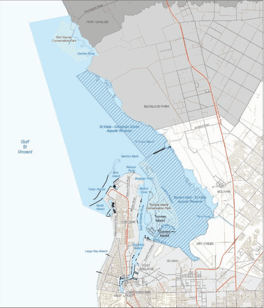
The Adelaide Dolphin Sanctuary was established in June 2005 as a result of community concerns about the safety of the dolphins living in the Port Adelaide River and Barker Inlet and their environment. During 2002 the South Australian Government undertook public consultation to gain an understanding of how the community wanted the dolphins cared for. As a result of overwhelming support, the Parliament proclaimed The Adelaide Dolphin Sanctuary Act 2005.
The sanctuary which is known as one of the best and most easily accessible Dolphin Sanctuaries in the world, consists of an area of 118 square kilometres and is located on the eastern shore of Gulf St Vincent. The sanctuary includes the Port Adelaide River and Barker Inlet and from there it stretches around to North Haven Marina, then north around Outer Harbor and up the coast to the Port Gawler Conservation Park. The area includes a 10,000 year old mangrove forest, seagrass, saltmarsh, tidal flats, tidal creeks and estuarine rivers, all of which combine to provide habitat for dolphins and their food resources.
The sanctuary is home to around 30-40 resident Indo-Pacific bottlenose dolphins. Around 300 or so dolphins are thought to regularly visit the area. This species of dolphin grows to 2.6 metres (8.5 ft) long, and weighs up to 230 kilograms. They are not to be confused with Common bottlenose dolphins. Indo-Pacific bottlenose dolphins live in groups that can number in the hundreds, but groups of five to 15 dolphins are most common. Their life span is around 40 years. Dolphins can dive to depths of more than 500 metres, but they must surface for air every few minutes. Like whales, dolphins breathe through a blowhole on the top of their heads.

A Port River dolphin. Image courtesy of Wikipedia.
Other wildlife located in the sanctuary include Long nosed fur seals, Southern Eagle Rays, and the endangered Australia Sea Lion.
The area is also a popular bird watching site and shares most of its northern coastal habitat with the Adelaide International Bird Sanctuary. The sanctuary is home to many species of birds including some rare and endangered species. More than 250 species have been recorded. Certainly during my visit, the area was alive with birdlife. Some of those that I observed are captured in the photographs below.
The dolphins within the sanctuary are regularly under threat. This includes marine litter and entanglement, harrassment and disturbance, disease, habitat degradation and pollution, and vessel strikes and noise. Human activities include dredging, boat-generated wave action, anchoring, bait digging, illegal rubbish dumping, human foot traffic, industrial discharges, stormwater runoff, construction of wharves and shore reclamation. Discarded fishing gear poses a high threat to dolphins within the sanctuary, with a number of dolphins having become entangled by fishing line, nets and rope.
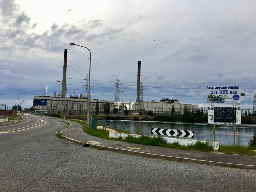
Above:- the nearby power station.
I decided to travel down Grand Trunkway and onto Garden Island. The island was a major landfill site until 2001. Garden Island is well known as being a ship’s graveyard. Instead of scuttling obsolete vessels in deep water, the South Australian Harbours Board decided that an easier and cheaper option was to beach and further dismantle the stripped hulks at Garden Island. There are a total of 25 wrecks known to have been abandoned at Garden Island.
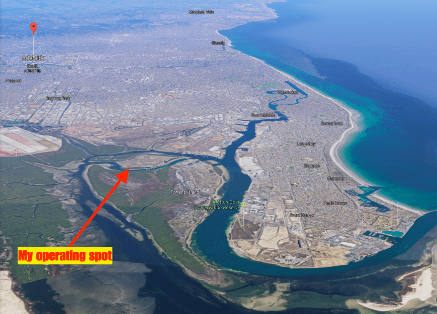
Above:- Aerial view of the Adelaide Dolphin Sanctuary, showing my operating spot. Image courtesy of Google maps.
I travelled to the end of Garden Island Road and set up on the lawned area close to the waters edge, overlooking Angus Inlet. As it was a warm and sunny day, this was an ideal place to set up, underneath the shade of the trees.
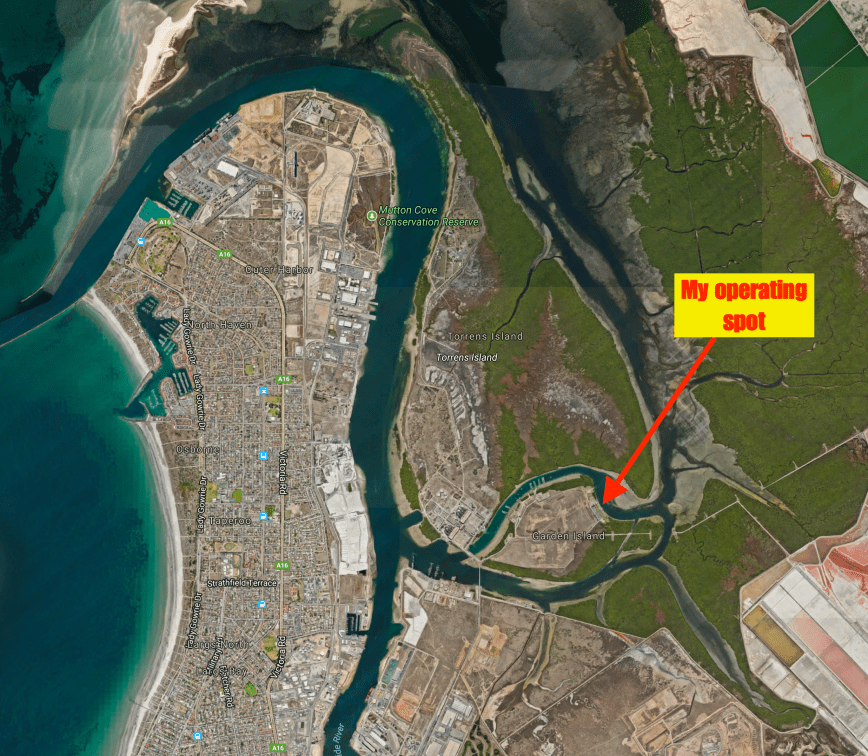
Above:- Aerial shot showing my operating spot. Image courtesy of Google maps.
I was a little worried about potential noise, as the power station was nearby, along with the huge power lines running out of the station to Adelaide. And my fears were confirmed when I switched on the Yaesu FT-857d. I had strength 8 noise. I decided to box on and put up with the noise, rather than packing up and relocating. I suspect that most operating spots in the sanctuary would be noisy due to the large amount of industry in the area.
First in the log was Yern VK2KJJ, followed by Dennis VK2HHA, and then Tom VK5ZTS in the northern suburbs of Adelaide. Tom had a great 5/9 + signal. It was clear that propagation into Adelaide was going to be good during this activation, due to ground wave. Contact number 10, qualifying the park for me for VKFF was with Nik VK3NLK, about 15 minutes into the activation.


The noise floor did drop to strength 7 during the activation, but it was still very hard going pulling out some of the lower signals. I apologise to those who were calling that I was unable to work. I know there were a number of stations who called that I was just unable to pull through the noise.
I logged a total of 47 stations on the 40m band from VK2, VK3, VK4, VK5, VK6 and VK7. I then called CQ on 3.610 on the 80m band where I logged 3 contacts. They being with Ron VK5MRE in the Riverland, who had followed me down from 40m. Also Greg VK5GJ in the Adelaide Hills and Yern VK2KJJ in Wagga Wagga. Very pleased with that contact considering the time of day on 80m.
To wrap up the activation I called CQ on 14.310 on the 20m band. Unfortunately Rick VK4RF/VK4HA was the only station logged there.


Whilst activating I observed a number of dolphins cruising by in Angus Inlet.


After just short of 2 hours in the park it was time to go QRT and head for home. I had a total of 52 contacts in the log and another unique park to add to my activator tally.
I worked the following stations on 40m SSB:-
I worked the following stations on 80m SSB:-
I worked the following stations on 20m SSB:-
References.
Department for Environment and Heritage, 2007, Adelaide Dolphin Sanctuary Management Plan.
Department of Environment Water and Natural Resources, 2017, <https://www.environment.sa.gov.au/our-places/Heritage/maritime-heritage/visiting-shipwrecks/shipwreck-trails/Garden_Island>, viewed 15th August 2017
Government of South Australia, 2014, Adelaide Dolphin Sanctuary users Guide
National Parks South Australia, 2017, <https://www.environment.sa.gov.au/parks/Find_a_Park/Browse_by_region/Adelaide/adelaide-dolphin-sanctuary>, viewed 15th August 2017
Wikipedia, 2017, <https://en.wikipedia.org/wiki/Port_Adelaide>, viewed 15th August 2017
Wikipedia, 2017, <https://en.wikipedia.org/wiki/Indo-Pacific_bottlenose_dolphin>, viewed 15th August 2017
On the weekend just gone I was working afternoon shift and as a result would not be able to compete in the Remembrance Day Contest. This was a real shame as the weather was fantastic and I was hoping to go portable for the contest. So instead I decided for a quick morning activation on Saturday 12th August 2017.
I headed to the Nurragi Conservation Reserve VKFF-2247, which is located about 70 km south east of Adelaide. This is a newly added park to the World Wide Flora Fauna (WWFF) program, and my activation would be the first time the park had been put on air.
Above: Map showing the location of the Nurragi Conservation Park, south east of Adelaide. Map courtesy of Location SA Map Viewer.
The Nurragi Conservation Reserve follows the old branch railway line to Milang and runs a distance of about 12 km, from Sandergrove to Milang. The park is about 65 hectares in size. The Friends of Nurragi was established in 1988 to protect and restore the reserve and in 1991 the Minister of Lands dedicated the area as a Nature Conservation and Plantation Reserve under the Crown Lands Act 1929.


The reserve forms a wildlife corridor linking the eastern Mount Lofty Ranges with Lake Alexandrina and contains extremely important vegetation in a region that has been cleared of over 98% of its original cover. More than 300 native plant species are present, with over 50 of those being of particular conservation significance (eg rare or endangered). It preserves remnant mallee vegetation including square-fruited mallee, narrow-leaved red mallee, peppermint box, and native apricot. Understorey plants include wallowa, needle bush wattle and broombush.


")
During my visit there were a few flowering native plants, particularly the wattles, which were vivid yellow.


Over 95 species of birds have been recorded in the park including Peaceful Dove, Weebill, Australian Magpie, Little Raven, Grey Shrikethrush, Diamond Firetail, Southern Boobook, Red-capped Robin, Hooded Robin, and Rufous Whistler. Native mammals found in the park include Western Grey kangaroos, Brush-tailed possums and bats. About 11 reptile species have been recorded including the Sand Goanna.
During my visit the park was alive with New Holland Honeyeaters and Superb Fairy Wrens. I also spotted a Shrike Thrush (I think?)


I was pleasantly surprised to find a number of interpretive signs in the park, no doubt the result of the hard work of the Friends of Nurragi.


The park commences at the town of Milang, which is located on the banks of Lake Alexandrina. Between 1860 and 1880 Milang was one of South Australia’s busiest ports. It connected Adelaide with the thriving river trade. Wool from the Darling and Upper Murray stations was landed at Milang and then transported by horse and bullock teams to Port Adelaide. Wheat was transported to Milang, processed at its flour mills and then shipped back as flour.


A number of historic buildings remain in Milang. But sadly, an impressive group of Landseer buildings which stood in the main street were demolished in the 1950’s and replaced by the present day shopping centre. What a great shame! Albert Landseer was one of South Australia’s principal river merchants.

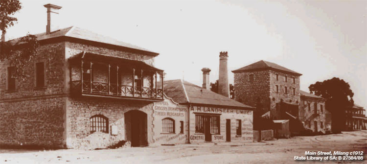
Above:- Milang in the late 1800’s. Image courtesy of http://www.milang.org.au
Above:- the former Landseer buidlings in the main street of Milang. Image courtesy of http://www.murrayriver.com.au
In May 1854, the first public railway in South Australia was completed, linking Goolwa and Port Elliot. The success of the Goolwa-Port Elliot line aroused interest in Strathalbyn where local business men saw advantages for them in a direct link with the new port at Victor Harbor. In 1857 a group of 20 people attended a meeting at the Lake Hotel in Milang, in support of a line from Strathalbyn to Milang. Unfortunately a larger meeting at Strathalbyn resulted in confirmation that the line would run from Strathalbyn to Middleton on the south coast.
In 1881 there was a new push for a branch line to Milang. A Select Committee was appointed by the South Australian Government. On the 8th November 1881 the House of Assembly passed the ‘Strathalbyn and Milang Railway Bill’. Tenders for the construction of both lines were called on the 18th April 1882 and Walker and Swann were successful in obtaining the joint contract for a price of ₤143,678.
The Milang branch line was opened on the 17th December 1884 from a junction with the Victor Harbor line at Sandergrove. At Sandergrove the Milang line served as the passing siding for the station, sharing an island passenger platform with the Victor Harbor main line. A goods siding also catered for local goods consignments. The only intermediate station was at Nurragi where there was a 70m long goods siding. There was also a passenger stop at Punkulde where the line crossed the Milang-Finniss road.
At one stage there was a small turntable at Sandergrove to turn locomotives working to Milang. Through most of its later life the branchline was operated with Brill railcars. The last passenger service ran 30 November 1968 with the line closed on 17th June 1970.
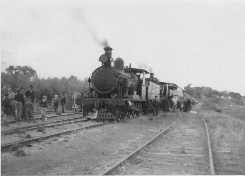
Above:- a loco on the Milang branch line
If you are in Milang I highly recommend a visit to the Port Milang Historic Railway Museum. The museum is located on the banks of Lake Alexandrina and tells the story of the Lakes Railways, displays a collection of South Australian rolling stock and equipment.


Although the Milang line has long since closed, the line between Mount Barker where I live, and Victor Harbor, is still used by SteamRanger Heritage Railway which runs a number of different heritage steam and diesel hauled tourist trains through the Adelaide Hills and along the South Coast to Victor Harbor.

Above:- the Mount Barker to Victor Habor line.
I set up right in the middle of the park, off Nurragi Road. There was a small area here off the road for me to park the vehicle, and make a short walk to where I set up. I ran my normal portable set up for this activation consisting of the Yaesu FT-857d, 40 watts output, and the 80/40/20m linked dipole, inverted vee at 7 metres at the apex.
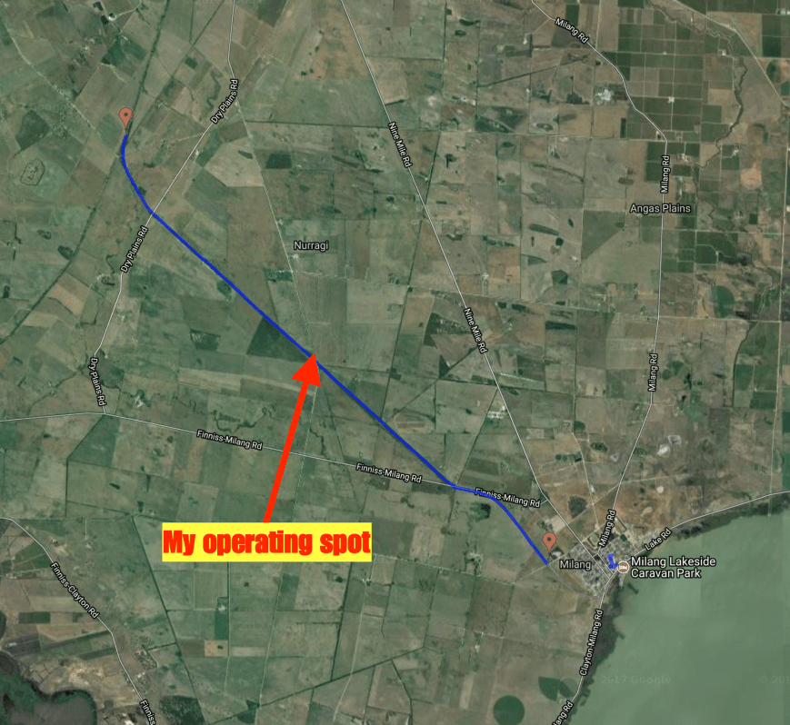
Above:- Aerial shot of the park (indicated in blue), showing my operating spot. Image courtesy of http://www.railtrails.org.au
I was all set up and ready to go by around 9.30 a.m. local time. First in the log was Peter VK3PF, who is well and truly leading the pack when it comes to park hunters in Australia. Next was another keen park hunter, Dennis VK2HHA from Albury, followed by my good wife Marija VK5FMAZ. It was very slow going and I had real doubts that I was not going to reach my 44 contacts which are required to qualify the park for the global WWFF program. Contact number 10, qualifying the park for me for the VKFF program, was with Kevin VK3HKK.
Shortly afterwards I worked Stef VK5HSX who was portable in the Girraween National Park VKFF-0198. It is always nice to get a Park to Park contact in the log during an acivation. I went on to work a total of 22 stations on the 40m band before callers dried up. I headed over to the 80m band where I called CQ on 3.610. This was answered by John VK5NJ in Mount Gambier who was booming in at 5/9 +. Mark VK5QI then called, followed by Les VK5KLV at Port Augusta in the north of South Australia, and then Mick VK3GGG/VK3PMG in western Victoria.
I then headed back to the 40m band where I logged a further 31 stations from VK2, VK3, VK4, VK5, and VK7. My 44th contact came at 90 minutes into the activation, with a QSO with Andrew VK5MR at Roxby Downs in the north of South Australia.


I then headed back to 80m hoping to get my wife Marija VK5FMAZ in the log. She had just arrived home from shopping and we had corresponded via SMS. Marija was my first taker after calling CQ, followed by David VK5PL in the Barossa Valley and then Wolf VK5WF in Adelaide. I then worked Geoff VK3SQ at Beechworth in north eastern Victoria, John VK5BJE in the Adelaide Hills, and finally Allen VK3ARH. More proof that 80m works very well, even in the middle of the day.
I then received a SMS message from David VK5KC to advise he was portable in a park on the Eyre Peninsula. So I quickly lowered the squid pole and removed the 80m links and headed to 7.144. I logged David who was activating the Laura Bay Conservation Park VKFF-1048.
I then tried my luck on 20m. It was too early for any DX, but I did log a total of 4 stations from VK4 and VK6. To finish off the activation I moved back to 7.135 on 40m where I picked up 2 more stations.
It was approaching 12.30 p.m. and I needed to pack up and head home for some lunch and a shower, and then off to work. I had a total of 71 contacts in the log and another unique park activated. Thanks to everyone who called and thanks to those who spotted me.
I worked the following stations on 40m SSB:-
I worked the following stations on 80m SSB:-
I worked the following stations on 20m SSB:-
References.
Birds SA, 2017, <http://www.birdssa.asn.au/location/nurragi-conservation-reserve/>, viewed 11th August 2017
Milang, 2017, <http://milang.org.au/history/>, viewed 14th August 2017
National Trust, 2017, <https://www.nationaltrust.org.au/places/nurragi-conservation-reserve/>, viewed 11th August 2017
Steamranger, 2017, <http://www.steamranger.org.au/enthusiast/guides/guide7.htm>, viewed 11th August 2017
Walking SA, 2017, <https://www.walkingsa.org.au/walk/find-a-place-to-walk/nurragi-conservation-reserve-walking-trail/>, viewed 11th August 2017
I had a day off today (Saturday 29th July 2017) after a few afternoon shifts, and despite it being a rather unpleasant day outside, I decided late in the morning to head over to the Charleston Conservation Park 5CP-041 & VKFF-0777. The park is just a short 23 km drive by road from my home, and about 46 km east of Adelaide.
Above:- Map showing the location of the Charleston Conservation Park in the Adelaide Hills. Map courtesy of Location SA Map Viewer.
I have activated the park many times previously, so today’s activation was mostly for the recently released Boomerang Award in the VKFF program, which encourages park activators to head back to the same park.
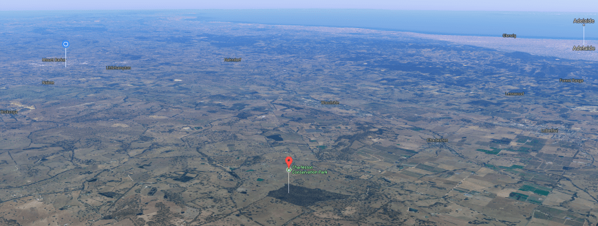
Aerial shot showing the park, with my QTH to the left of the shot. Adelaide is in the background. Image courtesy of Google maps.
Charleston is 54 hectares in size and was first proclaimed on the 8th April 1976. Most of the habitat within the park is Woodland with either Manna Gum or Rough-barked Manna Gum over Golden Wattle.
Over 100 species of bird have been recorded in the park including Adelaide Rosella, Striated Pardalote, Australian Golden Whistler, Grey Shrikethrush, Willie Wagtail, Australian Magpie, and Painted Buttonquail.
The park is located about 8 km east of the little town of Charleston, which was laid out in 1857 by Charles Dunn (1796–1881), a brother of the prominent miller John Dunn. It is believed the town was originally known as “Charlestown”, but the current spelling has always been more common in newspaper reports.


I travelled along some of the ‘back roads’ to get to the park. As it is winter, the countryside was beautitful and green.


I soon reached the park on Bell Springs Road. This is the only way to access the park. There is a small car parking area at gate one. As I was pulling up at the park I worked Gerard VK2JNG who was portable in the Kwiambal National Park VKFF-0274


I set up on the boundary track on the western side of the park. My usual portable gear was used for this activation: Yaesu FT-857d, 40 watts, and the 20/40/80m linked deipole, inverted vee @ 7 metres.
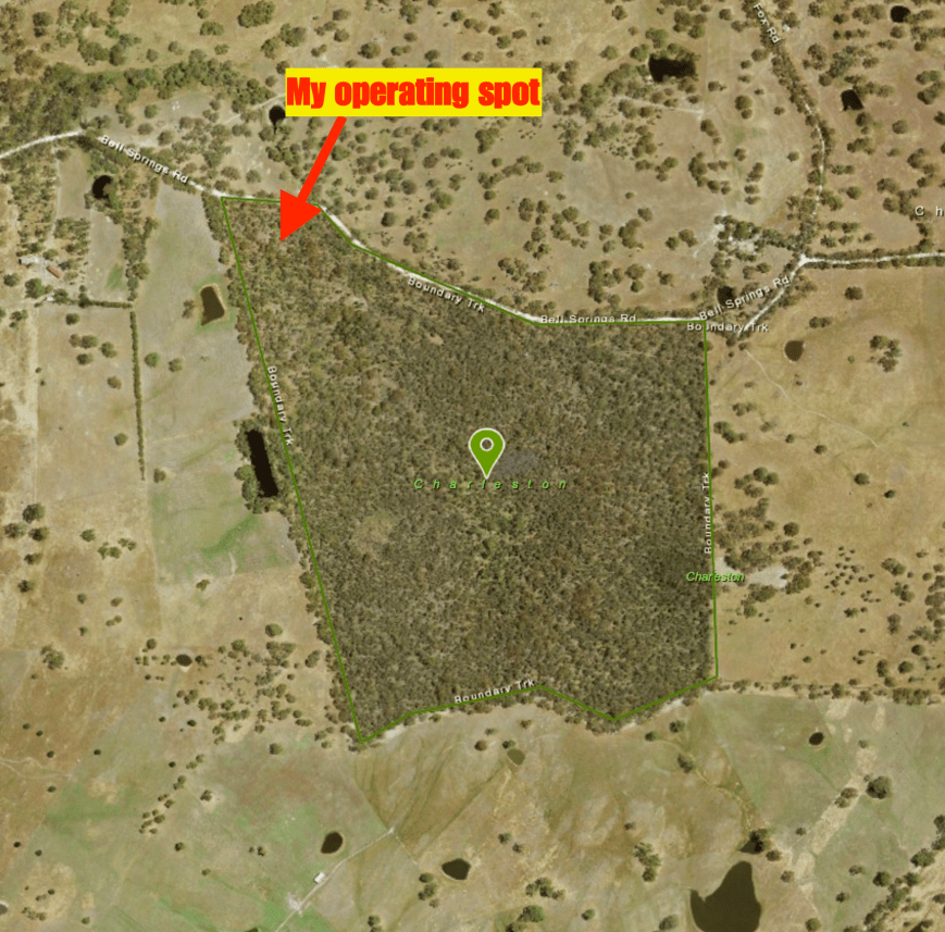
Above:- Aerial shot of the park showing my operating spot. Image courtesy of Location SA Map Viewer.
It was incredibly windy with a very nasty storm front approaching from the west. As a result it took me a little longer than normal to get set up, as I continually got the antenna caught up in the branches of the gum trees. I headed to 7.144 hoping to get a Park to Park with Gerard VK2JNG, but there was silence. I asked if the frequency was in use and I was very pleased to hear Gerard come back to me to advise that he was waiting for me. I logged Gerard who was an excellent 5/9 signal.
I then headed down to 7.139 and asked if the frequency was in use, with Dennis VK2HHA coming back to advise that it was all clear. I logged Dennis, followed by Peter VK3PF, Marija VK5FMAZ, and then Rick VK4RF/VK4HA. Despite it being a weekend, there was not the normal flurry of callers. More like a constant flow. Contact number 10 was with Steve VK7CW after 10 minutes of being on air in the park.
I had 24 contacts in the log when I was approached by 2 bushwalkers and a young child. They showed great interest in what I was doing. Thanks to those who patiently waited whilst I was chatting and explaining the hobby to them. They were extremely amazed hearing such strong signals coming in from interstate.


When things slowed down a little I took the opportunity of heading down to 7.090 where I had seen a spot on parksnpeaks for Matt VK1MA/2 on a SOTA peak. When I first heard Matt he was a good 5/7, but within a minute I had almost lost him. Sadly I wasn’t able to make contact with Matt. So I headed back up to 7.139 where I logged a further 4 stations.
As I had very few callers I headed back to 7.090 where I managed to get through to Matt after a few goes. I was hearing Matt okay at 5/3, but he was struggling with my signal, 3/3, at his end. But we made it.
I then headed off to the 20m band where I called CQ after self spotting on parksnpeaks. Unfortunately my only contact on 20m was with Anthony VK6MAC in Western Australia.
The weather was moving in fast, so I decided to try my luck on the 80m band. I called CQ and received a call from Geoff VK3SQ at Beechworth. I was able to hear Geoff quite well as there was no noise in the park, but sadly Geoff was unable to hear me. First in the log on 80m was my wife Marija VK5FMAZ, followed by Tony VK5MRT, and finally David VK5PL.
I decided to have one last listen on 40m before calling it quits for the day. Unfortunately I couldn’t get back onto 7.139 as there were some stations there already, and I had to go up to 7.150 as one of those stations was very wide. I logged a further 4 stations including Owen VK2AEJ/p at the Cape Don lightship in Sydney. The MV Cape Don is a former lighthosue tender, now a museum ship in Waverton in New South Wales.
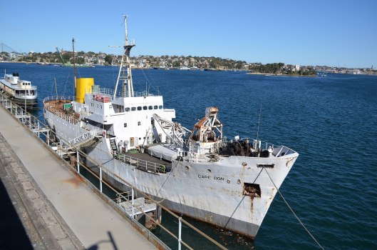
Above: the MV Cape Don. Image courtesy of wikipedia
It was time to go QRT as I was just starting to experience some drops of rain. I had a total of 44 contacts in the log.
After packing up I went for a walk along the boundary track on the western side of the park. I highly recommend this, as the park becomes very picturesque as you get further into the park. I came across a few fenced off areas in the park and some other marked out areas. Not sure what they were for?


I worked the following stations on 40m SSB:-
I worked the following station on 20m SSB:-
I worked the following stations on 80m SSB:-
References.
Birds SA, 2017, <http://www.birdssa.asn.au/location/charleston-conservation-park/>, viewed 29th July 2017
Wikipedia, 2017, <https://en.wikipedia.org/wiki/Charleston,_South_Australia>, viewed 29th July 2017
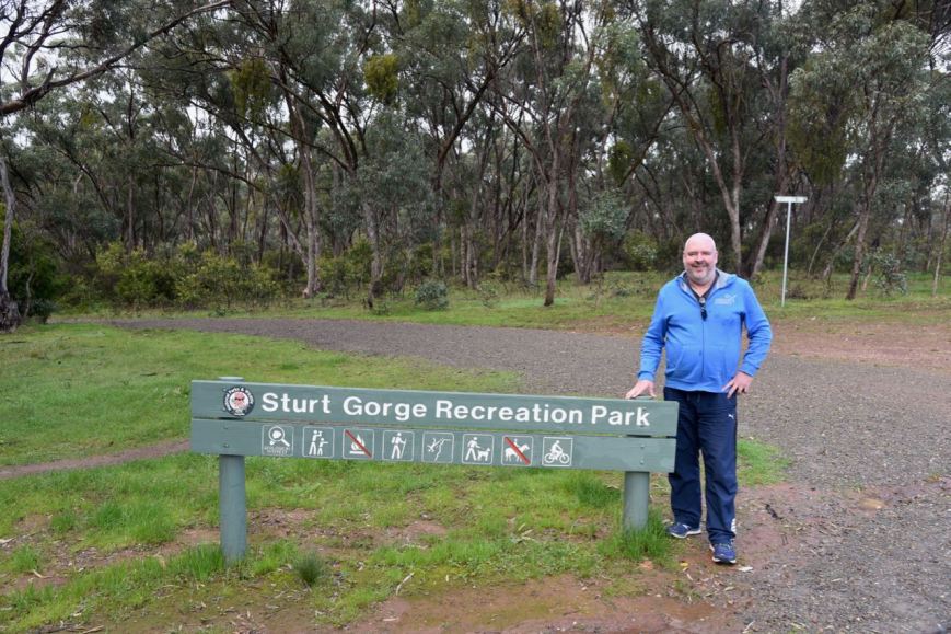
Today (Sunday 23rd July 2017) Marija VK5FMAZ and I activated the Sturt Gorge Recreation Park VKFF-1750. The park is located about 13 km south of Adelaide.
It was quite a miserable day compared to the day before which was bright and sunny. But despite the rather gloomy weather, we decided to head out. We had attended a friend’s house the night before for dinner for an event called ‘The Longest Table’, the Hospital Research Foundation’s annual cancer fundraiser. I had indulged in more than a bit of red wine, so I figured some fresh air would be of benefit to me
Above:- Map showing the location of the Sturt Gorge Recreation Park. Map courtesy of Location SA Map Viewer.
The Sturt Gorge Recreation Park is 244 hectares (600 acres) in size and was established on the 4th October 1973. The park lies between the suburbs of Bellevue Heights and Flagstaff Hill along the Sturt River.
During the 1964, Mr. Robin Millhouse, the Member for Mitcham (later to become the Attorney General of SA) raised the issue in Parliament of acquiring Sturt Gorge for use as a National Park. In a letter to the Minister of Lands dated 6th August 1964 Millhouse stated:
“The area I have in mind is that below the flood control dam site. I am sure you would agree that it is most suitable for a National Park”.
Unfortunately no action was taken by the Government, and in January 1966, Millhouse again raised the question with the new Minister of Lands, Mr. J.D. Corcoran. They both visited the area and later requested action be taken under the Town Planning Act to ensure that no subdividing for housing took place in the area. Unfortunately no powers exited at the time for this, and several applications to subdivide were received in 1965-1966.
Millhouse then had discussions with the de Rose family who owned the land and found the property was available for sale at the price of 70,000 pounds. Millhouse conveyed this information to the State Government who replied stating:
“The present Government is unable to contemplate the purchase of the area at this stage”.
In June 1966, Millhouse again raise the matter in Parliament, and in the following month, the de Rose family were approached by land developers and subsequently sold the land. Millhouse continued to apply pressure, and was supported by a campaign by the Geological Monuments Subcommittee of the S.A. Division of the Geological Society of Australia. Between 1969 and 1972, the applied pressure appears to have paid off, with the State Government purchasing in pieces the land from the two development companies. In 1973 the Sturt Gorge was proclaimed as a Recreation Park.

Above:- Robin Millhouse. Image courtesy of http://www.adelaidenow.com.au
The park is internationally recognised as an area of conservation and geological significance. Sturt Gorge conserves the nationally threatened greybox grassy woodland vegetation which was once abundant across southern Australia. It is the second largest remnant area of grey box open woodland managed by the Department of Environment Water & Natural Resources. Along the Sturt River there are numerous River Red Gums. North of the river there are areas of drooping sheaoak woodland over twiggy daisy-bush and sticky hop-bush. At the western end of the park the habitat is mostly exotic with some native grasses.


The park is also home to a rock formation, known as sturt tillite, that is believed to have been formed from glacial material dropped from ice floating in the ocean that covered South Australia 800 million years ago.
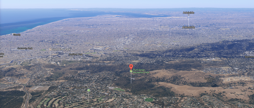
Above:- Aerial view of the park, in close proximity to Adelaide. Image courtesy of Google maps
The Sturt River, also known as Warri Parri, carves its way through the park. The river rises in Upper Sturt and flows through Corromandel Valley, the Sturt Gorge Recereation Park, the southern suburbs of Marion and Morphettville, before meeting the Patawalonga River in Glenelg North, the end of its 27 km course. It was named after the famous explorer, Captain Charles Sturt.
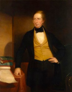
Above:- Captain Charles Sturt. Image courtesy of wikipedia.
The Sturt River Flood Control Dam can be located in the park. It is well worth a look, as there are some great views of the gorge from the 40 metre high dam wall. But beware, the walk back up to the car park area is quite steep.


Over 115 species of bird have been recorded in the park including Crimson Rosella, Superb Fairywren, New Holland Honeyeater, Red Wattlebird, Whiteplumed honeyeater, White-browed Babbler, Grey Shrikethrush, Peregrine Falcon, and Sacred Kingfisher.
The park is also home to a large amount of native wildlife including kangaroos and koalas.
For more information on the park, have a look at the Friends of Sturt Gorge website at…..
http://www.fosg.org.au/park.html
Marija and I operated from inside gate 20 at the end of Craigburn Road. We ran the Yaesu FT-857d (set at 10 watts PEP for Marija, and 40 watts for me), and the 80/40/20m linked dipole supported on the 7 m squid pole, inverted vee.
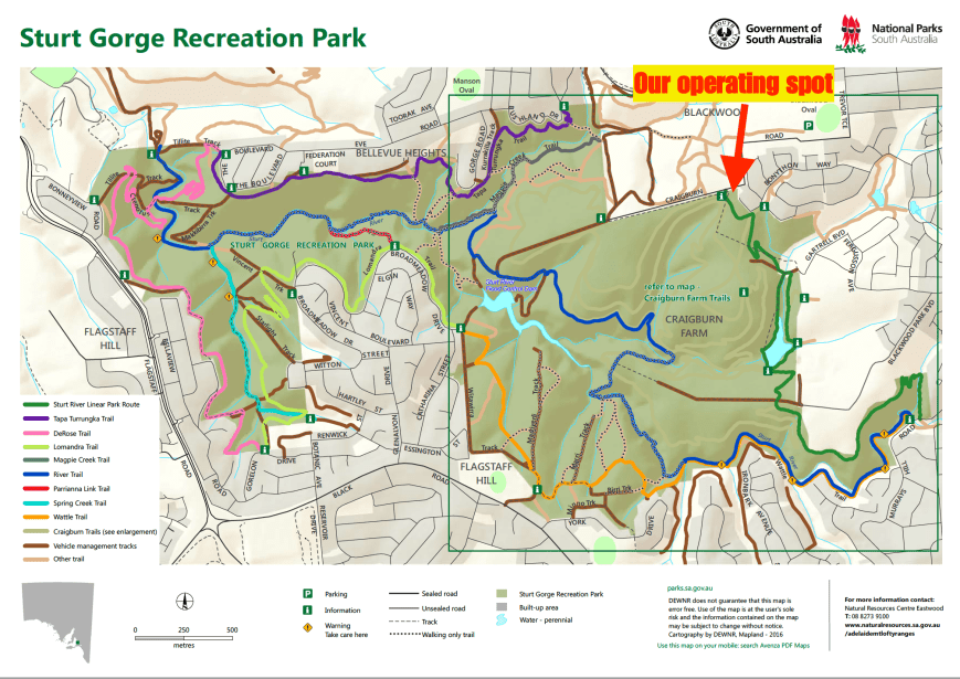
Above:- Map of the Sturt Gorge Recreation Park showing our operating spot. Map courtesy of National Parks South Australia.
This was to be a unique park for both Marija and I for the World Wide Flora Fauna (WWFF) program. Marija started off the activation and was content in obtaining 10 QSOs, qualifying the park for the VKFF program. We headed to our nominated operating frequency of 7.144 and found Gerard VK2JNG/p who was activating the Rocky Glen National Park VKFF-1179. We both logged Gerard, Park to Park, and then headed down to 7.135 where Marija called CQ. Marija’s second contact was another Park to Park, this time with Peter VK3PF/p in the Glenmaggie Regional Park VKFF-1877.
Marija had soon racked up 10 contacts, thus qualifying the park for VKFF. Contact number 10 being with Adam VK2YK. Shortly after we also worked Neil VK4HNS/p who was activating theSpringwood Conservation Park VKFF-1653. Marija logged a total of 13 stations from VK2, VK3, VK4,, and VK7, before we swapped the mic.


I then called CQ on 7.135, with my first taker being Lee VK2LEE, followed by Ron VK3MRH, and then Dennis VK2HHA. Contact number 10, with Steve VK7CW, soon followed. Despite it being a Sunday, there was not the normal flurry of callers. Band conditions also seemed to be down a little, with quite a bit of QSB on the signals. But despite this, I logged my 44th contact, a little over an hour into the activation. Contact number 44 was with Murray VK3MJT.
Whilst I was on air, Marija had a number of chats with interested onlookers, explaining what we were doing and all about the hobby of amateur radio. Park activating is always a great way of promoting the hobby.
I logged a total of 46 stations on 40m from VK2, VK3, VK4, VK5, VK6, and VK7, before we lowered the squid pole, and inserted the 80m links. I called CQ on 80m with John VK5BJE coming back with a very solid 5/9 + signal. But sadly John was my only caller on 80m.
The weather was becoming quite threatening, and it was a chilly 13 deg C, so I quickly tried my luck on 14.310 on the 20m band. Anthony VK6MAC was my first caller there with a good strong 5/8 signal from Western Australia, followed by Fred VK4FE in far north Queensland, and then Hans VK6XN. Sadly I had to go QRT very quickly with Hans as the heavens opened up. It was mad dash to pack up the gear and head back to the vehicle.


It was time to head home. We had both successfully qualified the park for VKFF and I had also achieved 44 QSOs, qualifying the park for the WWFF global program. And a brand new park to add to our activator list. Thanks to everyone who called.
Marija worked the following stations on 40m SSB:-
I worked the following stations on 40m SSB:-
I worked the following station on 80m SSB:-
I worked the following stations on 20m SSB:-
References.
Birds SA, 2017, <http://www.birdssa.asn.au/location/sturt-gorge-recreation-park/>, viewed 23rd July 2017
Friends of Sturt Gorge, 2017, <http://www.fosg.org.au/index.html>, viewed 23rd July 2017
National Parks South Australia, 2017, <https://www.environment.sa.gov.au/parks/Find_a_Park/Browse_by_region/Adelaide/sturt-gorge-recreation-park>, viewed 23rd July 2017
Wikipedia, 2017, <https://en.wikipedia.org/wiki/Sturt_Gorge_Recreation_Park>, viewed 23rd July 2017
Wikipedia, 2017, <https://en.wikipedia.org/wiki/Sturt_River>, viewed 23rd July 2017
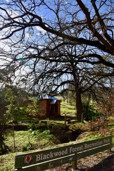
Yesterday (Saturday 22nd July 2017) I activated the Blackwood Forest Recreation Park VKFF-1686 which is located about 13 km south of Adelaide, in the Mount Lofty Ranges ‘Adelaide Hills’. The park is located at Hawthorndene in the Coromandel Valley.
This was to be a unique park for me as an activator for the World Wide Flora Fauna (WWFF) program, and the very first time the park had been activated.
Above:- Map showing the location of the Blackwood Forest Recreation Park. Map courtesy of Location SA Map Viewer.
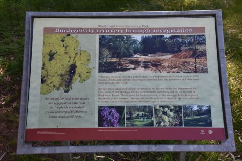
The Blackwood Forest Recreation Park was first acquired by the South Australian State Government in 1908 for use as an experimental orchard. It continued to be used for horticultural research until the 1960s. From the mid 1980’s there was sustained public concern over a period of more than 15 years, seeking to have the 21 hectares of land retained as open space. This resulted in the Blackwood Forest Recreation Park being proclaimed a Recreation Park under the National Parks and Wildlife Act in November 2001.
There is limited natural vegetation in the park. Some native vegetation can be found on the eastern boundary of the park, while some old River Red Gums and Acacia species can be found along Minno Creek on the western boundary of the park. About 8 hectares of the park is Monterey Pine, with the remainder of the park being open grassland. A few of the original trees from the orchard remain today, including walnuts, pecans, loquats, mulberries, quinces, greenguage plums. A row of 27 named varieties of olives can be located along the Turners Avenue boundary of the park. These olives are officially listed by The National Trust of South Australia as being locally historically important.


There are a number of walking tracks in the park, and as it was a beautiful sunny day there were a lot of bushwalkers, people out with their dogs, and mountain bikers in the park. There are also a number of interpretive signs.
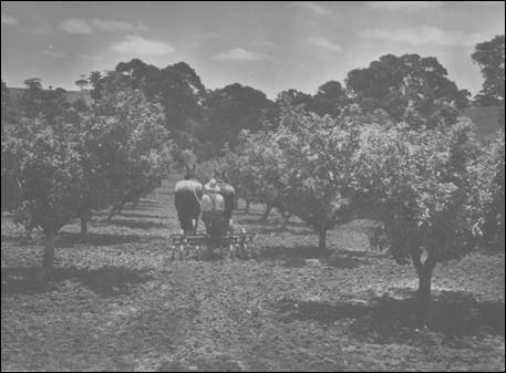
In 1908, the land which is now the park, was purchased by George Quinn, Chief Horticultural Instructor with the then newly formed Department of Agriculture for £88 , for the purpose of establishing an experimental orchard to trial and experiment with a wide range of fruit trees.
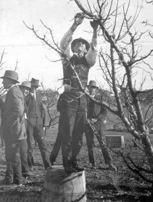
Above:- George Quinn demonstrating pruning techniques in 1918. Courtesy of http://www.pir.sa.gov.au
Over 4,000 varieties of fruit trees were counted in a census in 1927. The orchard was considered to be the largest collection of fruit varieties in one plantation anywhere in the world. However, in the late 1930s, problems with soil erosion and fertility led to the orchard being mainly replanted with varieties more suited to the local climate. Orcharding in the area declined in the 1960s and resources were progressively transferred to a new facility at Lenswood. In 1968 the Blackwood orchard ceased.
The former manager’s house dating back to c. 1909 can still be found in the western section of the park.


In 1985 and 1993, South Australian State government plans to rezone and sell off the land, resulted in community protest meetings and petitions demanding that the land be retained in perpetuity as public open space. In 1993 the Save the Blackwood Forest Committee was formed and maintained consistent pressure on a succession of ministers over the following years. There were a number of protest rallies and marches, public meetings, community tree plantings and tent embassies on the land. In 2001, after a long and difficult struggle, the Blackwood Forest Reserve was declared permanent open space as part of the Greater Mount Lofty Parklands.
There is an active Friends of Blackwood Forest Recreation Park. Their website can be located at…..
http://www.communitywebs.org/friendsofblackwoodforest/history.php
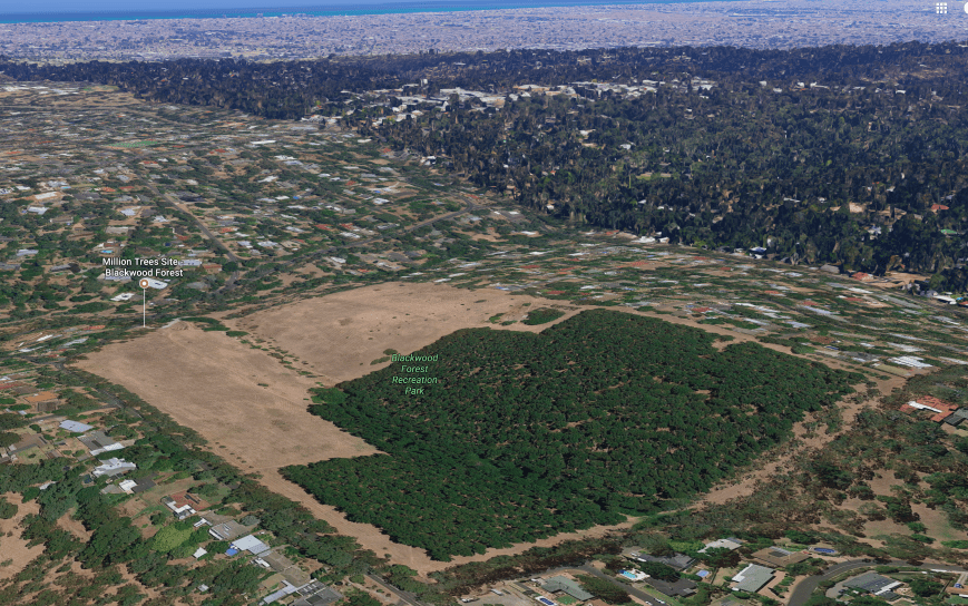
Above:- Aerial shot showing the park, with Adelaide in the background. Image courtesy of Google maps
Over 40 species of birds have been recorded in the park including Maned Duck, Adelaide Rosella, Eastern Rosella, Rainbow Lorikeet, New Holland Honeyeater, Spotted Pardalote, Eastern Spinebill, and Laughing Kookaburra.
Various native wildlife can be located in the park including koalas, Echidnas, Common Brushtail Possum, and Common Ringtail possum. During my activation I had a koala in the gum tree above me, enjoying the afternoon sun.
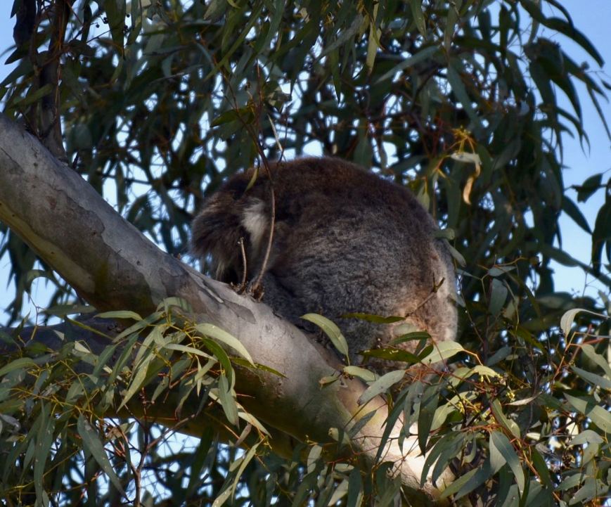
Above:- Koala having an afternoon sleep in the gum tree above my operating spot.
My initial operating spot in the park was alongside of the pines, at the northern end of Myrtle Road. Sadly after setting up and switching on the transceiver I found that there was S9 plus noise. It was impossible to operate from this position, so I pack up and headed off to find a quieter location.
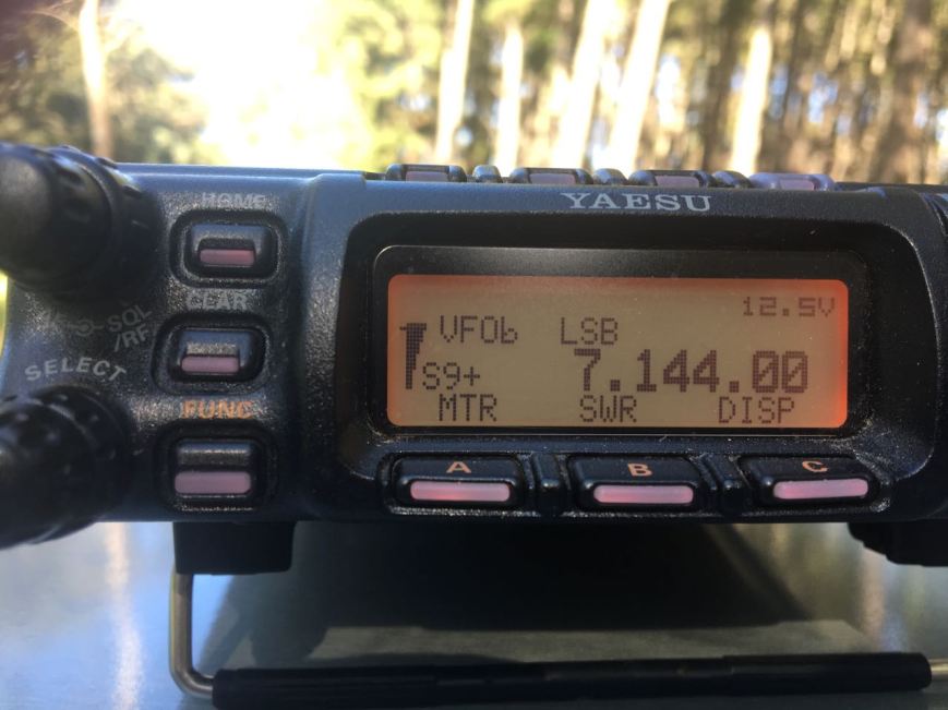
Above:- S9 plus noise at my first spot in the park. Unworkable!!!!
I then travelled along Turners Avenue and parked in the carpark near the junction with Main Road. I set up about 50 metres inside the park boundary in a nice cleared area. As it was a warm sunny day, I set up the fold up table and deck chair under the shade of some nearby trees.
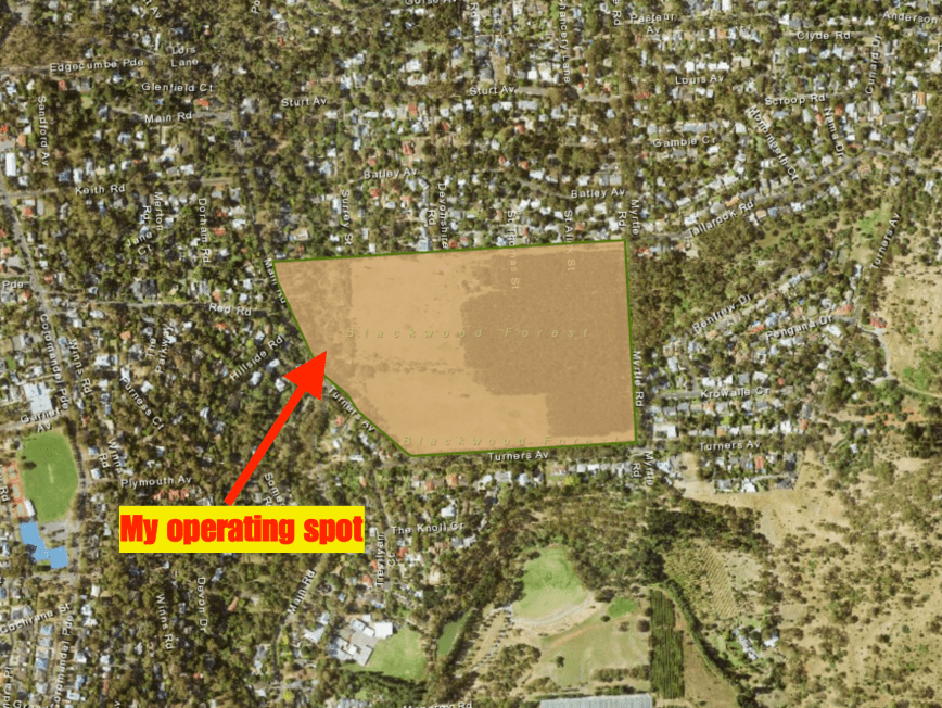
Above:- Aerial shot of the park, showing my operating spot in the western section of the park. Image courtesy of Location SA Map Viewer.
Prior to calling CQ I tuned across the 40m band and found Gerard VK2JNG/p on 7.135. Gerard was in the Cooleburba State Conservation Area VKFF-1307. It was a nice way to start the activation with a Park to Park contact. I then found Mark VK4SMA/p on 7.144, in the Denmark Hill Conservation Park. Mark was quite low down, as I was to he, but as we both had zero man made noise, we were able to work each other comfortably.
I then headed to 7.130 and called CQ. But not before sending my wife Marija VK5FMAZ a text message to let her know I was on 7.130. Marija was at home patiently waiting for me to come up, before heading off to do the shopping. I was pleased to be able to hear Marija back at Mount Barker on the other side of the hills, as close in propagation on 40m has been challenging to say the least, over the past few months. Scott VK7NWT then called in with a nice 5/9 signal, followed by Peter Vk3PF, Don VK3MCK, and then Dennis VK2HHA.
Contact number 10, qualifying the park for me for the VKFF program, was Garry VK3VLA at Geelong. I continued to work a steady flow of callers, with contact number 44 being reached whilst 1 hour & 15 minutes into the activation. Lee VK2LEE was my 44th contact, qualifying the park for me for the global WWFF program.


With 44 contacts in the log I headed over to 3.610 on the 80m band, where I logged Geoff VK3SQ in Beechworth, Mike VK5FMWW in the southern suburbs of Adelaide, and finally John VK5BJE in the Adelaide Hills. It was quite noisy on the 80m band from the park, with a noise floor of around strength 7.
I then tried my luck on 20m, but 5 minutes of CQ calls went unanswered, so I headed back to the 40m band. My first contact on returning there, was another Park to Park, with Mark VK4SMA who was now in the Ipswich Pteropus Conservation Park VKFF-1562. I then returned to 7.130 and called CQ and logged 5 stations, all from Victoria, before going QRT.
I had a total of 53 QSOs in the log and a new park activated for the World Wide Flora Fauna program.
I worked the following stations on 40m SSB:-
I worked the following stations on 80m SSB:-
References.
Birds SA, 2017, <http://www.birdssa.asn.au/location/blackwood-forest-recreation-park/>, viewed 23rd July 2017
Department for Environment and Heritage, 2005, Management Plan Blackwood Forest Recreation Park.
Friends of Blackwood Forest Recreation Park, 2017, <http://www.communitywebs.org/friendsofblackwoodforest/>, viewed 23rd July 2017
National Parks South Australia, 2017, <https://www.environment.sa.gov.au/parks/Find_a_Park/Browse_by_region/Adelaide_Hills/blackwood-forest-recreation-park>, viewed 22nd July 2017
After activating the Finniss Conservation Park I headed to the Totness Recreation Park VKFF-1754, just 2.5 km from home. I intended to take part in the 2017 Trans Taman Low Band Contest. The aim of the contest is to encourage Low Band activity Trans-Tasman, that is between VK and ZL.
Map showing the location of the Totness Recreation Park. Map courtesy of Location SA Map Viewer
I was all set up and ready to go by the commencement time of 0800 UTC, which is 5.30 p.m. South Australian local time. I ran my normal portable station for the contest: Yaesu FT-857d, 40 watts, and the 80/40/20m linked dipole, inverted vee, on the 7m heavy duty telescopic squid pole.


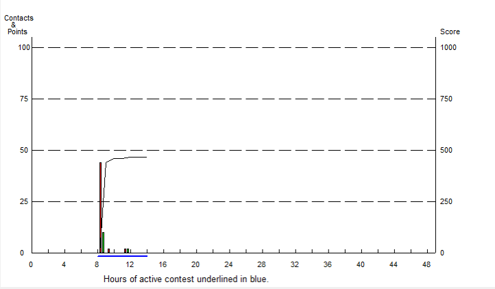
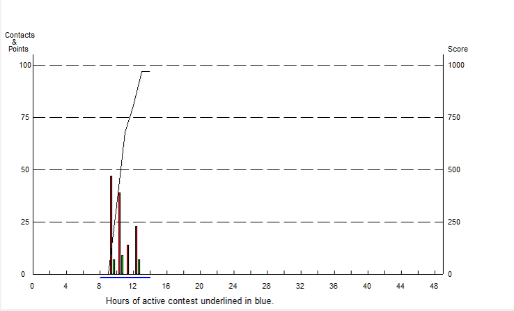
The contest is divided into three 2 hour periods. I remained out in the field until just after the commencement of the third period which was at 1200 UTC (9.30 p.m. local time). The cold weather got the better of me (got down to 4 deg C) and I packed up and headed home with a total of 171 contacts in the log. My claimed score was 2,347 points.
I made a total of 48 QSOs on the 40m band. New Zealand stations worked on 40m were:- ZL1YE, ZL3VZ, ZL1PC, ZL2ATH/p, ZL2BH, and ZL1JV.
I made a total of 123 QSOs on the 80m band. New Zealand stations worked on 40m were:- ZL3VZ, ZL1PC, ZL2BH, ZL1JV, and ZL1XS.
I enjoyed myself in the Trans Tasman, but there were long periods of calling CQ contest with no takers.
I started a couple of days off yesterday (Saturday 15th July 2017) after a few afternoon shifts at work, and with a few days of wet weather coming, I decided to head out to activate the Finniss Conservation Park 5CP-068 & VKFF-1030. The park is located about 70 km (by road) from Adelaide, and about 43 km south of my home.
Above:- Map showing the location of the Finniss Conservation Park. Map courtesy of Location SA Map Viewer.
The Finniss Conservation Park is 123 hectares in size and was first proclaimed on 29th January 1976. An additional 56 hectares was added between 1985 and 2005. The park is undulating with Woodland consisting of Pink Gum and Golden Wattle, and Low woodland consisting of Cup Gum and Pink Gum over Tate’s Grass-tree.
Above:- Aerial shot of the park with my home QTH in the background. Image courtesy of Google Maps.
The park is located just 7 km (by road) to the north east of the settlement of Nangkita, Interestingly it is located about 20 km to the north west of the settlement of Finniss which was originally known as Queen’s Own Town, after the Queen’s Own Regiment of Foot. The name of the town was changed in 1940 to Finniss, in in honour of an early surveyor and the first Premier of South Australia, Colonel Boyle Travers Finniss.
Above:- Colonel Boyle Travers Finniss. Courtesy of wikipedia.
Over 62 species of native bird have been recored in the park including Laughing Kookaburra, Galah, Adelaide Rosella, Superb Fairywren, New Holland Honeyeater, Grey Fantail, Eastern Spinebill, and Australian Golden Whistler.
The park is located in close proximity to a number of other conservation parks, including Cox Scrub, Mount Magnificent, Kyeema, and Bullock Hill.
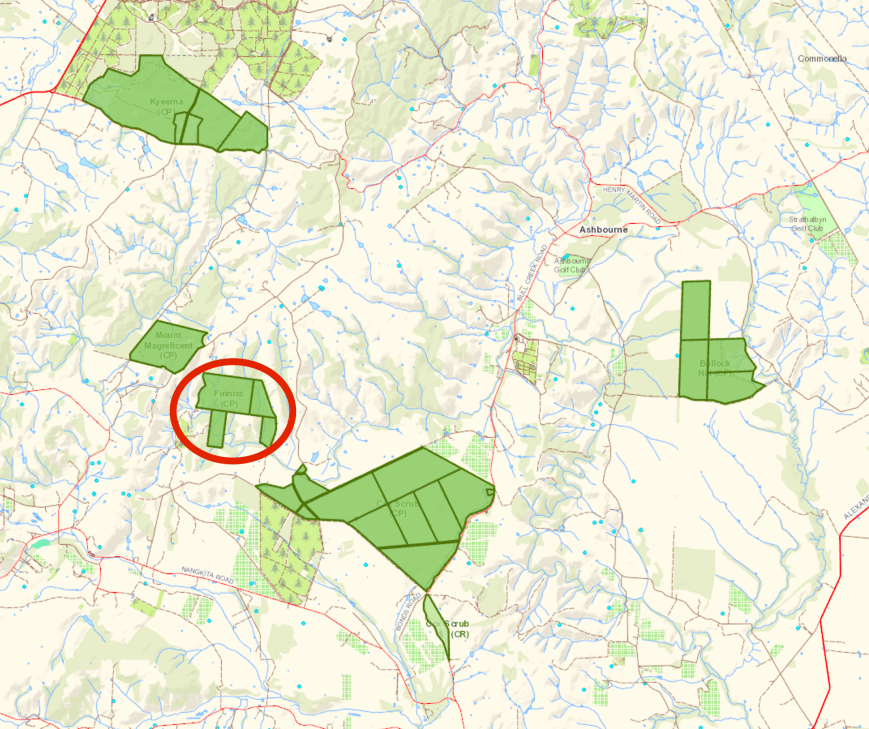
Above:- Map showing the location of the park, in close proximity to numerous other conservation parks. Map courtesy of Location SA Map Viewer.
I have activated the park once before, back in 2013, but this was prior to the park being added to the WWFF Directory. My previous activation of the park was for the VK5 National & Conservation Parks Award. For more information on my previous visit to the park, please check out my previous post at…..
https://vk5pas.org/2013/07/26/finniss-conservation-park/
Last time I activated the park I parked on Mount Magnificent Road and walked in to the park along the Heysen Trail from the northern side. But this time I decided to have a look at accessing the park from the southern side. I wasn’t sure whether I would be able to get in that way, but thought it was worth investigating.
I travelled along Bull Creek Road out of Ashbourne, passing the Cox Scrub Conservation Park. I turned right onto the Nangkita Road and through the little settlement of Nangkita. In the local aboriginal language Nagkita means ‘place of little frogs’.
Typical countryside in the Nangkita district
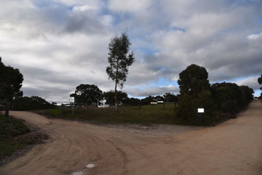
I then turned right onto Stones Ford Road. I soon reached the intersection with Ridge Road. I veered to the left and continued along Stones Ford Road.
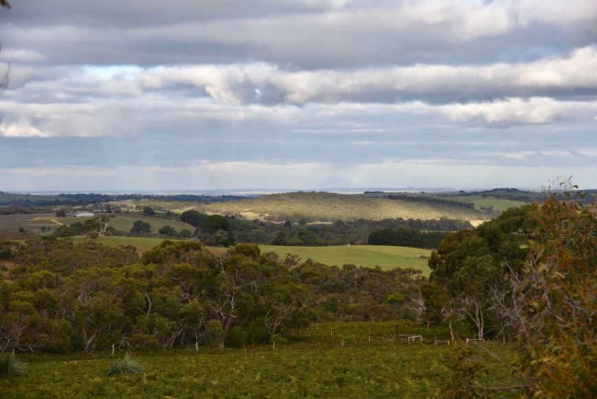
This is beautiful country with rolling green hills at this time of the year. I continued on, passing over the creek crossing on Stones Ford Road.


Much to my surprise, the road took me all the way to the park boundary.
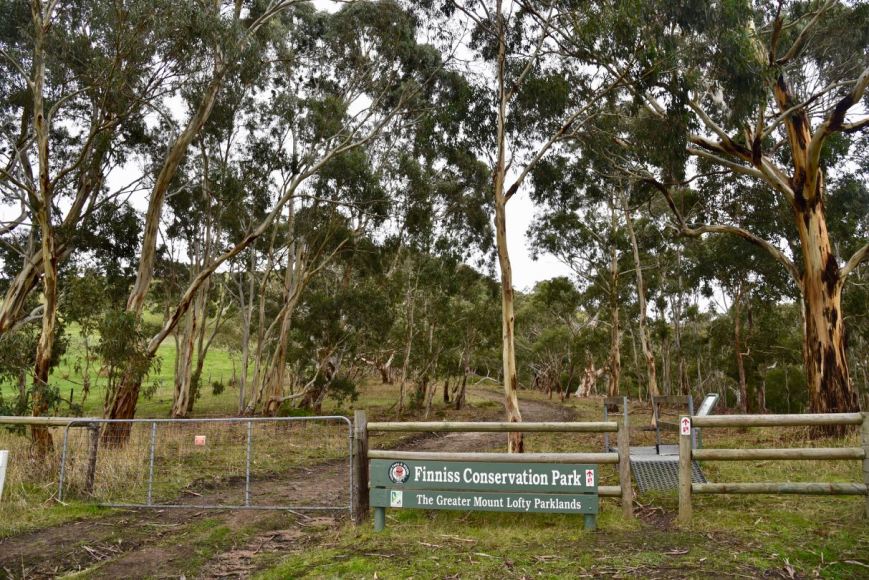
Above:- The southern boundary of the park.
I parked the vehicle and then commenced to set up my station, about 10-15m inside the park boundary. I ran the Yaesu FT-857d set at 40 watts, and the 80/40/20m linked dipole for this activation. There was no sun on this occasion, so the solar panels remained in the vehicle.
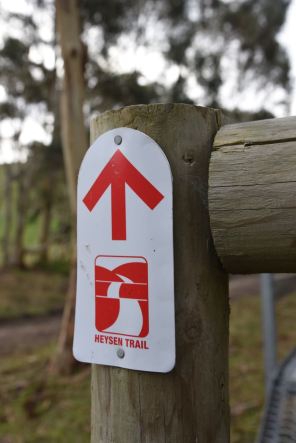
My operating spot was right alongside the Heysen Trail, a walking trail which is about 1,200 km long.
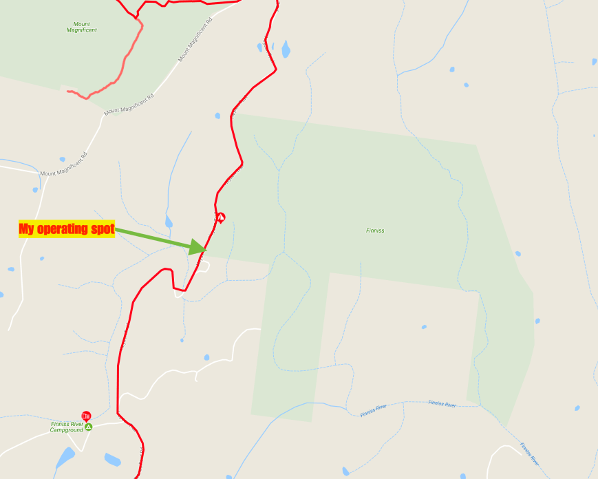
Above:- My operating spot. The Heysen Trail is marked in red. Map courtesy of heysentrail.asn.au
Prior to calling CQ I logged Gerard VK2JNG who was activating the Marrangaroo National Park VKFF-0598. There was a significant amount of QSB (fading) on Gerard’s signal, but as we both had low/non existant man made noise at our locations, we were able to comfortably log each other.
I then headed down to 7.139 and asked if the frequency was in use, with Peter VK3PF responding that it was all clear. After working Peter I logged Nik VK3NLK/p who was in the Tocumwal Regional Park VKFF-0978. It was nice to have another Park to Park contact in the log.
Conditions were quite poor on the 40m band with lots of QSB, probably due to the Coronal Mass Ejection from the sun the day previous. It took me 16 minutes to get contact number 10 in the log, qualifying the park for VKFF. Unfortunately there was no close in propagation, with my wife Marija VK5FMAZ sending me an SMS, advising that she had no copy back in Mount Barker.
With just 16 contacts in the log after 30 minutes, I decided to try my luck on the 80m band hoping that I would be able to log the VK5’s on that band. But 5 minutes of CQ calls went unanswered, and another SMS from Marija advising there was no copy on 80m. This was not looking good. But I perservered on 80m and out of the blue I heard ‘VK5FMAZ’. It was Marija with a good 5/8 signal. The band had changed. Next up was Les VK5KLV up at Port Augusta in the north of the State. But sadly, they were my only 2 callers on 80m.
So it was back to 40m where the number of callers had picked up. I soon had 34 stations in the log which is always a good sign for me. I run a paper log out in the field, which has 34 lines on each page. So once I am on page 2 I always know I am on the downward slide to the 44 QSOs required for the WWFF global award.
Nik VK3NLK called in again, this time in the Barmah National Park VKFF-0739. I now had 39 contacts in the log and saw a spot on parksnpeaks for John VK1/VA7JBE. So I headed down to 7.090 and logged John was on Black Mountain VK1/ AC-042 which is located in VKFF-0835.


I then headed back to 7.139 and called CQ again. Contact number 44 was soon in the log, a QSO with Kerry VK4LKB. I logged a further 16 stations, and with 60 contacts in the log, I headed over to 14.310 on the 20m band. I self spotted on parksnpeaks and called CQ, and much to my surprise my first caller was Gerard F1BLL in France. This was followed by Hans VK6XN who had a strong 5/8 signal. But my excitement was shortlived, as I had no further callers.
I took the opportunity of stretching my legs and taking a few photographs. When I returned to the radio, I head stations working John VK1/VA7JBE on the frequency. Unfortunately was unable to hear John. I then moved down to 14.305 and called CQ which was answered by Guenter DL5WW in Germany. I logged a further 15 stations including a little more DX from Europe.
With 78 contacts in the log, and a unique park for me as an activator achieved, I packed up and headed home. Thanks to everyone who called and thanks to those who took the time ti spot me.
I worked the following stations on 40m SSB:-
I worked the following stations on 80m SSB:-
I worked the following stations on 20m SSB:-
References.
Birds SA, 2017, <http://www.birdssa.asn.au/location/finniss-conservation-park/>, viewed 16th July 2017
Wikipedia, 2017, <https://en.wikipedia.org/wiki/Finniss,_South_Australia>, viewed 16th July 2017
Amateur Radio, Short Wave Listening, travel and history
Amateur radio experiences with VK1DA
Brisbane - Australia
german amateur radio station
Summits On The Air
SOTA on the peaks, wilderness QRP and some bushwalking
A fine WordPress.com site
Amateur Radio Adventures
Summits on the Ai
Amateur radio station from Belgium
Radio craft, homebrew, QRP/SOTA, AM
Ego loqui ad viros super montes
My adventures with Amateur Radio and Geocaching!
The rantings of VK2GAZ on his SOTA experiences in Australia
A survivor, with minor cuts and abrasions.
The Art and Craft of Blogging
The latest news on WordPress.com and the WordPress community.
Blog of Justin Giles-Clark VK7TW's SOTA and amateur radio adventures.
Occasional SOTA & Microwave operation
