After my recent trip to the Mid North of South Australia, I had managed to slide passed the 500 point mark for my Summit to Summit (S2S) contacts for the Summits on the Air (SOTA) program. I was fortunate enough to have a number of S2S contacts whilst I was away, including a number of DX S2S QSOs. So when I returned home, I applied for the 500 point S2S certificate, which arrived via email yesterday. Thanks to the SOTA organisers, and all of the SOTA activators who allowed me to reach this stage.
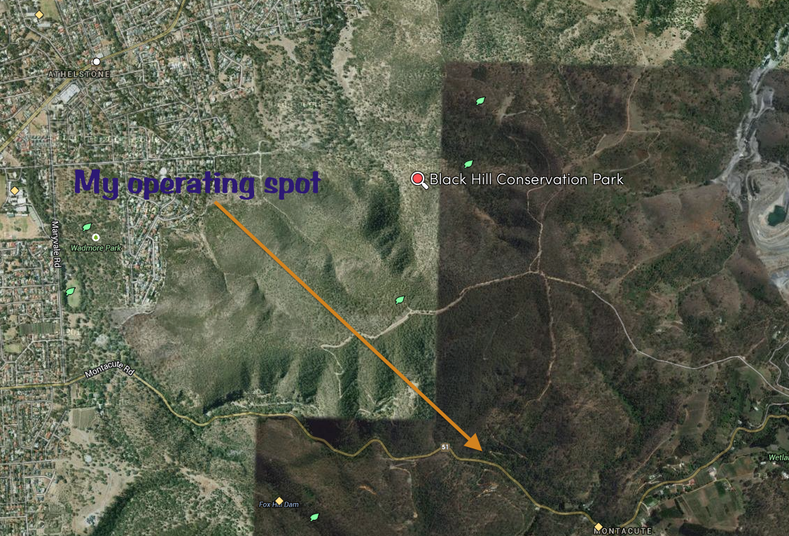
After activating the Montacute Conservation Park, I headed to the Black Hill Conservation Park (CP). It was just a short drive away, as the parks border each other, along Montacute Road. I travelled out of Moores Road and left onto Montacute Road and continued west on Montacute Road, through the gorge which separates the two parks.
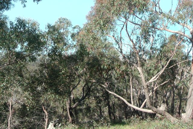
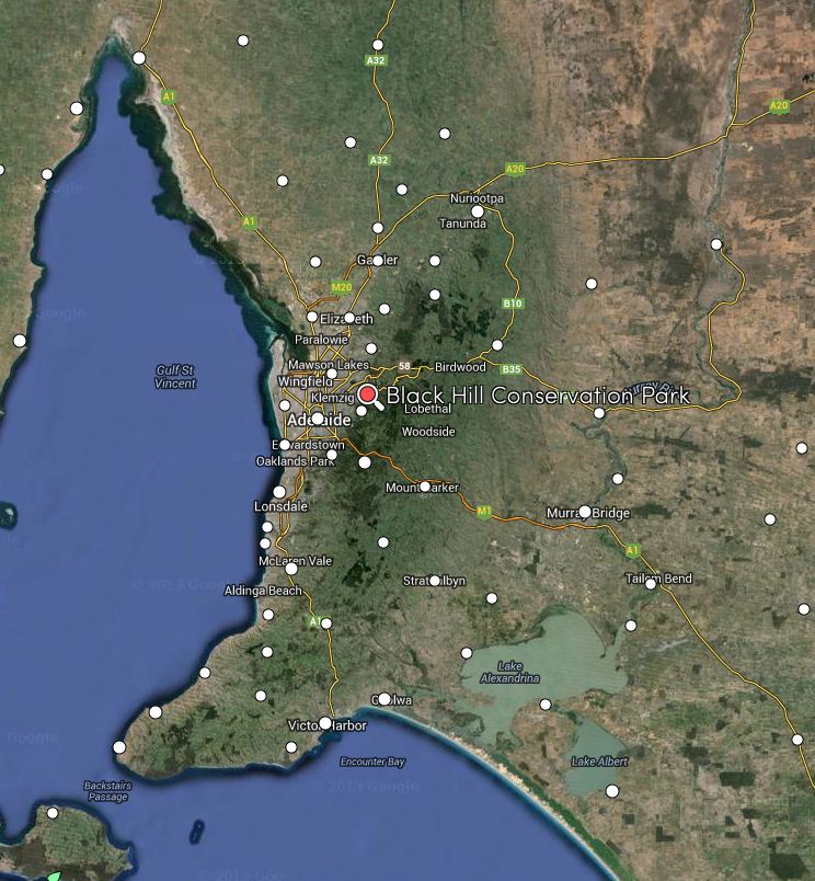
Black Hill CP is located about 10 km north east of Adelaide. The park covers an area of 684 hectares and features the low sheoaks which give Black Hill its name. The foliage of the sheoaks gradually matures to a dark rusty, almost black colour, as summer progresses. As you look from the Adelaide Plains, the hills appear to be black in colour. For more information on the park, please have a look at my previous post…..
I set up in a small carpark on the northern side of Montacute Road, near the eastern boundary of the park. It was a quite location, and was situated at the base of the Orchard Track, which leads up into the hills. There was a small creek flowing nearby and large hill faces on both my northern and southern sides.
My first contact was with Brian VK5FMID in Mount Gambier, and this was followed by Norm VK5GI in Willunga. I was then called by Tony VK5FTVR and then Darren VK5DT. My fifth caller was Mark VK5QI who was portable in the Morialta Conservation Park. As you would expect, Mark was very strong, being just a short distance away. After working Greg VK5GJ on his home brew QRP rig, I was called by Chris VK4FR5 who was portable in the Swan Reach Conservation Park.
I was also called by Bob VK5FO, who was on Mount Gawler, VK5/ SE-013, participating in the Summits on the Air (SOTA) program.
This slideshow requires JavaScript.
My second to last contact on 40m was with George VK6FADD. It was a real struggle to pull George through, due to the very severe static crashes. But we did make it. After working my final contact on 40m, Nigel VK5NIG, I lowered the squid pole and removed the links in my dipole, and then tuned around the 20m band. However, there was very little activity, other than some stations calling CQ Contest. I’m not sure which contest was on? My only contact on 20m was with Juan EA5CTE.
After operating for a little over an hour in the park, I had 29 QSOs in the log. Of those, 28 were on 40m SSB and just 1 on 20m SSB. Contacts were into VK1, VK2, VK3, VK5, VK6, & VK7 on 40m, and Spain on 20m.
The following stations were worked on 40m SSB:-
Brian VK5FMID; Norm VK5GI; Tony VK5FTVR; Darren VK5DT; Mark VK5QI/p (Morialta CP); Greg VK5GJ; Chris VK4FR/5 (Swan Reach CP); Peter VK3TKK; Ian VK5CZ; Amanda VK3FQSO; Peter VK5KPR; Ian VK3VIN; David VK5NQP; Jim VK2LC/m; Phil VK3BHR; Ian VK3AXF; Ian VK5KKT; Hauke VK1HW; Greg VK7FGGT; Damien VK5FDEC; Chris VK4FR/5 mobile; Paul VK7CC; Ian VK6SKY/p; Bob VK5FO/p S(OTA; Ron VK3JP; Peter VK3ABN; VK6FADD; and Nigel VK5NIG.
The following station was worked on 20m SSB:-
Juan EA5CTE.
References.
Natural Resources Adelaide and Mount Lofty Ranges, 2014, ‘Morialta and Black Hill Conservation Parks‘
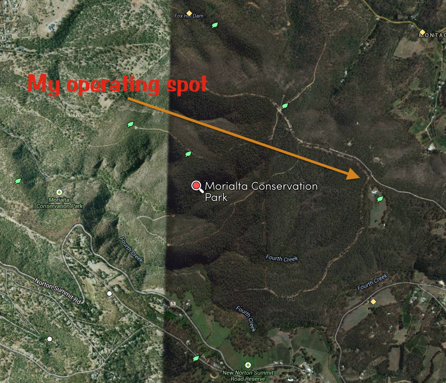
On Sunday afternoon, 12th October, 2014, I headed over to the Morialta Conservation Park (CP), which is about 30 km north west from my home (by road). This was to be the first time that I had activated the Morialta CP. On my way to the park I spoke with Mark VK5QI who advised that he was heading out with Gary VK5FGRY to activate some parks that afternoon and would meet up with me in the Morialta CP.
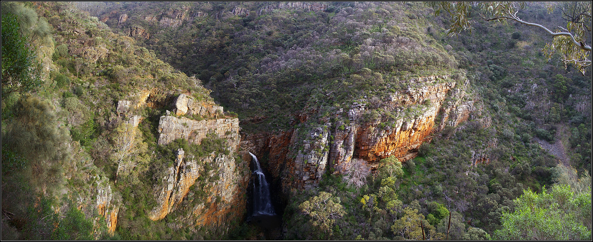
Morialta CP is located 10 km from Adelaide, in the Mount Lofty Ranges ‘Adelaide Hills’. The park which is 5.33 km² in size (533 ha), contains three seasonal waterfalls located alongside Fourth Creek which runs through the park. Morilata CP has an extensive network of walking trails and is also popular for rock climbing and abseiling. The park supports a wide variety of wildlife. The rock pools and creeks provide habitat for many small reptiles and frogs. Western Grey kangaroos, koalas, Southern Brown bandicoots, and echidnas call the park their home. Numerous birds can be found in the park including hornbills, wattlebirds, treecreepers, finches, lorikeets and several birds of prey. The threatened species, the Chestnut-rumped Heathwren can be found in the park.
Morialta derives its name from the local aboriginal Kaurna language meaning “ever flowing” or “running water”. The area which is now Morialta Conservation Park was originally acquired by pastoralists in 1839. In 1847, John Baker bought the land and built the grand Morialta House and Morialta Barns on Fourth Creek, near the head of the gorge. John Smith Reid was also a major landholder in the area, and in 1911, he offered to donate part of his land as a national reserve.
Reid donated 218 hectares (540 acres) in 1913, and in 1915 the area was declared a National Pleasure Resort. Much of the construction work in the park was begun in the 1920s and 1930s, although floods and bushfires have destroyed much of this original work. In 1966 additional property to the east was added, and the park was declared a National park. In 1972 the park was re-proclaimed as Morialta Conservation Park.
Above picture is courtesy of wikipedia.org
Click on the link below to view a historic video on the Morialta Conservation Park…..
I drove up Moores Road, which runs off Marble Hill Road, and continued west until I reached the north eastern corner of the park on the southern side of Moores Road. There is a carpark here on the northern side of Moores Road. Moores Road is a dirt road, but is easily passed by 2WD vehicle. I set up on Third Falls Track, just inside the park boundary.
I used my Yaesu FT-450 and the 20m/40m linked dipole for this activation, and ran 40 watts. After making myself comfortable on my deck chair, at the fold up table, I tuned around the 40m band and found Mark VK5QI who was portable in the Horsnell Gully Conservation Park, operating on 7.105. That was a nice start, to get a park to park contact. I then tuned down to 7.100 and spoke with Chris VK4FR/5 for another park to park contact. Chris was operating from the Morgan Conservation Park in the Riverland region of South Australia.
I then went down to 7.085 and first station worked there was Steve Vk5SFA, followed by John Vk5FTCT, and Greg VK5GJ operating QRP again (5 watts) with his home brew transceiver. A nice signal as always Greg. Seven contacts later I was called by Damien VK5FDEC who was portable in the Port Gawler Conservation Park, operating with Steve VK5AIM. It was great to see so many activators out and about in the parks, enjoying the sunshine.
I continued to work a steady flow of callers from VK2, VK3 & VK5, and was then called by Mark again, VK5QI, who this time, was operating portable from the Giles Conservation Park. This made four park to park contacts for this activation. Many thanks to the other park activators.
This slideshow requires JavaScript.
After working a total of 23 stations on 40m SSB, I lowered the squid pole and removed the links in the dipole, and then out our a few CQ calls on 20m. First taker there was Greg VK5LG, followed by Adam VK2YK, and then Mike VK6MB. It was a little too early for any DX on 20m. In fact the band was very quiet, with some very low down signals from eastern Europe. Thanks to Col VK5HCF for spotting me on parksnpeaks.
The goat bleated on my SOTA Goat app on the iPhone, alerting me to Peter VK3PF, being on 7.090. So the squid pole was lowered again, and the crocodile clips attached, allowing me to operate on the 40m band. I quickly tuned the VFO to 7.105 and worked Peter who was on Sams Hill, VK3/ VG-049, for the Summits on the Air (SOTA) program.
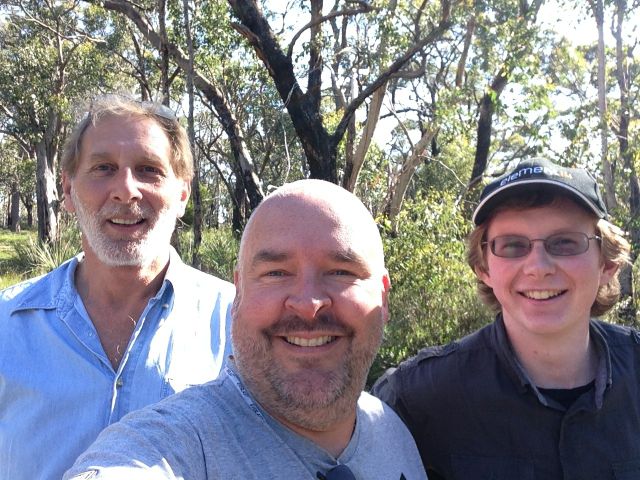
After an hour in the park, Mark VK5QI and Gary VK5FGRY arrived. After a chat and a quick inspection of each others gear, they set up their station and started calling CQ. I was the first in their log, whilst in was mobile along Moores Road, on my way to my next activation at the Black Hill Conservation Park.
The following stations were worked on 40m SSB:-
Mark VK5QI/p (Horsnell Gully CP); Chris VK4FR/5 (Morgan CP); Steve VK5SFA; John VK5FTCT; Greg VK5GJ; Larry VK5LY; Arno VK5ZAR; David VK5NQP; Tony VK5FTVR; Stu VK5STU; Col VK5HCF; Damien VK5FDEC/p (Port Gawler CP); Brian VK5FMID; Bob VK5FO; Bon VK5FPAC; Paul VK3FALC; Amanda VK3FQSO; Ian VK3VIN; Nick VK3ANL; Joe VK3YSP/m; John VK2AWJ; Peter VK3TKK; Mark VK5QI/p (Giles CP); and Peter VK3PF/p (SOTA).
The following stations were worked on 20m SSB:-
Greg VK5LG; Adam VK2YK; & Mike VK6MB.
References.
Natural Resources Adelaide and Mount Lofty Ranges, 2014, ‘Morialta and Black Hill Conservation Parks‘
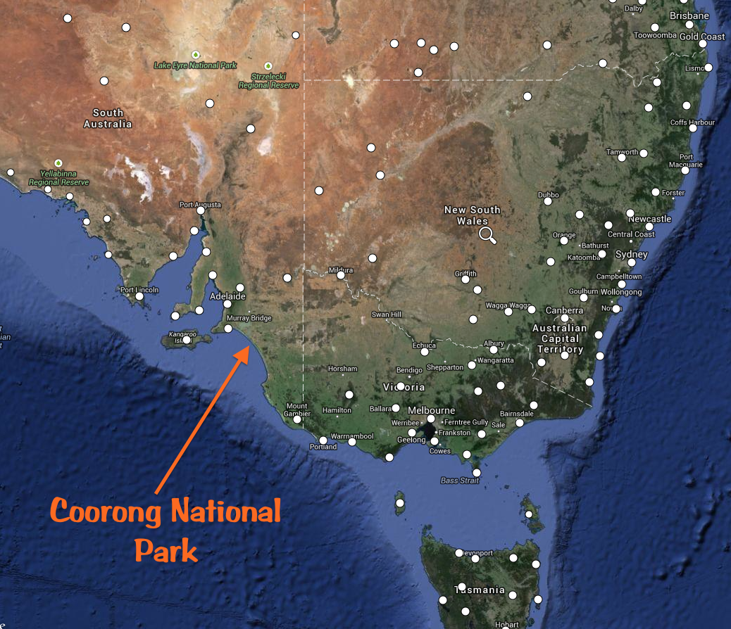
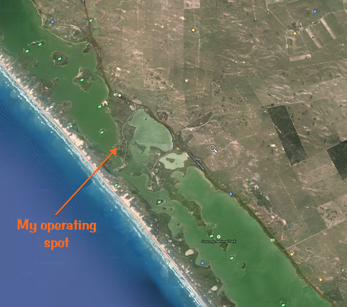
On Saturday 11th October, 2014, I headed to the Coorong National Park (NP), which is located in the South East of South Australia. The Coorong NP qualifies for both the World Wide Flora Fauna (WWFF) program, and the VK5 National and Conservation Parks award. I had activated the Coorong NP previously, but I was hoping to achieve a few more QSOs to get me over the required 44 QSO requirement for the global WWFF awards.
I left home and travelled a total distance of about 150 km to reach my operating spot, which was at Parnka Point in The Coorong NP. I travelled east along the South Eastern Freeway, passed Murray Bridge and into the town of Tailem Bend which runs alongside the mighty River Murray. From there I travelled south along the Princes Highway and on to the picturesque town of Meningie, which is located on the shores of Lake Albert. I continued south east out of Meningie along the Princes Highway and then turned right into Parnka Point Road. I then travelled the 3 km down the Prank Point Road, to the narrowest point of the Coorong NP. The area is referred to as ‘Hells Gate’.
I set up on the western side of the small peninsula which runs down to the stretch of saltwater which flows between the mainland and the sand dunes called the Younghusband Peninsula. I found a shelter with a nice wooden table and benches, which got me out of the warm afternoon sun. The spot had a lovely view out to the west, across the water towards Bluff Island, Rabbit Island, and Snake Island. I could hear the breaking waves of the Southern Ocean in the background.
For this activation I ran the Yaesu FT-450 and the Bandhopper 20m/40m linked dipole, which I supported on a 7 metre squid pole. I placed the squid pole into the aluminium squid pole holder and drove this into the sandy soil, and held it in place with an octopus strap. For 40m I used 40 watts, and when I QSYd a little later to 20m, I ran 80 watts. I powered the radio with my 44 amp hour power pack.
I started off on 40m SSB on 7.095 and called CQ and was immediately called by Larry VK5LY. This was followed by Peter VK3TKK, and then Tony VK5FTVR, and then Les VK5KLD. A steady flow of callers followed from VK2, VK3, and VK5. When things slowed down a little on 40m, I tuned around the band and found Allen VK3HRA who was portable on Mount Matlock, VK3/ VC-001, for the Summits on the Air (SOTA) program. I then found Chris VK4FR/5 who had arrived in the Maize Island Conservation Park and secured a ‘park to park’ contact with Chris. I then went back to 7.0985 and put out a CQ call and was called by Craig VK3CRG and then John VK2AWJ, and then Kevin VK3NKC. After a number of other CQ calls, there were no takers, so again I tuned around the band and this time I found Nick VK3ANL who was portable on Gentle Annie, VK3/ VT-078.
This slideshow requires JavaScript.
It was pleasing to see a few VK’s calling me, using just QRP. They included Peter Vk3TKK, Col VK5HCF, and Greg VK5GJ using his home brew transceiver. It was very quiet in the park, so I was able to copy them extremely well.
After working a total of 27 stations on 40m SSB, I QSYd to 14.244 and called CQ and was almost immediately called by Sergey RA3PCI in Russia. Much to my surprise, this was followed by a call from Dirceu, PY5DK with a beautiful 5/9 signal from Brazil. This was my first every contact with Brazil whilst operating portable, and his call took me by surprise. This was followed by Vladimir EU2MM in Belarus, and then Albert S58AL in Slovenia. A constant flow of callers from Europe followed with very good signals coming in on the long path. This was until the DXpedition, XR2T decided to start operating just below me, operating split, with the call frequency just 1 kc above me. So, after working on the frequency for one hour, that was the end of that.
However, out of everything bad, comes something good. It gave me an opportunity to tune up to 14.280 where I made contact with regular SOTA activator, Mike, 2E0YYY and Dave G4ASA, who were on Normanby Top, G/ TW-005.
I then found another clear frequency on 14.197 and again called CQ, and this was soon responded to by DK4RM in Germany, S51INT in Slovenia, and ON2VR in Belgium. I remained on this frequency, working into Europe, South America, Hawai, and Japan, until the battery went flat. I am sorry to all the stations that were still calling when the battery failed. I would have loved to have stayed and kept working the DX, but it was just not possible.
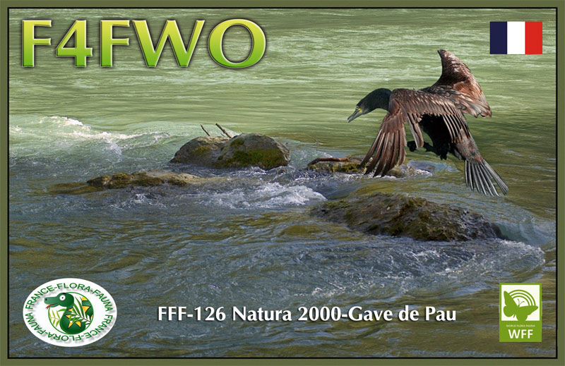
I was fortunate enough to work two other WWFF activators whilst in The Coorong. They were Sylvain, F4FWO in Gave de Pau, FFF-126, and DF7GC who was in Nature Park Black Forest South, DLFF-124.
I was also pleasantly surprised to be called by HC5AI in Ecuador, KH7CX/p in Hawaii, and 7N2TNI, and JA8RJE, both in Japan.
And it is always nice to get a few mates in the log. They included my good friends from Belgium: Marnix OP7M and Albert ON2WAC. I stayed with Marnix during my recent Europe trip, and also met with Albert.
Only a handful of VK’s called me on 20m. They were Mike VK6MB, Dave VK3VCE, Greg VK8GM, and VK2HJW.
Thanks to the Australian stations that placed me on the parksnpeaks site. And thanks to the following stations for placing me on the DX cluster, which kept the DX rolling in on 20m.
I received an email after this activation, advising me that Luciano I5FLN could hear me on 7.095. Luciano said: ‘By way way I heard you earlier on 7095 talking with several VK but could not compete with my sloper they were to you more strong than my signal of course.’ And it appears from the DX cluster, that Pit YO3JW could also hear me all the way over in Romania. Amazing. Sorry, I could not get them both in the log on 40m.
A total of 177 QSOs were made during this activation…..including my largest every haul of DX during a portable activation. This included a total of 27 contacts on 40m SSB into, and 150 contacts on 20m SSB into Europe, Japan, South America, and Hawaii. It certainly showed that WWFF is extremely popular in Europe, and the hungry WWFF park hunters in Europe are very keen to get an Australian National Park in their log. Now if only WWFF became popular in Australia.
The list of worked stations is extensive. But here is a breakdown of the countries that I worked:-
Australia
Austria
Belarus
Belgium
Brazil
Croatia
Czech Republic
Denmark
Ecuador
England
Finland
France
Germany
Hawaii
Hungary
Italy
Japan
Lithuania
Luxembourg
Netherlands
Northern ireland
Poland
Romania
Russia
Slovak Republic
Slovenia
Spain
Sweden
Switzerland
Ukraine
I have placed a short video on You Tube of this activation…..
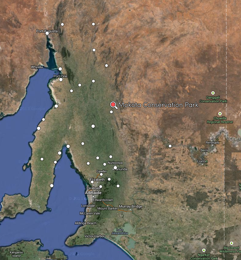
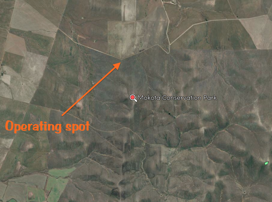
After packing up at the Hallett Hill summit, I headed back into Mount Bryan township, and then headed north for the Mokota Conservation Park (CP), which is located about 180 km north of Adelaide, and about 5 km north east of the little township of Mount Bryan.
Map courtesy of mapcarta.com
I drove out along White Hill Road, which is a dirt road, but easily passable with 2wd. White Hill Road runs off the western side of the Goyder Highway, just outside of Mount Bryan. As I drove out towards the park, I was surrounded by summits; Mount Bryan VK5/ SE-001 to my north; Hallett Hill VK5/ SE-004 to my west; and Mount Cone VK5/ SE-002 to my south. I had never been to Mokota CP before, and this was s spur of the moment activation, so I didn’t know what to expect. The land out here is quite barren, and as I headed east, the land was quite unmentionable. It was the last place I expected to find a conservation park.
map courtesy of mapcarta.com
I had travelled along White Hill Road for quite a few km, expecting to see a patch of scrub. But there was none to be seen. However, as I reached a bend in the road, out the corner of my right eye, I saw a few interpretive signs in what looked like a paddock. It was in fact the Mokota Conservation Park.
Mokota CP is about 455 hectares in size and was the first reserve in South Australia to be acquired with the priority aim of protecting a native grassland. The park, which was first proclaimed on 26th October, 2000, plays an important role in protecting native grassland and is one of the largest remaining examples of an open grassy vegetation community. It is one of the best examples of tussock grassland remaining in South Australia. There are a number of interpretive signs in the park which give an insight into the unusually high quality grassland, including 150 indigenous flora species surrounding it. A total of 32 of the species are of particular conservation significance to South Australia.
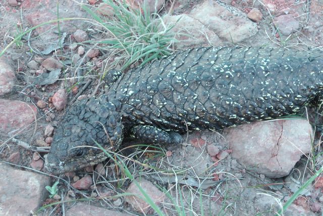
The park also provides habitat for about 28 native animal species, including Western Grey kangaroos, Red Kangaroos, and Euros. It was absolutely full of Western Grey kangaroos during my visit. They were everywhere….grazing in the grasslands, and drinking at the nearby dam. Quite rare really, because generally on a hot day, kangaroos are seeking shelter from the sun. But they were certainly out in large numbers whilst I visited the park. The rare white spotted skipper butterfly is of particular interest and is listed as vulnerable. The park also provides habitat for the Flinders worm lizard whose conservation status is listed as vulnerable at national and state levels.
This slideshow requires JavaScript.
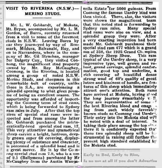
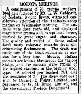
The park is in the area of the original Mackerode estate, founded by G.A. Gebhardt. Mokota is a Maori name, chosen by L.W. GEBHARDT, meaning ‘fine view’. Interesting that he chose a Maori name. Prior to European settlement, the land was occupied by the Ngadjuri aboriginal people. The area of the park had been grazed from about the 1860’s right up until 199, when the land was acquired by the South Australian Government. I found some interesting newspaper articles from the early 1900’s re L.W. GERBHARDT.
Above: from The Register, May 1935. Courtesy of trove.nla.gov.au
Above: from The Register, Sept 1919. Courtesy of trove.nla.gov.au
I used the Yaesu FT-817nd and ran just 5 watts for this activation, and my Band Hopper 40m/20m linked dipole. I used one of the interpretive signs to secure the 7 metre squid pole, with a few octopus straps, weighting down the ends of the dipole with some moss rocks.
I had sent out an SMS to the normal gang of park hunters prior to the activation, hoping that I would get a few calls. I’ve found the SMS group message works really well. Sadly at the moment, the VK5 Parks award does not have an audible alerting system like SOTA Goat or Rucksack radio. So activators rely on any method of getting the word out that they are in a park. Allen VK3HRA has developed parksnpeaks, but at this stage there is no audible app for mobile phones.
I started off on 7.105 on 40m and put out a CQ call and was greeted immediately by the normal crew: Col VK5HCF, Larry VK5LY, Brian VK5FMID, and John VK5BJE. Col was a good 5/8 signal with his normal QRP 5 watt signal. The other motley crew were all 5/9 or 5/9 plus. I was also called by John VK5DJ in Millicent, David VK5NQP, and Andrew VK2UH. It was quite a struggle with Andrew, as it was the middle of the day and the 40m band had gone to sleep. Andrew was a good 5/6 but he was only receiving me 4/3.
It was very slow going with not many contacts for this activation. I put out numerous CQ calls but didn’t get any respond, so I tuned around the band and managed to make contact with Andrew VK1NAM who was on SOTA peak, Baldy Range, VK2/ ST-008. Andrew was quite weak, 5/3, and I received a 5/1 signal report from Andrew. But that is the beauty of operating portable. The noise floor is generally very low and that was certainly the case in Mokota CP. You could hear a pin drop, and thus, able to work the weakest of weak stations.
I then lowered the squid pole, and removed the crocodile clips in the linked dipole for 20m, and then raised the squid pole back into position. I put a few calls out on 14.200 but didn’t receive any replies. I tuned across the band and found it was very quiet, with very few stations active. I did hear a few amateurs from the United States, but their signals were very low. Certainly too low to even attempt to give them a call.
It was starting to creep up into the mid 30 degrees, so I decided to pack up and head back home to Mount Barker in the Adelaide Hills. I had just 8 contacts in the log on 40m SSB. However, this was a very interesting park, and was certainly well worth a visit.
The following stations were worked:-
Col VK5HCF; Larry VK5LY; Brian VK5FMID; John VK5BJE; John VK5DJ; David VK5NQP; Andrew VK2UH; and Andrew VK1NAM/2 (SOTA)
References.
Cockburn, R, 2002, South Australia. What’s in a Name?, 4th edition, Adelaide
Government of South Australia, 2003, Mokotoa Conservation Park Management Plan.
Government of South Australia, ‘Parks of the Mid North‘.
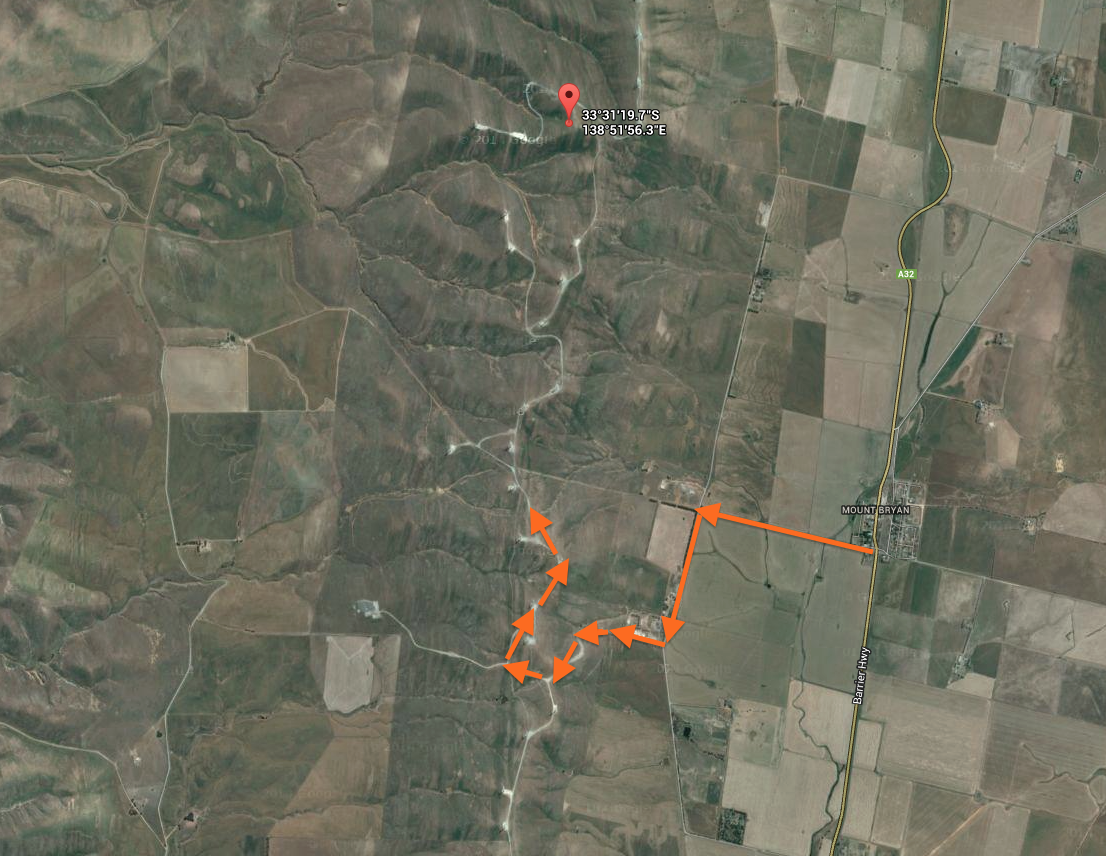
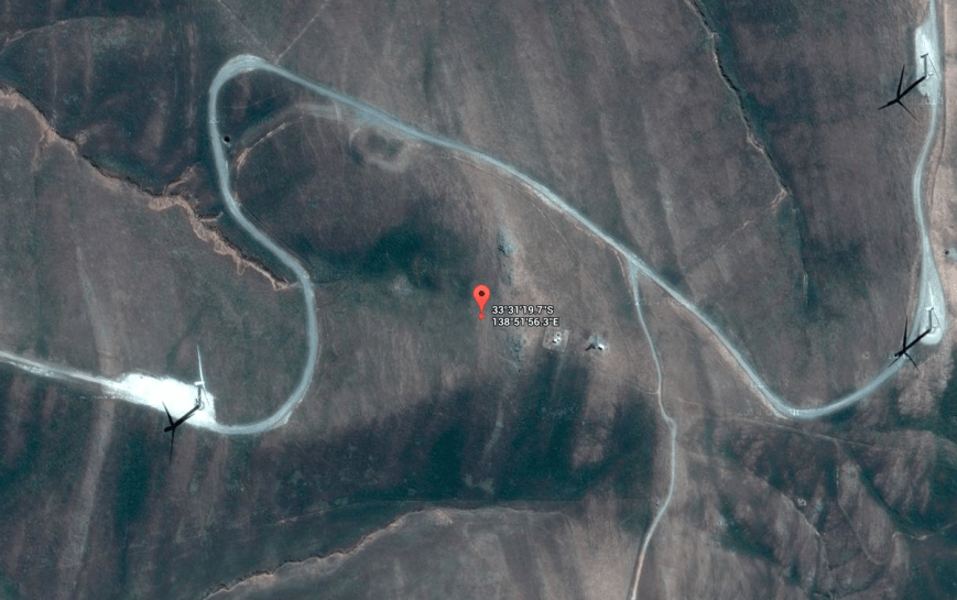
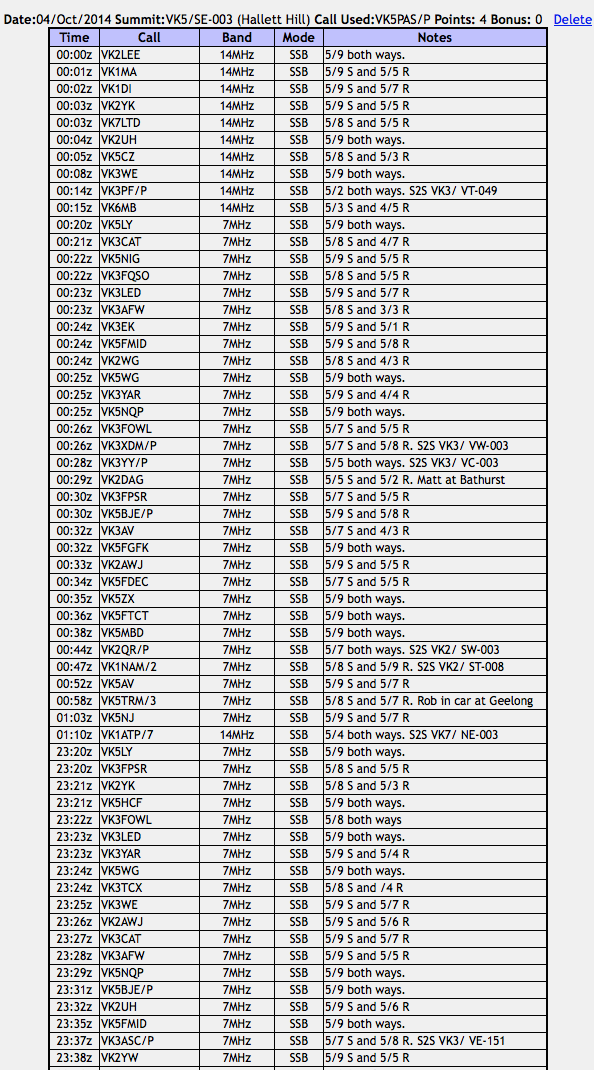
My one and only activation for Saturday 4th October, 2014, was Hallett Hill, VK5/ SE-003, which is located about 180 km north of Adelaide, and about 2 km north west of the little township of Mount Bryan, in the Mid North of South Australia.
Map courtesy of mapcarta.com
I got up early and after a hearty breakfast at the Commerical Hotel at Jamestown, I headed towards New Campbell Hill, VK5/ SE-007, which is situated on the edge of the Bundaleer Forest Reserve. However, much to my disappointment, there was a sign on the gate at Neindorf Road, stating that access was prohibited due to reforest operations. Bugger ! So I looked at possible alternatives and was lucky enough to make contact with the land owner of Hallett Hill. So south east I headed towards Mount Bryan.
Hallett Hill is an easy summit to access. It is located on private property, so please obtain permission from the land owner prior to entry. Details can be found on the SOTA site. I had activated this summit with Ian VK5CZ in July 2013, but it appears we entered the summit from the northern end via another land owner’s property. This time I travelled out along the Mokota Road, at the southern end of the Mount Bryan township. Upon reaching the T junction, turn left onto Collinsville Road. A few km up on your right you will reach a set of double gates with various signs on them including ‘High Voltage. Authorised personnel only. Keep out‘. This is where you access the summit. The dirt road will take you to the ridge line, where you need to travel north to the actual summit.
map courtesy of googlemaps.com
map courtesy of googlemaps.com
I used a wire fence and post to secure the 7 m squid pole, with some octopus straps. As this was the 2nd year anniversary of the Summits on the Air (SOTA) program) in South Australia, I had the SOTA flag flying proudly. And it was certainly flying! As expected, the wind was very strong on the top of the hill. After all, I was set up amongst a wind farm. Again, for this activation I ran the Yaesu FT-817nd and 5 watts and the linked dipole.
I propped on 7.090 on 40 m and called CQ and this was responded to immediately by Larry VK5LY with a very strong 5/9 plus signal from The Riverland. This was followed by SOTA stalwart, Peter VK3FPSR, Adam VK2YK, and then the ever reliable Col VK5HCF at Mount Gambier. A steady flow of callers from VK2, VK3, and VK5 followed. The band appeared to be very good, with excellent signals coming in from both locally and the eastern states. And I was receiving good signals back from as far afield as New South Wales, with my 5 watts.
Sadly, there was a large amount of noise on 40m, most likely generated by the wind turbines. It was about a strength 3 at times, and was a really annoying squealing sound. So any low signals were quite difficult to copy, if not impossible.
I managed two summit to summit contacts on 40m prior to the UTC rollover. That was with Mark VK3ASC who was portable on Mount Elliot, VK3/ VE-151. Mark had a good 5/7 signal, and he reciprocated with a 5/8 signal report for me. A few contacts later, I was called by Peter VK3PF who was portable on Mount Hooghly, VK3/ VT-049. Peter was very low down (5/2), but fortunately at the time he called, the noise being generated by the wind turbines was low and we were able to make the contact.
After working a total of 26 stations on 40m SSB, I QSYd to 14.310 on 20m SSB and started calling CQ. My first contact on 20m was with Mike VK6MB, who was a little weak (5/3). I received a 4/3 signal report from Mike in Perth. Not bad really, considering the distance is nearly 2,600 km. This was followed by Ian VK1DI, VK7LTD, Matt VK1MA, Ian VK5CZ and Lee VK2LEE. All had good strong signals. I remained on 20m for the UTC rollover and worked a further 10 stations. This included a summit to summit contact with Peter VK3PF on Mount Hooghly, VK3/ VT-049.
I then moved back to 40m to give the SOTA chasers on 40m a chance to pick up another 4 points. First taker there again was Larry VK5LY, followed by Tony VK3CAT and then Nigel VK5NIG. I went on to work a total of 31 stations on 40m SSB after the UTC rollover.
This included a few summit to summit contacts. The first being with Mitch VK3XDM who was portable on Mount Rosea, VK3/ VW-003. Mitch’s signal was a good solid 5/7 and I received a 5/8 report from Mitch. Immediately following this, Glen VK3YY called in from Mount Ritchie, VK3/ VC-003 (5/5 both ways). I then spoke with Rob VK2QR who was portable on Mount Jackson, VK2/ SW-003. As always, Rob had a good signal (5/7 both ways). My final summit to summit contact on 40m SSB was with Andrew VK1NAM/2 who was portable on Baldy Range, VK2/ ST-008. Andrew as an excellent 5/8 signal and I received a 5/9 signal report from Andrew.
I had been patiently waiting for Paul VK1ATP/7 who was on SOTA peak, VK7/ NE-003, to come up on 20m. I had heard him talking with Andrew VK1NAM on 40m, but sadly, due to the wind turbine noise, he was just too weak to work. Just before I was about to pack up, the SOTA Goat app bleated on my i-phone, and it was a spot for Paul on 14.310. I had already lowered the squid pole, and removed the crocodile clips in anticipation. Paul was a beautiful 5/4 signal coming in, and I was fortunate enough to make my first ever VK7 SOTA contact. And a summit to summit to boot. I was very happy.
This slideshow requires JavaScript.
After about 90 minutes on the hill, it was time to pack up and head off. I had a total of 73 contacts on 40m SSB and 20m SSB in the log.
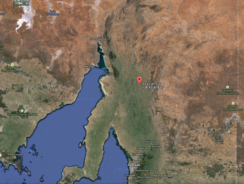
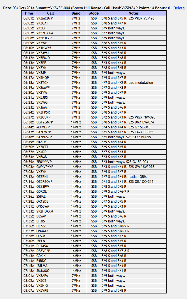
My last Summits on the Air ((SOTA) activation for Friday 3rd October, 2014, was Brownhill Range, VK5/ SE-004, which is located about 212 km north of Adelaide, and about 5 km south east of Jamestown, in the Mid North of South Australia. I last activated this summit in July 2013, so another 4 points as a SOTA activator were there for the taking.
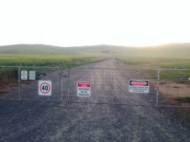
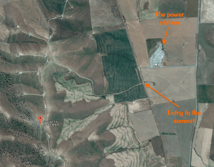
Access to the summit is via Seven Trees Road. Turn onto the Booborowie Road, from the Wilkins Highway (Jamestown to Hallet Road). Travel about 5 km south along the Booborowie Road and you will see The Willows Road, on your right. Travel west along The Willows Road until you reach the T junction with Seven Trees Road. Turn left onto Seven Trees Road. Diagonally opposite the power plant, you will see some double gates with various signs on the gates including ‘Unauthorised access. Tresspassers will be prosecuted‘. This is the access point to the summit. The summit is located on private property, so please obtain permission prior to access.
The Brownhill wind farm consists of 45 Suzlon S88 turbines each of a rated 2.1 megawatt (MW) for a total of around 95 MW. It is adjacent to an existing 180 MW gas fired peaking power plant. The wind farm construction was carried out by Suzlon Energy Australia Pty. Ltd. This site utilises an innovative rock anchor solution to support the turbines using only one third of the concrete and reinforcement required in traditional foundations.
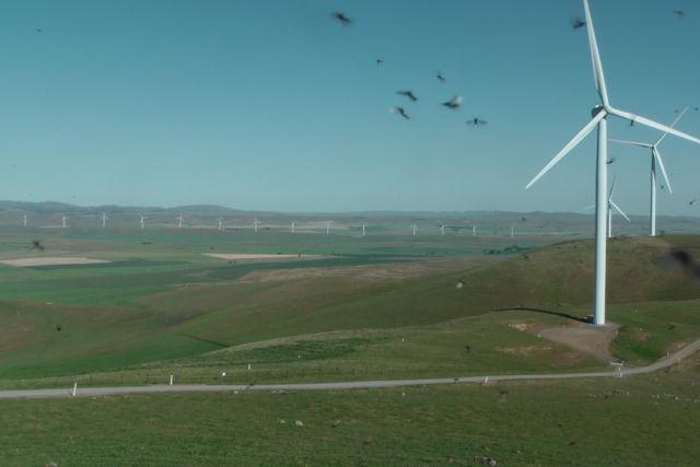
I travelled up the dirt road towards the top of the hills, through some gates, and then south along the ridge line to reach the remnants of the trig point. If you do access this summit, please remember to shut the gates, as cattle are kept in the paddocks amongst the wind turbines. The trig point now consists of three blue painted poles set amongst a clump of moss rocks. The views from here are truly grand, with a 360 degree panorama of the surrounding countryside. To adhere to the ‘activation zone’ rule for SOTA, I parked my car down the hill and walked up to the trig point.
Much to my displeasure, the trig point was absolutely alive with flies and bugs. Not really sure why. I guess they just wanted to call it home for the afternoon, and join me in a SOTA activation. Even the ‘Aerogard’ didn’t keep them away! The photo below is looking south east from the summit, and you can clearly see the very active flies and bugs, which were relentless!
I ran the little Yaesu FT-817nd again for this operation, running just QRP, 5 watts. My antenna was the Band Hopper 20m/40m linked dipole which I supported on the 7 metre squid pole. I used one of the trig point poles as an anchoring point for the squid pole, securing it with some octopus straps. Fortunately, the breeze had dropped and it was beautiful late afternoon on the summit. This was in stark contrast to my previous activation of this summit in July, 2013, when there was a howling westerly wind blowing.
One other thing different this time around, was that the noise floor was very low. Last time I activated this summit, there was a terrible squealing noise on the band, apparently generated by the wind turbines. But fortunately, the band was very quiet today.
Prior to calling CQ, I checked my phone and saw that Brian VK3MCD, was portable on SOTA peak, Mount Stanley, VK3/ VE-126, near Beechworth in north east Victoria. So I turned the radio on and tuned to 7.085 and there was Brian with a very nice 5/8 signal. After working Brian ‘summit to summit’, I tuned down to 7.080 and put out a CQ call and was greeted by Tony VK3CAT. This was followed by Larry VK5LY and my fourth qualifying contact was with Greg VK5ZGY who was mobile at Mount Gambier in the South East of South Australia.
This slideshow requires JavaScript.
The regular crowd of SOTA chasers then called in, from VK1, VK2, VK3, and VK5. Band conditions appeared to be quite good, with very good signals coming in locally from VK5, and from the eastern states. However, there didn’t seem to be the same number of SOTA chasers as normal. However, it was a weekday, and most people in Australia were either still at work or about to finish work.
After working a total of 21 stations on 40m SSB, I lowered the squid pole and removed the links from the dipole and then raised the squid pole back to its 7 metre limit. I was keeping a close eye on SOTAWatch on my iPhone and saw that there were a number of intended SOTA activations from the United Kingdom and Europe. So I was hoping for some ‘DX summit to summit’ contacts whilst I was on Brownhill Range.
One of those was Klaus DF2GN, who was portable on SOTA peak, Hohenkarpfen, DM/ BW-074. I saw Klaus had been spotted on 14.130, so I tuned down the band to that frequency and heard Klaus well, with a very good strong 5/8 signal. Klaus had posted that he was suffering from high VSWR when operating higher in the band, and thus the reason for being all the way down here. However, there was clearly no issue with Klaus’ antenna, as his signal was very strong. My only problem was, Klaus had a big pile up going, from both Europe and Australia. I called a number of times but just couldn’t break through the Australians calling him. After about 10 attempts, I heard Klaus come back to my call. Elation! Klaus gave me a 5/7 signal report, which I was very pleased with considering my 5 watts.
Hohenkarpfen summit is 912 metres above sea level, and is worth 10 points. It is an extinct volcano and is located near Spaichingen, Baden-Württemberg, Germany.
I then saw a spot for Barry, M0IML, who was portable on Dettling Hill, G/ SE-013. So I quickly tuned up to 14.327.5 and I was pleased to hear Barry coming through quite well, at about 5/4. Fortunately Barry was not quite as busy as Klaus, and it only took a few calls for Barry to respond with a 4/4 signal report for me. I was really excited…another ‘DX summit to summit’.
Dettling Hill is 200 metres above sea level and is worth 1 SOTA point. It forms part of the North Downs in Kent, a ridge of chalk hills. The summit is located north east of Maidstone, and is situated in the Kent Downs Area of Outstanding Natural Beauty. The name, taken from the village of Detling that sit at the foot of the hill, derives from Old English and means “hill at the settlement of the family of a man called Dyttel”.
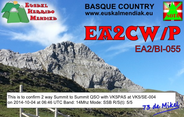
After working Barry I found a clear frequency on 14.295 and put out a CQ call. Much to my surprise, the first taker was Mikel EA2CW, who was portable on SOTA peak, Ganguren, EA2/ BI-055. Mikel was coming through at signal strength 5/5. Following Mikel, I received a call from Marcial, EA2BDS who was also on Ganguren, EA2/ BI-055.
Image courtesy of http://www.summitpost.org
A handful of stations followed on 14.295 including Viktor HA5LV, Paul VK2KTT, Dave VK4DD and Mike VK6MB. But I then saw a spot for Mike 2E0YYY who was portable on Shining Tor, G/ SP-004. So as it had gone a little quiet with callers, I quickly tuned to 14.285 and made contact with Mike who was a good 5/3 signal (5/3 received from Mike). Mike is the most prolific DX SOTA activator that I have worked.
The SOTA goat app then bleated on my i-phone, alerting me to Allan, GW4VPX who was portage on Mynydd y Betws, GW/ SW-028, on 14.280. I put a few calls out to Allan before being answered with a 4/4 signal report. Alan was a good 5/3 signal coming in to Brownhill Range. Mynydd y Betws is 374 metres above sea level and is worth 1 SOTA point.
Image courtesy of en.wikepedia.com
I then went back to 14.295 and put out some CQ calls, and Adam VK2YK responded. This was followed by Hans OE7PHI. And then to my surprise I received a call from Martin OE5REO who was portable on SOTA peak, Grillenparz, OE/ OO-316. Although Martin was not strong, and was only 5/1, he was perfectly readable due to the very low noise floor on the summit. I received a 3/1 signal report from Martin. Now I was really excited. This was my 9th summit to summit contact for the activation, and my 7th DX summit to summit. Grillenparz is 842 metres above sea level, and is with 2 SOTA points. Martin was running just 10 watts into a linked dipole on a 6 metre mast.
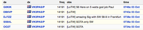
A number of DX stations followed from Austria and Germany. Sadly, an Italian station came up on 14.297 and was causing just too much QRM for me to continue on 14.295. So I tuned around the band and found another clear frequency on 14.191 and put out another CQ call, to be greeted by Albert S58AL. This was followed by a number of DX stations from Czech Republic, Belgium, Germany, Italy, France, and Sweden. All probably due to Albert’s efforts of placing me on the DX cluster. Many thanks Albert. There was also an original spot from OO2T (vanity call of ON5SWA). Thanks Francois ‘Swa’. Spots on the DX cluster are always extremely helpful.
I even got a call from my old mate Marnix, OP7M, who had seen me spotted on the DX cluster. I stayed with Marnix and his wife Martine, and son Goan, during my recent Europe trip. So it was a real pleasure to make contact with him. Particularly when conditions were so good. Marnix was an excellent 5/9 signal and with my tiny 5 watts I received a 5/7 signal report from Marnix.
One of the strongest signals of the afternoon was that of Steve, G0KIK. Steve had an excellent 5/9 plus signal coming in, and I received a 5/76 signal report. Steve also placed me on the DX cluster. Thanks Steve.
After the DX slowed down on 20m, I then went back to 40m and worked some of the stragglers, including Sam VK2AFA, Ian VK5CZ, Nigel VK5NIG and Rod VK5VRB.
So after 2 hours on Brownhill Range, it was time to head back to the hotel at Jamestown. I had a total of 57 contacts on 40m SSB and 20m SSB, including 9 summit to summit QSOs. I was very happy.
The following stations were worked:-
I have posted a short video on You Tube of the activation…..
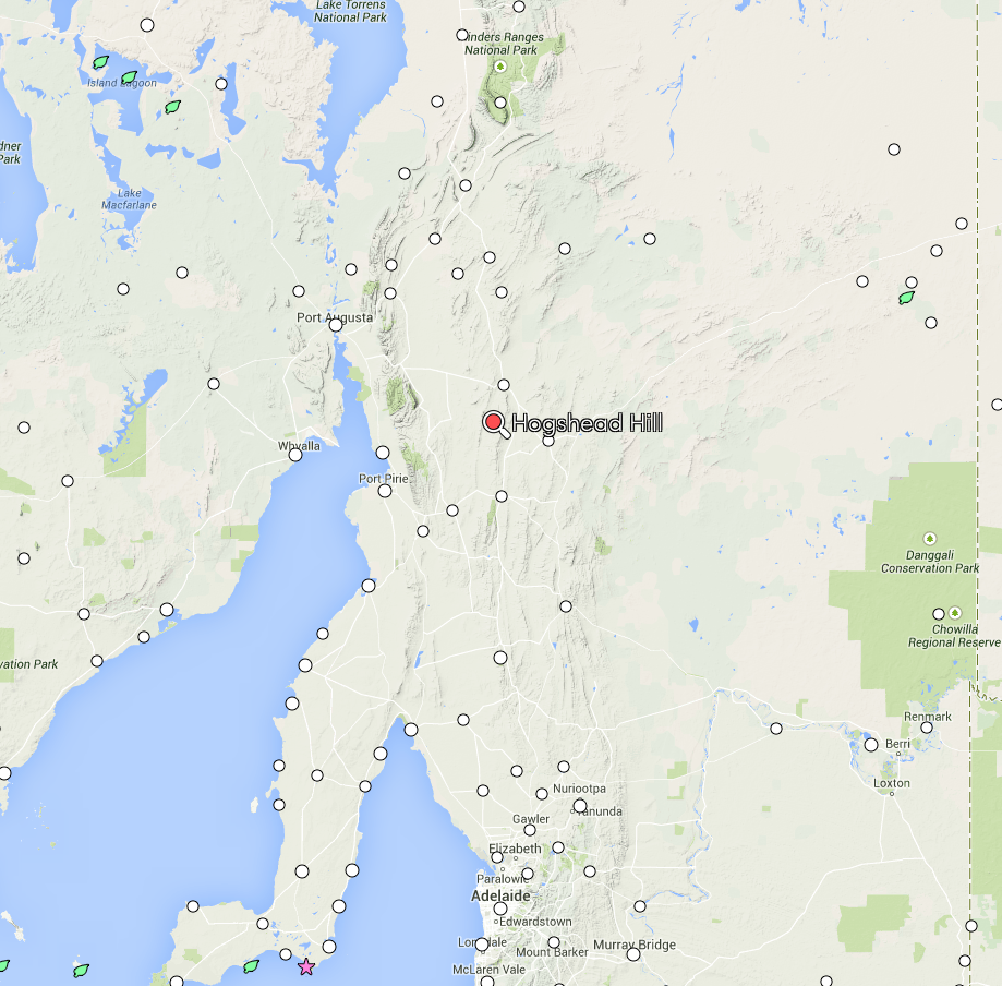
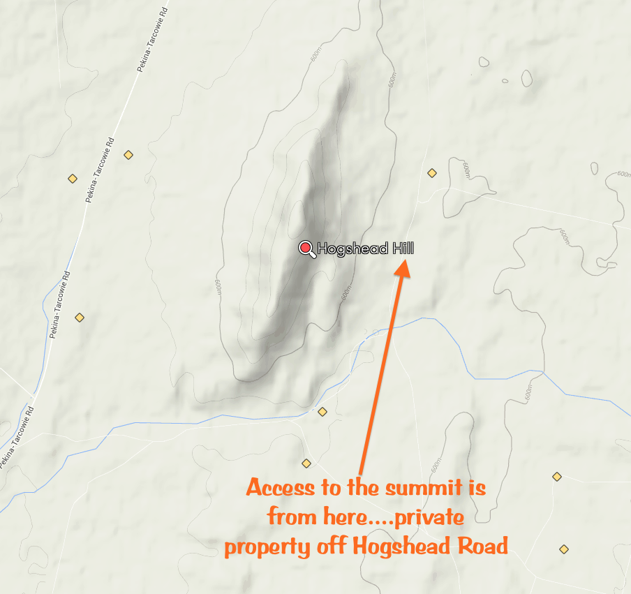
My second activation for Friday 3rd October, 2014, was Hogshead Hill, VK5/ NE-051, which is located about 7 km south east of the little town of Pekina in the mid north of South Australia (about 272 km north of Adelaide). It was just a short 60 minute drive north from my first activation at Mount Ngadjuri up to the town of Orroroo and then to Pekina.
Hogshead Hill is about 770 metres above sea level and is worth 4 SOTA points. I had previously activated the summit in August 2013 with Ian, VK5CZ. However, this was a new calendar year, and another 4 SOTA activator points were there for the taking. The summit is located on private property, so prior to access, please make contact with the owner (details can be found on the SOTA site under the Hogshead Hill listing).
Please refer to my previous post for some interesting facts on the summit and the nearby town of Pekina.
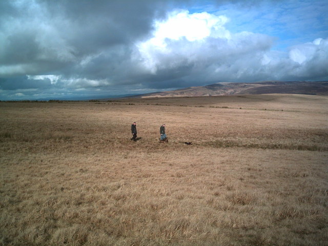
I accessed the summit via Hogshead Road. I had spoken to the land owner prior to access, and it appears that last time, Ian and I accessed the summit via his neighbour’s land. Fortunately there was no problem with us doing this, but this time I made sure I had very good directions regarding access. This time I parked my car on Hogshead Road, opposite a farmhouse on the eastern side of Hogshead Road. Directly opposite the farmhouse is a ‘cocky’s gate’. This is where I entered, following the scrub lined creek, up to a 2nd gate and fence line. As it turns out, there is a track leading through this paddock following the creek line which could be negated with care by a 2wd vehicle. However, I decided to leave my Falcon parked on Hogshead Road. At a recent service of my car, the mechanic had asked if I had gone off road, as there was a large build up of dirt under the car, along with some damage to the undercarriage.
The walk to the top of the summit takes between 45 minutes – 60 minutes. There is no formal track, and there is quite a bit of fence climbing and rock clambering to be done to reach the summit. It is a bit of a strenuous walk, particularly if the weather is warm, as it was on this day.
This slideshow requires JavaScript.
The creek line and summit were alive with kangaroos and euros. Many trying to shelter under the trees out of the sun. There were also quite a few sleepy lizards around in the long grass. This made me wonder, whether there were some snakes out and about as well. I am sure there were, but fortunately I didn’t encounter any.
Again for this activation I used the Yaesu FT-817nd and ran 5 watts. My antenna was the 20m/40m linked dipole, supported on the 7 metre squid pole. The temperature was creeping up into the mid 30’s, so I choose a shady spot under a tree to place the radio. I used a fallen tree to secure the squid pole with a few octopus straps. The top of this summit is a flat plateau, so there are plenty of options for establishing your station and erecting an antenna.
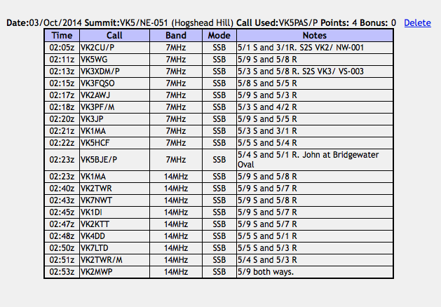
Just after setting up, my i-phone bleated at me, and I saw that Justin VK2CU was on the top of a summit in New South Wales. So I quickly tuned to 7.090 and there was Justin with a weak, but very audible signal. Justin was on the top of Mount Kaputar VK2/ NW-001, in north eastern New South Wales. The summit is also located within the Mount Kaputar National Park which qualifies for the World Wide Flora Fauna (WWFF) program. We exchanged signal reports (5/1 sent and 3/1 received), and I then moved up to 7.095 where I put out a CQ call, only to be greeted by the ever keen, Nev, VK5WG, with a very strong 5/9 plus signal.
It was a week day, and it was the middle of the day, so a lack of SOTA chasers and band conditions were conspiring against me. As we all know, the 40m band tends to ‘go to sleep’ during the middle of the day. But I pressed on and made a total of 10 contacts on 40m SSB into VK1, VK2, VK3, and VK5, before lowering the squid pole and removing the links in the dipole, for 20m.
I then tuned to 14.310 and my first caller on 20m was Matt VK1MA who had a very good 5/9 signal (5/8 received). Mike VKMB then called me, but despite our best efforts, I was just not able to get a signal report through to Mike who was very weak (5/1), but very audible on the summit due to the very low noise floor. If only it was like that in everyone’s homes. I had similar problems with Ron VK3AFW who called and called and called, but sadly I just could not exchange a signal report with him for a valid contact. Conditions however, to New South Wales, the ACT, and Tasmania appeared quite good.
I operated on the summit for about 50 minutes, before deciding to pack up and head down, and off to the next summit. I had a total of 19 stations in the log on 40m SSB and 20m SSB.
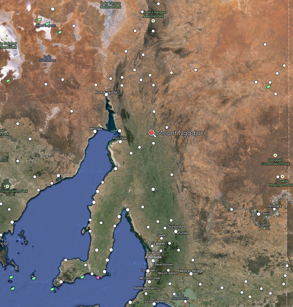
On Thursday night I stayed at the Commercial Hotel at Jamestown. The room was small and basic, but very clean and all I needed for my 2 nights stay in the town, so I could activate some of the nearby peaks for the Summits on the Air (SOTA) program. Sadly, other than Mount Lofty and Mount Gawler and VK5/ SE-016, the nearest summits to me are located a minimum of 100 km away. That is despite the fact that I live in the Mount Lofty Ranges. Yes, I know, I live in the ‘mountains’ but only 2 nearby summits qualify for SOTA. Go figure! One of those quirky rules of SOTA….150 metres of prominence. So after breakfast, I packed up my gear and headed north out of Jamestown to Mount Ngadjuri, VK5/ NE-058. This was my second time to Mount Ngadjuri. I had previously activated the summit in July, 2013, and as this was a new calendar year, another 4 SOTA points were up for grabs.
Map courtesy of mapcarta.com
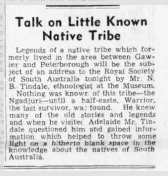
Mount Ngadjuri is 755 metres above sea level, and as mentioned is worth 4 SOTA points. The summit is incorrectly spelt on the SOTA site as ‘Nadjuri’. It is correctly spelt as ‘Ngadjuri’ after the local Ngadjuri aboriginal tribe. I found the article below, which appeared in The News, on 12th August 1937. Interesting how terms that are totally taboo now, were obviously commonplace way back then.
Courtesy of trove.nla.gov.au
Today, the area around Mount Ngadjuri is used for agricultural purposes. However, prior to Europeans settling in the area, the Ngadjuri aboriginal people inhabited the area and led nomadic lives living off the land. I would imagine that Mount Ngadjuri itself would have been an important point in the landscape for the Ngadjuri tribe. Sadly, their numbers were decimated by introduced European diseases, including smallpox. By the 1870s few of the Ngadjuri remained on their traditional lands and most of those left had become dependent upon the white population through land dispossession. Although there were some late attempts to arrest their decline, by the end of the nineteenth century the language group, as it had been, had ceased to exist.
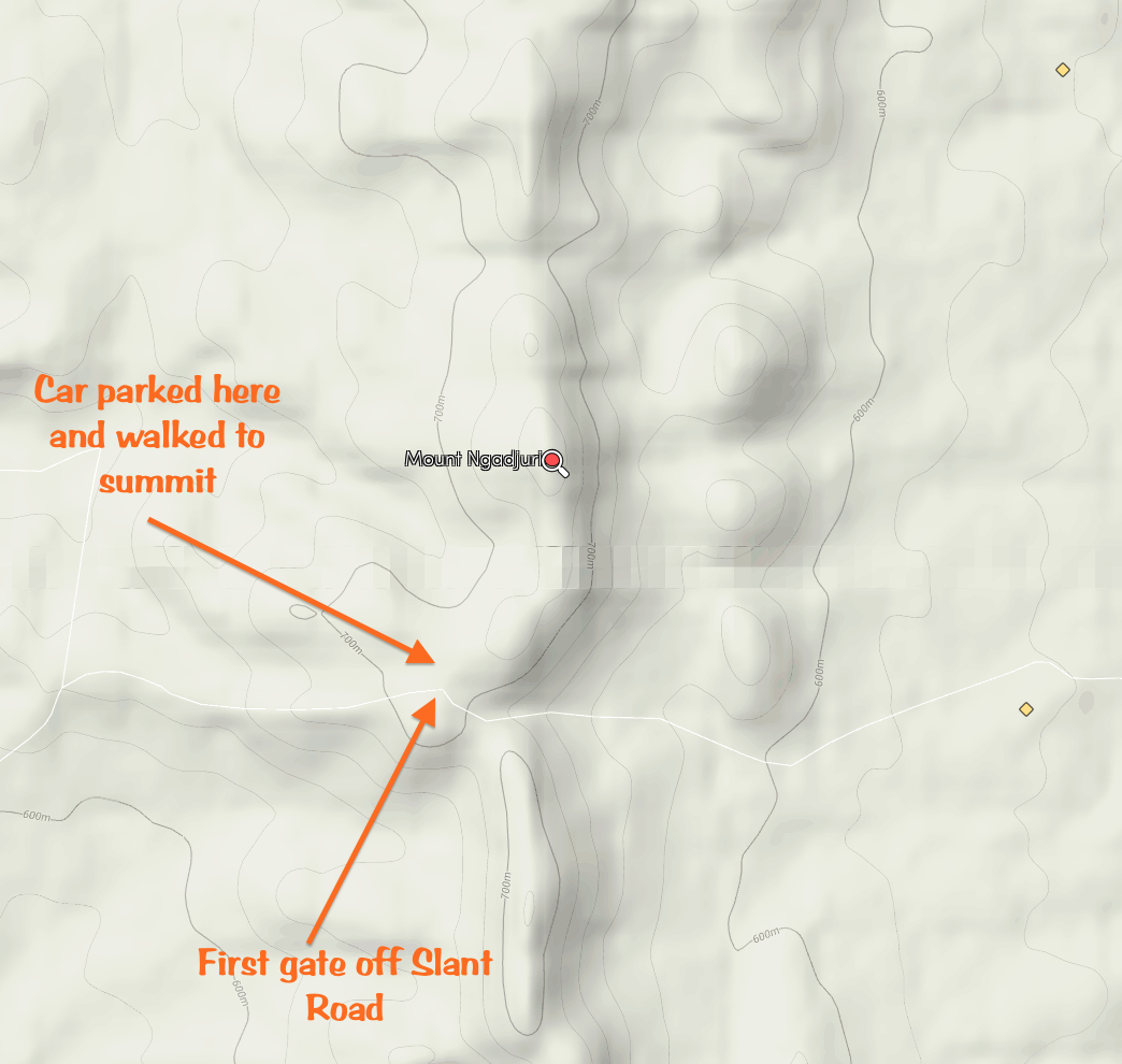
As per my last activation, I accessed the summit by travelling west along Slant Road, which runs off the western side of RM Williams Way. Slant Road is about 13 km north of Jamestown. You need to travel up Slant Road to the hills and through the gorge. You will reach a point at the top of the hills, where you will see a gate on your right with a rapid number of ‘730 403’ on it. This is where you need to enter. However, remember that the summit is on private property. So prior to entry, please obtain permission from the landowner. Details can be found on the SOTA site under the notes for Mount Ngadjuri.
map courtesy of googlemaps.com
I parked my car at the second gate which is a short drive through the paddock, and walked the remainder of the way to the actual summit, which is a distance of about 1.5-2 km. The walk is quite easy and certainly not at all taxing. This particular morning was much more pleasant than my last activation. In July 2013, it was a cool foggy morning. But this morning was beautiful and clear. Even though the sun was out, I still saw quite a few kangaroos in the paddocks amongst the sheep.
This slideshow requires JavaScript.
There is no trig point at the summit. However there is a rock cairn. There is also no shelter on the summit, and it does tend to get quite windy there. So I tried to nestle as close as I could to the rock cairn, to get out of the blustery westerly winds.
For this activation I used my Yaesu FT-817nd and ran just 5 watts. I powered the radio with a 12 volt 4 ah sealed lead acid battery. My antenna was the BandHopper 20m/40m linked dipole, which I supported on a 7 metre squid pole.
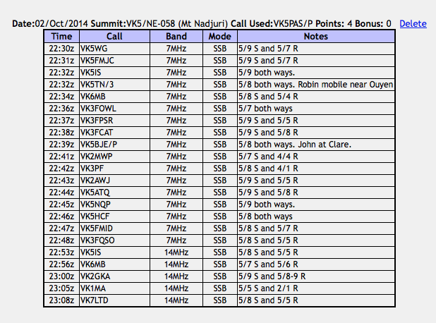
I started off on 40m SSB, with my first contact being with Nev VK5WG at nearby Crystal Brook (about 68 km to the south west by road). As expected, Nev had a very strong 5/9 plus signal. This was followed by John VK5FMJC, also in Crystal Brook, and then Ian VK5IS running QRP 5 watts from nearby Beetaloo Valley. Robin VK5TN was my saving grace, as my fourth and qualifying contact for the summit. Robin was mobile near Ouyen in Victoria and had a very good 5/8 signal. My next contact was with Mike VK6MB in Western Australia. It is often a challenge to work Mike on 40m, but this morning, conditions were good, and Mike was a good strong 5/8 and reciprocated with a 5/4 signal received.
As it was a weekday, it was a bit slow going on 40m. Certainly not the hectic operating conditions with the normal mob of SOTA chasers that you experience on a weekend activation. So after working a total of 17 stations on 40m SSB, I ventured up to 20m and put out a CQ call on 14.310 which was answered by Ian VK5IS. This was followed by another contact with Mike VK6MB, who surprisingly was weaker on 20m than he was on 40m. I worked a further 3 stations on 20m in VK1, VK2, & VK7.
After 40 minutes on the summit, it was time to pack up and head off to the next summit. I had a total of 22 stations in the log on 40m and 20m SSB. Sadly, I didn’t manage any summit to summit contacts during this activation.
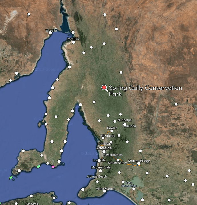
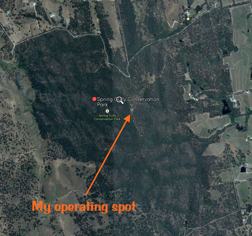
On Thursday 2nd October 2014, I activated the Spring Gully Conservation Park (CP) in the Clare Valley. I left work early on the Thursday afternoon, and headed towards Jamestown in the Mid North of South Australia, where I planned to stay for 2 nights and activate some of the nearby summits for the Summits on the Air (SOTA) program. However, I had a little time up my sleeve on the Thursday afternoon, so I popped in to the Spring Gully CP on the way. And why not, it was a beautiful sunny day….temperature about 25 deg c.
The park is located about 8 km south of Clare in what is called the Skilly Hills, in the Mid North of South Australia. The park is about 400 hectares in size, and conserves a considerable area of grassy woodland in what is generally a cleared and settled landscape in the Clare district. In 1962, the original 15 acres of the park was gazetted as a wildlife reserve. This was later extended to include the springs that give the park its name. There is a seasonal waterfall within the park, which plunges from a height of 18 metres following rain.
Spring Gully CP was originally created to protect the only stand of Red Stringybark (Eucalyptus macrorhyncha) trees in South Australia. This eucalypt is widespread in eastern Victoria and eastern New South Wales, but is very rare in South Australia. The trees gain their name from their red trunk once their fibrous bark is removed. These trees are delicately placed, as thousands died following the extremely dry period between mid 1007 to early 2008. A small section of the park was also burnt during a lightning ignited bushfire in November, 2009. The park also protects White Spider Orchids, Donkey Orchid, and Sun Orchid, and other smaller plants below the canopy in the grassy woodland ecosystem.
Prior to European occupation of the area, the land on which the park is located on, was frequented by the local Ngadjuri aboriginal people, providing an abundance of food. However, upon the arrival of the Europeans, the area was extensively used for logging timber and for the grazing of stock.
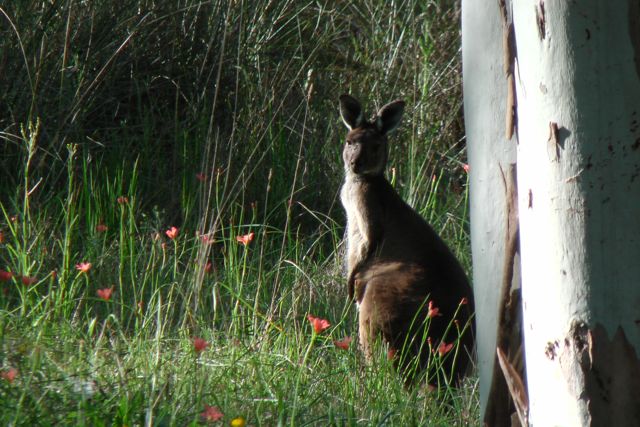
The park is inhabited by a variety of wildlife including Western grey kangaroos, euros, echidnas, and Common brush tail possums. Over fifty species of birds have been recorded in the park including numerous parrots, and kookaburras. There was certainly no shortage of kangaroos, with quite a few spotted both on the way to the park, and also within the park itself.
I accessed the park by travelling off Horrocks Highway, onto Bayes Road, then left onto Hughes Park Road, and then right onto Sawmill Road. At the hairpin on Sawmill Road, there is a dirt track (Ridgetop Track), which will take you all the way up to the lookout within the park. The lookout is where I decided to set up. There are a number of other possibilities in the park, including the Blue Gum Lookout day visitor area.
There is plenty of room at the lookout to string out a dipole, which is exactly what I did…erecting my 20m/40m Band Hopper linked dipole, which I supported on the 7 metre squid pole. For this activation I ran QRP 5 watts with the Yaesu FT-817nd, powered by a 12 volt 4 ah sealed lead acid battery.
I had notified some of the keen VK5 Park Hunters of my intentions, so when I asked if the frequency was in use on 40m, I was welcomed by a number of the regulars. My first contact was with Col VK5HCF down in Mount Gambier in the South East of South Australia. Col was running his usual QRP 5 watts and had a very nice 5/9 signal to the park. This was followed by David VK5KC and John VK5BJE, who were both portable at the caravan park at Clare, just down the road. Not surprising that they had 5/9 signals. Greg VK5ZGY then called in and this was followed by Nick VK3NAL who was low down in signal strength and was also struggling with my low powered signal. Nether less, we managed to make the contact which is all that counts.
A number of the regular VK5 Park Hunters called in after this, along with Ron VK3JP who has become a regular park hunter during my recent activations. I also received a call from Bill VK5WCC at Millicent in the South East. I was Bill’s first ever park contact. Welcome to the world of park hunting Bill. It was also good to speak with Ivan VK5HS who was mobile with a very good 5/8 signal.
About half way through the activation, I had some visitors….. David VK5KC and John VK5BJE. After a quick chat, we organised to catch up for a quick ale once my activation was complete, and advised that Ian VK5CZ would also be joining us.
My last contact was with Brian VK3MCD who was portable on Mount Baranduda, VK3/ VE-189, for the SOTA program. Brian and a good 5/5 signal coming in from north eastern Victoria, and I received a 5/7 signal report from Brian.
So after 30 minutes in the park, I had a total of 16 contacts in the log, from VK3 and VK5. It was time to pack up and head off to catch up with David, John, and Ian at the caravan park. ‘Beer o’clock’! Thanks to everyone that called in.
The following stations were worked:-
Col VK5HCF; David VK5KC/p; John VK5BJE/p; Greg VK5ZGY; Nick VK3ANL; Ian VK5CZ; Bill VK5WCC; Matt VK5MLB; Larry VK5LY; Tom VK5FTRG; Ron VK3JP; Brian VK5FMID; Arno VK5ZAR; Col VK5FCDL; Ivan VK5HS/m; and Brian VK3MCD/p (SOTA).


 A number of the regular VK5 Park Hunters called in after this, along with Ron VK3JP who has become a regular park hunter during my recent activations. I also received a call from Bill VK5WCC at Millicent in the South East. I was Bill’s first ever park contact. Welcome to the world of park hunting Bill. It was also good to speak with Ivan VK5HS who was mobile with a very good 5/8 signal.