
Yesterday (Sunday 31st January 2016) was such a beautiful afternoon, that my wife Marija and I decided to go for a drive. The day had started off nice and sunny, but by mid morning the clouds had rolled in and the sky was looking a little threatening. But by mid afternoon it had cleared up to a fine and sunny day. We packed the 4WD and headed for the Marne Valley Conservation Park, 5CP-128 (for the VK5 Parks Award), and VKFF-0906 (for the World Wide Flora Fauna (WWFF) program).
I had activated this park before, back in March, 2015, but that was prior to the park being added to the WWFF program. So this was to be a unique VKFF activation for me. For more information on my previous activation, please see…..
https://vk5pas.org/2015/03/11/marne-valley-conservation-park/
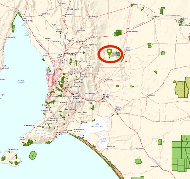
Above:- Map showing the location of the Marne Valley Conservation Park. Image courtesy of Location SA Map Viewer.
Marne Valley Conservation Park is around 80 km to the north east of my home QTH. The park is situated around 30km north east of Mannum on the Murray River, about 5 km east of the little town of Cambrai, and about 90 km east of Adelaide.
We drove out through Woodside, Charleston, and the historic little town of Mount Torrens, and then on to Birdwood where the National Motor Museum is located. We continued on to Mount Torrens where we took the Angas Valley Road to Sanderson and Angas Valley. We then turned right onto Ridley Road and headed towards Cambrai. This is a nice drive.

Above:- Map showing the location of the park. Also indicating the Barossa Valley, the Murray River, & my home QTH. Image courtesy of Location SA Map Viewer.
As we drove east along Angas Valley Road, there are some amazing views to be had from the rugged slopes of the Mount Lofty Ranges. We could see clearly out to the east, with the white silos at Cambrai visible in the distance. The hills here are quite rugged and I have driven through here many times, wondering who some of these hills don’t qualify for the Summits on the Air (SOTA) program. I guess sadly, they do not have the required 150 metres of prominence.


As we approached the town of Cambrai, we crossed over the Marne River. The river was formerly known as the Rhine River South, but during World War One, anti German feeling ran high in South Australia. South Australia had a large population of people from a Germanic background, formerly from the Kingdom of Prussia (which is now current day Germany, Poland, and Slovakia). Despite these people pledging their allegiance to the British Crown, the anti German frenzy spread wide and by 1917 a Nomenclature Committee had been established which recommended that all names of places that were of ‘foreign enemy origin’ would be changed.
The Rhine River South soon became known as The Marne (in 1971 changed to the Marne River). The book entitled ‘South Australia. What’s in a name?“, written by Rodney Cockburn states……
“Marne River – was formerly the South Rhine River, and the present famous battle name was bestowed by the Peake Government in 1917 when the maps were purged of the ‘enemy’ element”.
The nearby town of Rhine Villa, became known as Cambrai. Nowadays, Cambrai is a small town situated in an extensive farming district on the eastern side of the Mount Lofty Ranges. ‘South Australia. What’s in a name?‘ states…..
Cambrai – Hundred of Angas, is memorable as a storm centre in the history of the Great War. In South Australia it was originally Rhine Villa, which disappeared when the enemly elemnt in the State’s nomenclature was dealt with. Many years ago there was a house or hut with a comical villa front where Cambra now stands. A person named Skinner occupied it and called it ‘The Villa’. A little township grew up around it and got the name of Rhine Villa, because of the proximity of the River Rhine’.


After passing through Cambrai, we turned right onto the Black Hill Road. Keep an eye out for the cemetery which is located on the corner.
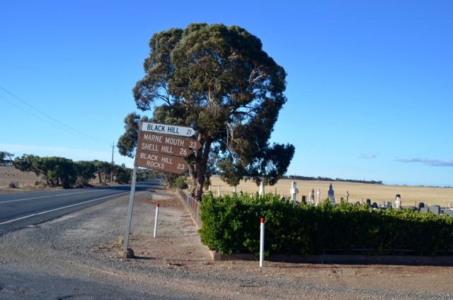
Above:- the turn off to Black Hill.
It wasn’t long before we started to see some of the turf farms for Marne Valley Turf. Lawn or turf, has been grown here since 1990, supplying instant lawn to home owners, landscapers, councils, etc. If you continue along Black Road, you will reach the Murray River. Shell Hill can also be acccessed, which is just a short distance from Black Hill. It is here that oyster shell deposits, which in some places are 6 metres thick from the Miocence era, are believed to be millions of years old.

Above:- One of the turf plots.
We accessed the park from the southern side, off Black Hill Road. There is a short dirt track leading to a locked gate. A park sign exists at this location. Looking at some maps, it also appears that you can access the park from its western boundary off Tarnkes Road, and also the northern side of the park, off Havelberg Road.

Above:- Map showing our operating spot within the Marne Valley CP. Image courtesy of Location SA Map Viewer.
Marne Valley Conservation Park is about 105 hectares in size and was dedicated in 1976. The park is bisected by the Marne River, with the landscape of the park being gently undulating. Most of the park consists of low lying, seasonally inundated River Red Gum flats. The River Red Gum open forest is very thick in parts. Sadly, much of the native vegetation has been cleared in the south western corner and the northern section of the park.
Most of the mighty River Red Gums were cleared from the park and the surrounding land back in the late 1880’s. A saw mill existed in the area, with the local Red Gum being considered superior to many other varieties for use as railway sleepers.


The Marne River Valley also formed part of the main Adelaide to Sydney stock route. Prior to motorised rail and road transport, overlanding or droving cattle were the only means of transporting cattle to markets back in the good old days, or from property to property. Most of these routes followed, depended on water availability, and the Marne River would have provided a regular supply of water. The Statistical Registrar of SA, 1884, estimates that 32,000 cattle were moved along the travelling stock reserves.


Above:- A typical stock route, and a map showing some of the stock routes in South Australia, c. 1920’s. Images courtesy of Trove.
The fenceline here has not been attended to in years and is falling down. So, the locked gate made us laugh a little. There is also a National Parks & Wildlife sign here, dating back many years. I don’t think DEWNR have probably been out to this park in years and years. The Management Plan, which is now 22 years old, refers to a visitor access track running along the western boundary from the south to a ‘picnic and camping area’. This is no longer the case, with the park being locked by gates.
We used one of the old redgum fence posts to secure the 7 metre telescopic squid pole, with the assistance of an octopus strap. I set up the Yaesu FT-857d on the fold up table, and made myself comfortable on the deck chair.
As was the case last time I was here, the park was alive with Kookaburras. In fact at one stage Marija commented that she wasn’t sure if it was a live kookaburra or parksnpeaks going off.


I was on air and ready to go by 0555 UTC (4.25 p.m. South Australian local time). I was about 25 minutes late from my posted activation time. I headed to 7.144 and asked if the frequency was in use, and a number of voices came back saying ‘no Paul, all clear, we’ve been waiting for you’. The first station in the log for this activation was Dennis VK2HHA who had a lovely 5/9 signal coming in from Albury. This was followed by Mark VK5QI mobile in VK3, near Geelong. Mark’s mobile set up was certainly working well, as he was a strong 5/8. Most of the regular crowd of park hunters followed, from VK2, VK3, VK4, VK5, and VK7. The 40m band was working well, with some very strong signals and some low down static crashes.
But this was shortlived. I was in the middle of a QSO with Wayne, VK3FADM, when the very quiet band, suddenly changed in a heartbeat. I had an S9 plus noise come up on the frequency, which I initially suspected mat have been from the solar panels. But after diconnected the solar panels, the noise was still there. I was a good 200 metres away from the nearest power lines, and around 400 metres away from the nearest farmhouse. I suspect that is where the noise was coming from.
I worked a total of 34 stations on 40m, including Nigel VK5NIG who was activating Mount Gawler summit, VK5/ SE-013 for the SOTA program.
I then headed over to 20m where I worked a total fo 12 stations on 14.310, from VK1, VK2, VK3, VK4, and VK6. This included two Western Australian stations: Wes VK6WX in Mount Barker, WA (the same name as my home town), and Mike VK6MB (who advised that he could marginally hear me earlier on 40m).


I then went back briefly to 40m to pick up any park stragglers. I worked just 8 stations, but I was very pleased to get two Foundation calls in the log from Queensland who both had nice 5/7 signals: Rob VK4FFAB, and Owen VK4FADW.
Time was marching on, so I packed up the 20m/40m linked dipole, and erected the 15m dipole, and started calling CQ on 21.242. I couldn’t get to 21.244 as there was a light JA on 21.245. My first taker on 15m was Rick VK4RF/VK4HA who was 5/9 plus, followed by Rob VK4FFAB who was a little weaker here on 15m, than he was on 40m. I worked 14 stations on 15m from Japan, Indonesia, VK2, VK3, VK4, and VK5. This included Nigel VK5NIG on Mount Gawler, for a second band. Mick VK3PMG called in for a third time, so a clean sweep for all 3 bands for Mick. And Gerard VK2IO also called in, picking me up on all 3 bands.
Marija had been patiently waiting back in the Hi Lux, watching movies on her iPad, so it was time to pack up and head home. I had a total of 68 contacts in the log after approximately 2 hours in the park.
The following stations were worked on 40m SSB
- VK2HHA
- VK5QI/3
- VK5NRG
- VK3PF
- VK2PKT
- VK5NM
- VK2LEE
- VK4RF
- VK4HA
- VK3SIM
- VK7CW
- VK5TR
- VK3MCK
- VK2YK
- VK3NBL
- VK3ARH
- VK3PMG
- VK5FANA
- VK3AWG
- VK3GTS
- VK5STU
- VK4AAC/5
- VK5KPR
- VK5FCLK
- VK3TKK/m
- VK3FADM
- VK5NIG/p (SOTA VK5/ SE-013)
- VK5YX
- VK3FMJM
- VK1AT
- VK3DAC
- VK5ZGG
- VK2IO
- VK5WG
- VK2HOT
- VK3FJD
- VK4FFAB
- VK4FADW
- VK5JK
- VK5PZ
- VK5VRB
- VK3ZZS/p
The following stations were worked on 20m SSB:-
- VK4RF
- VK4HA
- VK3MCK
- VK3WE
- VK2HOT
- VK6WX
- VK3PMG
- VK2LEE
- VK6MB
- VK1OO
- VK4MON
- VK2IO
The following stations were worked on 15m SSB:-
- VK4RF
- VK4HA
- VK4FFAB
- VK5NIG/p (SOTA VK5/ SE-013)
- VK3AG
- VK4FADW
- VK3PMG
- JA8XOK
- VK2IO
- VK2LEE
- VK3HMV
- YC9DEB
- VK3FADM
- VK3OF
On the way home we called in to the Totness Inn at Mount Pleasant for a meal and I indulged in a few cans of Bundy and rum. I then enjoyed a ‘papa knap’ on the way home, with Marija at the wheel.


References.
Family History SA, 2016, <http://www.familyhistorysa.info/sahistory/germanplacenames.html>, viewed 1st February 2016
Government of South Australia, 2016, <http://pir.sa.gov.au/aghistory/livestock/beef/transportation/stock_routes>, viewed 1st February 2016
