
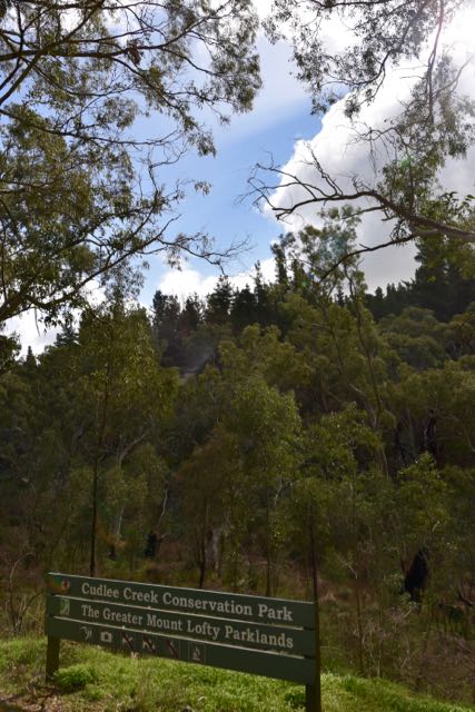
We had been forecast some very average weather today (Saturday 23rd July 2016), but fortunately it held off nicely for me to head out to the Cudlee Creek Conservation Park VKFF-1023 and 5CP-050. The last time I had been to this park was way back in July 2013, so this was to be a unique park activation for me for the World Wide Flora Fauna (WWFF) program.
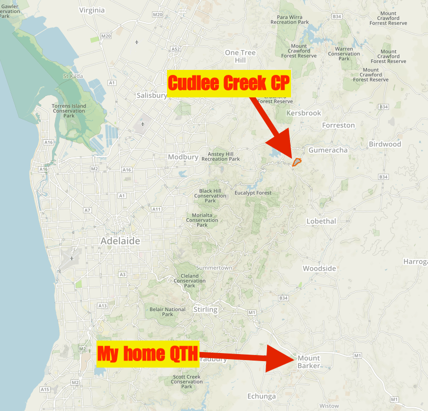
Above:- Map showing the location of the Cudlee Creek Conservation Park. Image courtesy of Protected Planet.
The park is situated just to the east of the little town of Cudlee Creek in the Mount Lofty Ranges ‘Adelaide Hills’, about 33 km north east of Adelaide. The name Cudlee Creek is believed to be local aboriginal for Dingo’s Creek or wild dog crossing. The first European inhabitants of Cudlee Creek settled in the area in 1838, just 2 years after the settlement of the State of South Australia. William Kelly, from the Isle of Man, settled in the area and established the Sulby Glen Estate which was well know for its cheese making. Cudlee Creek also became an exporter of fruit, in particular apples and pears. A coldstore and packing shed was built in the town in 1922.
Today the population of Cudlee Creek is around 450 people. The Gorge Wildlife Park, one of the largest privately owned animal parks in Australia is located at Cudlee Creek. The old icecreamery in Cudlee Creek has now been converted into a cafe/restaurant and this was very busy as I passed through the town.
The River Torrens passes through the town. The Torrens is the most significant river of the Adelaide Plains and was one of the reasons Adelaide was sited where it is today. It flows about 85 km through the Adelaide Hills to its mouth between Henley Beach and West Beach. The historic Union bridge crosses the Torrens at Cudlee Creek. The original timber bridge was built in 1871 and was known as ‘Ledgards Bridge, and in 1917 was replaced with the current steel and concrete arched bridge.


The Cudlee Creek Conservation Park was proclaimed in 1971 and is home to a variety of native birds and animals who live in the woodlands on the steep hillsides. Native animals that are found in the park include Western Grey kangaroos, and echidnas. The River Torrens passes through the park on its southern border and after the recent rain was flowing very well.
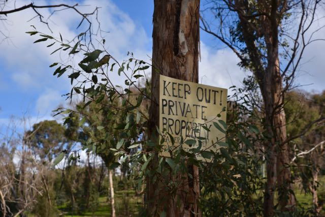
Access to the park is limited. There is no access to the north of the park. I first approached the park from its western side (from Cudlee Creek township). There is a small parking area near the park’s sign, so you can get your vehicle off Gorge Road.
But I decided to continue east on Gorge Road towards North East Road, hoping that I would find another possible operating spot. At the north eastern corner of the park I saw a small cleared area with a track leading down towards the river. I was a bit confused as my GPS was showing that this was inside of the park, but there was a ‘Keep Out’ sign here. I saw a 4WD ute parked down near the river so I drove down the track and found a fella down on the banks of the river. As it turned out he was panning/screening for gold. I asked him if he was the owner or if he knew that this area was private property. He replied that he wasn’t the owner but that he believed it was private property as the owner had told him and his friends to leave on previous occasions. I decided it wasn’t worth staying in this spot, and headed back towards the parking area further back along Gorge Road.
The Cudlee Creek Conservation Park was devastated during the Sampson Flat bushfire in January 2015. The fire destroyed 27 houses and burnt more than 20,000 hectares (49,000 acres) of land. The park was closed for a significant period of time following the fire. I was very pleased to see that although there were still visible signs of the fire, much of the bush had started to regenerate.


I set up in the south western corner of the park just off Gorge Road. This was a picturesque spot and overlooked the River Torrens. I used the park sign to secure the 7 metre squid pole, with the assistance of the always handy octopus straps. I set up and deck chair, fold up table and Yaesu FT-857d and got to work.
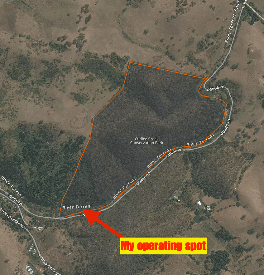
Above:- Map showing the location of my operating spot in the Cudlee Creek Conservation Park. Image courtesy of Protected Planet.
I was set and up and ready to go by just after 0400 UTC (1.30 p.m.) which was the time I had posted on parksnpeaks and Facebook as my starting time in the park. I headed to 7.144 and asked if the frequency was in use and the familiar voice of Dennis VK2HHA came back to let me know it was clear. So Dennis was my first contact, followed by Marc VK3OHM, Greg VK5GJ at Meadows running just 4 watts, and then Damien VK5FDEC at Elizabeth running 5 watts.
Band conditions on 40m appeared to be quite good but it was noticeable that there were not as many callers as I’ve experienced during recent activations. Conditions must have been good as I made contact again with Mike VK6MB in the middle of the day on 40m. Although the busy Gorge Road was in close proximity to my operating spot, traffic was fairly light and it was fairly quiet. All except for the occasional ‘weekend warrior’ on their motorcycle. The Gorge Road is notorious for motorcycle riders and there have been a number of fatalities on Gorge Road over the years. Not surprising when you see how some of these guys ride along that section of road.


After working a total of 43 stations on 40m from VK1, VK2, VK3, VK5, VK6, and VK7, I headed over to 20m. This included a Park to Park contact with Neil VK4HNS who was operating portable in theBorder Ranges National Park VKFF-0047. I first checked out the ANZA DX Net on 14.183 and was very concerned to hear signals very low down. John VK4LJ who normally pounds in was extremely low. So I headed up to 14.310 and started calling CQ and this was answered by Rick VK4RF/VK4HA, followed by Mike VK6MB. But that was it for callers on 20m. So it was down with the 40m/20m linked dipole and up with the 15m dipole.


I called CQ on 15m on 21.244 and this was answered by Mike VK6MB. Despite the fact that signals were quite good (5/7 both ways), Mike was my only contact on 15m despite numerous CQ calls and a self spot on parksnpeaks.
The weather was moving in rapidly from the west and I was getting a few drops of rain, so it was an opportune time to pack up and head home. I was content with 47 contacts in the log and another unique park qualified.
The following stations were worked on 40m SSB:-
- VK2HHA
- VK3OHM
- VK5GJ (QRP)
- VK5FDEC (QRP)
- VK3GGG
- VK3PMG
- VK3SIM
- VK3TKK
- VK5BJE
- VK3IO
- VK3GYH
- VK4AAC/3
- VK5KLV
- VK7CW
- VK6MB
- VK5TN
- VK3MCK
- VK5FMID
- VK2IO
- VK5ZEA
- VK2IF
- VK3BL
- VK3ZPF
- VK5FANA/m
- VK2YK
- VK3ANL
- VK3ELH
- VK5FD
- VK3FIRM
- VK2KYO
- VK4CPS
- VK5FAKV
- VK3PF
- VK1DI
- VK2PKT
- VK4HNS/2 (Border Ranges National Park VKFF-0047)
- VK2EXA
- VK3MRH
- VK6JON/7
- VK4FAAS
- VK3FPSR
- VK3KRH
- VK3NE
The following stations were worked on 20m SSB:-
- VK4RF
- VK4HA
- VK6MB
The following stations were worked on 15m SSB:-
- VK6MB
References.
Wikipedia, 2016, <https://en.wikipedia.org/wiki/Cudlee_Creek>, viewed 17th July 2016
Wikipedia, 2016, <https://en.wikipedia.org/wiki/2015_Sampson_Flat_bushfires>, viewed 17th July 2016
Weekend Notes, 2016, <http://www.weekendnotes.com/cudlee-creek-walk/>, viewed 17th July 2016
The Gummeracha & District History Centre Inc, <http://www.gumeracha.com.au/otherPages/history/>, viewed 17th July 2016

Good effort again Mate. Cudlee Ck has been on my radar for a while as a ‘nearby’ park and I don’t want to take the ‘low hanging fruit’ so to speak until I really need to!
Chris
VK4FR
Hi Chris,
There aren’t too many operating spots here at Cudlee Creek. Where I operated from was ok, but if you wanted to get deep into the park, you’d have to cross over the Torrens River, which wasn’t an option when I was there after all the recent rain. I can’t see any access options from the north.
Cheers,
Paul,
VK5PAS.