
I was already running behind schedule for my second park of the day and it wasn’t going to get any better. Access to the Nepean Bay Conservation Park 5CP-159 and VKFF-1067 proved a little trickier than originally planned. So if I sounded a little flustered or grumpy during this action, you’re about to read why.
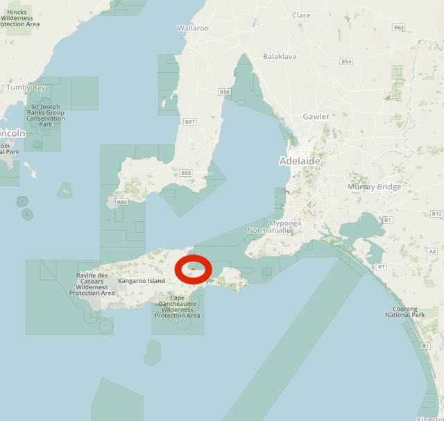
Above:- Map showing the location of the Nepean Bay Conservation Park on Kangaroo Island. Image courtesy of Protected Planet.
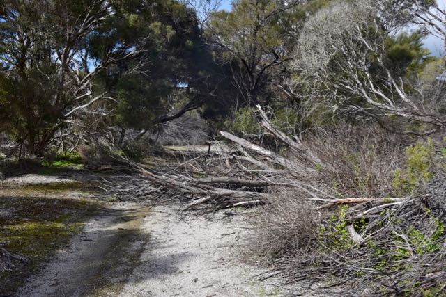
After leaving Cygnet Estuary with wet feet I headed south east along the Hog Bay Road and into the little settlement of Nepean Bay. My plans were to travel along Sea Vista Road. But what appeared on the maps as a road, is little more than a very neglected 4WD track. And many sections were impassable (see below). So this park required a bit of walking and carrying of gear to get into as well.
The only pleasing thing was that the view of Nepean Bay was truly beautiful. And the weather on Kangaroo Island, despite it being August, was mild and slightly overcast, with plenty of blue sky.


Nepean Bay was named by Captain Matthew Flinders (1774-1814) on 21st March 1802 after Sir Evan Nepean. Sir Evan was a British politician and colonial administrator.


Above:- Captain Matthew Flinders (left) and Sir Evan Nepean (right. Images courtesy of Wikipedia.
Nepean Bay Conservation Park comprises 32 hectares (79 acres) and was proclaimed on 11th July 1974. It was dedicated for the protection of flora and fauna, and is the only reserved area of coastal sandplain on Kangaroo Island. The park lies on the southern shoreline of Western Cove in Nepean Bay, about 1.5 kilometres to the east of the Nepean Bay settlement, and about 9 km south of Kingscote.
The park’s vegetation is mostly an open scrub of Eucalyptus diversifolia and Callitris preissii with areas of low shrubland, tussock sedgeland and Allocasuarina verticillata low open forest. Other significant plant species include Melaleuca halmaturorum, Acacia sophorae and Leucopogon parviflorus. There is a nesting colony of fairy terns on the coast adjacent to the park and Tammar wallabies are common, as I found.


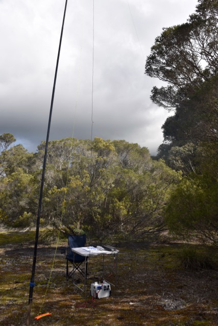
I set up in a clearing amongst the scrub and was all set and ready to go by 1.00 p.m. SA local time (a long way behind schedule). My first contact on 40m was with Geoff VK3SQ, followed by Mick VK3GGG, and then Jonathan VK6JON/7.
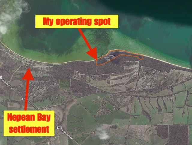
Above:- Aerial shot showing the Nepean Bay Conservation Park, about 1.5 km east of the Nepean Bay settlement. Image courtesy of Protected Planet.
It was very pleasing to see the 40m band open locally with a number of South Australian stations logged including Tom VK5EE, Col VK5HCF, Brian VK5FMID, John VK5DJ & Greg VK5ZGY mobile all in the South East, John VK5EMI in the Adelaide Hills, Adrian VK5FANA & Bevan VK5APV on the Yorke Peninsula, Michael VK5FMLO in the southern suburbs of Adelaide, David VK5PL in the Barossa Valley, Les VK5KLV at Port Augusta, Jeff VK5JK at Victor Harbour and Gary VK5ZK at Goolwa south of Adelaide. All from very diverse locations around the State, and all with great signals. This certainly has not been the case in recent months, with close in propagation on 40m at times being non existant.
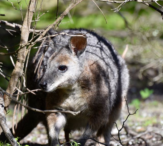
The little guy (or girl?) below, a Tammar wallaby, kept a close on me for around 15 minutes of my activation. I was very surprised. I thought that with the noise associated with setting up, and talking on the radio, he/she would have scampered off into the scrub. But no, they hung around for quite some time watching proceedings.
I worked a total of 29 stations on 40m. Contact number 44 was Cliff VK2NP, and this was 40 minutes into the activation. A total of 44 QSOs are required to qualify the park for the global section of the World Wide Flora Fauna (WWFF) program. Here in Australia, park activators and hunters tend to talk a lot more and exchange information, compared to European park activators where it is pretty much ‘5/9 thanks…..73 and 44’, and then on to the next contact. So to qualify the park in just 40 minutes was very pleasing, especially considering I was behind schedule and had 2 parks to activate that day.
I managed to accrue a further two Park to Park (P2P) contacts from Nepean Bay. They were with VK4AAC/3 in the Point Addis Marine National Park VKFF-0952 on the Great Ocean Road, and Neil VK4HNS/p who was in the Koreelah National Park VKFF-0268. I activated Point Addis myself back in November 2015 and have a clear memory of the activation as the Paramedics were called during the activation, as somebody (not me) had fallen down a nearby cliff face. For more information on that activation, please have a look at……
https://vk5pas.org/2015/12/10/point-addis-marine-national-park-vkff-0952/
After things slowed down on 40m I headed over to 20m where I worked Cliff Vk2NP, WIlliam VK2NWB, Mike VK6MB, and Colin VK3NCC/4. It was still a little too early for any DX on 20m. I did not bother trying 80m during this activation due to time constraints and also because 40m was open to VK5.
Another successful activation, with a total of 54 contacts in the log. And again many thanks to those who posted me, including Jonathan VK6JON. It certainly does help fill up the logbook.
The following stations were worked on 40m SSB:-
- VK3SQ
- VK3GGG
- VK3PMG
- VK6JON/7
- VK2PDW
- VK3BBB
- VK3UH
- VK3MRH
- VK3MCK
- VK3TKK
- VK5EE
- VK2IO
- VK5HCF
- VK3NXT
- VK5EMI
- VK2HHA
- VK5ZGY/m
- VK5FANA
- VK5FMLO
- VK2NWB
- VK4RF
- VK4HA
- VK3PAT
- VK5GJ
- VK4AAC/3 (Point Addis Marine National Park VKFF-0952)
- VK4ARW
- VK5ZK
- VK4HNS/p (Koreelah National Park VKFF-0952)
- VK4RZ
- VK3FINE
- VK5FMID
- VK5DJ
- VK5JK
- VK5PL
- VK5HS/2
- Vk5FLEX/2
- VK2KYO
- VK5KLV
- VK2JAZ
- VK3SFG
- VK3FRAB
- VK5ZGG
- VK6MB
- VK2NP
- VK3FARO
- VK5APV
- VK3FABE
- VK2FMJW
- VK7CW
- VK3NCC/4
The following stations were worked on 20m SSB:-
- VK2NP
- VK2NWB
- VK6MB
- VK3NCC/4
References.
Wikipedia, 2016, <https://en.wikipedia.org/wiki/Nepean_Bay_Conservation_Park>, viewed 17th August 2016

44 in 40 is certainly working quick!
Spectacular scenery.
Chris
VK4FR
G’day Chris,
Not bad considering it was a week day.
Cheers,
Paul,
VK5PAS.