
Last weekend (Saturday 3rd and Sunday 4th September 2016) was the 57th All Asian DX Contest, which coincided with the IARU Region 1 Field Day. So for the first time in a long time I was up late into the morning working DX.
In amongst the All Asian DX Contest contacts, I made a few contacts on the 20m band into Europe with Park activators for the World Wide Flora Fauna (WWFF) program and summit activators for the Summits on the Air (SOTA) program.
Activators worked were:-
- Andy G7SQW/p, WWFF GFF-0198
- Bernard PB7Z/p, WWFF PAFF-0061
- Chris OU7M/p, WWFF OZFF-0012
- Iratxe EA2DNO/p, SOTA summit EA/ LE-182
- Antonio EC2AG/p, SOTA summit EA1/ CT-081
- Dariusz SP9DPM/p, SOTA summit SP/ BS-026
Equipment used at home here in the shack was my Yaesu FT-2000 and 100 watts, Heil Pro4 headset, and TET Emtron TE-53, a 5 element tribander @ 16 metres on the tower in the back yard.

First up for the morning was Andy G7SQW who was operating portable from Orford Ness National Nature Reserve, GFF-0198. This was at 1446 UTC (12.16 a.m. South Australian local time). Due to antenna restrictions, Andy only operates on HF from his mobile station. Andy had a very nice 5/8 signal on the short path to me and reciprocated with a 5/9 for me from England.

Orford Ness National Nature Reserve is an internationally important coastal nature reserve which is located in Orford in Suffolk in the United Kingdom. It has a diverse range of habitats including shingle, saltmarsh, mudflat, brackish lagoons and grazing marsh. The Reserve is the largest vegetated shingle spit in Europe.


Above:- Orford Ness National Nature Reserve. Photos courtesy of https://anneguygardendesigns.files.wordpress.com
More information on Orford Ness can be found at…..
https://www.nationaltrust.org.uk/orford-ness-national-nature-reserve
Next up was Bernard PB7Z who was portable in Boswachterij Sleenerzand PAFF-0061 in the Netherlands. UTC time was 1453 (12.23 a.m. local time). My noise floor at home on 20m was strength 1, so I was receiving Bernard very well at 5/5. Bernard gave me a 5/9 signal report.

Boswachterij Sleenerzand is located near the town of Wezeperbrug, in the Drenthe region of the Netherlands. It contains quiet wood with ancient burial mounds and dolmens (a type of single-chamber megalithic tomb), which are interspersed with shifting sands, moors and fens.
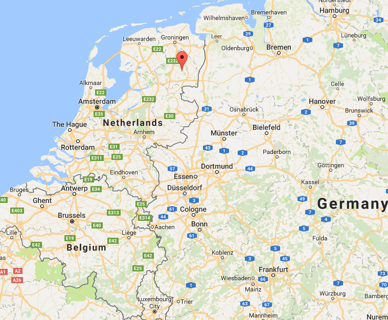 Above:- Map showing the location of Boswachterij Sleenerzand. Map courtesy of Google maps.
I then spoke with Chris who was at the mic of OU7M, the club station for the EDR Mors-Nordthy Radio Club in Denmark. Chris was portable in Feggeklit OZFF-0012 and had a very nice 5/7 signal to me, with my signal being 5/9 to Denmark. The time had now crept up to 1542 UTC (1.12 a.m. local time).
Feggeklit is a large moler embankment which previously lay as an island in the sea. It is located on the northern tip of the island of Mors. To the west Feggeklit is covered in grass, and on the steep slopes the shelves of earth slides are clearly seen. On the east side the moler is visible on the steep cliff and to the south west Skamol, the factory which processes the moler, can be seen. In 1916 Denmark’s first moler tile works ”Skarrehage Molerværk” was established on this site.
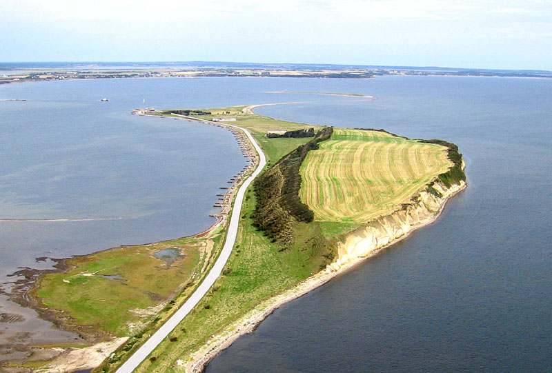
Above:-Feggeklit. Image courtesy of http://www.geospectra.net/
A Danish Myth tells that it was on Feggeklit that Hamlet murdered his wicked stepfather, King Fegge, who had his royal estate here. King Fegge had in jealous rage killed his brother, and then, married his sister-in-law, Geruth, thus becoming Hamlet’s stepfather. After Hamlet’s revenge, King Fegge was buried at the top of Feggeklit in a grave surrounded by large stones which can still be seen today.

Above:- King Fegge’s grave. Image courtesy of http://thyra2005.blogspot.com.au/
My first European SOTA activator logged for the morning was with Iratxe EA2DNO who was portable on SOTA peak Pico del Águila EA1/ LE-182. I was receiving Iratxe at 5/5 and she was receiving me on the summit in Spain at 5/7. UTC time was 1639 (1.39 a.m. local time).


Pico del Águila, meaning ‘Beak of the Eagle’ is a tabular mountain at the limits of the high plane Alcarria in the Spanish province of Guadalajara with a prominent drop of about 200 m at its northern side. The summit is 1,451 metres above sea level and is worth 6 SOTA points.
I was Iraxte’s first contact into Australia and she told me “I am very happy‘. Iraxte was kind enough to send me some photographs of her activation.


Iratxe has a WordPress site which can be found at…..
My second SOTA contact was at 1643 UTC (2.13 a.m. South Australian local time) with Antonio EC2AG who was portable on La Nieves, pico de EA1/ CT-081 in the Cantabria region of Spain. I have worked Antonio previously when he has been activating a summit for SOTA. On this occasion Antonio was running QRP 5 watts from a Yaesu FT-817 and a dipole and had a good 5/5 signal to me, with a 5/8 signal report coming back from Spain.

Above:- Map showing the location of the summit. Image courtesy of Google maps.
Las Nievos, pico de, also known as Castro de Las Nieves, is 778 metres and is worth 2 SOTA points. It is located in northern Spain north west of the city of Bilbao. It is not to be confused with the summit of the same name on the island of Gran Canaria in the Canary Islands. The summit is typically rocky and is the highest in a series of craggy elevations or forts that rise above the dividing of the Ason and Aguera point.
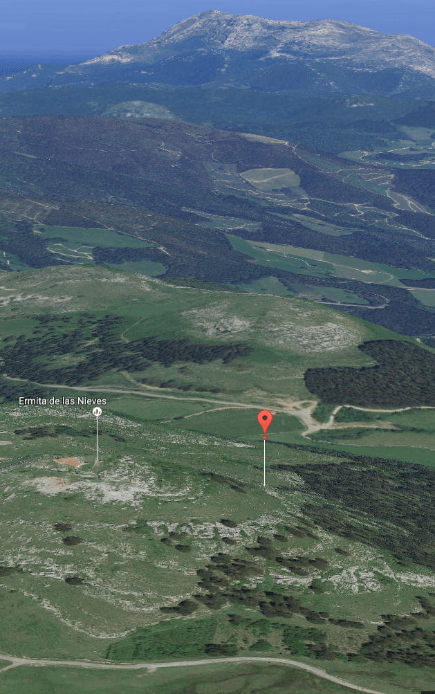
Above:- view of the summit. Courtesy of Google maps.
Every 5th August the summit is climbed by people all around the area as part of the Feast of the Virgin. On the top of the summit you can find the little chapel of the Virgen de las Nieves.


Antonio was kind enough to put a short video together of our contact. You can watch it below……..
My last portable contact for the morning was with Dariusz SP9DPM who portable on SOTA peak Chyrowa SP/ BS-026 in Poland. It was now getting pretty late for me….1646 UTC (2.16 a.m. local time).
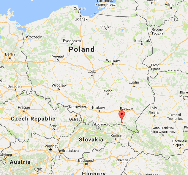
Above:- Map showing the location of Chyrowa. Map courtesy of Google maps.
The summit which is located in the Beskidy Srodkowe region of Poland is 695 metres above sea level and is worth 2 SOTA points. Dariusz was the weakest of the portable stations of the morning, being only 5/2, but very readable. Dariusz gave me a 5/1 signal report.
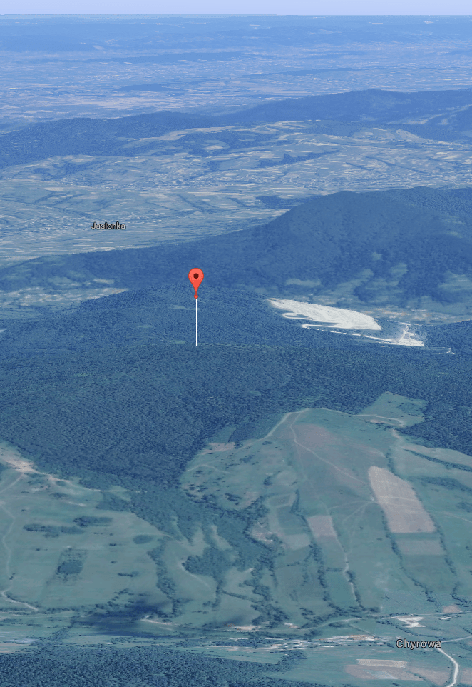
Above:- Chyrowa summit. Image courtesy of Google maps.
A fun morning, in the wee hours of the night, working both stations for the contest and 3 WWFF stations and 3 SOTA stations.
References.
Mendikat, <http://www.mendikat.net/com/mount/1610>, viewed 8th September 2016
Suffolk Tourist Guide, 2016, <http://www.suffolktouristguide.com/Orford/Orford-Ness-National-Nature-Reserve-1133.asp>, viewed 8th September 2016
Summits on the Air, 2016, <http://www.sota.org.uk/>, viewed 8th September 2016
Wikipedia, 2016, <https://da.wikipedia.org/wiki/Feggeklit>, viewed 8th September 2016

Hello Paul
A really good post. It looks like video triggered some action! Great pictures and story.
Cheers
John D
VK5BJE/VK5PF
Hi John,
I hadn’t burnt the midnight oil like that for a long time. The 20m band short path was in excellent shape. Some great signals coming in from Europe, the Middle East and sub continent.
Looking forward to Sunday.
Cheers,
Paul,
VK5PAS.
Excellent post Paul. You’ve spurred me on to attempting something similar. Hey, just imagine working European parks from Coonjie Lakes or the Simpson Desert!
Chris
VK3PAT
Hi Chris,
I’ve had some reasonable openings to Europe on the LP whilst out portable, but nothing like it was years ago. Here’s hoping that conditions are good during our trip.
Cheers,
Paul,
VK5PAS
Absolutely amazing post. The best from you yet!
Really interesting reading (not that the others aren’t) seeing parks and explanations from the north side of the world.
Thanks for the info
Regards
Chris
VK5FR (VK4FR)
Hi Chris,
Thanks for the comments. Short path conditions into Europe that night were very good. I should try to get up a bit more often at that time of the night, but I’m normally trying to get my beauty sleep!
Best 73 mate,
Paul,
VK5PAS.