Mount Gawler VK5/ SE-013

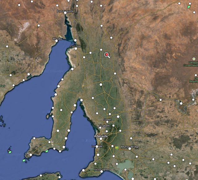
On Saturday afternoon (7th March 2015) I drove around the corner to the Mount Barker Caravan Park and met up with Tom VK5FTRG who was staying at the park for a few nights.  Tom is from Millicent in the South East of South Australia and was in the area with his family.  Tom got a ‘leave pass’ and we headed for nearby Mount Gawler VK5/ SE-013 so that Tom could undertake his very first SOTA activation.

Tom and I headed north through the Mount Lofty Ranges and into the recently bushfire devastated Sampson Flat region.  A total of 38 houses were destroyed during this fire which raged for a number of days in early January 2015 (2nd January – 9th January).  The fire blackened more than 12,500 hectares (31,000 acres).  To give you an idea on the size of the fire, have a look at the image below.  It is an overlay of the fire on the city of Adelaide.  It really puts the size of this fire into perspective.

xbxtpMg

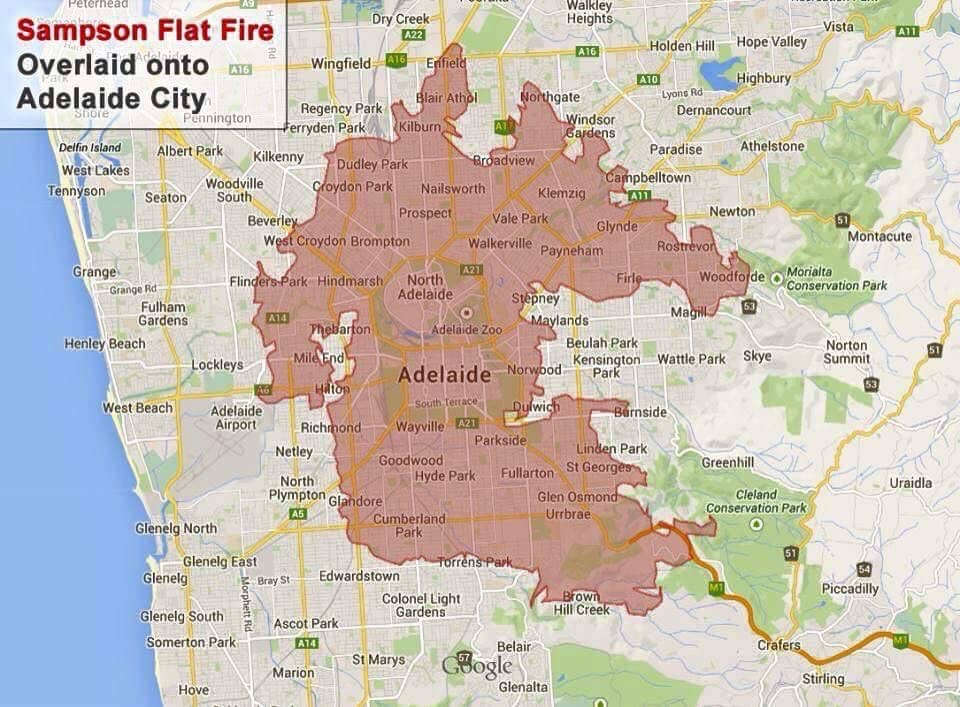
image courtesy of http://www.reddit.com/

And below is a video of the scar that this fire has left on the landscape.

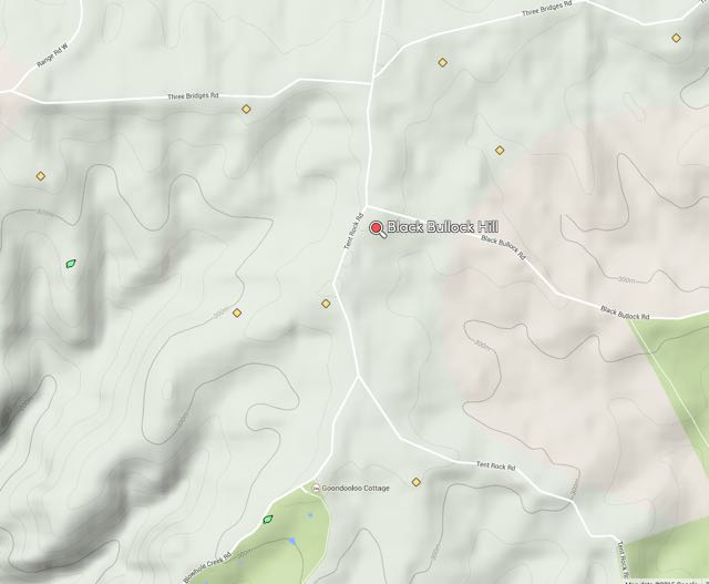
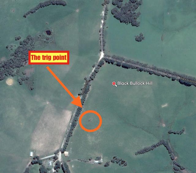
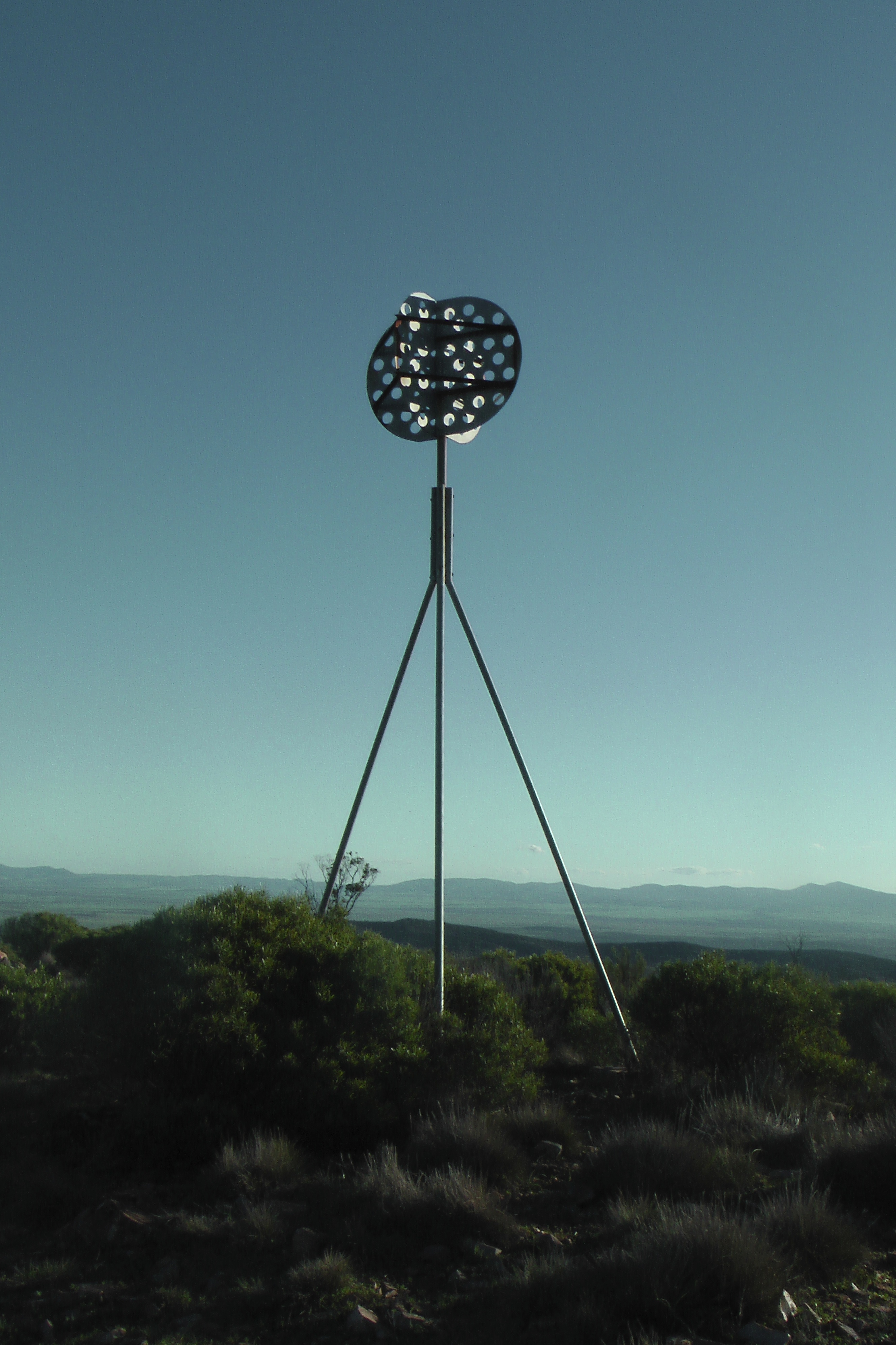
The trig point for Mount Gawler is located on land owned by Noel and Anne, who have always kindly allowed amateurs access to their property.  A few weeks after the fire I visited Noel and Anne to see how they were travelling.  Fortunately their house was spared during the fire.  At the time of my visit to Noel and Anne, I was very saddened to see the state of the area.  What was once beautiful native forest, was gone, including the beautiful Mount Gawler Forest.  But Tom and I were very pleased to see a lot of regrowth just a month or so later.  There is a long way to go, but at least many of the gum trees were starting to show regrowth, and what was completely black parched land, was now starting to show some green.

This slideshow requires JavaScript.

I had phoned Noel, earlier in the day seeking approval to operate from the trig point.  So when Tom and I arrived at Noel’s property, he had kindly left the gate open for us.  As this is an easy summit to access, Tom and I employed the ‘walk out and walk back in’ method.  We got all our gear together and then walked south down one of the gullies for a few hundred metres and then climbed back up hill again into the activation zone.

We then set up at the trig point, supporting the 7 metre squid pole in a squid pole holder with the assistance of an octopus strap.  For this activation we ran my Yaesu Ft-857d and the 40m/20m linked dipole (inverted vee).  For Tom, we obviously ran at 10 watts, and whilst I was on air I used just a little under 40 watts.  To power the radio I used a LiFePo battery.

We made ourselves comfortable on some large moss rocks which are located at the trig point and Tom started calling CQ, after I had spotted him on SOTAWatch.  It wasn’t long before Tom had his first SOTA pile up going.  And I enjoyed sitting back watching Tom in action.  The only time I picked up the mic was to get a Summit to Summit contact with Gerard VK2IO who was on top of Canoelands, VK2/ SY-001, just north of Sydney.

This slideshow requires JavaScript.

After Tom had played on 40m a bit, I put out a few quick calls on 40m and worked 7 stations in VK2, VK3, & VK4.  We then lowered the squid pole and removed the links in the dipole, and then re-erected the squid pole.  I was hoping to work a bit of DX and in particular some of the DX SOTA activators that were heading out that afternoon/evening.  I tuned around the band and soon found Barry M0IML calling CQ from Cheriton Hill, G/ SE-015, which is located in southern England.  Barry was an excellent signal, but unfortunately he was being knocked around by contesters.  That weekend was the ARRL DX Contest.  Netherless, Barry was an excellent 4/8.

I then worked Mike 2E0YYY who was portable on SOTA peak, Gun, G/ SP-013 in the Southern Pennines Region in England.  Mike also had a very good signal.  He was 5/7.  Not quite as strong as Barry, but still a very good copy.  The 20m band seemed to be in very good shape.

And my third DX Summit to Summit contact was with Tom M1EYP who was on top of The Cloud, G/ SP-015, also in the Southern Pennines Region of England.  Tom also had a good strength 7 signal, but he too was being beaten up by the contesters, so I could only give him a 4/7.

I then went to 14.302 and called CQ and my first taker was Nigel VK5NIG, ‘Mr Mount Gawler’ himself.  Nigel lives in relatively close proximity to the summit and is a regular activator of Mount Gawler.  Nigel was kind enough to spot me and this resulted in a steady flow of callers from Europe, the United Kingdom, the USA, and Japan.  All had excellent signals.  I also managed my fourth Summit to Summit contact for this activation.  This time with John VK6NU who was portable on Mount Randall, VK6/ SW-039, in the South West of Western Australia.

This slideshow requires JavaScript.

In about 30 minutes on 20m I managed a total of 38 contacts into VK2, VK5, VK6, USA, Japan, England, Spain, Italy, Switzerland, Czech Republic, Germany, Belgium, Russia, and Latvia.  I was very happy, and handed the mic back to Tom, who worked a number of stations back on 40m.  Whilst Tom was on air, I headed down and said hi to Noel.

Tom and I then enjoyed a quick snack on the summit and enjoyed a spectacular sunset, before packing up and heading off to the Bedford Hotel at Woodside where we took part in some liquid refreshment.

This slideshow requires JavaScript.

Tom worked a total of 30 stations on his very first SOTA activation.

Screenshot 2015-03-11 17.51.42

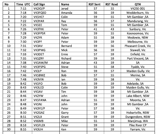
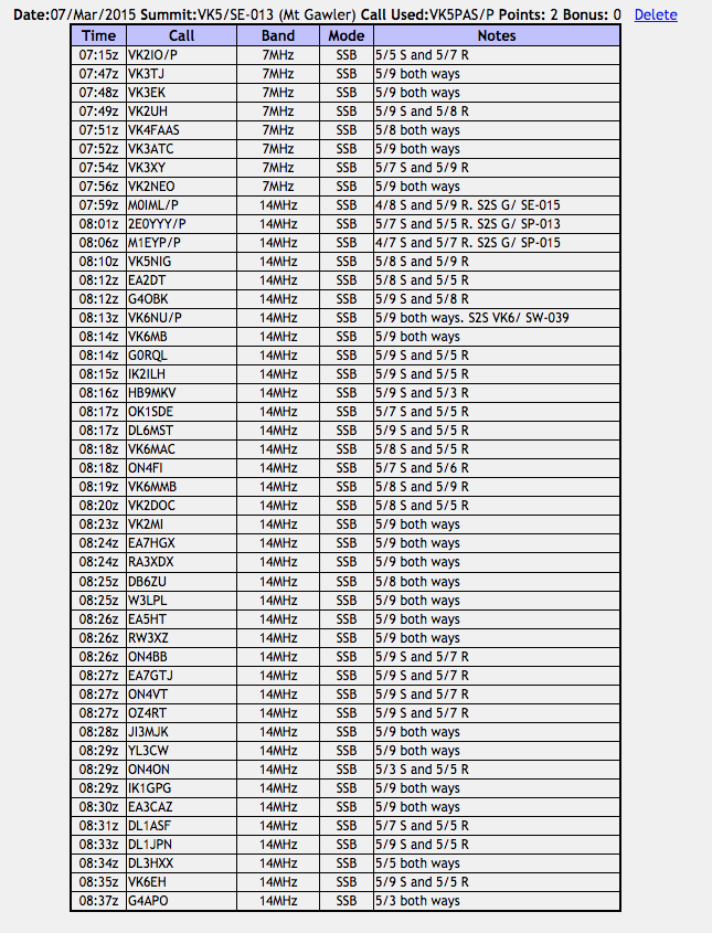
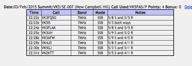
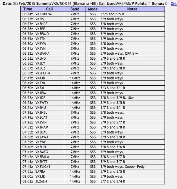
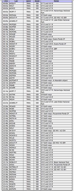
I worked the following stations:-

Screenshot 2015-03-11 17.00.16

Brownhill Range VK5/ SE-004

My first activation for Thursday 5th February 2015, was Brownhill Range, VK5/ SE-004, which is located about 27 km by road south east of Jamestown, and about 220 km north of Adelaide.

Screenshot 2015-02-07 15.43.45

map courtesy of mapcarta.com

I had planned on activating The Bluff, VK5/ NE-065, but the hike to New Campbell the day before, had really taken it out of me.  So I called the land owner for Brownhill Range, first thing on Thursday morning, and got permission from him to access the summit (owner details can be found on the SOATA database).

I made an early start from Crystal Brook, and headed west along the Goyder Highway through Narridy.  I then took the Gulnare-Spalding Road, until I reached RM Williams Way, where I turned left and headed north towards Jamestown.  I then travelled out to Bellalie East and from there to Seven Trees Road.

I stopped off at the John Ainsworth Horrocks monument just outside of Gulnare.  Horrocks was a pastoralist and explorer, who passed through the district in August 1846 on his expedition to the north west of Mount Arden.  I then travelled up into the BrownHill Range.  It was a slow drive at times, as there were numerous Western Grey kangaroos on the roads.

This slideshow requires JavaScript.

As I got higher up into the Brownhill Range, the views back to the west were excellent.  You were able to see clearly back to Jamestown and the Bundaleer Forest Reserve, and New Campbell Hill where I had activated the day before.  And there was no shortage of kangaroos in this area either.  It was slow going.

This slideshow requires JavaScript.

Brownhill Range is 755 metres above sea level and is worth 4 SOTA points.  It is located amongst the Brown Hill (Hallett 1) windfarm.

Screenshot 2015-02-07 15.40.03

image courtesy of http://www.openstreetmap.org/

Access to the summit is off Seven Trees Road.  Just down from the power plant is a set of double gates with various signsl on the gates including ‘Unauthorised access.  Trespassers will be prosecuted‘.  Please do NOT enter the property unless you have been given permission to do so.

IMGA0041_3

I travelled up the dirt road, through a number of gates, until I reached the trig point at Brownhill Range.  The trig point consists of three blue painted metal poles, about 1.5 metres in height.  I parked the car down the dirt road, and walked up the road for a short distance and then up the ridgeline to the summit.

For this activation I ran the Yaesu FT-817nd and 5 watts output.  The antenna was the SOTA Beams 40m/20m linked dipole, which I supported on the 7 metre telescopic squid pole.  I secured the squid pole to one of the trig point poles, with the assistance of some octopus straps.

It was a beautiful sunny day, but it was incredibly windy on the summit.  There is a large outcrop of rocks at the summit, and I sheltered behind a large moss rock out of the northerly winds.

Screenshot 2015-02-07 15.46.21

image courtesy of google maps.

I was on air by 2250 UTC (9.20 a.m. SA local time).  My first contact was with Tom VK5EE in Mount Gambier, followed by Adrian VK5FANA on the Yorke Peninsula who was running QRP 5 watts (5/8 sent and 5/9 received).  My next caller was Nev VK5WG at Crystal Brook, and my fourth and qualifying contact was with Peter VK3FPSR.  I worked a total of 12 stations on 40m in VK3, VK5 & VK7.  Prior to heading over to 20m I was called by a station who was very very weak, and who I was just unable to pull out of the noise.  The wind turbines were generating an S1 noise on the band, and this combined with the wind, made it very difficult to copy.  Fred Vk3DAC, who was my last contact, informed me that it was Peter Vk3PF/7 who was trying to get through to me.

I told Fred that I would QSY to 20m and try Peter on 14.310.  I quickly lowered the squid pole and removed the links and headed for 14.310.  I asked if the frequency was in use and an American voice replied, ‘yes the frequency is in use, thankyou’.  I listened a little longer and found that it was some USA stations in QSO, but I could not hear the other station.  I was amazed that at this time of the day, that my 5 watt signal was being heard in the United States.

I then found that 14.305 was clear and I started calling CQ.  My CQ call was answered by Peter VK3PF/7.  He had found me.  Peter’s signal was not all that strong, but he was very readable (5/1 both ways).  Peter was on SOTA peak, East Tower, VK7/ NE-009, in the Ben Lomond National Park.  My next contact was with David VK2WTY.  I called CQ a number of times after this, with no response.  So I decided to head back to 40m to pick up some more chasers before the UTC rollover.  It was now 2327 UTC.

This slideshow requires JavaScript.

My first contact after returning to 40m was Greg Vk5LG in the Adelaide Hills, followed by Alan VK5ZLT.  I was then called by Tom VK5EE who was mobile at the Blue Lake at Mount Gambier, and then Tony VK3CAT who was mobile at the Sandringham Yacht Club.  My final caller before the UTC rollover was John VK5FMJC at Crystal Brook.

I then took the opportunity of stretching my legs.  I came back on air just after the UTC rollover, and asked for any mobile and portable stations first.   This call was answered by Tony VK3CAT and then Tom VK5EE.  I then asked for any QRP stations and this was answered by Nev VK5WG running 5 watts from his little X1M transceiver, followed by Ian VK5IS also running 5 watts and then Adrian VK5FANA again running 5 watts.  I went on to work John VK5FMJC and Craig VK5LI who was mobile on the South Eastern Freeway neat Mount Barker.

I decided to give 20m one last go after the UTC rollover.  So down came the squid pole again, and the links on the dipole were removed.  I called CQ on 14.310 and this was answered by Peter VK4JD and then Andrew VK2MWP running QRP 2 watts.  I put out a few more CQ calls but there were no takers.

So after 90 minutes on the summit, I had a total of 28 contacts in the log.

The following stations were worked:-

Screenshot 2015-02-08 11.46.03


New Campbell Hill VK5/ SE-007

My first activation for Wednesday 4th February 2015, was New Campbell Hill, VK5/ SE-007, which is situated about 11km south of Jamestown, and about 206 km north of Adelaide.

Screenshot 2015-02-07 15.28.56

image courtesy of mapcarta.com

New Campbell Hill is 714 metres above sea level and is worth 4 SOTA points.  It is located in the ‘South East’ Region of the South Australian SOTA Association, and is located in the Bundaleer Forest Reserve.

I have activated this summit once before, with Ian VK5CZ.  For information on that activation please have a look at my previous post at…..

https://vk5pas.org/2013/07/27/new-campbell-hill-vk5-se-007/

Screenshot 2015-02-07 15.28.06

New Campbell Hill is part of the Campbell Range.  It is not to be confused with Campbell Hill which is located further to the south.

This slideshow requires JavaScript.

I had an early start from Crystal Brook and I headed north along RM Williams Way towards Jamestown.  I turned left onto Bundaleer Gardens Road, and stopped briefly to have a look at the memorial for Pioneers of the Bundaleer District.  I continued on up Bundaleer Gardens Road, and parked the car at Neindorf Road, where I packed my backpack, and commenced the @5 km walk to the summit.

This slideshow requires JavaScript.

Bundaleer is regarded as the birthplace of forestry in Australia.  It covers an area of about 3,200 hectares.  It is still home to Curnow’s Hut, the original residence built for the district’s first nursery worker, William Curnow (see below).  The name Bundaleer is derived from an aboriginal word, meaning ‘stony place’.

Screenshot 2015-02-08 16.51.54

Map courtesy of Forestry SA.

Bundaleer Forest was originally part of the Bundaleer Run, which was a vast pastoral station established in 1844 by John Bristow Hughes (b. 1871 – d. 1881).  Hughes was born in England in 1817 and arrived in South Australia in 1841 aboard the Porter, following his arrival in Tasmania in 1840.  He was married in 1847 in Adelaide, and established Bundaleer shortly after arriving in South Australia, with sheep he had brought across from Tasmania.

Screenshot 2015-02-08 16.36.21

Above: J.B. Hughes.  Image courtesy of http://www.samemory.sa.gov.au

In 1875, a Forest Board was appointed by the South Australian Government, and Forest Reserves were created, mainly in the South East.  However, some sections were created in the north of South Australia.  In c. 1876 the Forest Board commenced work at Bundaleer Springs when a nurseryman, William Curnow was sent to establish a nursery and prepare 400 hectares for lanting.   Curnow commenced planting asmanian Blue gums, local Red gums and Sugar Gums adjacent to the Jamestown to Spalding Road (RM Williams Way).

I followed the Bore Track up to the summit.  The walk starts off very easy, but don’t get too excited.  Worse is to come.  The initial walk took me passed beautiful pine forest, along a very easy access track.  There were quite a few Western Grey kangaroos out, enjoying the morning sunshine.  But unlike last time I activated the summit, I did not see any native deer.

The Bundaleer Forest Reserve was devastated by fire in early 2013.  Around 23,000 hectares of forest and scrubland were destroyed.  Over 30 % of the pine plantations were wiped out.  Leith Cooper, who is a local farmer stated: ‘It was one of the worst fires I’ve ever seen, there were reports that the flames were 100 feet above 50 foot pine trees, it was pretty intense’.  For more information on the fire, including some audio, please have a look at…..

http://www.abc.net.au/news/2013-05-14/charred-bundaleer-forest/4687770

There are some excellent views once you reach the top of the summit.  And the amazing dry stone walls which follow the ridgeline, are really quite a sight.  They are mentioned in a book called ‘those dry-stone walls’ written by Bruce Munday, which I have a copy of.  Many of these old walls were created by Patrick O’Grady (1838-1906), who was a ‘waller’ on Bundaleer Station.  Munday is remembered as bing ‘a little old man with long ringlets who always wore green ribbon in his coat’.  He is buried with his wife Annie at the Jamestown cemetery.  Local photographer, Mary-Anne Young made the following comment: ‘For someone who created such magnificent stone work, it is a disapointing grave’.

This was not one of my most memorable SOTA activations.  After setting up the linked dipole, I discovered that I had a very high VSWR.  Numerous checks were undertaken on the antenna, and this revealed that the likely source of the problem was the coax crimping on the BNC connector.  Not much I could do about it, as I didn’t have the required tools, and I had left the spare antennas back in the car.

Anyway I pressed on and called CQ on 7.090.  My first contact was with Amanda VK3FQSO (5/8 sent and 5/5 received), followed by Ian VK5IS (5/3 both ways), Bob Vk5FLAK (5/8 sent and 5/5 received), and my fourth and qualifying contact was with VK3UH (5/9 sent and 5/2 received).

Much to my surprise I was called by VK4JD who have me a 4/1 signal report, and Paul VK2KTT who also gave me a 4/1 signal report.

This slideshow requires JavaScript.

So felling very frustrated, I packed the gear up and headed down the hill back to the car.  Just 8 contacts in the log, but thankfully the summit had been qualified.

I think the next time I active this summit I will try parking near Curnows Hut and walking north along the Heysen Trail to the summit.  Easier?  I’m not sure.  At the current time this section of the forest is closed due to restoration work after the 2013 bushfire.

After the activation I headed in to Jamestown, where I went to the Jamestown bakery for a pastie.  Jamestown is a beautiful little town and certainly worth a look.  There is an interpretice centre for RM Williams, who was an Australian bushman and entrepreneur who rose from a swagman, to a millionaire.  Fore more information on RM Williams, please have a look at the following…..

http://en.wikipedia.org/wiki/R._M._Williams

This slideshow requires JavaScript.

For more information on Jamestown, have a look at the following…..

http://www.visitjamestown.com.au/

The following stations were worked:-

Screenshot 2015-02-08 11.34.02


References.

ABC, 2015, <http://www.abc.net.au/news/2013-05-14/charred-bundaleer-forest/4687770&gt;, viewed 8th February 2015.

Government of South Australia, Forestry SA, 2015, Bundaleer Visitor Information brochure, <https://www.forestry.sa.gov.au/Portals/0/Publications/InfoLeaflets/Bundaleer%20Forest.pdf&gt;, viewed 8th February 2015

Government of South Australia, State Libarary, 2015, <http://www.samemory.sa.gov.au/site/page.cfm?u=77&c=5232&gt;, viewed 8th February 2015

Munday; B, 2012, ‘those dry-stone walls’, Wakefield Press.

Illawarra Hill VK5/ SE-014

My third and final activation for Tuesday 3rd February, 2015, was Illawarra Hill, VK5/ SE-014, which is located about 11 km by road from the town of Snowtown, and about 155 km north of Adelaide.

Screenshot 2015-02-07 15.24.18

image courtesy of mapcarta.com

Illawarra Hill is 434 metres above sea level, and is worth 1 SOTA point.  It is located in the Barunga Range, west of Snowtown.  The town of Snowtown became infamously known for the Snowtown murders.  This is rather sad, because the vast majority of the murders were not even committed in the town.  However the bodies of many of the victims were stored in barrels in an old bank in the main street.  Snowtown is located in the wheat belt area of the Mid North of South Australia, and has a population of about 500 people.

In 2008, a monument called ‘The Big Blade’ in the form of a 44 metre wind turbine was installed in Snowtown.  There are a number of interpretive signs there, telling you all about the nearby Snowtown wind farm which is situated on the Hummock and Barunga Ranges to the west of the town.  It is well worth a look.

This slideshow requires JavaScript.

The first stage of the Snowtown wind farm was commissioned in September, 2008 with 47 Suzlon S88 2.1 MW turbines.  In 2011, an additional prototype Suzlon S95 2.1 MW turbine was installed and commissioned.  Since 2008, Stage 1 of the Snowtown wind farm has provided reliable electricity into the South Australian electricity network delivering a long term capacity factor of 43%, one of the highest wind farm outputs in Australia.  Final approvals for Stage 2 of the Snowtown Wind Farm were secured in August 2012 to install a further 90 Siemens 3.0 MW turbines, with a combination of 101 metre and 108 metre blade diameters, with an output of up to 270 MW.  With the completion of Snowtown 2, the total output of the combined Snowtown wind farm will be 370.8 MW, making it the biggest single wind farm in South Australia.  Over 230,000 homes can be powered by the Snowtown Wind Farm.

After leaving Snowtown, I headed west along Shadwells Gap Road.  About 5 km along this road, you will reach a gate on your right.  There are a number of signs here including ‘Snowtown Wind Farm Stage II” and ‘Private Property.  Trustpower Windfarm.  Tresspassers Prosecuted’.

This slideshow requires JavaScript.

The summit is located on private property and is situated amongst the windfarm.  I had spoken with the landowner a few days prior, and had sought approval to access the summit.  PLEASE do NOT access the summit without the approval of the land owner.

Screenshot 2015-02-07 15.25.05

image courtesy of http://www.openstreetmap.org/

I drove along the dirt road after entering via the gate and headed north up towards the telecommunications tower and the trig point.  It was a very warm afternoon, so I set up underneath a small sheoak tree and an adjacent dead tree stump.  It was not the most comfortable of ‘shacks’, but it did provide a little bit of shelter from the very hot afternoon sun.  As you would expect, it was extremely windy on the top of the summit.  There aren’t too many other options on a hot day on this summit.  The only over cover are the two rainwater tanks a little closer to the trig point.

For this activation, I used the Yaesu FT-857d and ran 20 watts.  My antenna was the SOTA Beams 40m/20m linked dipole, which I supported on a 7 metre telescopic squid pole.  I secured the squid pole to the squid pole holder with an octopus strap.  Because it was so windy, I used the guying rope which I tied off to a fallen tree limb.

My first contact was with Peter VK3TKK who was mobile, followed by Ian VK5IS at Beetaloo Valley, Col VK5HCF in Mount Gambier, and then Tom VK5EE, also in Mount Gambier. Signals were very good, and there was no man made noise on the summit.

After working 13 stations on 40m, I headed up to 20m hoping to work some DX.  But I was to be sadly disapointed.  I did work a total of 7 Australian stations in VK1, VK2, VK3, VK4, and VK6, but did not have a single European caller.  I have mentioned it before, but I guess we take distances for granted here in Australia.  My contact with Peter VK4JD was over a distance of about 1,900 km.  My contact with John Vk6NU was over a distance of about 2,500 km.  In some parts of the world, this is a DX contact.  But here in Australia we call it a ‘local’ QSO.

I moved back to 40m and placed another CQ call on 7.090, and this was answered by Ray VK3NBL, and then Tony VK3CAT, followed by Ian VK3VIN, and then Andrew VK1NAM.  All had excellent signals.  I went on to work a further 8 VK stations.

This slideshow requires JavaScript.

I decided to try my luck again on 20m, so I again lowered the squid pole and removed the links and tuned across the 20m band.  But sadly, the European signals I was hearing, were low down.  I headed up to 14.156 where I made contact with John EA7BA in Almeria in Spain, Brian VK2JE, and Brian ZL2ASH in Wellington in New Zealand.

I had a total of 35 contacts in the log.  It was time to pack up and get back on the road and head back to Crystal Brook, about 60 km away.

Upon arriving in Crystal Brook I headed to the Crystal Brook Hotel, where I enjoyed a very nice Schnitzel, chips and salad, and a few cold Bundies and coke.  I then returned to the Crystal Brook Caravan Park, where I enjoyed the sunset and the almost full moon.

This slideshow requires JavaScript.

I highly recommend the Crystal Brook Caravan Park.  The caretaker was very friendly and the cabin which I stayed in was very clean & tidy.

This slideshow requires JavaScript.

The following stations were worked on Illawarra Hill:-

Screenshot 2015-02-08 11.27.56


References.

Wikipedia, 2015, <http://en.wikipedia.org/wiki/Snowtown,_South_Australia&gt;, viewed 8th February 2015.


Bumbunga Hill VK5/ SE-015

My second activation for Tuesday 3rd February, 2015, was Bumbunga Hill, VK5/ SE-015, which is located about 8 km by road from the little town of Lochiel, and about 141 km north of Adelaide.

Screenshot 2015-02-07 15.20.08

Image courtesy of mapcarta.com

Bumbunga Hill is 413 metres ASL and is worth just 1 SOTA point.  The summit is located on private property.  I had sought permission from the land owner a few days before (contact details can be found on the SOTA database).  Access to the summit is via Landslide Road.

If you are on the A1, take Robert Street at the northern end of the town of Lochiel and travel west.  You will then reach Landslide Road.  Turn right here and travel a few km up Landslide Road.   On your right, you will see some double gates which have numerous locks on them.  Alongside, on both the left and right of these gates, are some ‘cocky’s gates’.  This is where you enter the private property.  PLEASE ensure you have permission prior to entry.  And please close the gates behind you.  You will know that you are in the right spot, because there is a large shed on the right of the main dirt track behind the gates, and a house ruin on the left of the track.

But for me, after leaving South Hummocks, I continued north along Pump Station Road, V. Taylors Road, and then Lochiel Road, until I reached Landslide Road.  It saved me having to travel back to the bitumen.

This slideshow requires JavaScript.

The main double gates were locked.  There is a plethora of padlocks on the gates.  Each stakeholder of the communications tower at the top has a padlock on the gates.  I entered via the ‘cocky’s gate’ on the left, which consisted of a rusty star dropper and some mesh.  The links were quite rusty, and in the end one of them snapped on me.

IMGA0100

I followed the fenceline up passed the dam and stopped for a short time to have a chat to one of the farmhands.  He then pointed out a gate on the other side of the dam, which in turn leads to the track which takes you up to the summit.  Don’t attempt this track in a conventional vehicle.  You will make it to the ridgeline above the shed and ruin, but from there the track is definitely 4WD territory.  It is very rough with lots of washaways and large rocks.

Once you have negotiated the rockiest part of the track, you will reach another gate.  Today, it was closed.  Please leave all of the gates as you find them.  Even before you reach the very top of Bumbunga Hill, you will be rewarded with some excellent views of the surrounding countryside, the little town of Lochiel, and Bumbunga Lake.

This slideshow requires JavaScript.

The dirt track from the top gate to the summit is good from here.  Follow the fenceline until you reach another gate.  On the other side of this gate you will find the telecommunications tower, the Lochiel repeater, and what is left of the trig point.  When I first activated this summit back in April, 2013, the trig point was lying on its side on the ground.  Nowadays it has gone, and the trig is marked with three upright poles, which are painted blue.  They make an excellent anchor point for a squid pole.

Screenshot 2015-02-07 15.22.22

image courtesy of http://www.openstreetmap.org/

The town of Lochiel lies below the summit, just to the south east.  Governor Fergusson named it Lochiel after Lochiel Forest, near Inverness in Scotland.  Lochiel is also the name of one of the titles of the chief of the Cameron Clan, while the Scottish ‘Lochiel’ comes from the Gaelic ial – ‘gleam of sunshine’.  Salt has been mined at nearby Bumbunga Lake since 1912.  A coal mine was also in operation, a few km east of the lake, between the 1980s and 1990s.

The earliest reference to Lake Bumbunga is to be found in a little book entitled ‘Reminicences of a Sojourn in South Australia’ by ‘A Squatter’, published in 1849.  The author talks about a chance meeting with two tired travellers at a camp fire, at the head of St Vincents Gulf, not far from the Lake.  One of the travellers told the squatter that he had come from Lake ‘Bambunga’, which he claimed to have discovered.  The traveller went on to say, ‘The name is one that the natives formerly gave it and, as being the discoverer and licenced occupier, I conceived I had a right to apply what name I pleased to it’.   It appears that name has since elapsed over time into Bumbunga.

According to anthropologist Norman Tindale, the name was derived from the local Parnpangka aboriginal people and means ‘rain water lake’.  However, in 1967, H.M. Cooper of the SA Museum stated that the word Bumbunga meant ‘by, near or at the lake’.

The squatter goes on to say “the ‘Bambunga country’ was carrying 10,000 sheep and eighteen perpetural springs”.  The area was part of Hummocks Run.  Bumbunga was one of two substations for this very large sheep and cattle station, which by 1864 had 70,000 sheep, 200 bullocks and horses.  The Bumbunga station consisted of a pine house, store, men’s kitchen, sleeping rooms, woolshed, yards, sweating shed, fenced paddocks, three wells troughs, and one pump.

I found the following from the Adelaide Observer, dated Saturday 1st October 1864.

Screenshot 2015-02-07 22.15.10

And also the following from the Northern Argus, Clare, dated Friday the 13th October, 1871.

Screenshot 2015-02-07 22.30.21

I set up at the trig point, and secured the 7 metre squid pole to one of the trig point poles, with two octopus straps.  It was a warm day, but it was also incredibly windy.  And the flies were out in force.  The Aerogard did not seem to be having any affect.  For this activation I ran the Yaesu FT-817 and 5 watts output.

Before calling CQ, I tuned across the 40m band and found  Ian VK3TCX on 7.095 calling CQ from SOTA summit, Mount Cann, VK3/ VG-133, which is located in the East Gippsland area of Victoria.  Ian’s signal was pretty weak, but very readable (5/2).  So I waited a little while for the multitude of callers to slow down, and then gave Ian a call.  We exchanged 5/2 signal reports with each other.  A good start to the activation at Bumbunga Hill….a Summit to Summit contact.

I then went down to 7.090 and put out a CQ call and this was answered by Larry VK5LY in The Riverland, followed by John VK2YW in Wagga Wagga, and Rob VK3EK.  As it was a weekday, I had a steady flow of callers, but certainly not the ‘pile ups’ that can be expected on weekends.

Whilst on Bumbunga Hill, I worked a few QRP stations.  They included Adrian VK5FANA, who was running just 5 watts from the Yorke Peninsula (5/8 sent and 5/9 received).  Thanks to Adrian for spotting me.  Also, Gary VK5FGAZ, running 5 watts, from north of Adelaide (5/8 sent and 5/9 received).

And I also worked a few mobile stations.  The first being Tom VK5EE who was mobile in Mount Gambier, followed by Brian VK3YFL mobile near Kaniva in Western Victoria.

This slideshow requires JavaScript.

After working a total of 16 stations on 40m I lowered the squid pole and removed the links and headed up to 14.310 where I put out a CQ call.  This was immediately answered by Greg VK5LG in the Adelaide Hills, who had been my last contact on 40m and had followed me up here to 20m.  I worked a total of 6 stations on 20m SSB, including another Summit to Summit.  This time with Peter VK3PF/7 who was on Macgregor Peak, VK7/ SC-018, which is also located within the Tasman National Park (5/4 sent and 5/7 received).

I then returned to 40m for a short time where I worked another 5 stations in VK3 & VK5.

Once I got down off the summit, I drove down to Lochiel and found a shady spot under a tree alongside of Bumbunga Lake and had some morning tea.  I then jumped back into the 4WD, and headed north to Crystal Brook.

This slideshow requires JavaScript.

The following stations were worked:-

Screenshot 2015-02-08 11.10.18


References.

Cockburn, S, 1908, ‘South Australia.  What’s in a Name?’

Government of South Australia, State Library, 2015,<http://www.slsa.sa.gov.au/manning/pn/b/b30.htm&gt;, viewed 7th February 2015

Wikipedia, 2015, <http://en.wikipedia.org/wiki/Lake_Bumbunga&gt;, viewed 7th February 2015

Wikipedia, 2015, <http://en.wikipedia.org/wiki/Lochiel,_South_Australia&gt;, viewed 8th February 2015

South Hummocks VK5/ SE-017

Early on Tuesday morning (3rd February 2015) I headed north towards Crystal Brook, which is about 200 km north of Adelaide.  I had booked in to stay for 3 nights at the Crystal Brook Caravan Park.  My main reason for heading there was to meet up with a number of the amateurs from the Mid North of South Australia, and deliver a presentation on the VK5 National and Conservation Parks Award and also the World Wide Fora Fauna (WWFF) program.  Along the way on the first day, I had planned to activate three summits for the Summits on the Air (SOTA) program.  The first was South Hummocks, VK5/ SE-017, which is located about 29 km by road from Port Wakefield, and about 126 km north of Adelaide.

Screenshot 2015-02-07 15.12.04

image courtesy of mapcarta.com

South Hummocks is 330 metres above sea level and is worth 1 SOTA point.  The summit is located on private property, so a few days before heading there, I sought approval from the land owner, Colwyn Millard (his contact details can be found in the SOTA database).  The summit is clearly visible as you travel towards Port Wakefield along the Port Wakefield Road (A1).  It may not be the tallest of summits, but it is certainly very prominent after travelling the vast flat plains north of Adelaide, as you head towards Port Wakefield.

This was to be my second activation of South Hummocks.  I first activated the hill back in April, 2013 with Andy VK5AKH.  In fact, South Hummocks was one of my first ever SOTA activations.  For more information on that activation, please have a look at my previous post at…..

https://vk5pas.org/2013/04/14/south-hummocks/

This slideshow requires JavaScript.

The summit is located in the Hummocks Range, which is a range of hills which commence just north of the apex of Gulf St Vincent, near the little settlements of South Hummocks and Kulpara.  The Hummocks Range stretches to its northern end where it merges with the Barunga Range at Barunga Gap, about 10 km west of Snowtown.  The Hummocks and Barunga Ranges form part of a number of low lying ridgelines occurring in the Mid North region of South Australia.

This southern part of the Hummocks Range has not yet been impacted by windfarms.  The Hummocks Range is the primary source of water catchment for Lake Bumbunga, which is located a little further north, near the town of Lochiel.  The primary land use for the surrounding area is stock grazing and cereal cropping.

Although much of the surrounding area has been cleared for grazing and cereal production, there are still patches of scrub to be found.  In fact, quite a bit of remnant scrub remains on the summit itself.  A variety of native animals, birds, and reptiles can be found including Western grey kangaroos, the Flinders Worm lizard, and the Peregrine Falcon.  Whilst I was on the summit I observed a number of Euros, but they were just too quick to catch on camera.  I also observed a Wedge Tailed eagle sailing along the ridgeline, obviously in search of breakfast.

Screenshot 2015-02-07 15.16.16

image courtesy of http://www.openstreetmap.org/

The South Hummocks region has a rich agricultural history, and at one stage had a large population.  Some of the early pastoralists included Charles Burney Young and Edmund Bowman.  South Hummocks had a railway station, and even had its own football team back in the early 20th century.

Screenshot 2015-02-07 21.15.35

above:- Charles Burney Young.  Image courtesy of Pastoral Pioneers of South Australia

Screenshot 2015-02-07 21.14.25

above:-Edmund Bowman.  Image courtesy of Pastoral Pioneers of South Australia

I found the following from the South Australian Weekly Chronicle, dated the 9th April, 1887.

Screenshot 2015-02-07 21.22.46

image courtesy of trove.nla.gov.au

And this one from the South Australian Weekly Chronicle, dated the 2nd day of July 1887.

Screenshot 2015-02-07 21.26.12

How do you get to the summit?  If you are travelling north, enter Port Wakefield, and then after leaving the town, take the turnoff to the Yorke Peninsula just out of town.  This is the Copper Coast Highway.  Continue along the Copper Coast Highway for a number of km, and then turn right onto Balaklava Road.  A short distance up you will reach Pump Station Road.  Turn left here and continue for a number of km north on Pump Station Road.  Before you reach Millards Road (on your left), you will see some double gates on your right.  The gate has ‘Private Sanctuary’ written on it.  This is where you enter the private property.  PLEASE ensure you have permission prior to entry.  And please close the gates behind you if you find them closed.

I followed the fenceline up through the paddock.  The first part of the drive through the paddock can be undertaken using a conventional vehicle.  But you will then reach a sign which says ‘Engaged 4WD only’.  Please take notice of the sign, and engage 4WD if you have it.  You will never make it up the track if you don’t, as it becomes very rocky and slippery.  If you don’t have a 4WD, leave your car here at this point and walk the rest of the way.  It is about a 20 minute walk up the track from here to the trig point.  I continued on up the track and went all the way to the communications tower at the end of the track, where I had a photo stop.  I then drove back down the track and parked the 4WD, and then walked uphill again, over the fenceline and into the scrub to the trig point.

This slideshow requires JavaScript.

You will need to keep a good eye out for the trig point for South Hummocks, as it is not easy to spot.  As you travel north along the track, keep an eye out for a star dropper which is painted blue at the top.  There is also a piece of yellow tape attached to the top strand of barbed wire on the fence at this point, and another piece of yellow tape tied around a nearby tree.

The original trig is no longer at the site.  It was there when I last activated the summit in April 2013, but sadly, as is the case with many trigs around South Australia, it is no longer in existence.  All that remains of the trig are some of the pieces of rusty metal, lying amongst the scrub.  There are two blue poles at the trig site.  There is also a small pile of rocks, no doubt attributed to visitors to the summit.

IMGA0036

I ran the Yaesu FT-817 and 5 watts for this activation, and the SOTA Beams 40m/20m linked dipole.  By the time I had set up the gear, I was just 20 minutes later than my estimated time of activation of 2200 hours UTC (8.30 a.m.).  I tuned to 7.090, which was my nominated starting point, and called CQ and this was immediately answered by Ian VK5IS in Beetaloo Valley (5/9 both ways), then Jim VK5KOB in Elizabeth (5/9 both ways), and then Geoff VK5HEL in Murray Bridge (5/9 both ways).  My fourth and qualifying contact for the summit, was with John VK5FMJC in Crystal Brook (5/9 sent and 5/8 received).  Propagation locally seemed to be very good.

My next contact, was my first interstate contact for the summit.  It was Fred VK3DAC, north east of Melbourne, who was a good 5/9 signal to South Hummocks.  Fred reciprocated with a 5/2 signal report for me.  I went on to work 16 stations on 40m SSB before heading off to 20m.  Those stations worked were in VK3, VK5, VK6 & VK7.   It was very pleasing to get Mike VK6MB from Perth in the log on 40m (5/7 sent and 4/2 received).  And also John VK2YW in Wagga Wagga (5/8 sent and 5/5 received).  I often struggle with Mike and John on 40m at this time of the day.  But this day we made it easily.  And to top it off, I made contact with Peter VK3PF/7, on holidays down in Tasmania.  Peter was on his way to activate a summit.  Peter was very weak, 5/1, but very readable, due to the non existant man made noise floor on the summit.

I then lowered the squid pole and removed the links in the 40m/20m linked dipole, and called CQ on 14.310.  Larry VK5LY was kind enough to spot me on SOTA Watch before I QSY’d, so by the time I had got to 20m, there were a few stations there waiting for me.  It highlights the benefit of spotting!  My first contact on 20m was with Mike VK6MB.  He was the same signal strength here on 20m (5/7) as he was on the 40m band.  My signal report had also remained the same (4/2), but Mike reported that the 20m band was a lot quieter for him than 40m.  My next caller was Peter VK4JD in Jimboomba with a very strong 5/9 signal, and then to my surprise, John VK5BJE in the Adelaide Hills, who was 5/9.  John gave me a 5/8-9 signal report.  This contact surprised me a bit, as we were only @ 120 km apart, and normally this is far too close for good propagation on 20m.

This slideshow requires JavaScript.

After working 7 stations on 20m SSB in VK2, VK4, VK5, & VK6, I moved back to 40m where I put out a few final CQ calls.  My first taker upon returning to 40m was Rex VK7MO, with a very nice 5/9 signal from near Hobart in Tasmania.  This was followed by Mal VK5MJ in The Riverland, Phil VK3BHR and finally Adrian VK5FANA on the lower Yorke Peninsula, running QRP 5 watts (5/9 both ways).

After activating the summit for about 45 minutes, I had a total of 27 contacts in the log on 40m SSB and 20m SSB.  It was time to pack up and head off to my next summit, Bumbunga Hill.

Although South Hummocks is worth just 1 SOTA point, for me the summit highlights the fun that SOTA is.  South Hummocks is an easy summit to access, and despite being only 330m ASL, it offers sensational views of the surrounding countryside.  The wildlife is also well worth the trip.

The following stations were worked:-

Screenshot 2015-02-07 18.37.25


References.

Aldersley, D, 1923, ‘Pastoral Pioneers of South Australia’.

Wikipedia, 2015, <http://en.wikipedia.org/wiki/Hummocks_Range&gt;, viewed 7th February 2015

Wind Prospect Pty Ltd, 2003, ‘Environmental Statement, Proposed Barunga Wind Farm Hummocks & Barunga Ranges’.

Black Bullock Hill VK5/ SE-016

For Australia Day (Monday 26th January 2015) I headed down to the Fleurieu Peninsula, south of Adelaide, where I activated Black Bullock Hill, VK5/ SE-016 as part of the Summits on the Air (SOTA) program.  The summit is the highest point of the Fleurieu Peninusla, and is located near the little town of Delamere, about 100 km south of Adelaide.

Screenshot 2015-01-27 20.54.23

Map courtesy of mapcarta.com

This is not a ‘traditional’ summit, in that it is not a hill or mountain.  But it is the highest point on the Fleurieu Peninusla, and qualifies for the SOTA program under the 150 prominence rule.

I have activated the summit two times previously.  In fact it was my first ever SOTA activation, way back in March, 2013.  For more information on those activations, please have a look at my previous posts…..

https://vk5pas.wordpress.com/2013/03/03/vk5se-034/

https://vk5pas.wordpress.com/2013/10/08/vk5-se-016-and-the-1-year-vk5-sota-anniversary/

Screenshot 2015-01-27 20.53.44

map courtesy of mapcarta.com

It is a beautiful drive from my home in the Adelaide Hills, down to the summit.  I got up early though to miserable weather.  It was raining, and I was worried that I might have to cancel the activation.  This was weather that we are certainly not used to on Australia Day in the middle of Summer.

IMGA0001

Above- the view from my front yard, first thing in the morning.  Not good!

Anyway I packed the car and headed off through Echunga, on to Meadows, and then on to Willunga via Brookman Road, travelling passed the beautiful pine forests.  They were still packing up the marquees at the top of Willunga Hill where they held the King of the Mountain for the Tour Down Under cycling event.  From there I cut across to Myponga through Pages Flat, and then travelled south until I reached the towns of Yankalilla and Normanville.  I then travelled south along the Main South Road, following the coastline and the amazing views, until heading back inland to Second Valley.  This is truly, very beautiful countryside.  From there I reached the little town of Delamere, where I turned left onto Range Road and headed east.  Once I reached Three Bridges Road I turned right and headed south until I reached the intersection of Three Bridges Road, Dog Trap Road, and Tent Rock Road.  The summit is located on the south eastern corner of this intersection.  I encountered numerous kangaroos along the way, so it was slow going.  This resulted in me, having to pull over and amend my alert on SOTAWatch, delaying the activation by one hour.

This slideshow requires JavaScript.

As I had sought approval from the land owner prior to heading to the summit, I parked my car down Dog Trap Road, and walked up to the summit, and with some care, climbed the electric fence and approached the trig point, which is just a short distance inside the fenceline.  It is hidden a little by the thick scrub on the eastern side of the road.  It was here at the trig point, that I set up my equipment.  For this activation I used my Yaesu FT-817nd, 5 watts output power, and the 40m/20m linked dipole supported on a 7 metre telescopic squid pole.  I powered the radio with a 12 volt 4 ah SLAB battery.  I secured the squid pole to a squid pole holder, with the assistance of an octopus strap.  And for this activation, I used the special AX prefix to celebrate Australia Day.

No creature comforts here at the summit.  I sat alongside the trig point, with my back propped up against the trig.  At home, amongst the ants and the other creepy crawlies.  And the weather was miserable.  Although it had stopped raining, it was freezing cold.  The Southern Ocean was in sight, and the breeze off there was very chilly.  The nearest land to the south is Antarctica, so no wonder it is a cold spot.  Unfortunately, the issue of no rain was not to last.  And as I found out during the activation, there were a few times I had to seek shelter underneath my bothy bag.

Screenshot 2015-01-27 20.54.12

Image courtesy of mapcarta.com

Prior to calling CQ I had a quick look around the band and soon found Col VK5HCF calling CQ from the Piccanninie Ponds Conservation Park in the South East of South Australia.  I was aware that Col and Tom VK5EE were going to venture out that morning for the activation, and I was hoping to get them in the log for the VK5 National and Conservation Parks Award.  Only trouble was, Col was virtually unreadable.  He was so low down and faint, that I didn’t even bother calling because I didn’t think I would get through.  This was very disapointing, as I was hoping to work Col whilst he was in the Conservation Park.  But things were to only get worse.

I then found John VK5BJE, calling CQ from the Belair National Park in the Adelaide Hills.  John was the second VK5 Parks activator that I knew as going to be out and about that morning.  And he too was so low down, that again I didn’t bother even trying to make the contact.  In fact, John’s signal was even lower than Col’s.  This was not a good start to the morning’s proceedings.

So with a fair degree of disapointment, I found 7.105 to be clear and put out a CQ call.  This was immediately answered by Amanda VK3FQSO with a nice strong 5/8 signal from Wedderburn.  And this was followed by Julie VK3FOWL, also 5/8, and then Bandor AX3FKSA who was also 5/8.  Three Foundation call,s running 10 watts, with excellent signals.  It appeared that the further afield stations were coming in well.  But there was no close in propagation.  My fourth qualifying contact for the summit, was with John, AX2YW in Wagga Wagga who was a very strong 5/9.

My 7th contact in the log, was Mike, VK6MB in Perth, Western Australia, who was a very nice 5/8 signal, some 2,700 km away.  Mike gave me a 4/4 signal report from my 5 watts.  Not great, but we still made the contact on 40m, which is not always possible at such great distance.  It is always a challenge to get the VK6 boys on 40m.

A few QSOs later I was called my Peter AX3PF/7 who was portable in Narawntapu National Park in northern Tasmania.  Peter was a nice strong 5/8 signal from his portable set up.  And then a few QSOs later I had another National Park in the log.  This time it was Marshall AX3MRG who was portable in the Lake Eildon National Park in central Victoria (5/5 sent and 5/6 received).

When things started to slow down a little on 7.105, I took the opportunity of tuning around the band,  and I was very pleased I did, because I found Col VK5HCF on 7.100, calling CQ.  And this time he was readable.  Not a lot better.  But at least readable from Piccanninie Ponds Conservation Park.  Col and I exchanged 5/1 signal reports.  Not strong signals, but one of the benefits of working portable.  You can ‘hear a pin drop’ so you can generally work the weakest of signals.  If only it was like that at home!

I then went to 7.090 and called CQ and worked a further 19 stations in VK1, VK3, VK5, & VK7.  This included my first summit to summit of the morning.  This was with Ian VK1DI who was portable on SOTA peak, Mount Majura, VK1/ AC-034 (5/3 both ways).  A few QSOs later I was called by Tony VK3CAT/p, who was portable on SOTA summit, Mount Bride, VK3/ VC-009, near Warburton (5/7 both ways).

This slideshow requires JavaScript.

Again, when things slowed down on 7.090, I took the opportunity of having a look around the 40m band again.  And again, I was rewarded with doing this, because I found John VK5BJE calling CQ from the Belair National Park.  And not only had John’s signal improved.  It had improved dramaticlally.  It had gone from being virtually undetectable, to now a good strong 5/8.  John and I were so happy to make the contact (5/8 sent and 5/9 received).

I then worked Tom AX5AA (VK5EE) in the Piccanninie Ponds Conservation Park, on 7.100.  Again, Tom’s signal had gone from being very faint, to a good strong 5/8.  The 40m band was certainly doing some peculiar things.

I then found Reuben VK7FREU, calling CQ on 7.080 from SOTA summit Mount Wellington, VK7/ SC-001.  After working Reuben, I also spoke to his Dad, Justin VK7TW, who was on the summit with Reuben.  Again, not strong signals.  But very comfortable contacts, due to non existant man made noise floor.

I then went to 7.085 and worked a further 8 stations in VK3, VK3, & VK5 before the UTC rollover, including Gerard AX2IO who was mobile.  The 40m band was certainly behaving peculiarly, but was still allowing for some very good contacts into the eastern states.

After the UTC rollover I called CQ on 7.090 and worked a total of 20 stations in VK3 & VK5.  This included Peter VK3PF/7 in the Narawntapu National Park, Tony AX3CAT on VK3/ VC-009, Marshall AX3MRG at Horseshoe Bend in the Lake Eildon National Park, and Tom AX5AA & Col VK5HCF, both in the Ewens Ponds Conservation Park.

Another highlight was working Amanda VK3FQSO who was running QRP on just 500 milliwatts.  Amanda was a very nice 5/5 signal despite the very low power.

I also gave 20m a quick shot and worked a total of 5 stations there in VK2, VK4, & VK6.  This included Gerard AX2IO who was mobile.

So, after 2 and a half hours on the summit, I had a total of 74 contacts in the log, including one South Australian National Park, two South Australian Conservation Parks, one Victorian National Park, one Tasmanian National Park, and three Summit to Summit contacts.  I was very happy.  It was time to pack up, and head off to my next activation, which was the Talisker Conservation Park.

The following stations were worked:-

Screenshot 2015-01-27 18.15.34

Trig points and private property

A few weeks ago I was doing some work to confirm the name of a summit on the Fleurieu Peninsula, south of Adelaide.  The hill is recorded as ‘un-named’ VK5/ SE-016, on the Summits on the Air (SOTA) database.  As it turns out the summit is actually called Black Bullock Hill.  See my previous post…..

https://vk5pas.wordpress.com/2015/01/04/black-bullock-hill-vk5-se-016/

What I did find out when researching this summit, was that there was a virtual Geocache located at this summit.  What is Geoacaching?

Geocaching is an outdoor recreational activity, in which participants use a Global Positioning System (GPS) receiver or mobile device and other navigational techniques to hide and seek containers, called “geocaches” or “caches”, anywhere in the world.

Geocaching_logo

For more information on Geocaching, please have a look at…..

https://www.geocaching.com/play

There were references in the Geocaching Logs on the internet, for this summit, such as:

“This trig was just beyond the fence so Mr S decided to quickly climb over.  It was only then that he discovered the top strand was live.  Quickly took a photo and then Mrs S held the strand down with a stick whilst he made the return journey’.

And then last week I paid Noel and Anne a visit at Mount Gawler, where there is also a trig point, and where there is also a virtual geocache.  Again, on the Geocache Australia site, and under the Log notes, I read the following:

‘Arrived to find locked gate and no sign of life at house, so did the climb gate, take photo, high tail outa there trick’

and

‘Trig point is on a common access road although the gate may be locked at times this means the owner to the property ‘Noel’ isn’t home.  Access cannot be denied but it would be polite to ask, although the Trig point is befoe you reach the house……’

These comments by the Geocachers got me thinking again about the issue of Trespassing, and access to land where trig points exist.

imga0156_2

I contacted Geocaching Management via email, and got a very prompt reply from them.  They advised that they had removed these 2 geocaches from the list.  They went on to say:

‘You are correct in that no unauthorised person is allowed to access an area without landholders consent.  The trigpoints were derived from Geoscience Australia and slowly we’ve been weeding out the legally and physically inaccessible ones. Any member has the ability to de-list a trig found to be on private property……….I’ll be posting on our forums to remind geocachers to respect private boundaries when out and about (something they should be doing anyway)’.

I also telephoned Steve, the Manager of Survey Operations and at the Department of Planning, Transport and Infrastructure.  I had previously corresponded with Steve, who had previously stated that the land owner:

‘has the right to deny entry to the said trig point to everyone except surveyors carrying out their work…….Land owners are within their rights to deny access to trig points on their land for any prupose other than surveying’.

Only a surveyor or a person authorised by a surveyor, may enter private property, under the authority of the Survey Act 1992.  There is no ‘freedom to roam’ or ‘everymans right’ as exists in the United Kingdom.

I have posted on this topic previously.  You can read those posts at…..

https://vk5pas.wordpress.com/2013/08/02/accessing-private-property/

vk5pas.wordpress.com/2014/01/31/trig-points-and-access-to-private-property/

So PLEASE, ignore any RUMOURS you may have heard about being able to access private property.  They are just that, ill-based rumours, which may land you in hot water with the law, and spoil things for other SOTA activators.

DO NOT access private property, unless you have the expressed permission of the land owner.

images


References.

Wikipedia, 2015, <http://en.wikipedia.org/wiki/Geocaching&gt;, viewed 19th January 2015


Mount Lofty VK5/ SE-005 and Cleland Conservation Park

Yesterday morning I activated Mount Lofty summit, VK5/ SE-005, which is located within the Cleland Conservation Park, in the Mount Lofty Ranges ‘Adelaide Hills’.  I have activated the summit and park many times, as it is just a short drive to my west towards Adelaide.  But this was a new calendar year so there were 4 new SOTA points & a VK5 park point up for grabs.  The night before I had seen a few ‘alerts’ on SOTAWatch for Activators, and that was my inspiration to head to Mount Lofty.

Screenshot 2015-01-16 09.04.01

map courtesy of mapcarta

I was at Mount Lofty by 8.00 a.m. (S.A. local time) and it was already very busy, with lots of tourists.  So I set up on the eastern side of the summit, with only a few competing bushwalkers and mountain bikers.  For this activation I ran my little Yaesu FT-817nd and 5 watts, into the 40m/20m linked dipole.  It was a chilly morning, with light misty drizzle in the air, and the occasional light passing shower from the west.

Screenshot 2015-01-16 09.03.26 Image courtesy of mapcarta.com

My first taker for the morning was Col VK5HCF in Mount Gambier.  Col was not as strong as normal, although he was still a strong 5/8 signal to Mount Lofty from the South East of South Australia.  And Col reported the same with my signal, giving me a 5/4.  This was followed by Nev VK5WG at Crystal Brook who was his normal 5/9 signal.  Peter VK3TKK then called in, running QRP, just 5 watts.  Peter had a surprisingly, very good 5/8 signal.  And my fourth and qualifying contact was with Andrew VK2UH who was also 5/8 and gave me a 5/7 signal report from Yass.

My fifth contact was with Andrew VK1MBE/p.  I heard the ‘summit to summit’ call amongst the other callers, and picked up Andrew who was a good 5/4 signal.  The noise floor on the summit was negligible, so I was able to receive Andrew extremely well.  Andrew was on top of Tuggeranong Hill, VK1/ AC-038, in Canberra, at a height ASL of 855 metres.  Andrew was one of the SOTA activators who had ‘alerted’ the night before on SOTAWatch.  So I was very happy….one Summit to Summit down.  Two more to go.

It was pleasing to get Mike VK6MB in the log on 40m, a few contacts later.  Mike was only 5/3, but very readable.  And Mike gave me a 5/1 signal report back from Manjimup in Western Australia.  I went on to work a total of 21 stations on 40m ssb, until I had to QSY.  Unfortunately a VK6 mobile station came up on 7.093 and was ‘bleeding over’ onto my frequency.  It was making contacts very difficult.  So I lowered the squid pole and removed the links in the antenna and headed to 14.310.

This slideshow requires JavaScript.

I managed just 2 contacts on 20m before the UTC rollover.  Those QSOs were with Peter VK4JD in Jimboomba in Queensland, who had an extremely strong signal.  And Paul VK2KTT in Bonville in New South Wales.  I put out numerous CQ calls, but despite conditions being apparently very good, I had no takers.  So I lowered the squid pole again, put back in the links, and headed back to 40m.

My first contact on returning to 40m was another Summit to Summit contact.  This time, with Russ VK2BJP/3 who was on Mount Benambra, VK3/ VE-041, north east of Bright.  Russ was very low down, but again, due to the non existent man made noise floor, I was able to work Russ very comfortably.

I returned to 7.095 and worked a few more stations in VK3 and VK5.  Whilst doing so, I received an SMS message from Andrew VK1NAM to advise that he and Al VK1RX, were on the ridge line of their summit, and they had a further 400 metres to go before reaching the summit.  So I patiently waited for them both to appear.  Fortunately the weather had cleared at Mount Lofty.  About 30 minutes later, I heard the ‘Summit to Summit’ call.  It was Al VK1RX.  They had reached the top of Wyanbene Caves, VK2/ ST-022.  Al and Andrew were only 5/1, but very readable.  I received a reciprocal 5/1 signal back from the Southern Tablelands of New South Wales.

I was very pleased now.  I had worked the four stations Summit to Summit, that I was hoping to get in the log.  I worked another 2 stations on 40m, before the UTC rollover, and then got up for a stretch and a walk.  My operating spot was alive with birdlife.  Of the feathered variety!  There were dozens of Superb fairywrens.  Mostly females, and not the males.  Maybe the ‘blokes’ were having a sleep in.  The females are plain fawn colour.  Whereas the males have a brilliant iridescent blue contrasting with black and grey brown.  I also saw a number of Yellow tailed black cockatoos, and Adelaide Rosellas.  And there were some noisy Australian Ravens who decided to perch just above my operating spot.

1280px-Malurus_cyaneus_PM

image courtesy of wikipedia.

I returned to the radio, just after the UTC rollover and worked a total of 8 stations on 40m and 20m ssb.  Not the large number of stations I expected.  But I guess it was a workday.  For some anyway!  I am on 6 weeks holidays.

I worked a total of 40 stations in VK2, VK3, VK4, VK5, & VK6 on 40m ssb and 20m ssb.

The following stations were worked:-

Screenshot 2015-01-16 08.46.34

Black Bullock Hill, VK5/ SE-016

Thanks to Margaret, from the Yankalilla and District Historical Society, I have found out the origins of the name of Black Bullock Hill, VK5/ SE-016, on the Fleurie Peninsula.  See my previous post from a few days ago…..

https://vk5pas.wordpress.com/2015/01/04/black-bullock-hill-vk5-se-016/

The summit’s name actually comes from a plant, not an animal, as some of us presumed.  And that plant is ‘bull-oak’  Allocasuarina Luchnannii, which is part of the Casuarinaceae family.  The plant is also sometimes referred to as ‘buloke’.  It is reputed to the the hardest wood in the world, with a Janka Hardness of 5,060 lbf.  The Janka hardness test measures the resistance of a sample of wood to denting and wear.

http://en.wikipedia.org/wiki/Janka_hardness_test

800px-Allocausarina_Ieuhmanii_tree

Image courtesy of wikipedia.org

It is a medium sized tree up to 15m high with a straight trunk, typically 30-70 cm in diameter.  Male and female flowers occur separately on different plants. Male flowers form in spikes up to 4.5 cm long , in September and October. The cones are short (5-12 mm long), cylindrical and broader than long, hairy when young and supported on a very short stalk. The winged seed is about 5 mm long and red-brown in colour.

Apparently, these trees flourished on the Fleurieu Peninsula, until farming.  There is a stand of these in the Wimmera region of western Victoria, however they are also endangered there as well by farming practices.  The tree is integral to the survival of the southeastern subspecies of the Red-Tailed Black Cockatoos.  The tree offers food and nesting for the cockatoos.

Red_tailed_Black_Cockatoo_in_flight

Image courtesy of wikipedia.org

The Shire of Buloke in western Victoria is named after this species of plant.

I always find it interesting to learn how many of these places got their names.  One would have assumed that Black Bullock hill was named after a black bullock seen in a paddock.  But it was not.


References.

Australian Government, Department of the Environment, <http://www.environment.gov.au/cgi-bin/species-bank/sbank-treatment.pl?id=20188&gt;, viewed 9th January 2015.

Wikipedia, ‘Allocasuarina luehmannii’, <http://en.wikipedia.org/wiki/Allocasuarina_luehmannii&gt;, viewed 9th January 2015

Wikipedia, ‘Janka hardness test, <http://en.wikipedia.org/wiki/Janka_hardness_test&gt;, viewed 9th January 2015