Adelaide Dolphin Sanctuary VKFF-1880

Yesterday (Monday 14th August 2017) I commenced a few days off from work, and as it was such a beautiful sunny day I decided to head down to Port Adelaide and activate one of the newly added parks for the World Wide Flora Fauna program, the Adelaide Dolphin Sanctuary VKFF-1880.  This was to be the first time that this reference was put on air.

Screen Shot 2017-08-15 at 10.10.21 am.png

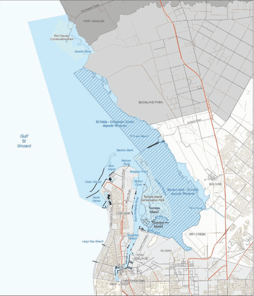
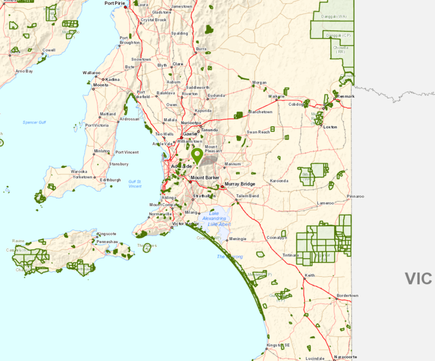
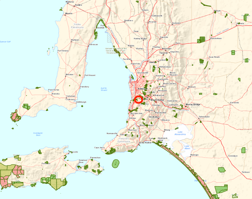
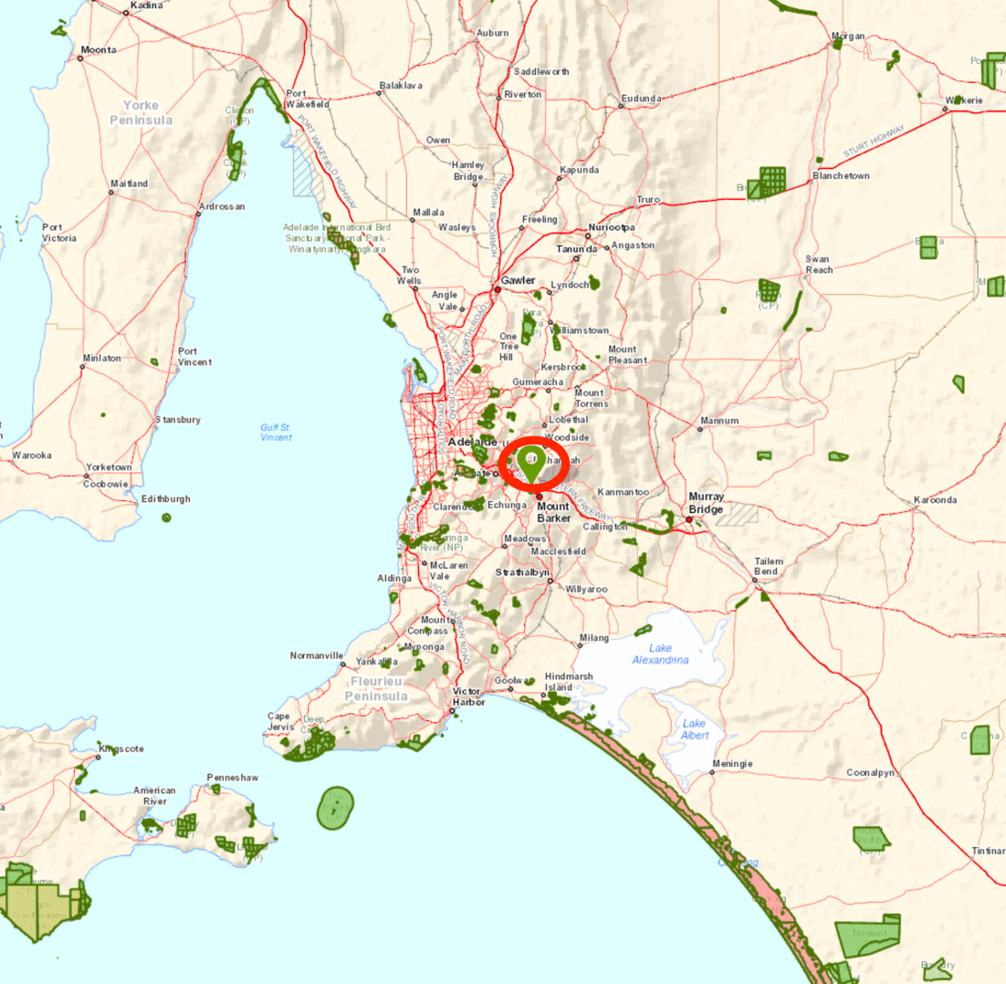
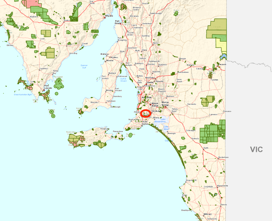
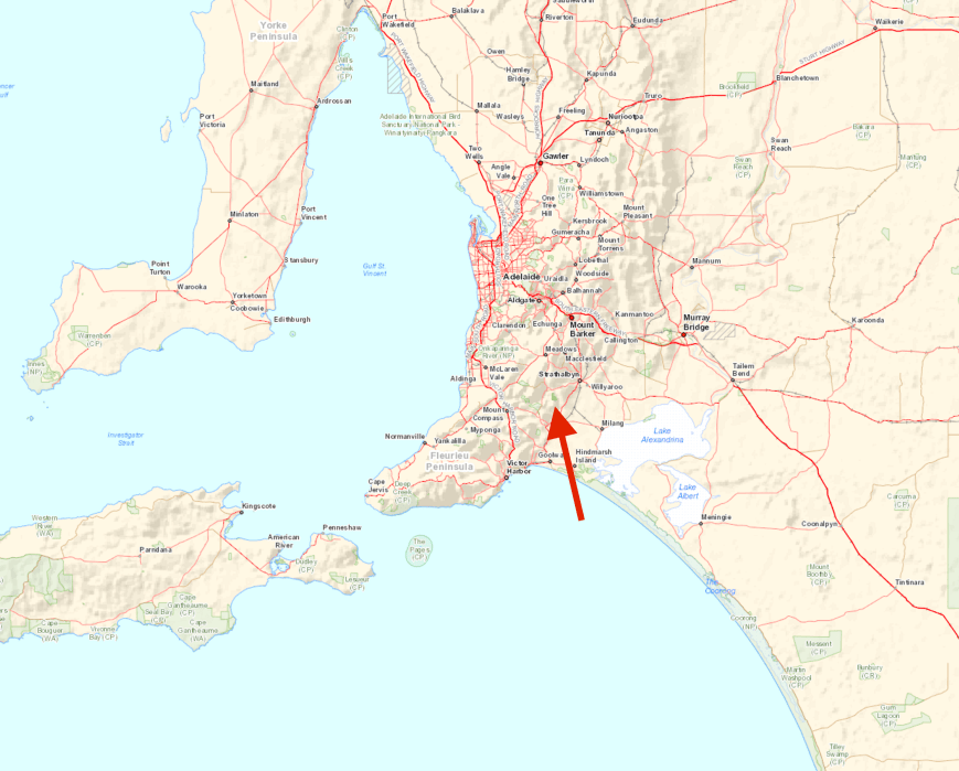
Above:- Map showing the location of the Adelaide Dolphin Sanctuary.  Map courtesy of Google maps.

The Adelaide Dolphin Sanctuary is located near Port Adelaide.  You could spend days here wandering around the streets of the Port.  Port Adelaide is well known for its well preserved 19th century buildings which reflect the maritime history of the area.

Amongst the many things to see is the and the Clipper ship, the City of Adelaide, which is the world’s oldest surviving clipper ship.  The City of Adelaide was built in Sunderland, England, and launched on 7th May 1864.  The ship was commissioned in the Royal Navy as HMS Carrick between 1923 and 1948 and, after decommissioning, was known as Carrick until 2001.  At a conference convened by HRH The Duke of Edinburgh in 2001, the decision was made to revert the ship’s name to City of Adelaide, and the duke formally renamed her at a ceremony in 2013.

When the City of Adelaide was decommissioned she was towed to the River Clyde in Scotland where it remained until 1991, when she sank.  She was recovered by the Scottish Maritime Museum and remained there in the slipway until the Scottish Maritime Museum was issued an eviction notice by the owners of the slipway.

In 2010, the Scottish Government decided that the ship would be moved to Adelaide, to be preserved as a museum ship. In September 2013 the ship moved by barge from Scotland to the Netherlands to prepare for transport to Australia. In late November 2013, loaded on the deck of a cargo ship, City of Adelaide departed Europe bound for Port Adelaide, Australia, where she arrived on 3 February 2014.

Port Adelaide is a busy port, although a large amount of the very large ships now berth at Outer Harbor.

Also located close to the sanctuary is the Adelaide Submarine Corporation, a naval shipbuilder for the Royal Australian Navy’s Collins class submarines and Hobart class destroyers.

The Adelaide Dolphin Sanctuary was established in June 2005 as a result of community concerns about the safety of the dolphins living in the Port Adelaide River and Barker Inlet and their environment.  During 2002 the South Australian Government undertook public consultation to gain an understanding of how the community wanted the dolphins cared for.  As a result of overwhelming support, the Parliament proclaimed The Adelaide Dolphin Sanctuary Act 2005.

The sanctuary which is known as one of the best and most easily accessible Dolphin Sanctuaries in the world, consists of an area of 118 square kilometres and is located on the eastern shore of Gulf St Vincent.  The sanctuary includes the Port Adelaide River and Barker Inlet and from there it stretches around to North Haven Marina, then north around Outer Harbor and up the coast to the Port Gawler Conservation Park.  The area includes a 10,000 year old mangrove forest, seagrass, saltmarsh, tidal flats, tidal creeks and estuarine rivers, all of which combine to provide habitat for dolphins and their food resources.

Screen Shot 2017-08-14 at 10.47.07 am.png

The sanctuary is home to around 30-40 resident Indo-Pacific bottlenose dolphins.  Around 300 or so dolphins are thought to regularly visit the area.  This species of dolphin grows to 2.6 metres (8.5 ft) long, and weighs up to 230 kilograms.  They are not to be confused with Common bottlenose dolphins.  Indo-Pacific bottlenose dolphins live in groups that can number in the hundreds, but groups of five to 15 dolphins are most common.  Their life span is around 40 years.  Dolphins can dive to depths of more than 500 metres, but they must surface for air every few minutes.  Like whales, dolphins breathe through a blowhole on the top of their heads.

Tursiops_aduncus,_Port_River,_Adelaide,_Australia_-_2003.jpg

A Port River dolphin.  Image courtesy of Wikipedia.

Other wildlife located in the sanctuary include Long nosed fur seals, Southern Eagle Rays, and the endangered Australia Sea Lion.

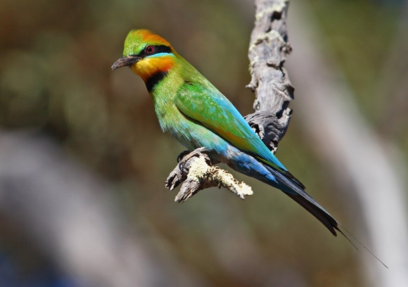
The area is also a popular bird watching site and shares most of its northern coastal habitat with the Adelaide International Bird Sanctuary.   The sanctuary is home to many species of birds including some rare and endangered species.  More than 250 species have been recorded.  Certainly during my visit, the area was alive with birdlife.  Some of those that I observed are captured in the photographs below.

This slideshow requires JavaScript.

The dolphins within the sanctuary are regularly under threat.  This includes marine litter and entanglement, harrassment and disturbance, disease, habitat degradation and pollution, and vessel strikes and noise.  Human activities include dredging, boat-generated wave action, anchoring, bait digging, illegal rubbish dumping, human foot traffic, industrial discharges, stormwater runoff, construction of wharves and shore reclamation.  Discarded fishing gear poses a high threat to dolphins within the sanctuary, with a number of dolphins having become entangled by fishing line, nets and rope.

IMG_0413

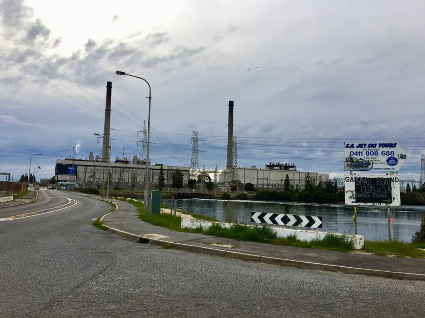
Above:- the nearby power station.

I decided to travel down Grand Trunkway and onto Garden Island.  The island was a major landfill site until 2001.   Garden Island is well known as being a ship’s graveyard.   Instead of scuttling obsolete vessels in deep water, the South Australian Harbours Board decided that an easier and cheaper option was to beach and further dismantle the stripped hulks at Garden Island.  There are a total of 25 wrecks known to have been abandoned at Garden Island.

Screen Shot 2017-08-15 at 10.18.48 am.png

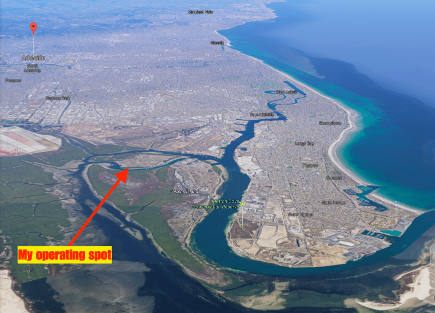
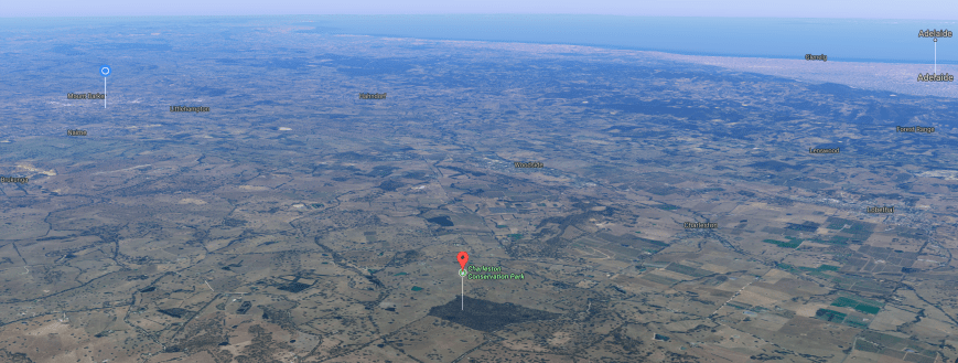
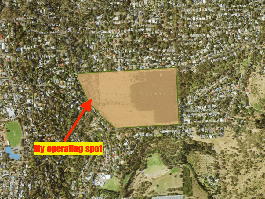
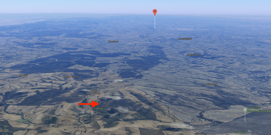
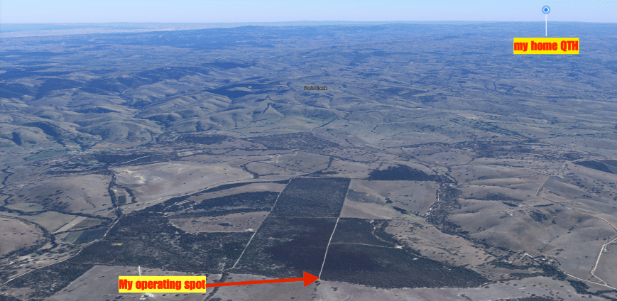
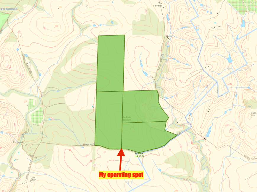
Above:- Aerial view of the Adelaide Dolphin Sanctuary, showing my operating spot.  Image courtesy of Google maps.

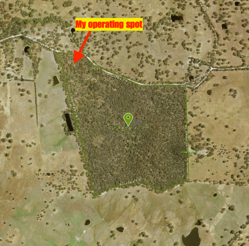
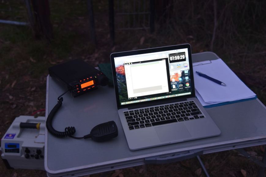
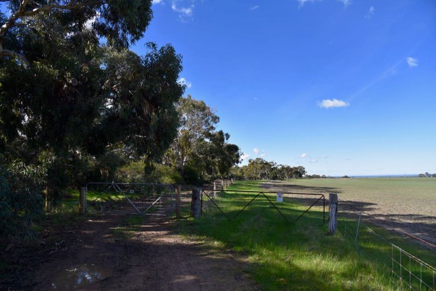
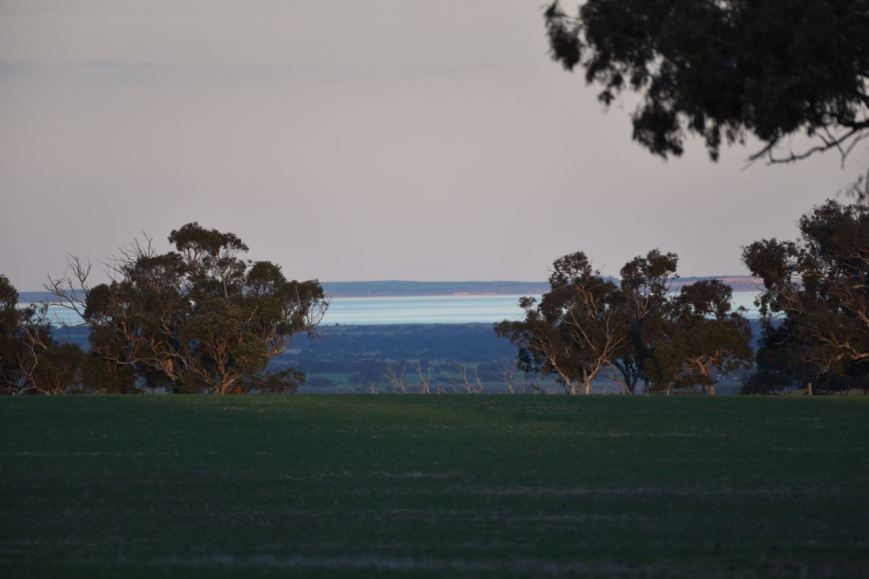
I travelled to the end of Garden Island Road and set up on the lawned area close to the waters edge, overlooking Angus Inlet.  As it was a warm and sunny day, this was an ideal place to set up, underneath the shade of the trees.

Screen Shot 2017-08-15 at 10.14.44 am.png

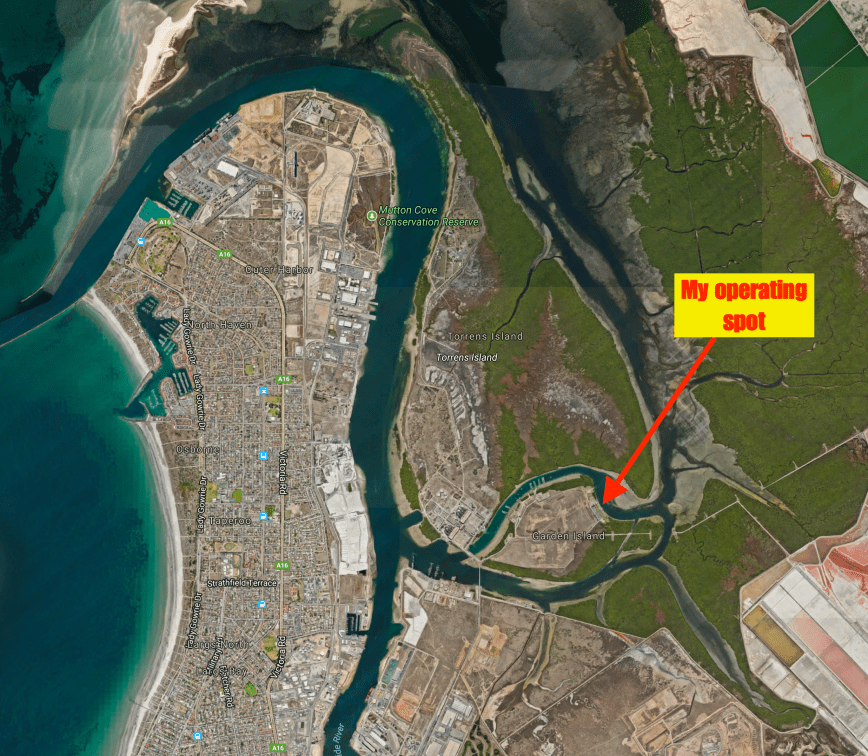
Above:- Aerial shot showing my operating spot.  Image courtesy of Google maps.

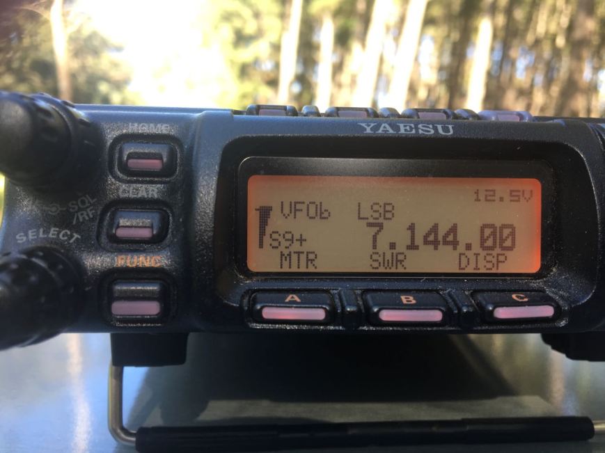
I was a little worried about potential noise, as the power station was nearby, along with the huge power lines running out of the station to Adelaide.  And my fears were confirmed when I switched on the Yaesu FT-857d.  I had strength 8 noise.  I decided to box on and put up with the noise, rather than packing up and relocating.  I suspect that most operating spots in the sanctuary would be noisy due to the large amount of industry in the area.

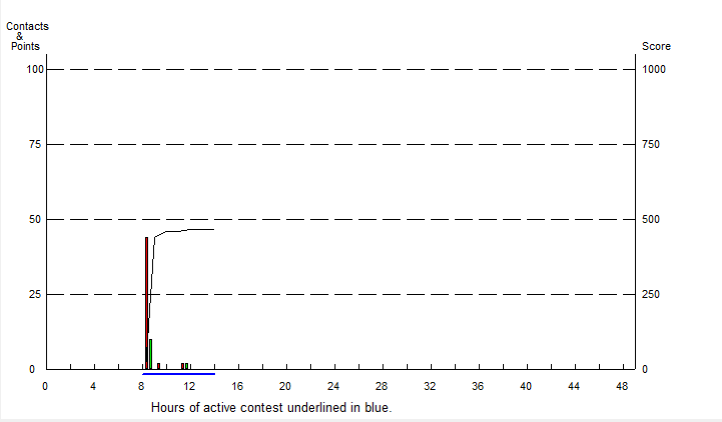
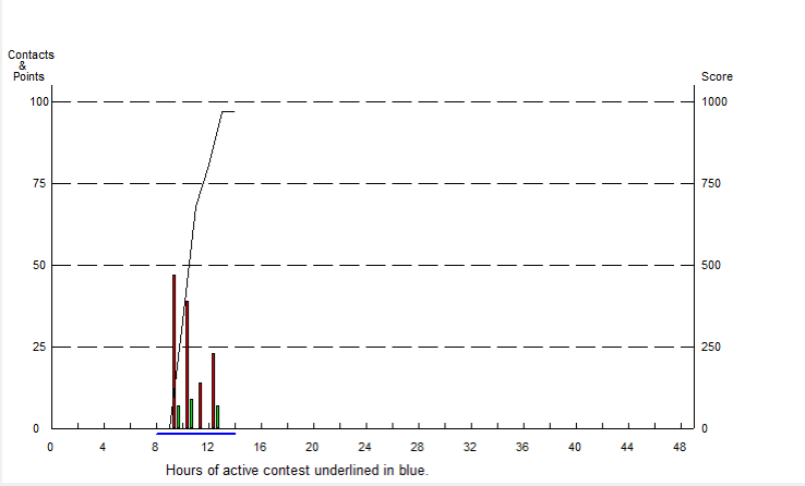
First in the log was Yern VK2KJJ, followed by Dennis VK2HHA, and then Tom VK5ZTS in the northern suburbs of Adelaide.  Tom had a great 5/9 + signal.  It was clear that propagation into Adelaide was going to be good during this activation, due to ground wave.  Contact number 10, qualifying the park for me for VKFF was with Nik VK3NLK, about 15 minutes into the activation.

The noise floor did drop to strength 7 during the activation, but it was still very hard going pulling out some of the lower signals.  I apologise to those who were calling that I was unable to work.  I know there were a number of stations who called that I was just unable to pull through the noise.

I logged a total of 47 stations on the 40m band from VK2, VK3, VK4, VK5, VK6 and VK7.  I then called CQ on 3.610 on the 80m band where I logged 3 contacts.  They being with Ron VK5MRE in the Riverland, who had followed me down from 40m.  Also Greg VK5GJ in the Adelaide Hills and Yern VK2KJJ in Wagga Wagga.  Very pleased with that contact considering the time of day on 80m.

To wrap up the activation I called CQ on 14.310 on the 20m band.  Unfortunately Rick VK4RF/VK4HA was the only station logged there.

Whilst activating I observed a number of dolphins cruising by in Angus Inlet.

After just short of 2 hours in the park it was time to go QRT and head for home.  I had a total of 52 contacts in the log and another unique park to add to my activator tally.

I worked the following stations on 40m SSB:-

  1. VK2KJJ
  2. VK2HHA
  3. VK5ZTS
  4. VK3ARH
  5. VK3PF
  6. VK7JON
  7. VK2YK
  8. VK4RZ
  9. VK3SQ
  10. VK3NLK
  11. VK5KIK
  12. VK5KDK
  13. VK4TJ
  14. VK4/AC8WN
  15. VK4/VE6XT
  16. VK5BJE
  17. VK3FLJD
  18. VK3HBG
  19. VK4HNS/p
  20. VK2QK
  21. VK2JNG/m
  22. VK3FNQS
  23. VK3NQS
  24. VK3AMX
  25. VK4RF
  26. VK4HA
  27. VK5HYZ
  28. VK3GGG
  29. VK3PMG
  30. VK2YW
  31. VK3BNJ
  32. VK3LCW
  33. VK2KYO
  34. VK5KLV
  35. VK3BBB
  36. VK3VGB
  37. VK3MROZ/m
  38. VK3MRH
  39. VK2NP
  40. VK6XN
  41. VK4SMA
  42. VK5MR
  43. VK3FI
  44. VK2TH
  45. VK3FLCS
  46. VK5MRE
  47. VK3SFG

I worked the following stations on 80m SSB:-

  1. VK5MRE
  2. VK5GJ
  3. VK2KJJ

I worked the following stations on 20m SSB:-

  1. VK4RF
  2. VK4HA


References.

Department for Environment and Heritage, 2007, Adelaide Dolphin Sanctuary Management Plan.

Department of Environment Water and Natural Resources, 2017, <https://www.environment.sa.gov.au/our-places/Heritage/maritime-heritage/visiting-shipwrecks/shipwreck-trails/Garden_Island&gt;, viewed 15th August 2017

Government of South Australia, 2014, Adelaide Dolphin Sanctuary users Guide

National Parks South Australia, 2017, <https://www.environment.sa.gov.au/parks/Find_a_Park/Browse_by_region/Adelaide/adelaide-dolphin-sanctuary&gt;, viewed 15th August 2017

Wikipedia, 2017, <https://en.wikipedia.org/wiki/Port_Adelaide&gt;, viewed 15th August 2017

Wikipedia, 2017, <https://en.wikipedia.org/wiki/Indo-Pacific_bottlenose_dolphin&gt;, viewed 15th August 2017

Nurragi Conservation Reserve VKFF-2247

On the weekend just gone I was working afternoon shift and as a result would not be able to compete in the Remembrance Day Contest.  This was a real shame as the weather was fantastic and I was hoping to go portable for the contest.  So instead I decided for a quick morning activation on Saturday 12th August 2017.

I headed to the Nurragi Conservation Reserve VKFF-2247, which is located about 70 km south east of Adelaide.  This is a newly added park to the World Wide Flora Fauna (WWFF) program, and my activation would be the first time the park had been put on air.

Screen Shot 2017-08-11 at 12.39.04 pm.png

Above: Map showing the location of the Nurragi Conservation Park, south east of Adelaide.  Map courtesy of Location SA Map Viewer.

The Nurragi Conservation Reserve follows the old branch railway line to Milang and runs a distance of about 12 km, from Sandergrove to Milang.  The park is about 65 hectares in size.  The Friends of Nurragi was established in 1988 to protect and restore the reserve and in 1991 the Minister of Lands dedicated the area as a Nature Conservation and Plantation Reserve under the Crown Lands Act 1929.

The reserve forms a wildlife corridor linking the eastern Mount Lofty Ranges with Lake Alexandrina and contains extremely important vegetation in a region that has been cleared of over 98% of its original cover.   More than 300 native plant species are present, with over 50 of those being of particular conservation significance (eg rare or endangered).   It preserves remnant mallee vegetation including square-fruited mallee, narrow-leaved red mallee, peppermint box, and native apricot.  Understorey plants include wallowa, needle bush wattle and broombush.

During my visit there were a few flowering native plants, particularly the wattles, which were vivid yellow.

Over 95 species of birds have been recorded in the park including Peaceful Dove, Weebill, Australian Magpie, Little Raven, Grey Shrikethrush, Diamond Firetail, Southern Boobook, Red-capped Robin, Hooded Robin, and Rufous Whistler.  Native mammals found in the park include Western Grey kangaroos, Brush-tailed possums and bats.  About 11 reptile species have been recorded including the Sand Goanna.

During my visit the park was alive with New Holland Honeyeaters and Superb Fairy Wrens.  I also spotted a Shrike Thrush (I think?)

I was pleasantly surprised to find a number of interpretive signs in the park, no doubt the result of the hard work of the Friends of Nurragi.

The park commences at the town of Milang, which is located on the banks of Lake Alexandrina.  Between 1860 and 1880 Milang was one of South Australia’s busiest ports.  It connected Adelaide with the thriving river trade.  Wool from the Darling and Upper Murray stations was landed at Milang and then transported by horse and bullock teams to Port Adelaide. Wheat was transported to Milang, processed at its flour mills and then shipped back as flour.

A number of historic buildings remain in Milang.  But sadly, an impressive group of Landseer buildings which stood in the main street were demolished in the 1950’s and replaced by the present day shopping centre.  What a great shame!  Albert Landseer was one of South Australia’s principal river merchants.

KoppDrawing

Above:- Milang in the late 1800’s.  Image courtesy of http://www.milang.org.au

milang-photo.jpg

Above:- the former Landseer buidlings in the main street of Milang.  Image courtesy of http://www.murrayriver.com.au

In May 1854, the first public railway in South Australia was completed, linking Goolwa and Port Elliot.  The success of the Goolwa-Port Elliot line aroused interest in Strathalbyn where local business men saw advantages for them in a direct link with the new port at Victor Harbor.  In 1857 a group of 20 people attended a meeting at the Lake Hotel in Milang, in support of a line from Strathalbyn to Milang.  Unfortunately a larger meeting at Strathalbyn resulted in confirmation that the line would run from Strathalbyn to Middleton on the south coast.

In 1881 there was a new push for a branch line to Milang.  A Select Committee was appointed by the South Australian Government.  On the 8th November 1881 the House of Assembly passed the ‘Strathalbyn and Milang Railway Bill’.  Tenders for the construction of both lines were called on the 18th April 1882 and Walker and Swann were successful in obtaining the joint contract for a price of ₤143,678.

The Milang branch line was opened  on the 17th December 1884 from a junction with the Victor Harbor line at Sandergrove.  At Sandergrove the Milang line served as the passing siding for the station, sharing an island passenger platform with the Victor Harbor main line.  A goods siding also catered for local goods consignments.  The only intermediate station was at Nurragi where there was a 70m long goods siding.  There was also a passenger stop at Punkulde where the line crossed the Milang-Finniss road.

At one stage there was a small turntable at Sandergrove to turn locomotives working to Milang.  Through most of its later life the branchline was operated with Brill railcars.  The last passenger service ran 30 November 1968 with the line closed on 17th June 1970.

PG006.jpg

Above:- a loco on the Milang branch line

If you are in Milang I highly recommend a visit to the Port Milang Historic Railway Museum.  The museum is located on the banks of Lake Alexandrina and tells the story of the Lakes Railways, displays a collection of South Australian rolling stock and equipment.

Although the Milang line has long since closed, the line between Mount Barker where I live, and Victor Harbor, is still used by SteamRanger Heritage Railway which runs a number of different heritage steam and diesel hauled tourist trains through the Adelaide Hills and along the South Coast to Victor Harbor.

DSC_7735

Above:- the Mount Barker to Victor Habor line.

I set up right in the middle of the park, off Nurragi Road.  There was a small area here off the road for me to park the vehicle, and make a short walk to where I set up.  I ran my normal portable set up for this activation consisting of the Yaesu FT-857d, 40 watts output, and the 80/40/20m linked dipole, inverted vee at 7 metres at the apex.

Screen Shot 2017-08-11 at 12.48.27 pm.png

Above:- Aerial shot of the park (indicated in blue), showing my operating spot.  Image courtesy of http://www.railtrails.org.au

I was all set up and ready to go by around 9.30 a.m. local time.  First in the log was Peter VK3PF, who is well and truly leading the pack when it comes to park hunters in Australia.  Next was another keen park hunter, Dennis VK2HHA from Albury, followed by my good wife Marija VK5FMAZ.  It was very slow going and I had real doubts that I was not going to reach my 44 contacts which are required to qualify the park for the global WWFF program.  Contact number 10, qualifying the park for me for the VKFF program, was with Kevin VK3HKK.

Shortly afterwards I worked Stef VK5HSX who was portable in the Girraween National Park VKFF-0198.  It is always nice to get a Park to Park contact in the log during an acivation.  I went on to work a total of 22 stations on the 40m band before callers dried up.  I headed over to the 80m band where I called CQ on 3.610.  This was answered by John VK5NJ in Mount Gambier who was booming in at 5/9 +.  Mark VK5QI then called, followed by Les VK5KLV at Port Augusta in the north of South Australia, and then Mick VK3GGG/VK3PMG in western Victoria.

I then headed back to the 40m band where I logged a further 31 stations from VK2, VK3, VK4, VK5, and VK7.  My 44th contact came at 90 minutes into the activation, with a QSO with Andrew VK5MR at Roxby Downs in the north of South Australia.

I then headed back to 80m hoping to get my wife Marija VK5FMAZ in the log.  She had just arrived home from shopping and we had corresponded via SMS.  Marija was my first taker after calling CQ, followed by David VK5PL in the Barossa Valley and then Wolf VK5WF in Adelaide.  I then worked Geoff VK3SQ at Beechworth in north eastern Victoria, John VK5BJE in the Adelaide Hills, and finally Allen VK3ARH.  More proof that 80m works very well, even in the middle of the day.

I then received a SMS message from David VK5KC to advise he was portable in a park on the Eyre Peninsula.  So I quickly lowered the squid pole and removed the 80m links and headed to 7.144.  I logged David who was activating the Laura Bay Conservation Park VKFF-1048.

I then tried my luck on 20m.  It was too early for any DX, but I did log a total of 4 stations from VK4 and VK6.  To finish off the activation I moved back to 7.135 on 40m where I picked up 2 more stations.

It was approaching 12.30 p.m. and I needed to pack up and head home for some lunch and a shower, and then off to work.  I had a total of 71 contacts in the log and another unique park activated.  Thanks to everyone who called and thanks to those who spotted me.

I worked the following stations on 40m SSB:-

  1. VK3PF
  2. VK2HHA
  3. VK5FMAZ
  4. VK3NLK
  5. VK2WG
  6. VK2MT/p
  7. VK6HRC/p
  8. VK2QK
  9. VK3SFG
  10. VK3HKK
  11. VK4CPS
  12. VK3KMH
  13. VK3MRO/m
  14. VK5HSX/4 (Girraween National Park VKFF-0198)
  15. VK2PKT
  16. VK1DI
  17. VK6XN
  18. VK2NP
  19. VK3JP
  20. VK4PDX
  21. VK3MCK
  22. VK2LEE
  23. VK2KYO
  24. VK2VW
  25. VK4TJ
  26. VK4/AC8WN
  27. VK4/VE6XT
  28. VK2YK
  29. VK3GYH
  30. VK3GGG
  31. VK3PMG
  32. VK3MCD/p
  33. VK3FRAB
  34. VK3FMJP
  35. VK3TKK/m
  36. VK2JDR
  37. VK3FOGY
  38. VK2MTC
  39. VK5MR
  40. VK3BBB
  41. VK3JDA
  42. VK3MKM
  43. VK3ZZS/p
  44. VK3SQ
  45. VK2MSQ
  46. VK5KLV
  47. VK3ZVX
  48. VK3ER
  49. VK3FOTO/m
  50. VK7JON
  51. VK7NWT
  52. VK5GJ
  53. VK2GKA
  54. VK5KC/p (Laura Bay Conservation Park VKFF-1048)
  55. VK3STU
  56. VK7GG

I worked the following stations on 80m SSB:-

  1. VK5NJ
  2. VK5QI
  3. VK5KLV
  4. VK3GGG
  5. VK3PMG
  6. VK5FMAZ
  7. VK5PL
  8. VK5WF
  9. VK3SQ
  10. VK5BJE
  11. VK3ARH

I worked the following stations on 20m SSB:-

  1. VK4QQ
  2. VK4ZD
  3. VK6AKT
  4. VK4TJ


References.

Birds SA, 2017, <http://www.birdssa.asn.au/location/nurragi-conservation-reserve/&gt;, viewed 11th August 2017

Milang, 2017, <http://milang.org.au/history/&gt;, viewed 14th August 2017

National Trust, 2017, <https://www.nationaltrust.org.au/places/nurragi-conservation-reserve/&gt;, viewed 11th August 2017

Steamranger, 2017, <http://www.steamranger.org.au/enthusiast/guides/guide7.htm&gt;, viewed 11th August 2017

Walking SA, 2017, <https://www.walkingsa.org.au/walk/find-a-place-to-walk/nurragi-conservation-reserve-walking-trail/&gt;, viewed 11th August 2017

Charleston Conservation Park 5CP-041 and VKFF-0777

I had a day off today (Saturday 29th July 2017) after a few afternoon shifts, and despite it being a rather unpleasant day outside, I decided late in the morning to head over to the Charleston Conservation Park 5CP-041 & VKFF-0777.  The park is just a short 23 km drive by road from my home, and about 46 km east of Adelaide.

Screen Shot 2017-07-29 at 11.46.44 am.png

Above:- Map showing the location of the Charleston Conservation Park in the Adelaide Hills.  Map courtesy of Location SA Map Viewer.

I have activated the park many times previously, so today’s activation was mostly for the recently released Boomerang Award in the VKFF program, which encourages park activators to head back to the same park.

Screen Shot 2017-07-29 at 11.43.57 am.png

Aerial shot showing the park, with my QTH to the left of the shot.  Adelaide is in the background.  Image courtesy of Google maps.

Charleston is 54 hectares in size and was first proclaimed on the 8th April 1976.  Most of the habitat within the park is Woodland with either Manna Gum or Rough-barked Manna Gum over Golden Wattle.

Over 100 species of bird have been recorded in the park including Adelaide Rosella, Striated Pardalote, Australian Golden Whistler, Grey Shrikethrush, Willie Wagtail, Australian Magpie, and Painted Buttonquail.

This slideshow requires JavaScript.

The park is located about 8 km east of the little town of Charleston, which was laid out in 1857 by Charles Dunn (1796–1881), a brother of the prominent miller John Dunn.  It is believed the town was originally known as “Charlestown”, but the current spelling has always been more common in newspaper reports.

I travelled along some of the ‘back roads’ to get to the park.  As it is winter, the countryside was beautitful and green.

I soon reached the park on Bell Springs Road.  This is the only way to access the park.  There is a small car parking area at gate one.  As I was pulling up at the park I worked Gerard VK2JNG who was portable in the Kwiambal National Park VKFF-0274

I set up on the boundary track on the western side of the park.  My usual portable gear was used for this activation: Yaesu FT-857d, 40 watts, and the 20/40/80m linked deipole, inverted vee @ 7 metres.

Screen Shot 2017-07-29 at 11.46.26 am.png

Above:- Aerial shot of the park showing my operating spot.  Image courtesy of Location SA Map Viewer.

It was incredibly windy with a very nasty storm front approaching from the west.  As a result it took me a little longer than normal to get set up, as I continually got the antenna caught up in the branches of the gum trees.  I headed to 7.144 hoping to get a Park to Park with Gerard VK2JNG, but there was silence.  I asked if the frequency was in use and I was very pleased to hear Gerard come back to me to advise that he was waiting for me.  I logged Gerard who was an excellent 5/9 signal.

I then headed down to 7.139 and asked if the frequency was in use, with Dennis VK2HHA coming back to advise that it was all clear.  I logged Dennis, followed by Peter VK3PF, Marija VK5FMAZ, and then Rick VK4RF/VK4HA.  Despite it being a weekend, there was not the normal flurry of callers.  More like a constant flow.  Contact number 10 was with Steve VK7CW after 10 minutes of being on air in the park.

I had 24 contacts in the log when I was approached by 2 bushwalkers and a young child.  They showed great interest in what I was doing.  Thanks to those who patiently waited whilst I was chatting and explaining the hobby to them.  They were extremely amazed hearing such strong signals coming in from interstate.

When things slowed down a little I took the opportunity of heading down to 7.090 where I had seen a spot on parksnpeaks for Matt VK1MA/2 on a SOTA peak.  When I first heard Matt he was a good 5/7, but within a minute I had almost lost him.  Sadly I wasn’t able to make contact with Matt.  So I headed back up to 7.139 where I logged a further 4 stations.

As I had very few callers I headed back to 7.090 where I managed to get through to Matt after a few goes.  I was hearing Matt okay at 5/3, but he was struggling with my signal, 3/3, at his end.  But we made it.

I then headed off to the 20m band where I called CQ after self spotting on parksnpeaks.  Unfortunately my only contact on 20m was with Anthony VK6MAC in Western Australia.

The weather was moving in fast, so I decided to try my luck on the 80m band.  I called CQ and received a call from Geoff VK3SQ at Beechworth.  I was able to hear Geoff quite well as there was no noise in the park, but sadly Geoff was unable to hear me.  First in the log on 80m was my wife Marija VK5FMAZ, followed by Tony VK5MRT, and finally David VK5PL.

I decided to have one last listen on 40m before calling it quits for the day.  Unfortunately I couldn’t get back onto 7.139 as there were some stations there already, and I had to go up to 7.150 as one of those stations was very wide.  I logged a further 4 stations including Owen VK2AEJ/p at the Cape Don lightship in Sydney.  The MV Cape Don is a former lighthosue tender, now a museum ship in Waverton in New South Wales.

MV_Cape_Don

Above: the MV Cape Don.  Image courtesy of wikipedia

It was time to go QRT as I was just starting to experience some drops of rain.  I had a total of 44 contacts in the log.

After packing up I went for a walk along the boundary track on the western side of the park.  I highly recommend this, as the park becomes very picturesque as you get further into the park.  I came across a few fenced off areas in the park and some other marked out areas.  Not sure what they were for?

I worked the following stations on 40m SSB:-

  1. VK2JNG/p (Kwiambal National Park)
  2. VK2HHA
  3. VK3PF
  4. VK5FMAZ
  5. VK4RF
  6. VK4HA
  7. VK3NCR/m
  8. VK3FAHS/m
  9. VK2LEE
  10. VK7CW
  11. VK3TKK
  12. VK2YK
  13. VK3NLK
  14. VK2KYO
  15. VK3FCMC
  16. VK3ZPF
  17. VK6MAC
  18. VK2VW
  19. VK3ARH
  20. VK2NEO
  21. VK6BEC
  22. VK3SQ
  23. VK3TQ
  24. VK3VEF
  25. VK3ANL
  26. VK2JDR
  27. VK2NP
  28. VK3PAT
  29. VK3FDAP
  30. VK3RU
  31. VK4HNS
  32. VK4TJ
  33. VK2JNG/m
  34. VK7VZ
  35. VK3SIM
  36. VK1MA/2 (SOTA VK2/ ST-001)
  37. VK4AAC
  38. VK2EIR/m
  39. VK2SVM
  40. VK2AEJ/p (MV Cape Don lighthship)

I worked the following station on 20m SSB:-

  1. VK6MAC

I worked the following stations on 80m SSB:-

  1. VK5FMAZ
  2. VK5MRT
  3. VK5PL


References.

Birds SA, 2017, <http://www.birdssa.asn.au/location/charleston-conservation-park/&gt;, viewed 29th July 2017

Wikipedia, 2017, <https://en.wikipedia.org/wiki/Charleston,_South_Australia&gt;, viewed 29th July 2017

Sturt Gorge Recreation Park VKFF-1750

Today (Sunday 23rd July 2017) Marija VK5FMAZ and I activated the Sturt Gorge Recreation Park VKFF-1750.  The park is located about 13 km south of Adelaide.

It was quite a miserable day compared to the day before which was bright and sunny.  But despite the rather gloomy weather, we decided to head out.  We had attended a friend’s house the night before for dinner for an event called ‘The Longest Table’, the Hospital Research Foundation’s annual cancer fundraiser.  I had indulged in more than a bit of red wine, so I figured some fresh air would be of benefit to me

Screen Shot 2017-07-23 at 8.59.11 pm.png

Above:- Map showing the location of the Sturt Gorge Recreation Park.  Map courtesy of Location SA Map Viewer.

The Sturt Gorge Recreation Park is 244 hectares (600 acres) in size and was established on the 4th October 1973.  The park lies between the suburbs of Bellevue Heights and Flagstaff Hill along the Sturt River.

DSC_7671

During the 1964, Mr. Robin Millhouse, the Member for Mitcham (later to become the Attorney General of SA) raised the issue in Parliament of acquiring Sturt Gorge for use as a National Park.  In a letter to the Minister of Lands dated 6th August 1964 Millhouse stated:

“The area I have in mind is that below the flood control dam site.  I am sure you would agree that it is most suitable for a National Park”.

Unfortunately no action was taken by the Government, and in January 1966, Millhouse again raised the question with the new Minister of Lands, Mr. J.D. Corcoran.  They both visited the area and later requested action be taken under the Town Planning Act to ensure that no subdividing for housing took place in the area.  Unfortunately no powers exited at the time for this, and several applications to subdivide were received in 1965-1966.

Millhouse then had discussions with the de Rose family who owned the land and found the property was available for sale at the price of 70,000 pounds.  Millhouse conveyed this information to the State Government who replied stating:

“The present Government is unable to contemplate the purchase of the area at this stage”.

In June 1966, Millhouse again raise the matter in Parliament, and in the following month, the de Rose family were approached by land developers and subsequently sold the land.  Millhouse continued to apply pressure, and was supported by a campaign by the Geological Monuments Subcommittee of the S.A. Division of the Geological Society of Australia.  Between 1969 and 1972, the applied pressure appears to have paid off, with the State Government purchasing in pieces the land from the two development companies.  In 1973 the Sturt Gorge was proclaimed as a Recreation Park.

c6bca0b9a038951dc3f4c8f223fcaabd.jpg

Above:- Robin Millhouse.  Image courtesy of http://www.adelaidenow.com.au

The park is internationally recognised as an area of conservation and geological significance.  Sturt Gorge conserves the nationally threatened greybox grassy woodland vegetation which was once abundant across southern Australia.  It is the second largest remnant area of grey box open woodland managed by the Department of Environment Water & Natural Resources.  Along the Sturt River there are numerous River Red Gums.  North of the river there are areas of drooping sheaoak woodland over twiggy daisy-bush and sticky hop-bush.  At the western end of the park the habitat is mostly exotic with some native grasses.

The park is also home to a rock formation, known as sturt tillite, that is believed to have been formed from glacial material dropped from ice floating in the ocean that covered South Australia 800 million years ago.

Screen Shot 2017-07-23 at 9.56.47 pm.png

Above:- Aerial view of the park, in close proximity to Adelaide.  Image courtesy of Google maps

The Sturt River, also known as Warri Parri, carves its way through the park.  The river rises in Upper Sturt and flows through Corromandel Valley, the Sturt Gorge Recereation Park, the southern suburbs of Marion and Morphettville, before meeting the Patawalonga River in Glenelg North, the end of its 27 km course.  It was named after the famous explorer, Captain Charles Sturt.

Charles_Sturt_by_John_Michael_Crossland_lowres_color.jpg

Above:- Captain Charles Sturt.  Image courtesy of wikipedia.

The Sturt River Flood Control Dam can be located in the park.  It is well worth a look, as there are some great views of the gorge from the 40 metre high dam wall.  But beware, the walk back up to the car park area is quite steep.

Over 115 species of bird have been recorded in the park including Crimson  Rosella, Superb Fairywren, New Holland Honeyeater, Red Wattlebird, Whiteplumed honeyeater, White-browed Babbler, Grey Shrikethrush, Peregrine Falcon, and Sacred Kingfisher.

The park is also home to a large amount of native wildlife including kangaroos and koalas.

For more information on the park, have a look at the Friends of Sturt Gorge website at…..

http://www.fosg.org.au/park.html

Marija and I operated from inside gate 20 at the end of Craigburn Road.  We ran the Yaesu FT-857d (set at 10 watts PEP for Marija, and 40 watts for me), and the 80/40/20m linked dipole supported on the 7 m squid pole, inverted vee.

Screen Shot 2017-07-23 at 8.57.16 pm.png

Above:- Map of the Sturt Gorge Recreation Park showing our operating spot.  Map courtesy of National Parks South Australia.

This was to be a unique park for both Marija and I for the World Wide Flora Fauna (WWFF) program.  Marija started off the activation and was content in obtaining 10 QSOs, qualifying the park for the VKFF program.  We headed to our nominated operating frequency of 7.144 and found Gerard VK2JNG/p who was activating the Rocky Glen National Park VKFF-1179.  We both logged Gerard, Park to Park, and then headed down to 7.135 where Marija called CQ.  Marija’s second contact was another Park to Park, this time with Peter VK3PF/p in the Glenmaggie Regional Park VKFF-1877.

Marija had soon racked up 10 contacts, thus qualifying the park for VKFF.  Contact number 10 being with Adam VK2YK.  Shortly after we also worked Neil VK4HNS/p who was activating theSpringwood Conservation Park VKFF-1653.  Marija logged a total of 13 stations from VK2, VK3, VK4,, and VK7, before we swapped the mic.

I then called CQ on 7.135, with my first taker being Lee VK2LEE, followed by Ron VK3MRH, and then Dennis VK2HHA.  Contact number 10, with Steve VK7CW, soon followed.  Despite it being a Sunday, there was not the normal flurry of callers.  Band conditions also seemed to be down a little, with quite a bit of QSB on the signals.  But despite this, I logged my 44th contact, a little over an hour into the activation.  Contact number 44 was with Murray VK3MJT.

Whilst I was on air, Marija had a number of chats with interested onlookers, explaining what we were doing and all about the hobby of amateur radio.  Park activating is always a great way of promoting the hobby.

I logged a total of 46 stations on 40m from VK2, VK3, VK4, VK5, VK6, and VK7, before we lowered the squid pole, and inserted the 80m links.  I called CQ on 80m with John VK5BJE coming back with a very solid 5/9 + signal.  But sadly John was my only caller on 80m.

The weather was becoming quite threatening, and it was a chilly 13 deg C, so I quickly tried my luck on 14.310 on the 20m band.  Anthony VK6MAC was my first caller there with a good strong 5/8 signal from Western Australia, followed by Fred VK4FE in far north Queensland, and then Hans VK6XN.  Sadly I had to go QRT very quickly with Hans as the heavens opened up.  It was mad dash to pack up the gear and head back to the vehicle.

It was time to head home.  We had both successfully qualified the park for VKFF and I had also achieved 44 QSOs, qualifying the park for the WWFF global program.  And a brand new park to add to our activator list.  Thanks to everyone who called.

Marija worked the following stations on 40m SSB:-

  1. VK2JNG/p (Rocky Glen National Park VKFF-1179)
  2. VK3PF/p (Glenmaggie Regional Park VKFF-1877)
  3. VK3IRM
  4. VK2PKT
  5. VK7NWT
  6. VK3FSPG
  7. VK3MPR
  8. VK3MRH
  9. VK2HH
  10. VK2YK
  11. VK2VW
  12. VK4HNS/p (Springwood Conservation Park VKFF-1653)
  13. VK3KMH

I worked the following stations on 40m SSB:-

  1. VK2JNG/p (Rocky Glen National Park VKFF-1179)
  2. VK3PF/p (Glenmaggie Regional Park VKFF-1877)
  3. VK2LEE
  4. VK3MRH
  5. VK2HHA
  6. VK2YK
  7. VK3FSPG
  8. VK3MPR
  9. VK3SS
  10. VK7CW
  11. VK3ANL
  12. VK3ANP
  13. VK4RZ
  14. VK3SQ
  15. VK7JON
  16. VK3VIN
  17. VK4RF
  18. VK4HA
  19. VK2GZ
  20. VK2GKA/m
  21. VK2FOUZ
  22. VK3IRM
  23. VK2STO
  24. VK3FEVT
  25. VK6MAC
  26. VK2JAZ
  27. VK3CWF
  28. VK3ZPF
  29. VK5ZZ
  30. VK5TR
  31. VK3FRAB
  32. VK4SMA
  33. VK3UH
  34. VK4TJ
  35. VK4HNS/p (Springwood Conservation Park VKFF-1653)
  36. VK3KMH
  37. VK4FFAB
  38. VK5YL
  39. VK2VRC
  40. VK2JNG/m
  41. VK2HPN
  42. VK3HKK
  43. VK2NP
  44. VK3MJT
  45. VK6XN
  46. VK5BJE

I worked the following station on 80m SSB:-

  1. VK5BJE

I worked the following stations on 20m SSB:-

  1. VK6MAC
  2. VK4FE
  3. VK6XN


References.

Birds SA, 2017, <http://www.birdssa.asn.au/location/sturt-gorge-recreation-park/&gt;, viewed 23rd July 2017

Friends of Sturt Gorge, 2017, <http://www.fosg.org.au/index.html&gt;, viewed 23rd July 2017

National Parks South Australia, 2017, <https://www.environment.sa.gov.au/parks/Find_a_Park/Browse_by_region/Adelaide/sturt-gorge-recreation-park&gt;, viewed 23rd July 2017

Wikipedia, 2017, <https://en.wikipedia.org/wiki/Sturt_Gorge_Recreation_Park&gt;, viewed 23rd July 2017

Wikipedia, 2017, <https://en.wikipedia.org/wiki/Sturt_River&gt;, viewed 23rd July 2017

Blackwood Forest Recreation Park VKFF-1686

Yesterday (Saturday 22nd July 2017) I activated the Blackwood Forest Recreation Park VKFF-1686 which is located about 13 km south of Adelaide, in the Mount Lofty Ranges ‘Adelaide Hills’.  The park is located at Hawthorndene in the Coromandel Valley.

This was to be a unique park for me as an activator for the World Wide Flora Fauna (WWFF) program, and the very first time the park had been activated.

Screen Shot 2017-07-22 at 4.45.28 pm.png

Above:- Map showing the location of the Blackwood Forest Recreation Park.  Map courtesy of Location SA Map Viewer.

The Blackwood Forest Recreation Park was first acquired by the South Australian State Government in 1908 for use as an experimental orchard.  It continued to be used for horticultural research until the 1960s.  From the mid 1980’s there was sustained public concern over a period of more than 15 years, seeking to have the 21 hectares of land retained as open space.  This resulted in the Blackwood Forest Recreation Park being proclaimed a Recreation Park under the National Parks and Wildlife Act in November 2001.

DSC_7611

There is limited natural vegetation in the park.  Some native vegetation can be found on the eastern boundary of the park, while some old River Red Gums and Acacia species can be found along Minno Creek on the western boundary of the park.  About 8 hectares of the park is Monterey Pine, with the remainder of the park being open grassland.  A few of the original trees from the orchard remain today, including walnuts, pecans, loquats, mulberries, quinces, greenguage plums.  A row of 27 named varieties of olives can be located along the Turners Avenue boundary of the park. These olives are officially listed by The National Trust of South Australia as being locally historically important.

There are a number of walking tracks in the park, and as it was a beautiful sunny day there were a lot of bushwalkers, people out with their dogs, and mountain bikers in the park.  There are also a number of interpretive signs.

DSC_7615

In 1908, the land which is now the park, was purchased by George Quinn, Chief Horticultural Instructor with the then newly formed Department of Agriculture for £88 , for the purpose of establishing an experimental orchard to trial and experiment with a wide range of fruit trees.

Quinn,_George_1918

Above:- George Quinn demonstrating pruning techniques in 1918.  Courtesy of http://www.pir.sa.gov.au

Over 4,000 varieties of fruit trees were counted in a census in 1927.  The orchard was considered to be the largest collection of fruit varieties in one plantation anywhere in the world.   However, in the late 1930s, problems with soil erosion and fertility led to the orchard being mainly replanted with varieties more suited to the local climate.  Orcharding in the area declined in the 1960s and resources were progressively transferred to a new facility at Lenswood.   In 1968 the Blackwood orchard ceased.

image008.jpg

The former manager’s house dating back to c. 1909 can still be found in the western section of the park.

In 1985 and 1993, South Australian State government plans to rezone and sell off the land, resulted in community protest meetings and petitions demanding that the land be retained in perpetuity as public open space.  In 1993 the Save the Blackwood Forest Committee was formed and maintained consistent pressure on a succession of ministers over the following years.  There were a number of protest rallies and marches, public meetings, community tree plantings and tent embassies on the land.  In 2001, after a long and difficult struggle, the Blackwood Forest Reserve was declared permanent open space as part of the Greater Mount Lofty Parklands.

There is an active Friends of Blackwood Forest Recreation Park.  Their website can be located at…..

http://www.communitywebs.org/friendsofblackwoodforest/history.php

Screen Shot 2017-07-23 at 8.38.34 pm.png

Above:- Aerial shot showing the park, with Adelaide in the background.  Image courtesy of Google maps

Over 40 species of birds have been recorded in the park including Maned Duck, Adelaide Rosella, Eastern Rosella, Rainbow Lorikeet, New Holland Honeyeater, Spotted Pardalote, Eastern Spinebill, and Laughing Kookaburra.

Various native wildlife can be located in the park including koalas, Echidnas, Common Brushtail Possum, and Common Ringtail possum.  During my activation I had a koala in the gum tree above me, enjoying the afternoon sun.

DSC_7623

Above:- Koala having an afternoon sleep in the gum tree above my operating spot.

My initial operating spot in the park was alongside of the pines, at the northern end of Myrtle Road.  Sadly after setting up and switching on the transceiver I found that there was S9 plus noise.  It was impossible to operate from this position, so I pack up and headed off to find a quieter location.

IMG_0360

Above:- S9 plus noise at my first spot in the park.  Unworkable!!!!

I then travelled along Turners Avenue and parked in the carpark near the junction with Main Road.  I set up about 50 metres inside the park boundary in a nice cleared area.  As it was a warm sunny day, I set up the fold up table and deck chair under the shade of some nearby trees.

Screen Shot 2017-07-22 at 4.45.00 pm.png

Above:- Aerial shot of the park, showing my operating spot in the western section of the park.  Image courtesy of Location SA Map Viewer.

Prior to calling CQ I tuned across the 40m band and found Gerard VK2JNG/p on 7.135.  Gerard was in the Cooleburba State Conservation Area VKFF-1307.  It was a nice way to start the activation with a Park to Park contact.  I then found Mark VK4SMA/p on 7.144, in the Denmark Hill Conservation Park.  Mark was quite low down, as I was to he, but as we both had zero man made noise, we were able to work each other comfortably.

I then headed to 7.130 and called CQ.  But not before sending my wife Marija VK5FMAZ a text message to let her know I was on 7.130.  Marija was at home patiently waiting for me to come up, before heading off to do the shopping.  I was pleased to be able to hear Marija back at Mount Barker on the other side of the hills, as close in propagation on 40m has been challenging to say the least, over the past few months.  Scott VK7NWT then called in with a nice 5/9 signal, followed by Peter Vk3PF, Don VK3MCK, and then Dennis VK2HHA.

Contact number 10, qualifying the park for me for the VKFF program, was Garry VK3VLA at Geelong.  I continued to work a steady flow of callers, with contact number 44 being reached whilst 1 hour & 15 minutes into the activation.  Lee VK2LEE was my 44th contact, qualifying the park for me for the global WWFF program.

With 44 contacts in the log I headed over to 3.610 on the 80m band, where I logged Geoff VK3SQ in Beechworth, Mike VK5FMWW in the southern suburbs of Adelaide, and finally John VK5BJE in the Adelaide Hills.  It was quite noisy on the 80m band from the park, with a noise floor of around strength 7.

I then tried my luck on 20m, but 5 minutes of CQ calls went unanswered, so I headed back to the 40m band.  My first contact on returning there, was another Park to Park, with Mark VK4SMA who was now in the Ipswich Pteropus Conservation Park VKFF-1562.  I then returned to 7.130 and called CQ and logged 5 stations, all from Victoria, before going QRT.

I had a total of 53 QSOs in the log and a new park activated for the World Wide Flora Fauna program.

I worked the following stations on 40m SSB:-

  1. VK2JNG/p (Cooleburba State Conservation Area VKFF-1307)
  2. VK4SMA/p (Denmark Hill Conservation Park VKFF-1529)
  3. VK5FMAZ
  4. VK7NWT
  5. VK3PF
  6. VK3MCK
  7. VK2HHA
  8. VK3PAT
  9. VK2XXM
  10. VK3VLA
  11. VK6XN
  12. VK3AUR
  13. VK5MR/m
  14. VK4RF
  15. VK4HA
  16. VK2YW/m
  17. VK3UH
  18. VK3BBB
  19. VK3SQ
  20. VK7CW
  21. VK6POP
  22. VK5FANA
  23. VK3CM
  24. VK4TJ
  25. VK2YK
  26. VK3ARH
  27. VK3KLB
  28. VK3MKM
  29. VK5BJE
  30. VK3FOGY/m
  31. VK3NLK/m
  32. VK3TKK
  33. VK2NP
  34. VK3HBG
  35. VK3EV
  36. VK7VZ
  37. VK7AN
  38. VK6MAC
  39. VK3NU
  40. VK3WWE
  41. VK2VW
  42. VK3ELH
  43. VK3ZPF
  44. VK2LEE
  45. VK4SMA/p (Ipswich Pteropus Conservation Park VKFF-1562)
  46. VK3RV
  47. VK3WQ
  48. VK3CWF
  49. VK3ZMD
  50. VK3ANL

I worked the following stations on 80m SSB:-

  1. VK3SQ
  2. VK5FMWW
  3. VK5BJE


References.

Birds SA, 2017, <http://www.birdssa.asn.au/location/blackwood-forest-recreation-park/&gt;, viewed 23rd July 2017

Department for Environment and Heritage, 2005, Management Plan Blackwood Forest Recreation Park.

Friends of Blackwood Forest Recreation Park, 2017, <http://www.communitywebs.org/friendsofblackwoodforest/&gt;, viewed 23rd July 2017

National Parks South Australia, 2017, <https://www.environment.sa.gov.au/parks/Find_a_Park/Browse_by_region/Adelaide_Hills/blackwood-forest-recreation-park&gt;, viewed 22nd July 2017

Totness Recreation Park and the 2017 Trans Tasman Contest

After activating the Finniss Conservation Park I headed to the Totness Recreation Park VKFF-1754, just 2.5 km from home.  I intended to take part in the 2017 Trans Taman Low Band Contest.  The aim of the contest is to encourage Low Band activity Trans-Tasman, that is between VK and ZL.

Screen Shot 2017-07-16 at 1.08.44 pm.png

Map showing the location of the Totness Recreation Park.  Map courtesy of Location SA Map Viewer

I was all set up and ready to go by the commencement time of 0800 UTC, which is 5.30 p.m. South Australian local time.  I ran my normal portable station for the contest: Yaesu FT-857d, 40 watts, and the 80/40/20m linked dipole, inverted vee, on the 7m heavy duty telescopic squid pole.

The contest is divided into three 2 hour periods.  I remained out in the field until just after the commencement of the third period which was at 1200 UTC (9.30 p.m. local time).  The cold weather got the better of me (got down to 4 deg C) and I packed up and headed home with a total of 171 contacts in the log.  My claimed score was 2,347 points.

I made a total of 48 QSOs on the 40m band.  New Zealand stations worked on 40m were:- ZL1YE, ZL3VZ, ZL1PC, ZL2ATH/p, ZL2BH, and ZL1JV.

Screen Shot 2017-07-16 at 1.24.19 PM.png

I made a total of 123 QSOs on the 80m band.  New Zealand stations worked on 40m were:- ZL3VZ, ZL1PC, ZL2BH, ZL1JV, and ZL1XS.

Screen Shot 2017-07-16 at 1.24.14 PM.png

I enjoyed myself in the Trans Tasman, but there were long periods of calling CQ contest with no takers.

DSC_7610

Finniss Conservation Park 5CP-068 and VKFF-1030

I started a couple of days off yesterday (Saturday 15th July 2017) after a few afternoon shifts at work, and with a few days of wet weather coming, I decided to head out to activate the Finniss Conservation Park 5CP-068 & VKFF-1030.  The park is located about 70 km (by road) from Adelaide, and about 43 km south of my home.

Screen Shot 2017-07-16 at 11.52.08 am.png

Above:- Map showing the location of the Finniss Conservation Park.  Map courtesy of Location SA Map Viewer.

The Finniss Conservation Park is 123 hectares in size and was first proclaimed on 29th January 1976.  An additional 56 hectares was added between 1985 and 2005.  The park is undulating with Woodland consisting of Pink Gum and Golden Wattle, and Low woodland consisting of Cup Gum and Pink Gum over Tate’s Grass-tree.

Screen Shot 2017-07-16 at 12.00.58 pm.png

Above:- Aerial shot of the park with my home QTH in the background.  Image courtesy of Google Maps.

The park is located just 7 km (by road) to the north east of the settlement of Nangkita,  Interestingly it is located about 20 km to the north west of the settlement of Finniss which was originally known as Queen’s Own Town, after the Queen’s Own Regiment of Foot.  The name of the town was changed in 1940 to Finniss, in in honour of an early surveyor and the first Premier of South Australia, Colonel Boyle Travers Finniss.

B._T._Finniss_2

Above:- Colonel Boyle Travers Finniss.  Courtesy of wikipedia.

Over 62 species of native bird have been recored in the park including Laughing Kookaburra, Galah, Adelaide Rosella, Superb Fairywren, New Holland Honeyeater, Grey Fantail, Eastern Spinebill, and Australian Golden Whistler.

The park is located in close proximity to a number of other conservation parks, including Cox Scrub, Mount Magnificent, Kyeema, and Bullock Hill.

Screen Shot 2017-07-15 at 10.55.04 am.png

Above:- Map showing the location of the park, in close proximity to numerous other conservation parks.  Map courtesy of Location SA Map Viewer.

I have activated the park once before, back in 2013, but this was prior to the park being added to the WWFF Directory.  My previous activation of the park was for the VK5 National & Conservation Parks Award.  For more information on my previous visit to the park, please check out my previous post at…..

https://vk5pas.org/2013/07/26/finniss-conservation-park/

Last time I activated the park I parked on Mount Magnificent Road and walked in to the park along the Heysen Trail from the northern side.  But this time I decided to have a look at accessing the park from the southern side.  I wasn’t sure whether I would be able to get in that way, but thought it was worth investigating.

I travelled along Bull Creek Road out of Ashbourne, passing the Cox Scrub Conservation Park.  I turned right onto the Nangkita Road and through the little settlement of Nangkita.  In the local aboriginal language Nagkita means ‘place of little frogs’.

DSC_7605

Typical countryside in the Nangkita district

I then turned right onto Stones Ford Road.  I soon reached the intersection with Ridge Road.  I veered to the left and continued along Stones Ford Road.

DSC_7604

This is beautiful country with rolling green hills at this time of the year.  I continued on, passing over the creek crossing on Stones Ford Road.

Much to my surprise, the road took me all the way to the park boundary.

DSC_7591

Above:- The southern boundary of the park.

I parked the vehicle and then commenced to set up my station, about 10-15m inside the park boundary.  I ran the Yaesu FT-857d set at 40 watts, and the 80/40/20m linked dipole for this activation.  There was no sun on this occasion, so the solar panels remained in the vehicle.

DSC_7603

My operating spot was right alongside the Heysen Trail, a walking trail which is about 1,200 km long.

Screen Shot 2017-07-15 at 11.18.11 am.png

Above:- My operating spot.  The Heysen Trail is marked in red.  Map courtesy of heysentrail.asn.au

Prior to calling CQ I logged Gerard VK2JNG who was activating the Marrangaroo National Park VKFF-0598.  There was a significant amount of QSB (fading) on Gerard’s signal, but as we both had low/non existant man made noise at our locations, we were able to comfortably log each other.

I then headed down to 7.139 and asked if the frequency was in use, with Peter VK3PF responding that it was all clear.  After working Peter I logged Nik VK3NLK/p who was in the Tocumwal Regional Park VKFF-0978.  It was nice to have another Park to Park contact in the log.

Conditions were quite poor on the 40m band with lots of QSB, probably due to the Coronal Mass Ejection from the sun the day previous.  It took me 16 minutes to get contact number 10 in the log, qualifying the park for VKFF.  Unfortunately there was no close in propagation, with my wife Marija VK5FMAZ sending me an SMS, advising that she had no copy back in Mount Barker.

This slideshow requires JavaScript.

With just 16 contacts in the log after 30 minutes, I decided to try my luck on the 80m band hoping that I would be able to log the VK5’s on that band.  But 5 minutes of CQ calls went unanswered, and another SMS from Marija advising there was no copy on 80m.  This was not looking good.  But I perservered on 80m and out of the blue I heard ‘VK5FMAZ’.  It was Marija with a good 5/8 signal.  The band had changed.  Next up was Les VK5KLV up at Port Augusta in the north of the State.  But sadly, they were my only 2 callers on 80m.

So it was back to 40m where the number of callers had picked up.  I soon had 34 stations in the log which is always a good sign for me.  I run a paper log out in the field, which has 34 lines on each page.  So once I am on page 2 I always know I am on the downward slide to the 44 QSOs required for the WWFF global award.

Nik VK3NLK called in again, this time in the Barmah National Park VKFF-0739.  I now had 39 contacts in the log and saw a spot on parksnpeaks for John VK1/VA7JBE.  So I headed down to 7.090 and logged John was on Black Mountain VK1/ AC-042 which is located in VKFF-0835.

I then headed back to 7.139 and called CQ again.  Contact number 44 was soon in the log, a QSO with Kerry VK4LKB.  I logged a further 16 stations, and with 60 contacts in the log, I headed over to 14.310 on the 20m band.  I self spotted on parksnpeaks and called CQ, and much to my surprise my first caller was Gerard F1BLL in France.  This was followed by Hans VK6XN who had a strong 5/8 signal.  But my excitement was shortlived, as I had no further callers.

I took the opportunity of stretching my legs and taking a few photographs.  When I returned to the radio, I head stations working John VK1/VA7JBE on the frequency.  Unfortunately  was unable to hear John.  I then moved down to 14.305 and called CQ which was answered by Guenter DL5WW in Germany.  I logged a further 15 stations including a little more DX from Europe.

With 78 contacts in the log, and a unique park for me as an activator achieved, I packed up and headed home.  Thanks to everyone who called and thanks to those who took the time ti spot me.

I worked the following stations on 40m SSB:-

  1. VK2JNG/p (Marrangaroo National Park VKFF-0598)
  2. VK3PF
  3. VK3NLK/p (Tocumwal Regional Park VKFF-0978)
  4. VK2HHA
  5. VK4TMZ
  6. VK2YK
  7. VK2VW
  8. VK3ZPF
  9. VK3SFG
  10. VK1DI
  11. VK3ANL
  12. VK3NBL
  13. VK3TKK/m
  14. VK3SQ
  15. VK3AO
  16. VK7VZ
  17. VK3MCX
  18. VK3ANP
  19. VK2PKT
  20. VK3MCK
  21. VK3BBB
  22. VK2NEO/m
  23. VK3DKE
  24. VK2NP
  25. VK3CWF
  26. VK3DJ
  27. VK4RF
  28. VK4HA
  29. VK2UH
  30. VK3DPG
  31. VK2KYO
  32. VK7FOLK/m
  33. VK3NLK/p (Barmah National Park VKFF-0739)
  34. VK3FLJD
  35. VK3HKK
  36. VK4TJ
  37. VK1/VA7JBE (SOTA VK1/ AC-042 & VKFF-0834)
  38. VK3GGG
  39. VK3PMG
  40. VK4FRSB
  41. VK4LKB
  42. VK3WAC/m
  43. VK3LAB
  44. VK5NAL/m
  45. VK3ARH
  46. VK2BOZ/m
  47. VK4PDX
  48. VK3NGD/m
  49. VK2KJJ
  50. VK3ZMD
  51. VK7FOLK/p
  52. VK7JON/p
  53. VK3TKK/p
  54. VK3BWZ
  55. VK3HKV
  56. VK3FSPG
  57. VK3MPR

I worked the following stations on 80m SSB:-

  1. VK5FMAZ
  2. VK5KLV

I worked the following stations on 20m SSB:-

  1. F1BLL
  2. VK6XN
  3. DL5WW
  4. VK4VXX/m
  5. VK7JON/p
  6. VK6MAC
  7. IK1GPG
  8. DL2NOM
  9. VK6VSB
  10. VK6AHR
  11. PI4DX
  12. VK6SN
  13. VK4NH
  14. VK4PDX
  15. VK4RF
  16. VK4HA
  17. VK4QQ
  18. VK6ALI


References.

Birds SA, 2017, <http://www.birdssa.asn.au/location/finniss-conservation-park/&gt;, viewed 16th July 2017

Wikipedia, 2017, <https://en.wikipedia.org/wiki/Finniss,_South_Australia&gt;, viewed 16th July 2017

2017 VK Shires contest results in

The results are in for the 2017 VK Shires Contest.  Marija VK5FMAZ and I took part in the Rover category, activating parks in the South East of South Australia.

CONGRATULATIONS to Tony VK3XV who came in at number one in this category with 173 QSOs and 182 Shires and a score of 31,486 points.

I managed to get position number 2 with a total of 167 QSOs and 180 Shires and a score of 30,060 points.

VK5PAS 2017 VK Shires.png

And well done to Marija who came in at number one in the Single Op-Foundation section, and number 3 overall, with 70 QSOs and and a score of 5,180 points.

Overall in the categories combined, I came in at number 3, and Marija was number 9.

Screen Shot 2017-07-12 at 10.29.17 am

Bullock Hill Conservation Park 5CP-265 and VKFF-0873

I spent most of this morning (Tuesday 11th July 2017) adding new references to the WWFF Directory for the World Wide Flora Fauna (WWFF) program.  By lunchtime I had endured enough time in front of the computer screen, and as it was such a beautiful sunny Winters day, I decided to head out to activate the Bullock Hill Conservation Park 5CP-265 & VKFF-0873.  The park is located near the town of Ashbourne on the Fleurieu Peninsula, about 60 km south of Adelaide.

Screen Shot 2017-07-11 at 8.11.29 pm.png

Above:- Map showing the location of the Bullock Hill Conservation Park.  Map courtesy of Location SA Map Viewer.

The Bullock Hill Conservation Park was proclaimed on the 20th January 2014, so it is a very young park.  It consists of 221 hectares of undulating countryside, mainly consisting of Pink Gum and Cup Gum, with a dense under storey of Acacias and mixed heath.  Along the eastern boundary of the park there is scattered South Australian Blue Gum over native grassland.

Screen Shot 2017-07-11 at 8.05.34 pm.png

Above:- Aerial shot showing the park and my operating spot.  My home QTH is in the background about 30 km away.  Image courtesy of Google maps.

Western Grey kangaroos can be found in abundance in the park.  About 95 species of native bird have been located in the park including Common Bronzewing, Superb Fairywren, Brown-headed Honeyeater, Red Wattelbird, Brown Thornbill, Rainbow Bee-Eater, and Grey Shrikethrush.

Rainbow-Bee-eater-ct580-580x408

Rainbow Bee-Eater.  Courtesy of birdlife.org

I travelled to the park via Strathalbyn and then along the Ashbourne Road.  As you leave Strathalbyn the countryside becomes quite hilly.  I stopped briefly to enjoy the sensational views back to Strathalbyn and out to Lake Alexandrina and Lake Albert.

I have activated the park a number of times previously and I have always operated in the past from Wattle Flat Road and the eastern side of the park.  But I had always been interested on whether the western side of the park could be approached.  I travelled south on Signal Flat Road until I reached Haines Road where I turned left and travelled east.  It has been quite wet here in recent days and as a result the track was very wet and boggy in parts.  As it was today, I would probably not attempt passing Haines Road unless you were in a 4WD.

Google maps shows that Haines Road traverses the southern boundary of the park, and runs all the way from Signal Flat Road through to Wattle Flat Road.

Screen Shot 2017-07-11 at 8.31.37 pm.png

In reality it doesn’t.  As you travel along Haines Road you will pass a large amount of scrub on your left, but this is not the park.  It is private property.  You will then come to the south western corner of the park where there is a park sign.  There is a small parking area here.  I continued along Haines Road and soon reached a locked gate.  There is no further access to the east.  There is quite a nice parking area here and a recently graded fire track which runs north-south through the park.

DSC_7555

I walked about 10 metres down the track and set up my fold up table and deck chair.  Equipment used was my Yaesu FT-857d, 40 watts, and 80/40/20m linked dipole, inverted vee, supported on a 7m telescopic squid pole.

Screen Shot 2017-07-11 at 8.11.08 pm.png

Above:- Map showing my operating spot in the southern section of the park.  Map courtesy of Location SA Map Viewer.

There are some very nice views to be enjoyed here of Lake Alexandrina and down towards the Coorong.

DSC_7581

On my way to the park I had spoken from the mobile with Gerard VK2JNG who was activating the Goodinan State Conservation Area VKFF-1320.  So prior to calling CQ, I spoke with Gerard on 7.144 and logged the Park to Park contact.  Gerard was an excellent 5/9 signal.  I then headed down to 7.139 and asked if the frequency was in use, with Peter VK3PF coming back to let me know the frequency was clear.  Peter was a strong 5/9 + signal.  Next up was Ray VK3NBL, followed by Gerard VK2IO, and then Jonathan VK7JON.

Although it was a weekday, I was very pleased to have a steady flow of callers from Vk2, VK3, VK4, VK5, and VK7.  There was a small amount of QSB on some signals, but generally the band was in good condition.  I noted that there were 2 other QSOs on the same frequency, one being a KP2, and the others European.

There was a small opening with close in propagation, with a number of VK5’s logged, including Ron VK5MRE in the Riverland, Adrian VK5FANA on the Yorke Peninsula, Les at Port Augusta in the north of the state, Adrian VK5AW in the Riverland, and Wolf VK5WF in Adelaide.

Contact number 34 was Russell VK5OB who was activating the Scott Creek Conservation Park 5CP-207 & VKFF-0788.  This was Russell’s first solo park activation.  Russell had been taken out into the field by John VK5BJE on the Sunday of the WIA AGM/Convention.  Clearly John’s enthusiasm had rubbed off on Russell.  I left the frequency with Russell and headed off to the 20m band.

As it was nearly 2.45 p.m. local time I decided to book into the ANZA DX Net on 14.183.  There was no man made noise on the band at all from Bullock Hill, so I was hearing most stations on the net quite well, including the DX.  I logged 3 stations: John VK7XX, Jack W1FDY in Virginia USA, and Dale VE7SV in Canada.  I then moved up the band to 14.310 where I called CQ.  Sadly only 2 stations were to be entered into the log: Bob VK6POP in Western Australia, and Jonathan VK7JON in Tasmania.

I headed back to the 40m band and found that it had become much busier.  Marco CT1EHI from Portugal was on 7.143 with a strong 5/8 signal, but had quite a pile up from the USA and Australia, so I didn’t bother trying to call.  I found 7.150 clear and self spotted on parksnpeaks.  First in the log was John VK5BJE who was very low down, but workable with the low noise floor.  Eight QSOs later I was very surprised to be called by Richard G0BLB who had a nice 5/7 signal.  Richard was struggling with my signal a bit, but we eventually made it.  I was very pleased to get Richard in the log from the UK with my 40 watts and little bit of wire.  I logged a further 18 stations on 40m including Ken ZL4KD, the ZLFF co-ordinator.

I had checked the DX cluster whilst on 40m and saw a spot for M0YMA who was activating a park, on my operating frequency of 7.150.  Unfortunately we could not hear each other.

To wrap up the activation I headed to 3.610 on the 80m band.  John VK5BJE was there patiently waiting for me.  And what a difference a band makes.  John had gone from 5/1 on 40m to 5/9 + on 80m.  Greg VK5GJ then called in and he was also 5/9.  Greg lowered his power down to 1 watt and was still a good 5/8 signal.

My wife Marija VK5FMAZ sent me a text message to let me know she was just 15 minutes away from arriving home from work, and was keen to get me in the log.  So I continued to call CQ and logged Adrian VK5FANA, Phil VK2HPN, Nick VK3ANL, and Cliff VK2NP.  Marija then gave me a call and made it into my log.  I logged 2 further stations, Des VK3PEF and finally Matt VK3FORD who was mobile.

It was now 5.00 p.m. local time and the sun had disappeared behind the trees and as a result the temperature had dropped dramatically down to 9 deg C.  So I packed up the gear and headed home with a total of 75 contacts in the log.

I worked the following stations on 40m SSB:-

  1. VK2JNG/p (Goodinan State Conservation Area VKFF-1320)
  2. VK3PF
  3. VK3NBL
  4. VK2IO
  5. VK7JON
  6. VK4HNS/p
  7. VK5MRE
  8. VK3CFA
  9. VK3ZMD
  10. VK3OHM
  11. VK5FANA
  12. VK5KLV
  13. VK5AW/p
  14. VK5WF
  15. VK3FCMC
  16. VK3TKK/m
  17. VK2VW
  18. VK2SB
  19. VK2NP
  20. VK2HHA
  21. VK3MCK
  22. VK3GGG
  23. VK3PMG
  24. VK7GG/m
  25. VK4TJ
  26. VK2HPN
  27. VK7DW
  28. VK5LG
  29. VK5MJ
  30. VK3ANL
  31. VK3SQ
  32. VK5IS
  33. VK2SVN
  34. VK5OB/p (Scott Creek Conservation Park 5CP-207 & VKFF-0788)
  35. VK5BJE
  36. VK4MOO
  37. VK2KJJ
  38. VK3ZVX
  39. VK4FW
  40. VK4FE
  41. VK4SMA
  42. VK3HBG
  43. G0BLB
  44. VK4RG
  45. VK2QA
  46. VK3MCX
  47. VK4QQ
  48. VK3UH
  49. VK3GB
  50. VK3FAHS
  51. VK7FPRN
  52. VK7PRN
  53. ZL4KD
  54. VK5GJ
  55. VK3VIN
  56. VK4KUS
  57. VK4MWB
  58. VK3KRH
  59. VK3VGB
  60. VK2KYO
  61. VK3FOGY

I worked the following stations on 20m SSB:-

  1. VK7XX
  2. W1FDY
  3. VE7SV
  4. VK6POP
  5. VK7JON

I worked the following stations on 80m SSB:-

  1. VK5BJE
  2. VK5GJ
  3. VK5FANA
  4. VK2HPN
  5. VK3ANL
  6. VK2NP
  7. VK5FMAZ
  8. VK3PEF
  9. VK3FORD/m


References.

Birds SA, 2017, <http://www.birdssa.asn.au/location/bullock-hill-conservation-park/&gt;, viewed 11th July 2017