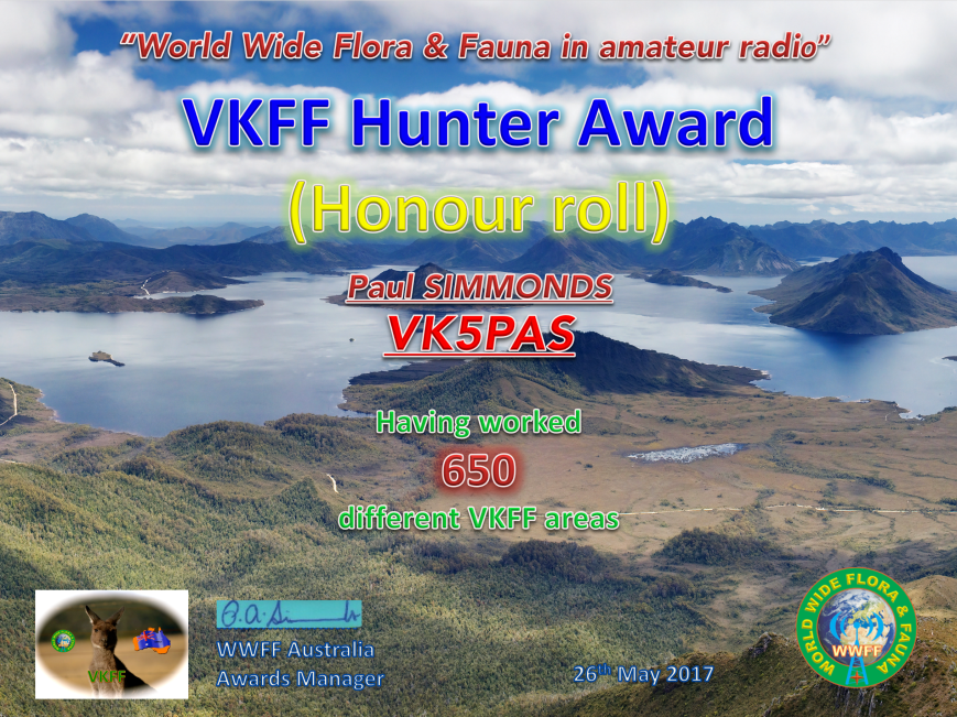
Today I received my latest VKFF Hunter Honour Roll certificate. The certificate is issued for working a total of 650 different VKFF references.
Many thanks to all of the VKFF activators.

Today I received my latest VKFF Hunter Honour Roll certificate. The certificate is issued for working a total of 650 different VKFF references.
Many thanks to all of the VKFF activators.
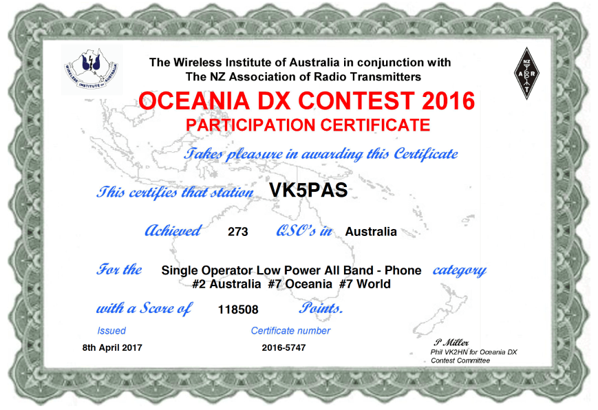
In the past few days the results for the 2016 Oceania DX Contest has been released. I entered into the Single Op/Low Power/All Bands/Phone section. I made a total of 273 QSOs and came second in Australia in this section, 7th in Oceania, and 7th in the World.
Many thanks to the Oceania DX Contest Committee.
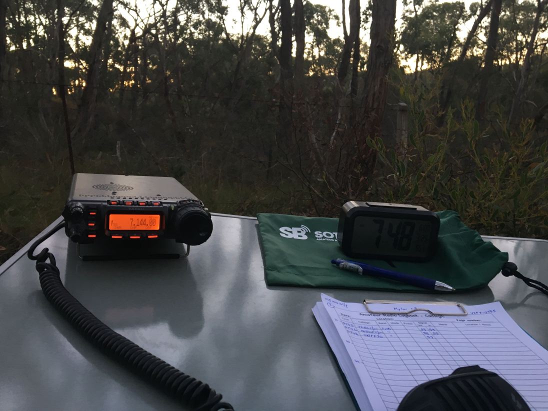
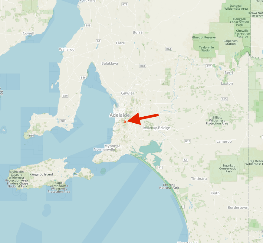
Late on Sunday afternoon (21st May 2017) proceedings had started to slow down a little, and I had a small window of time to head out to a park and operate as VI5WOW before the scheduled 6.00 p.m. BBQ tea at the Hahndorf Oval. I decided on Mylor Conservation Park 5CP-156 & VKFF-0785, as it is just a short drive from Hahndorf.

Map showing the location of the Mylor Conservation Park in the Adelaide Hills. Map courtesy of Protected Planet.
Mylor Conservation Park was proclaimed on the 27th day of February 1997. While most of the land around the park has been cleared for residential and agricultural purposes, the park preserves an important area of remnant bushland. The park is mostly Open Forest with Candlebark Gum, Brown Stringybark, Messmate Stringybark, Cup Gum, Pink Gum and Manna Gum. Understory plants include Myrtle Wattle , Spiny Wattle, Narrow-leaf Bitter-pea, Large-leaf Bush-pea and Silver Banskia.
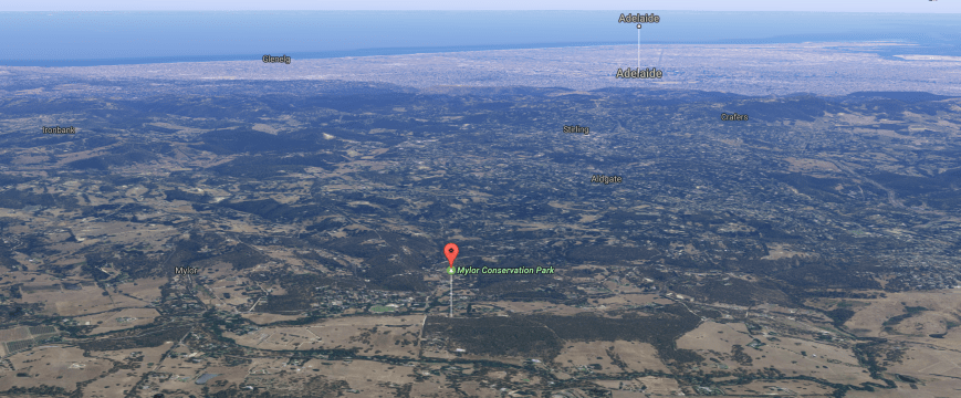
Aerial shot of the Mylor Conservation Park, with Adelaide in the background. Image courtesy of Google maps
The park takes its name from the nearby small town of Mylor which was proclaimed in 1891 by Acting Governor of South Australia, Sit James Boucaut who named it after his Cornish birthplace.

Sir James Penn Boucat (1831-1916). Image courtesy of Wikipedia
There is a 2.3 km track winding through the park which is rated as ‘challenging’ and will take you around 2 hours to complete.
The park is home to a large amount of native wildlife including Western Grey kangaroos. More than 50 species of bird have been recorded in the park including Adelaide Rosella, White-throated Treecreeper, Superb Fairywren, Grey Fantail, and the Australian Golden Whistler.
I set up in my normal operating spot off Whitehead Road and Centre Track which is part of the Heysen Trail.
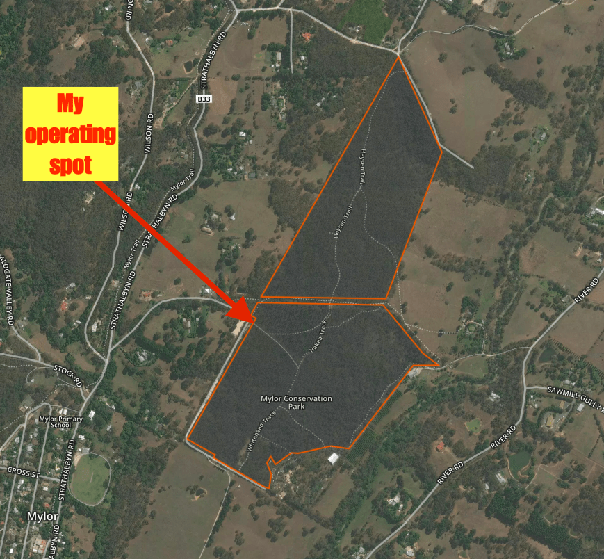
Aerial shot of the Mylor Conservation Park showing my operating spot. Image courtesy of Protected Planet.
I ran the Yaesu FT-857d, 40 watts and the 80/40/20m linked dipole for this activation. I was set up and ready to go by just after 0710 UTC (4.40 p.m. South Australian local time). I had around 60 minutes of on air time before I needed to pack up.
My first contact was on 7.144 on the 40m band with Steve VK4QQ. This was followed by Phil VK3GTS, Cliff VK2NP, Gerard VK2IO and then Colin VK4PDX. All had good strong signals ranging from 5/8-9. The band appeared to be in pretty good shape.
I had contact number 10 in the log in around 9 minutes, this being with Matt VK3FORD. Contact number 44, with Ian VK1DI, was reached in around 45 minutes. I worked a total of 52 stations on 40m from VK2, VK2, VK3, VK4, VK5, VK6, and VK7, including a Park to Park contact with Nikolas VK3NLK who was operating portable in the Tocumwal Regional Park VKFF-0978.
To finish off the activation I headed to 3.610 on the 80m band where I logged just 4 stations from VK3, VK5 and VK7. Sadly I was really pushing for time and needed to go QRT.
So in around one hour in the park I had logged a total of 56 stations. Hopefully I gave people another good contact towards the special 2017 AGM/Convention Award.
I worked the following stations on 40m SSB:-
I worked the following stations on 80m SSB:-
References.
Birds SA, 2017, <http://www.birdssa.asn.au/location/mylor-conservation-park/>, viewed 26th May 2017
National Parks South Australia, 2017, <https://www.environment.sa.gov.au/parks/Find_a_Park/Browse_by_region/Adelaide_Hills/mylor-conservation-park>, viewed 26th May 2017
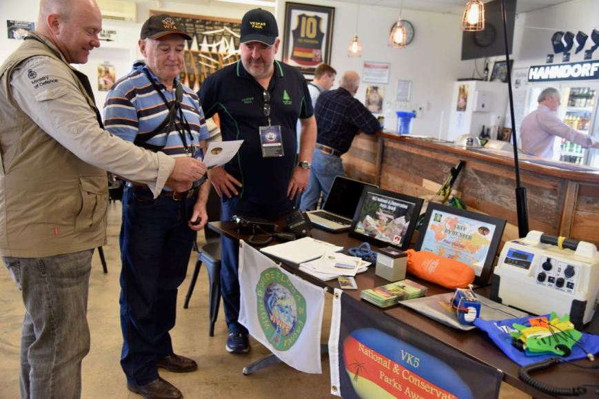
After packing up at Mark Oliphant Conservation Park I headed back to the Hahndorf Oval, where with the assistance of Chris VK5FR we set up a small display table promoting WWFF and the VK5 National & Conservation Parks Award. This was as part of the Come and Try Day for the 2017 WIA AGM/Convention.
At the parks display table
We had a number of transceivers on display including the Yaesu FT-857d, Elecraft KX3, and the Yaesu FT-817nd. Also numerous power sources, squid poles, antennas, and other surplus equipment. Our WWFF & VK5 Parks Award handouts diminished as the afternoon went on.
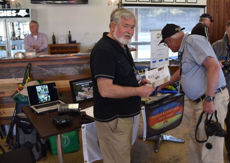
Robbie VK5FRSM & Tony VK5ZAI at the display
Many thanks to Chris VK5FR for lending a hand, and thanks to those who stopped by for a chat and showed interest in the display.
On Sunday morning (21st May 2017), myself and four other team leaders had planned to take a number of people out into the field to activate South Australian parks as part of the 2017 WIA AGM & Convention. The team leaders and parks comprised…..
John VK5BJE and his team headed direct to Scott Creek, while Chris VK5FR and his team headed to Cleland. The remainder of us met outside the Gums Bistro at Hahndorf at 9.00 a.m. and departed from there.
I had three people in my group…..
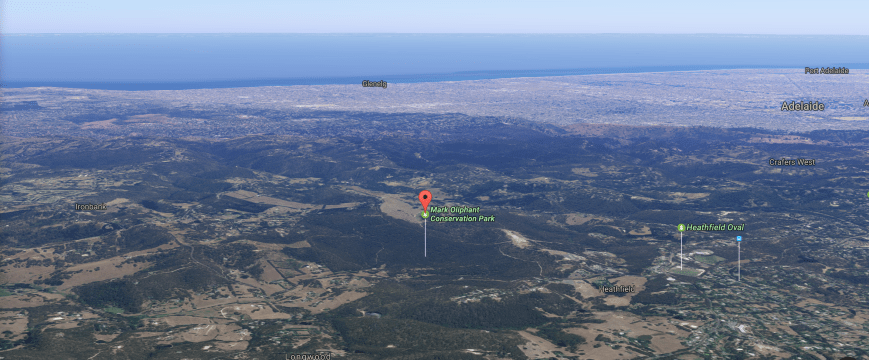
Our park was to be the Mark Oliphant Conservation Park 5CP-127 & VKFF-0782, which was a short 20 minute drive from Hahndorf. The park is about 2 km south east of Adelaide.
Map showing the location of the Mark Oliphant Conservation Park east of Adelaide. Map courtesy of Protected Planet.
Mark Oliphant is 189 hectares in size and features tall forest trees and spring wildflowers. The park is typical of an Adelaide Hills forest environment and features medium and steep sloping hillside, rounded ridge tops and narrow valley floors.
Aerial shot of the park, with Adelaide in the background. Image courtesy of Google maps
Messmate stringybark and brown stringybark dominate the forest canopy in the park. There is a small stand of candlebark gums near the old oval. This tall eucalypt with white bark is rare and only found in the higher rainfall areas of the Adelaide Hills. Tiny patches of pink gum, manna gum and blue gum also occur in the park.


The park was first used for recreation during the 1930’s and was purchased by the Young Men’s Christian Association of Adelaide Incorporated (YMCA) in 1945. In 1953 it was acquired by the South Australian State Government and was used as a National Pleasure Resort. In 1972 the park was proclaimed as the Loftia Recreation Park. In 1992 and again in 1995, the park was expanded. In 1996 the park was renamed in honour of former State Governor Sir Mark Oliphant’s contribution to conservation.

From the Adelaide Advertiser, Tue 19 Feb 1952. Courtesy of Trove
Sir Marcus Laurence Elwin ‘Mark’ Oliphant (1901-2000) was an Australian physicist and humanitarian who played an important role in the first experimental demonstration of nuclear fusion and also the development of nuclear weapons.

Sir Marcus Laurence Elwin ‘Mark’ Oliphant. Image courtesy of Wikipedia.
The park is home to large amount of native wildlife including the nationally endangered Southern Brown Bandicoot and the rare Yellow Footed Antechinus. Over 70 species of bird have been recorded in the park including the Superb Fairy Wren, Scarlet Robin, Golden Whistler, Adelaide Rosella, Crescent Honeyeater, Yellow-faced Honeyeater, and Grey Fantail.
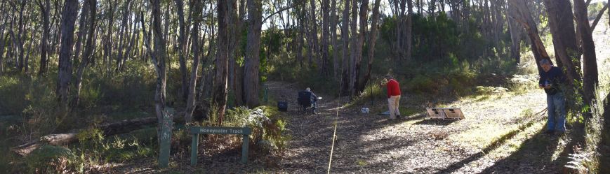
We set up in my normal operating spot, on Honeyeater Track on the northern side of Evans Drive. This is in a high position in the park and there is plenty of room to string out a dipole.
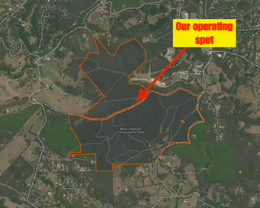
Aerial shot of the Mark Oliphant Conservation Park showing our operating spot. Image courtesy of Protected Planet.
It was an absolutely beautiful sunny morning and was had indeed been blessed by the weather gods. For this activation I ran the Yaesu FT-857d, 60 watts output and the 80/40/20m linked dipole, inverted vee, supported on the 7m heavy duty telescopic squid pole.
Gerard VK2JNG was up first and had soon qualified the park for VKFF, with in excess of 10 QSOs in the log. Cliff VK2NP was number one in the log. Gerard commented to me that he had been bitten by the portable bug, so I expect to hear Gerard on air from parks in the near future. Gerard’s tally included 2 Park to Park contacts; Chris VK3PAT in Cape Conran Coastal Park VKFF-0744m and Ivan VK5HS in the Pike River Conservation Park 5CP-180 & VKFF-0831.


Next up was Al VK2OK. Everyone seemed to have come out of the woodwork, and it wasn’t long before Al was managing a mini pile up. Al very very quickly qualified the park for VKFF, making a total of 20 contacts including numerous Park to Park QSOs.


Meanwhile, Stuart VK3STU was making contact with other park activators on 20m simplex.

Stuart VK3STU making 2m handheld contacts
Just before midday Gerard and Al left to head back to the oval at Hahndorf. Stuart VK3STU took the opportunity of getting onto 40m and 80m, making a number of contacts and well and truly qualifying the park. Stuarts tally was 23 QSOs with 11 Park to Park contacts.
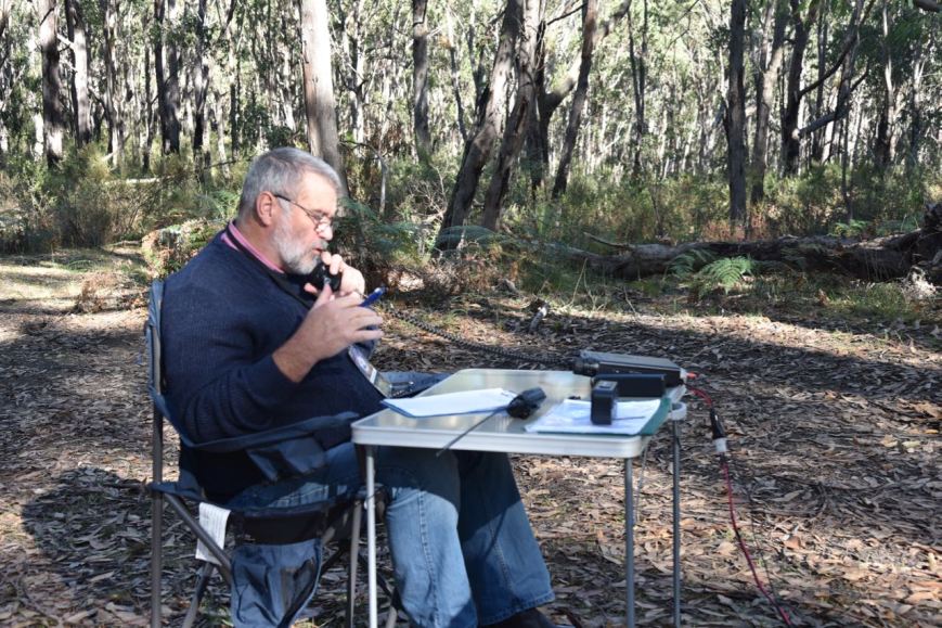
Stuart VK3STU on 40m
I also squeezed in 20 minutes from the park as VK5WOW.
It was great morning out, with many positive comments about operating portable from parks. Hopefully we have recruited a few more park activators and hunters to the ranks. Thanks to the team leaders and participants. And thanks to everyone who called.
I worked the following stations as VK5WOW on 40m SSB:-
References.
Birds SA, 2017, <http://www.birdssa.asn.au/location/mark-oliphant-conservation-park/>, viewed 25th May 2017
Department of Environment and Natural Resources, 2010, ‘Mark Oliphant Conservation Park’.
National Parks South Australia, 2017, <https://www.environment.sa.gov.au/parks/Find_a_Park/Browse_by_region/Adelaide_Hills/mark-oliphant-conservation-park>, viewed 25th May 2017
Wikipedia, 2017, <https://en.wikipedia.org/wiki/Mark_Oliphant>, viewed 25th May 2017
An amazing weekend has come and gone…..the 2017 Wireless Institute of Australia (WIA) Annual General Meeting (AGM) and Convention in Hahndorf, South Australia. The theme for this year was….
Firstly I would like to congratulate the very hard working AGM/Convention Organising Committee, which comprised members from the various amateur radio clubs in Adelaide:
I was not part of the Committee, but was incorporated in their email group, and as a result I know of the tireless hours that the Committee put in behind the scenes to organise what was a sensational event. They can all take a bow and be very proud of what was achieved. They certainly made South Australia very proud.
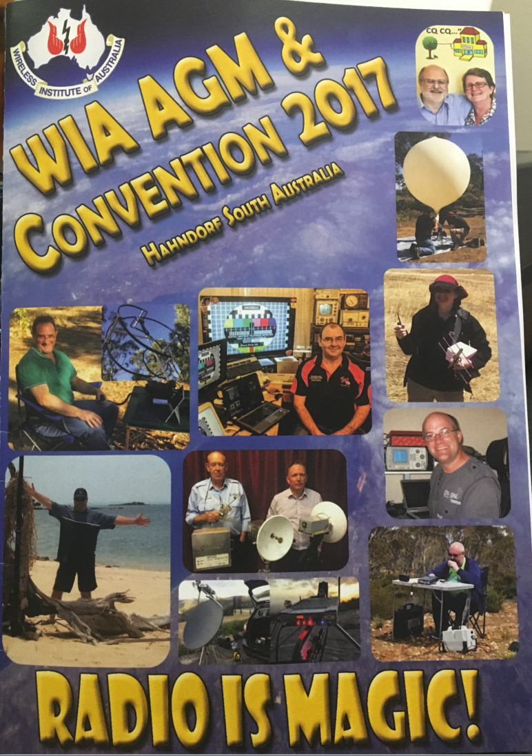
Hahndorf is a small town situated in the Adelaide Hills, about 28 km south east of Adelaide. It is just a short 7 minute drive from my home. Hahndorf is classified as Australia’s oldest surviving German settlement, and each year, tens of thousands of tourists flock to Hahndorf’s main street which features historic hotel, restaurants & cafes, craft shops, lolly shops, smallgoods outlets, and bakeries.


For my wife Marija VK5FMAZ and I, the proceedings commenced late on Thursday afternoon, with Heath VK3TWO and his wife Monique VK6FMON arriving at our house. Heath and Monique had arranged to stay with us during their visit. Peter VK3PF was also scheduled to arrive, but was activating some parks along the way. Marija, Heath, Monique and I headed out for tea at the local Auchendarroch House and got back home around 8.30 p.m. Peter arrived soon after we got home and we all enjoyed a few nightcaps.
On Friday morning (19th May 2017) I headed off to work early, so that I could finish early. Upon completing work I headed down to the airport and collected Andrew VK6AS. We headed back to Hahndorf and caught up with David VK5KC and John VK5BJE for a coffee at the Three Gums Bistro. A group of us then headed down to the Hahndorf Inn in the Main Street of Hahndorf for a few traditional German beers.
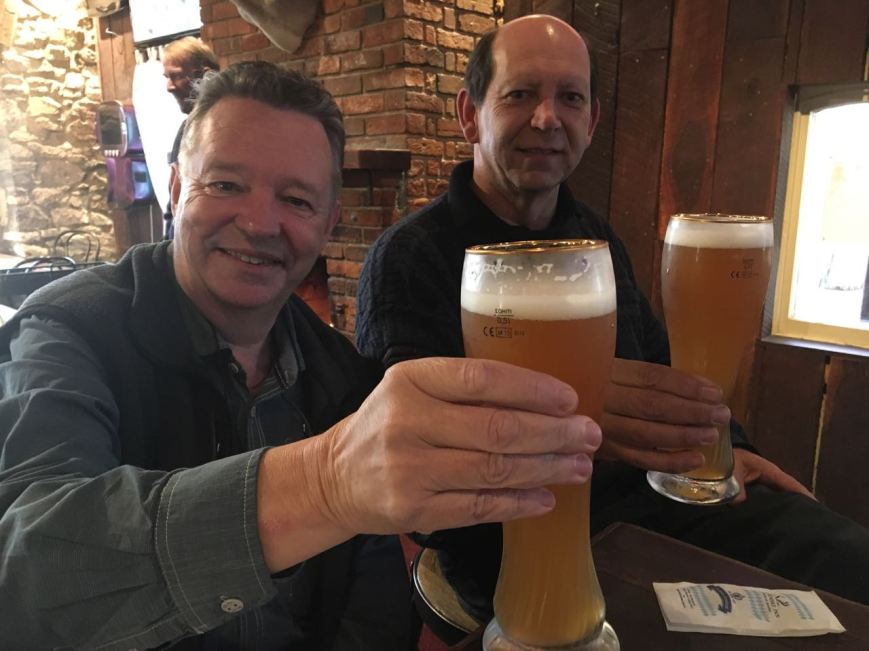
Andrew VK6AS & Ian VK3BUF enjoying a German ale
A little later that evening we attended the Friday night festivities which were held at the Hahndorf Convention Centre. The evening was very well attended and featured all you can eat gourmet pizza. It was a fun evening and it was terrific to catch up with a number of familiar faces, and meet a few new people.


On Saturday morning we all headed for the AGM, Forum, and presentations which were held at the Hahndorf Convention Centre. Forgetting the politics of the AGM, the day was a huge success. The new WIA Board were welcomed in, and I certainly wish them very well for the future.
Guest speakers in the afternoon were:


During the day, Doc VK5BUG officialy launched his new book ‘Cellar Dwellars in the Go – operating 22200m, 630m, and 160m away from home’.
Whilst enjoying the Forum and talks at Hahndorf, many others chose the Partners Tour on the Saturday which featured two separate tours: a trip to the world famous Barossa Valley wine growing region, and a Mount Lofty Ranges tour.
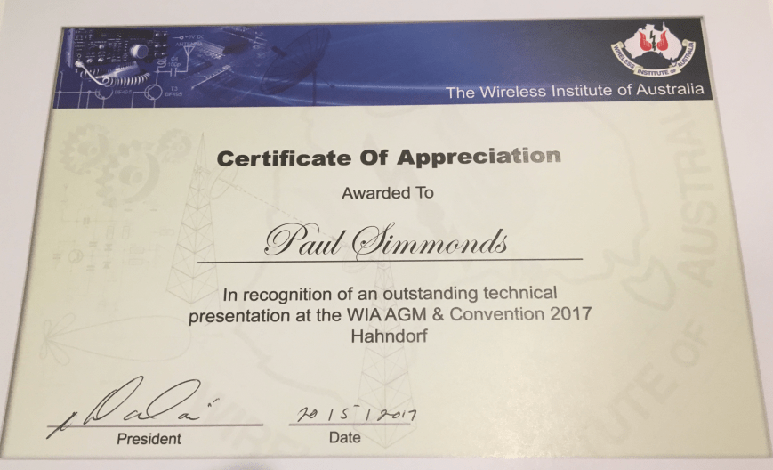
All of the presenters were kindly given a certificate of appreciation, $50.00, and a nice bottle of red.
Later that evening we attended the Convention dinner which was held at the Hahndorf Convention Centre. The keynote speaker was Craig VK5CE who gave a very interesting presentation on his exploits in the Islands on the Air (IOTA) program. It was a thoroughly enjoyable and at times humorous presentation. Craig certainly opened a few eyes on how challenging operating from islands can be. Sue VK5AYL also spoke on her newly released Parks and Peaks App for iPhone which I have since used and it is great.


On Sunday morning, with a slightly sore head from the night before, I headed back to Hahndorf where I met up with a keen group of amateurs who we had arranged to take out in the field. For many it was to be their very first park activation. There were five teams, headed by John VK5BJE, Chris VK5FR, Les VK5KLV, and Peter VK5PET, and myself. We each had about 3 participants in each team.
The following parks were activated:
My three keen park activators were Stuart VK3STU, Al VK2OK, and Gerard VK2JNG. All 3 qualified the park for VKFF and appeared to have been bitten by the ‘portable bug’. I also gave VK5WOW a 20 minute run from the park.


Whilst some took up the opportunity of park activating on Sunday morning, others chose the trip to the National Motor museum at Birdwood. About 60 people attended the museum.
Just after midday I headed to the Hahndorf oval where the Come and Try amateur radio day was being held. With the help of Chris VK5FR, we set up a small display table on operating portable from a park. The display table included a number of transceivers, antennas, power sources, certificates, etc. Lots of questions were thrown at us from budding park activators.
Other displays and demonstrations at the oval included:-


The Amateur Radio Experimenters Group (AREG) launched a Project Horus high altitude balloon which contained a number of payloads, including 2m/70cm repeater. This was certainly one of the highlights of the afternoon.


Joe VK3YSP and Julie VK3FOWL also kept a large group of children from the local Hahndorf Primary School enthralled with a number of activities. It was great to see the kids having a lot of fun. Who knows, some of them may go on to becoming amateurs. Well done Joe and Julie.
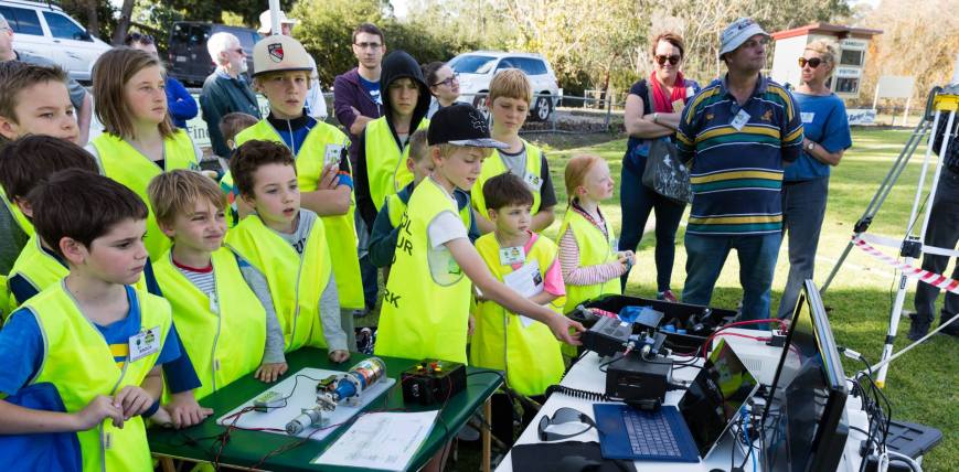
Children from the Hahndorf Primary School. photo courtesy of Stuart VK5STU
Late in the afternoon I had a little bit of time to kill before the 6.00 p.m. BBQ tea at the oval. So I headed down to the Mylor Conservation Park and put VI5WOW on air for around an hour and logged a further 54 contacts from around Australia.


I then headed back to the Hahndorf Oval for the evening BBQ, which was the last hooray for the weekend. On Monday morning, I bidded farewell to Heath & Monique, and Peter, and headed to Hahndorf where I collected Andrew VK6AS and dropped him at the airport. It was the end of a truly MAGIC weekend. Again, thanks to all those involved.
Don’t forget that all contacts with VK5WOW and VI5WOW count towards the special 2017 WIA AGM/Convention Award, which can be applied for on-line via the WIA on-line awards system.
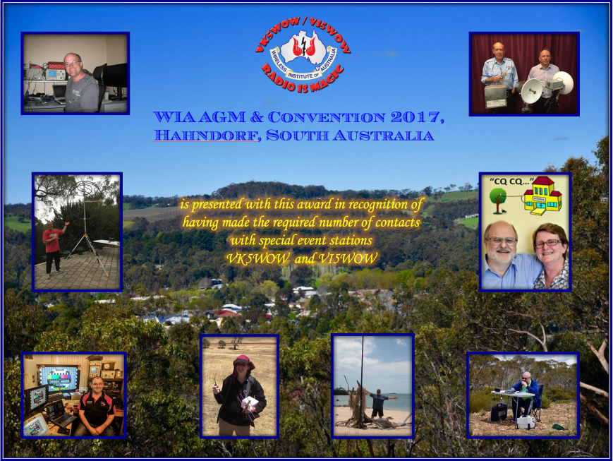
During the past couple of weeks I have had a terrific time using the VK5WOW and VI5WOW calls for the upcoming Wireless Institute of Australia (WIA) AGM and Convention in Hahndorf, South Australia.
I would like to thank the North East Radio Club and the WIA Organising Committee for allowing me use to these calls.
Remember that all contacts with VK5WOW and VI5WOW count towards the special 2017 AGM & Convention Award.

I activated 6 parks for the VK5 National and Conservation Parks Award & World Wide Flora Fauna (WWFF), and one mill for the recent Mills on the Air Weekend. I made a total of 841 contacts.
Here is a breakdown of my activations……


THANKYOU to everyone who called.
Yesterday afternoon (Wednesday 17th May 2017) I finished work at 3.00 p.m. local time and headed the short distance back home to collect my radio gear. It was a miserable afternoon, with shower activity all day. I had planned to activate the Mount George Conservation Park 5CP-147 & VKFF-0784 as VK5WOW/p, and despite the poor weather, I decided to continue with the park activation.
Mount George CP is just a short distance from my home, about a 10 minute drive. The park is situated about 21 km south east of the city of Adelaide.

Map showing the location of the Mount George Conservation Park in the Adelaide Hills. Map courtesy of Protected Planet.
Mount George Conservation Park was proclaimed on the 7th November 1996 and conserves 85 hectares of important native vegetation in the Mount Lofty Ranges ‘Adelaide Hills’. The park was originally 67 hectares in size before the boundaries were extended in 2003, adding a further 18 hectares. The park is characterised by steep slopes adorned with Stringybark Open Forest. The State endangerd Mountain Gum can be found in the park. The park also contains creeks, wetlands, and freshwater bogs. The Mount George summit, 520 metres, is located within the park. Sadly it does not have the required prominence for the Summits on the Air (SOTA) program.

Aerial shot showing the Mount George Conservation Park, with Adelaide in the background. Image courtesy of Google Maps
I set up in my normal operating spot, the carpark at the end of Mount George Road, where there is a picnic ground. With the help of my wife Marija, who had popped in on her way home from work, I set up the annexe of the Toyota Hi Lux. As this was to be a VI5WOW activation, I needed to operate under the conditions of the VK5 National & Conservation Parks Award, which does not allow me to operate from inside the vehicle.
I ran the Yaesu FT-857d, 40 watts, and the 80/40/20m linked dipole for this activation.
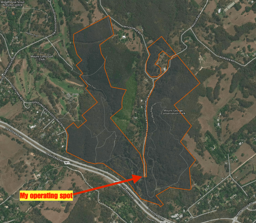
Aerial shot showing my operating spot in the park. Image courtesy of Protected Planet.
I headed to my nominated operating frequency of 7.144 on the 40m band. My first contact was with Les VK5KLV at Port Augusta with a good 5/8 signal. This was a little down compared to normal. I generally receive Les 5/9. This was followed by Peter VK3TKK mobile, Rick VK4RF/VK4HA, and then Steve VK4QQ. Band conditions seemed to be down compared to normal, and it was quite slow going. I reached 10 QSOs, qualifying the park for VI5WOW for VKFF, in around 14 minutes.
The showers had not let up, but the annexe of the Hi Lux provided good cover. Marija headed back home to collect the side awning, which we had left out of the vehicle.
I worked a total of 39 stations on 40m from VK1, VK2, VK3, VK4, VK5, VK6, and VK7. Local propagation was virtually non existant, with just 4 South Australian stations in the log. Three of those were in close proximity to Mount George, so signals being via ground wave. It was nice to make the trip all the way over to Western Australia, with Rich VK6HRC and Jarrad VK6FFAR logged. I also spoke with Peter VK3PF/p who was activating SOTA peak Mount Dundas VK3/ VS-045.

My operating spot, sheltering from the rain.
Just before 5.30 p.m. local time I headed off to the 80m band. I didn’t bother trying 20m as I had left my run a little too late. I called CQ on 3.610 and this was answered by Colin VK4PDX who had followed me down from 40m. I was then called by Adrian VK5FANA on the Yorke Peninsula, Hans VK5YX and Mike VK5FMWW in the southern suburbs of Adelaide, and then Bill VK5MBD at Red Hill in the Mid North of the State. I logged a total of 28 stations on 80m from VK1, VK2, VK3, VK4, and VK5.
I then headed back to 7.144 on 40m and worked Bruce VK2HOT who had followed me up from the 80m band, followed by Mark VK4SMA, and then Marija VK5FMAZ. But it was very very slow going, with very few callers.
At 0930 UTC I booked in to the 7130 DX Net. Sadly, band conditions were absolutely awful, and I could only hear a handful of stations. I remained on the net, for just one round, logging Brian ZL2ASH and George VK4GSF.
At the request via Facebook of a few VK5’s, I then headed back to 80m. It was still wet and cold, and I didn’t plan on hanging around for long. I logged a further 9 stations from VK3, VK5, and VK6, before going QRT.
I had a total of 84 contacts in the log.


I worked the following stations on 40m SSB:-
I worked the following stations on 80m SSB:-
References.
Department for Environment and Heritage, 2006, Mount George Conservation Park Management Plan.
On Sunday morning (14th May 2017), Mother’s Day, my wife Marija, my mother in law, and my son and his girlfriend, and my daughter, all headed out for a late breakfast at the local cafe. It was a great morning, celebrating Mother’s Day. Marija and her mum had planned to go shopping that afternoon, so I decided to head down to Strathalbyn to activate the Old Laucke Flour Mill for the Mills on the Air Weekend.

Strathalbyn is located about 57 km south east of Adelaide, and is situated on the banks of the Angas River.

Map showing the location of Strathalbyn, south east of Adelaide. Map courtesy of Google Maps.
Strath Albyn is derived from two Gaelic words – ‘strath’ meaning ‘broad valley’ or a ‘valley with a river running through it’ and ‘Albion’ meaning ‘hilly land’. The town has more than 40 heritage listed buildings, including St Andrews Church which overlooks the Soldiers Memorial Gardens and the river.
And another one of those historic buildings is the old flour mill which was built by Donald Gollan in 1849. It located on the corner of Commercial Road and Hill Street in the centre of Strathalbyn. It is a four storeyed rectangular building which was constructed of random rubble walls with dressed stone quoins at corners and openings. The roof is corrugated iron hip and skillion design on timber framing. Gollan sold the mill to William Coleman in 1850/1851. Coleman was aprominent figure in Strathalbyn’s municipal history, and he oversaw the mill as it received grain from the flourishing agricultural hinterland of Strathalbyn.
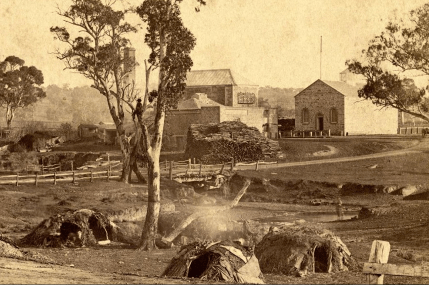
The flour mill and grain store, c. 1840’s, with an aboriginal camp in the foreground. Image courtesy of http://www.aussietowns.com.au
The mill was subsequently run by the Johnston family from 1883 until 1928 when it was sold to the Laucke family. The old mill was replaced in 1961 with a newly built mill just down the road at Strathalbyn. Laucke is still a very well known name in the milling industry and are renowned internationally for the production of a wide range of high quality flours for the food industry and home bakers.


Above:- Eary images of Laucke Flour Mill. Courtesy of http://www.laucke.com.au
A very interesting video on Laucke Flour Mills can be found at the ABC’s Landline website. Here is the link……
Directly opposite the old mill is the former Coleman’s Grain Store which was built by William Coleman in 1869 as the store for the Angas Mill. The building also served as a hall for dances and public meetings prior to the construction of the Institute (now Town Hall), and later as a site for agricultural shows when the land to the north was the showgrounds. It is a simple rectangular building with one large room, gable ends, round headed windows and a door placed centrally in the main gable facade. It is constructed of random rubble walls, without quoins, tuck pointed on two street facades. A small tram line crossed the road to the mill.


Strathalbyn has been in the news a bit over recent years due to a huge problem with the Little Corella population. They have destroyed significant vegetation within Strathalbyn including the pine trees around the Angas River. And they, along with Sulphur Crested Cockatoos were quite active during my activation.


I set up right alongside the mill. I ran my normal portable station for this activation, consisting of the Yaesu FT-857d, 40 watts output, and the 20/40/80m linked dipole supported on the 7 m telescopic squid pole, inverted vee configuration.
Much to my pleasure, when I turned the transceiver on, the noise floor was pretty good considering I was in the heart of town. The noise was around strength 5. I commenced the activation by calling CQ on 7.095. Number one in the log was Sergio VK3SFG who has become a regular park hunter during my park activations. This was followed by Brian VK3BBB and then my wife Marija, who not surprising was 5/9 ++ on ground wave.
Contact number 11 was with Mark VK4SMA who was portable in the Mogill Conservation Park VKFF-1594 in Queensland. Nine QSOs later I was called by Jonathan VK7JON and his wife Helen VK7FOLK, who were activating the Hellyer Gorge State Reserve VKFF-1139 in Tasmania. Next up was David VK3BI who was operating portable at Andersons Mill at Smeaton in Victoria. It was nice to get a Mill to Mill contact.
I logged a total of 39 stations on 40m from VK2, VK3, VK4, VK5, and VK, before heading off to 14.310 on the 20m band. Much to my surprise, Ivan UR9IDX in Ukraine came back to my call with a strong 5/8 signal. I was quite excited, hoping that more Europeans would follow. But sadly that was not to be the case. Ivan was my only European caller. And in fact he was my only caller full stop. Five minutes of CQ calls yeilded no takers. So I QSY’d down to the ANZA DX Net, where I booked in and logged 4 stations, including Jim WA4YBC in Georgia, USA, and Joe K5KT in California, USA. When the net wrapped up I tuned across the 20m band and logged Mario 9A7C in Croatia.


I then headed to 3.610 on the 80m band, hoping to log some of the South Australian stations. But unfortunately Adrian VK5FANA on the Yorke Peninsula was my only caller, despite Adrian spotting me on parksnpeaks and me placing my frequency on some of the Facebook sites.
I then put a phone call in to Tony VK5MRT, a local Strathalbyn resident, and mate of mine, and invited him down to pay me a visit and get on air. Whilst waiting for Tony to arrive I headed back to 7.095 on the 40m band and called CQ. I logged 4 further stations before Tony arrived, and we swapped the mic. Tony had soon filled up 3/4’s of his log sheet which was great.


After spending about 45 minutes on air, Tony headed off, and I jumped back into the ‘driver’s seat’ and called CQ on 7.095. I was very pleased, as there was no shortage of callers. I had soon logged a further 33 stations, including Oliver ZL1XS in New Zealand.
It was now 5.40 p.m. and the sun was disappearing fast. And with that, so did the temperature. It had dropped down to 7 deg C. I decided to give 80m one last quick go and I’m pleased I did, as I logged special event station VI5WOW, with Steve VK5SFA on the mic. And also my good wife Marija VK5FMAZ.
I had enjoyed another great day out in the field with a total of 87 stations in the log on 20, 40 & 80m SSB. It seems that Mills on the Air activity may be on the increase here in Australia, which is great news. Any activity which creates more activity on the amateur bands is a good thing.
I worked the following stations on 40m SSB:-
I worked the following stations on 20m SSB:-
I worked the following stations on 80m SSB:-
References.
Aussie Towns, 2017, <http://www.aussietowns.com.au/town/strathalbyn-sa>, viewed 15th May 2017
District Council of Strathalbyn, 1985, ‘Heritage Survey of the Fleurieu Peninsula’
Laucke, 2017, <http://www.laucke.com.au/>, viewed 15th May 2017
After leaving Nixons Mill at Hahndorf, I made the short journey to the Kenneth Stirling Conservation Park 5CP-104 & VKFF-0781. The park is situated about 17 km east of Adelaide, in the Mount Lofty Ranges ‘Adelaide Hills’.
Map showing the location of the Kenneth Stirling Conservation Park. Map courtesy of Protected Planet.
I have activated Kenneth Stirling under my own call, five times previously. For more information on those activations, please see my previous posts…..
https://vk5pas.org/2016/04/19/kenneth-stirling-conservation-park-5cp-104-and-vkff-0781/
https://vk5pas.org/2015/04/09/kenneth-stirling-conservation-park-vkff/
https://vk5pas.org/2015/01/24/kenneth-stirling-conservation-park-3/
https://vk5pas.org/2014/07/11/kenneth-stirling-conservation-park-2/
https://vk5pas.org/2013/05/10/kenneth-stirling-conservation-park/
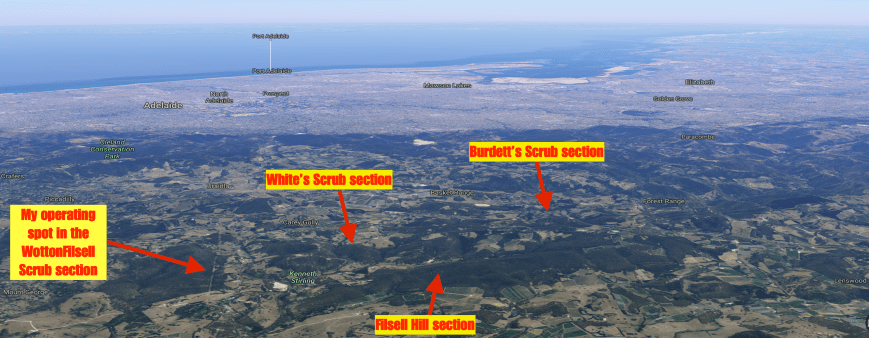
Kenneth Stirling Conservation Park is quite a unique park in that it consists of four autonomous sections:
The total size of Kenneth Stirling is 253 ha, comprising mostly stringybark forest with some gum woodland. The park was established in 1985 with the purchase of two sections of land, Filsell Hill at Forest Range and Wotton’s Scrub at Carey Gully. Further land adjoining Filsell Hill was subsequently purchased with a bequest from Miss Anne Steer. In 1986 White’s Scrub was donated by Mr. and Mrs. Vern White, whilst in 1989 the Burdett family donated the northern most section.
Aerial shot showing the 4 sections of the park in the Adelaide Hills, with the city of Adelaide in the background. Image courtesy of Google maps
The park is named in honour of Kenneth George Stirling. Although I have spoken about Mr. Stirling in my previous posts, he is well worth highlighting again, as he was certainly an outstanding individual. Some time ago when researching the park I spoke with Graham Churchett, who knew Kenneth Stirling. This is what Graham had to say:
“The Environment Committee was a sub committee of the Town and Country Planning Association composed of the following:
Ron Caldicot, Dr John Coulter, David Strahle, Alwin Clements, Ray Holliday, Miss Erdley, Dr Peter Guldhurst, Ken Stirling, Ralph Middenway, Elise and Gordon Gardner and myself.
This committee was active across a broad spectrum of planning and environmental issues but it was not until money was given anonymously to the committee, and we employed Ron Caldicot as a Project Director, that some monumental changes occurred.
At the time the State Planning Authority was headed by Stewart Heart and sitting on the authority were developers and others who naturally pushed through every approval to further line their pockets at the expense of the environment and common good. The committee pressured the government and Ron was appointed to the Authority and in a short time the rules were changed to exclude those with vested interests.
With the help of the Natural History Society we brought about the protection of the wedge tail eagle, and Improved planning laws.
In May 1980 tragedy occurred. David Strahle, a gentle, dedicated man and one who worked for a better world suddenly died due to a massive heart attack. We were all stunned, he was only in his 45th year.
In 1973 we were again shocked when Ken Stirling died from a heart attack when jogging by the uni bridge. He was only 38.
Ken, and all of us for that matter, were appalled at the scarring taking place in the north Flinders by EX Oil and Ken knew more of what was going on as he was employed by two of Australia’s largest mining companies before joining Poseidon’s associate, Samin Ltd, in 1969.
It was when Poseidon shares went through the roof that Ken became a millionaire and in 1972 Ken resigned from the mining industry and sought a position in the Public Service with the Department for the Environment. A series of applications were rebuffed and some were not even answered and he was bitter at this.
While waiting for something to turn up he gave unpaid service to the Birdwood Mill Museum.
His benefactions were not known to the Public service and his intense interest in conservation not realised.
Those who examined his application may have noted with disapproval his association with the mining industry. The irony of it is that but for the mining boom, the entire conservation cause in South Australia would not have prospered without Ken’s personal service and financial help.
It was only after his death we found out that Ken had given money to a variety of organisations and in particular, for Ron’s full time employment as a director, $100.000 was given to set up Radio 5UV University radio employing Keith Conlon. $50,000 was given to State Archives, $200,000 to the Australian Conservation Foundation for the acquisition and establishment of a national park. This park is now rightly known as the Kenneth Stirling Conservation Park.
Through Ron we achieved so much and it was then that I came to the earnest belief that if the conservation movement was to make any meaningful headway in this cockeyed world, we had to employ key people full time.
I was privileged to have known Ron, David and Ken as friends, all be it that our time together with regard to David and Ken was short. I was saddened to hear the other day that Ron, a man I knew with a mind as sharp as a tack and a gentle manner but one who would stand his ground with great conviction, was now in a home suffering severe dementure.
What can I say other than they are fondly remembered.”
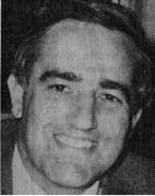
Below is part of what the Advertiser columnist, Stewart Cockburn said of Ken Stirling upon his death…..
“Ken Stirling was the son of a railway man. He wanted to be a boundary rider on an outback station and, for a while, he became a multimillionaire. He made his money in the mining boom, and gave most of it away. Only since he died, have the benefactions of this humble, intensely private man become known outside his family and a small circle of friends and associates.”
The park has an active Friends of Kenneth Stirling group. Their site can be located at…..
http://www.friendsofparkssa.org.au/members-directory/friends-of-kenneth-stirling
![]()
On my way to the park I spoke with VK5ALM who were activating the Dunn Mill at Mount Barker. They had a nice signal into the mobile. Once arriving at the park I set up in my normal operating spot, in the Wotton Scrub section of the park, off Gum Flat Road.

Map showing the 4 sections of the Kenneth Stirling CP, and my operating spot. Map courtesy of Protected Planet.
I headed for 7.144 and asked if the frequency was in use. Joe VK3YSP was waiting there for me and was number one in the log. This was followed by Julie VK3FOWL, Geoff VK3SQ, and then Peter VK3HSB. It didn’t take long for the pile up to ensue, with contact number 50 in the log after being on air for about 40 minutes. All signals were very good. I also had a European park activator on the frequency as well, who sadly could not hear me.
After logging a total of 56 stations from VK1, VK2, VK3, VK4, VK5, VK6, VK7, and New Zealand, I headed to the 20m band. I tuned to my normal operating frequency of 14.310 and heard Rick VK4RF working Mike 2E0YYY/p on a SOTA peak in the United Kingdom. Unfortunately I could not hear Mike on this occasion. I moved up to 14.315 and called CQ, and was soon called by Rick VK4RF who had tracked me down.
I logged a total of 8 stations on 20m. This included VK5ALM at the Dunn Mill at Mount Barker. Only one DX station was logged, that being Gerard F1BLL in France. Sadly, the long path propagation to Europe was virtually non existant.


I then moved back to 7.144 where I logged a further 27 stations from VK2, VK3, VK4, VK5, VK6, VK7, USA, and New Zealand. I was very pleased to give Martin VK3FMJP and Chris VK5SA their 5th contact with VK5WOW, thus qualifying them for the special 2017 WIA AGM/Convention Award. And I was extremely happy to log Mark AF6TC in the USA, who was booming in at 5/9 +.
To finish off the activation I headed off to 3.610 on the 80m band. It was now 5.30 p.m. local time and starting to get dark. It was also now getting very cold. The temperature had dropped down to 7 deg C. I logged a total of 16 stations on 80m from VK2, VK3, VK5, and VK7. And I made it three stations that had worked VK5WOW a total of 5 times, with Allen VK3ARH being logged.


I needed to head home as I had my mother in law and sister in law coming up for tea. Otherwise I would have continued on logging a few more stations. I had a total of 107 stations in the log.
I worked the following stations on 40m SSB:-
I worked the following stations on 20m SSB:-
I worked the following stations on 80m SSB:-
References.
Friends of Parks, 2017, <http://www.friendsofparkssa.org.au/members-directory/friends-of-kenneth-stirling>, viewed 15th May 2017
Amateur Radio, Short Wave Listening, travel and history
Amateur radio experiences with VK1DA
Brisbane - Australia
german amateur radio station
Summits On The Air
SOTA on the peaks, wilderness QRP and some bushwalking
A fine WordPress.com site
Amateur Radio Adventures
Summits on the Ai
Amateur radio station from Belgium
Radio craft, homebrew, QRP/SOTA, AM
Ego loqui ad viros super montes
My adventures with Amateur Radio and Geocaching!
The rantings of VK2GAZ on his SOTA experiences in Australia
A survivor, with minor cuts and abrasions.
The Art and Craft of Blogging
The latest news on WordPress.com and the WordPress community.
Blog of Justin Giles-Clark VK7TW's SOTA and amateur radio adventures.
Occasional SOTA & Microwave operation
