Tilley Swamp Conservation Park 5CP-232 and VKFF-0938

On the weekend of Saturday 23rd and Sunday 24th March 2019, the special activation weekend was held for the 6th anniversary of the VK5 National and Conservation Parks Award.

logo.jpg

Marija and I had planned to stay 3 nights at Beachport in the South East of South Australia.  Our plans were to activate 2 parks on Friday on the way down to Beachport, a further 4 parks over the weekend, and then 2 parks on the way home on Monday.

Screen Shot 2019-03-28 at 2.16.40 pm.png

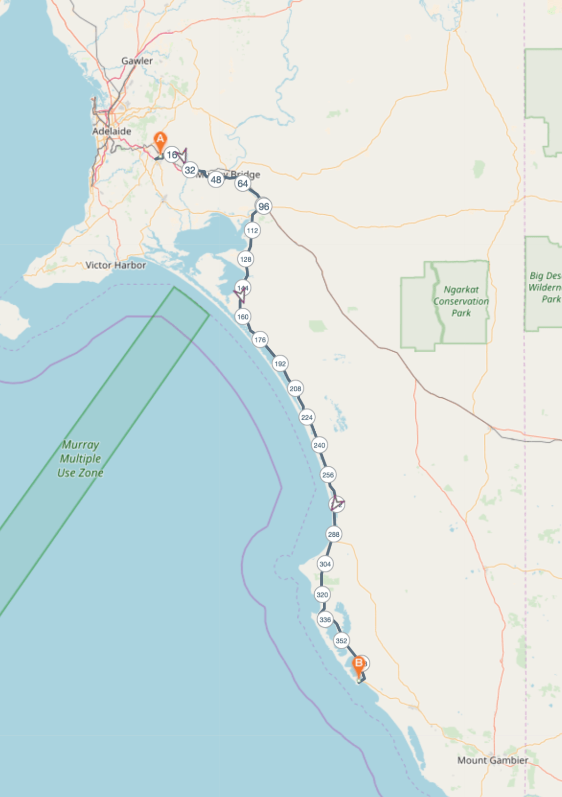
Above:- Our route from Mount Barker to Beachport.  Map courtesy of Plotaroute.

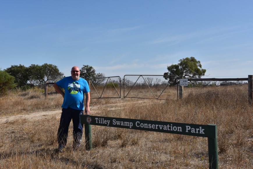
Our first activation on the trip was the Tilley Swamp Conservation Park 5CP-232 & VKFF-0938,  is located about 199 km south east of Adelaide, and about 40 km south of Salt Creek.  The park is located about 5 km inland from the Coorong coast in the Upper South East of South Australia.

Screen Shot 2019-03-28 at 2.03.03 pm.png

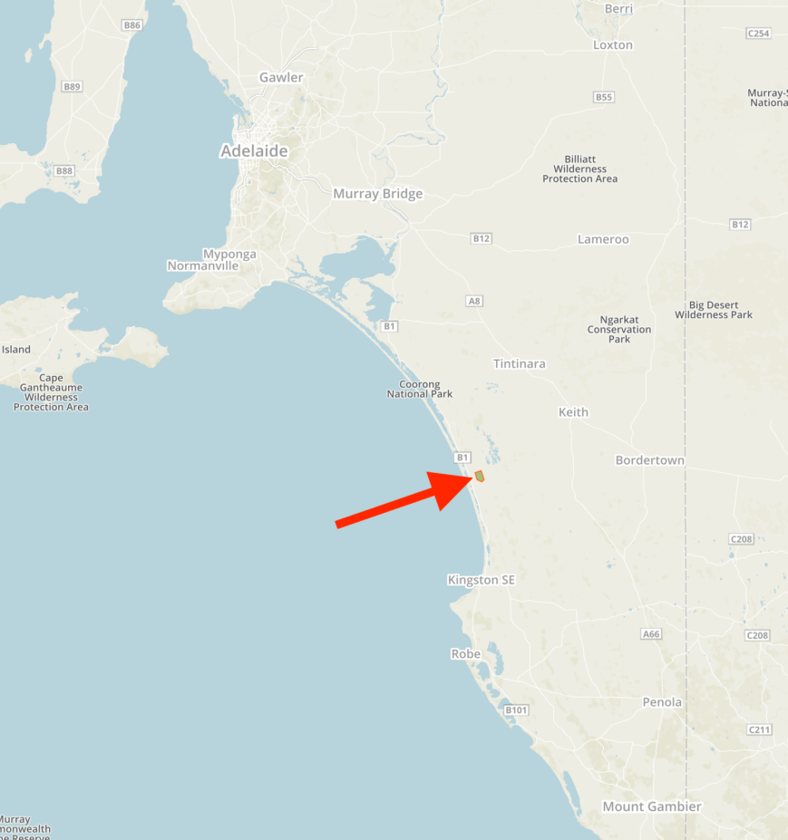
Above:- Map showing the location of the Tilley Swamp Conservation Park in the upper south east of South Australia.  Map courtesy of Protected Planet.

We left home at about 7.45 a.m. and travelled east on the South Eastern Freeway to Tailem Bend, and then turned off onto the Princes Highway.  Our first stop for the day was for a coffee and some breakfast in the town of Meningie, on the banks of Lake Albert.

DSC_6411

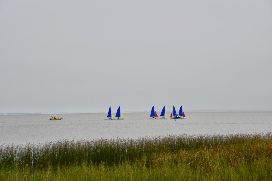
Above:- Sailing on Lake Albert

We got a coffee and a toasted sandwich at the local bakery and then headed down to the foreshore.  There is a monument here for the Birdman of the Coorong, John Francis Peggotty.  He was a local bushranger who often rode on the back of an ostrich, one of the many set free when the market for fashionable ostrich feathers ceased.  There is also a monument re the crash of an Avro Anson aircraft into Lake Albert in 1942.

As Meningie is set on Lake Albert, there are plenty of waterbirds to be found at Meningie.

We then continued out of Meningie on the Princes Highway and soon reached the waters of the Coorong.

DSC_6423

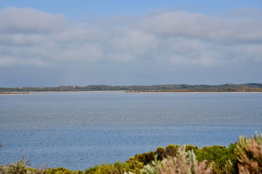
Above:- The Coorong, near Meningie.

The Tilley Swamp Conservation Park is about 1,525 hectares in size and was proclaimed and gazetted in 1993, primarily to ‘conserve remnant vegetation associations’.  It is one of a few reserves in the district containing threatened plant species.  The park also provides habitat for several other threatened species including the Metallic Sun-orchid, Common Wombat, and Rufous Bristlebird.   A large portion of Tilley Swamp Conservation Park contains a seasonally inundated wetland system which forms part of the Tilley Swamp Watercourse.

The park takes its name from the locality, Tilley Swamp, which was named after William Tilley, an early pastoral leaseholder.  On 1st July 1851 Tilley took up pastoral lease no. 199 known as Miserable Creek, calling it Tilley’s Swamp.  Tilley constructed Tilley’s Accomodation House which was one of the stages on the Overland Road to the Victorian gold fields.  The aborigines knew the district as kopanopintar-kopan.  Kopan -‘one’ and pintar -‘stone axe’.

A number of native animals and birds call the park home.  Bird species include the vulnerable Rufous Bristlebird, Yellow Thornbill, Beautiful Firetail, Southern Emu-wren, and Elegant Parrot.  Native animals include the Common Wombat, Red-necked Wallaby, and Western Grey kangaroo.

The park was devastated by a bushfire in February 2013, and during our visit, it was clear that the park was still recovering.

We continued through Policemans Point and Salt Creek, and then turned left into Petherick Road.  We soon reached the conservation park which was well signposted.

I activated this park back in June 2014, but this was prior to Tilley Swamp being included in the World Wide Flora Fauna (WWFF) program.  That activation was for the VK5 National & Conservation Parks Award, only.

https://vk5pas.org/2014/06/11/tilley-swamp-conservation-park/

DSC_6424

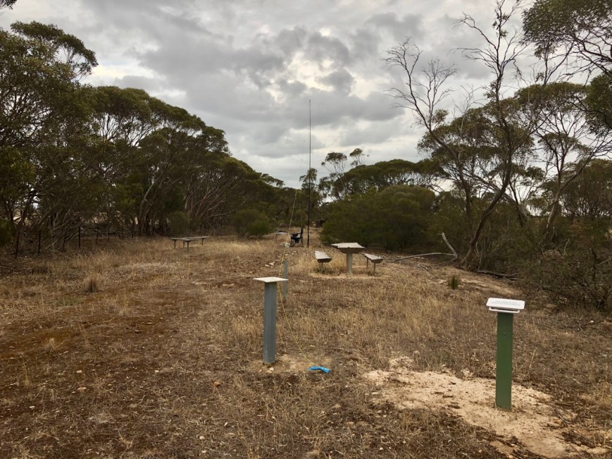
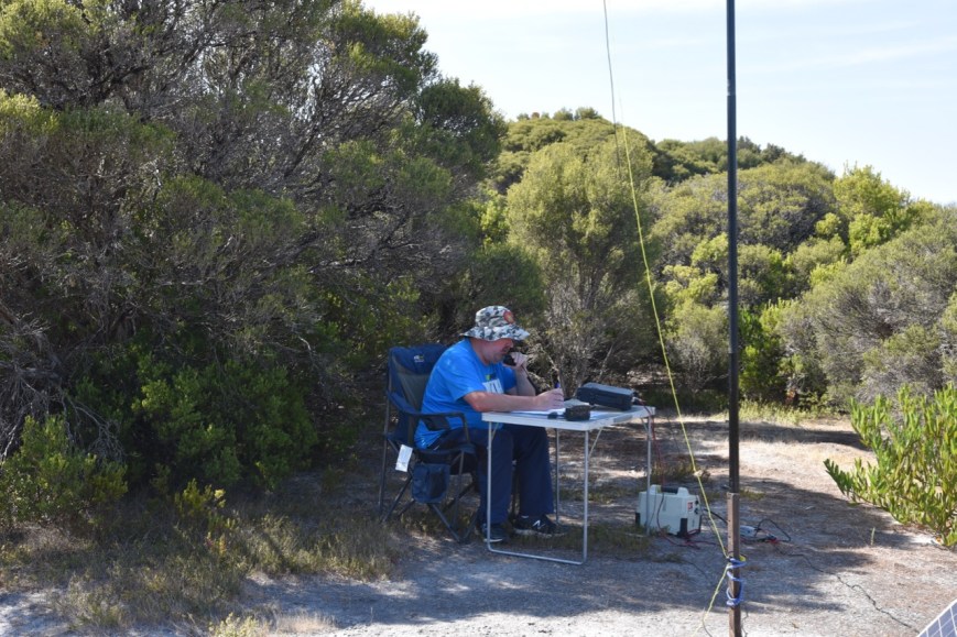
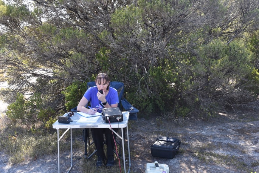
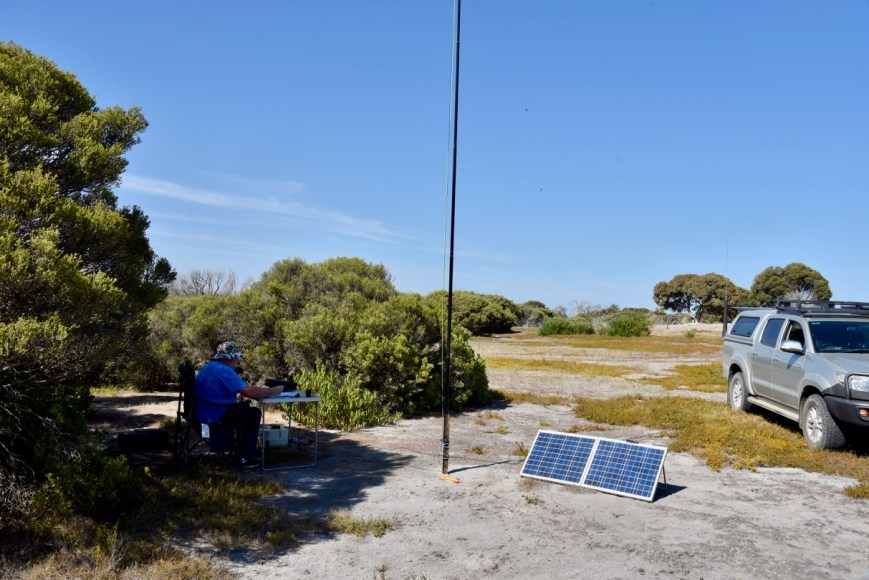
We entered the park through a closed, but unlocked set of gates, and set up just off a 4WD track.  For this activation, we ran the Yaesu FT-897 and the 20/40/80m linked dipole.  Power output was 10 watts PEP for Marija, and 40 watts for me.

Screen Shot 2019-03-28 at 2.02.49 pm.png

Above:- Aerial shot of the park showing our operating spot.  Image courtesy of Protected Planet.

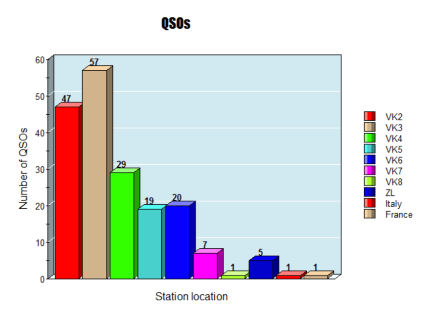
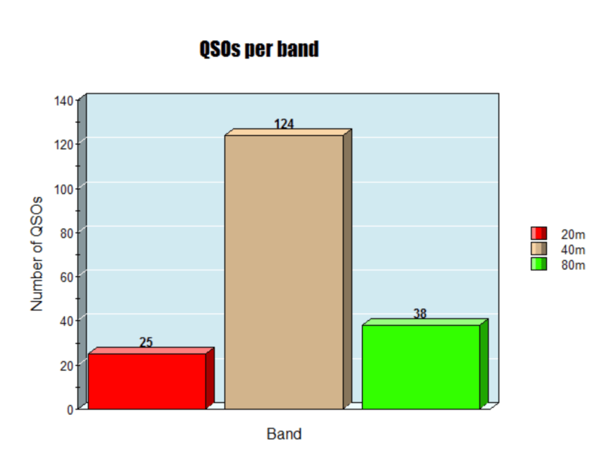
I kicked off the activation, calling CQ on 7.144, while Marija placed a spot for me on both parksnpeaks and on Facebook.  Unfortunately, the static crashes on the 40m band were peaking strength 9, making it quite difficult at time.  First in the log was Ron VK3AHR at Wodonga, followed by Dennis VK2HHA, Peter VK3PF, and then Tony VK3XV mobile in VK5.

It was quite slow going on the band, and it took me 8 minutes to get contact number 10 in the log.  That being a QSO with Ken VK3UH.  I logged a further 2 contacts, before swapping the mic with Marija.

DSC_6428

Marija’s first contact was with Ken VK2KYO, followed by Ron VK3AHR, and then Ken VK3UH.  It took Marija 12 minutes to get 10 contacts in the log, qualifying the park for VKFF.  Once Marija had 11 contacts in the log, we once again swapped the mic.

DSC_6431

Marija and I lowered the squid pole, and inserted the links for the 80m band, and I started calling CQ on 3.610.  Adrian VK5FANA was the first station logged on 80m, followed by Joe VK5WU, and then Ivan VK5HS who was mobile.  Despite the band conditions being quite good, I only logged the 3 stations on 80m.

It was then back to 40m, where I logged a further 13 stations from VK2, VK3, VK4, and VK7.  This included Angela VK7FAMP/p and Tony VK7LTD/p who were both portable in the Wye River State Reserve VKFF-1841.  Marija also logged Angela and Tony.

I then decided to try my luck on the 20m band.  I called CQ on 14.310 and logged 6 stations, all from Queensland.  I now had 34 contacts in the log, and needed just 10 more to qualify the park for the global WWFF program.

I then called CQ for about 5 minutes on 21.244 on 15m, but did not have a single taker.  So I moved back to 40m and called CQ on 7.144.  Unfortunately, there were very few takers, and I logged just 2 more stations, Geoff VK3SQ, and Peter VK3KAI.  Five more minutes of CQ calls failed to yield any callers.

DSC_6429.jpg

I had fallen short by 8 QSOS, of qualifying the park for WWFF.  This is a park I will have to go back to.

Marija worked the following stations on 40m SSB:-

  1. VK2KYO
  2. VK3AHR
  3. VK3UH
  4. VK2QR
  5. VK3PF
  6. VK2JDL
  7. VK4TJ
  8. VK4/AC8WN
  9. VK4/VE6XT
  10. VK2HHA
  11. VK2FAAA/m
  12. VK7FAMP/p (Wye River State Reserve VKFF-1841)
  13. VK7LTD/p (Wye River State Reserve VKFF-1841)

I worked the following stations on 40m SSB:-

  1. VK3AHR
  2. VK2HHA
  3. VK3PF
  4. VK3XV/5
  5. VK2QR
  6. VK2IO
  7. VK4TJ
  8. VK4/AC8WN
  9. VK4/VE6XT
  10. VK3UH
  11. VK2KYO
  12. VK4HNS
  13. VK4CPS
  14. VK7FAMP/p (Wye River State Reserve VKFF-1841)
  15. VK7LTD/p (Wye River State Reserve VKFF-1841)
  16. VK6MB/3
  17. VK2KNV/m
  18. VK4FDJL
  19. VK4NH
  20. VK4DXA
  21. ZL4TY/VK4
  22. VK3ANL
  23. VK2EMA
  24. VK7KT/m
  25. VK2LEE
  26. VK3SQ
  27. VK3KAI

I worked the following stations on 80m SSB:-

  1. VK5FANA
  2. VK5WU
  3. VK5HS/m

I worked the following stations on 20m SSB:-

  1. VK4NH
  2. VK4DXA
  3. ZL4TY/VK4
  4. VK4TJ
  5. VK4/AC8WN
  6. VK4/VE6XT


References.

National Parks & Wildlife, 2000, ‘Tilley Swamp Conservation Park Management Plan’.

Wikipedia, 2019, <https://en.wikipedia.org/wiki/Tilley_Swamp,_South_Australia>, viewed 28th March 2019

2018 VKFF Annual Photographic competition

Each year the VKFF program runs an annual photographic competition.  The competition is sponsored by Jaycar.  The winner receives a $50.00 voucher, kindly donated by Kaycar, and a certificate.  Second and Third place getters, receive a certificate.

1280px-Jaycar-brand.svg

This year, votes were cast via Survey Monkey.

This year I received first place, for my photograph of a Superb Fair Wren, which I took in the Brisbane Ranges National Park.

VK5PAS 2018 VKFF Photo Comp.png

THANKYOU to everyone who voted.

More information can be found on the WWFF Australia website at…….

https://www.wwffaustralia.com/20182.html

VKFF Hunter Honour Roll 1,200

I have been very preoccupied at work this year, working some pretty odd hours and long shifts, so my tally of VKFF parks had slowed down quite a bit.

However, a few days ago I qualified for the next step in the VKFF Hunter Honour Roll.  I have now worked 1,200 different VKFF references.

Thankyou to all of the activators.

VK5PAS VKFF Hunter Honour Roll 1,200.png

Coorong National Park 5NP-005 and VKFF-0115 and the 2019 John Moyle Memorial Field Day

This year, I have had very little time to get out into the fresh air and operate portable.  Sadly, that dreaded place called work has demanded a huge chunk of my time.  But yesterday, with Marija away on a ‘girls weekend’, I packed the 4WD and headed to the Coorong National Park 5NP-005 & VKFF-0115, to take part in the 2019 John Moyle Memorial Field Day.

My intended destination was Parnka Point, which is located about 172 km (by road) southeast of the city of Adelaide, and about 139 km (by road) southeast from my home.

Screen Shot 2019-03-17 at 12.27.35 pm.png

Above:- Map showing the location of the Coorong National Park.  Map courtesy of Protected Planet.

The Coorong National Park is a 130 km stretch of saltwater lagoons protected from the South Ocean by the sweeping sand dunes of Younghusband Peninsula.  The park takes its name from the Ngarrindjeri aboriginal word ‘Kurangk’ meaning ‘long narrow neck’.

This is the home of the iconic novel ‘Storm Boy’, which was made into a movie in 1976.  More recently a 2019  version of the movie was released.

MV5BZmJjNzE0YjQtZmE4ZC00ZGVkLWE4NmQtNzRjMGQwMWZhZDE3XkEyXkFqcGdeQXVyMTY5NDY4NDY@._V1_

The National Park was established in November 1967 as a sanctuary for the many species of birds, animals, and fish that call the park home.  The park has been recognised by BirdLife International as an Important Bird Area.

The video below should give you an idea of the beauty of this area.

The John Moyle Memorial Field Day (JMMFD) is held annually in March in memory of the late John Moyle, VK2JU.   The aim of the JMMFD is…..

“The aim is to encourage and provide familiarisation with portable and field operation, and provide training for emergency situations. The rules are therefore specifically designed and focussed to encourage field operations.”

screen-shot-2018-03-28-at-5-21-31-pm.png

Above:- the late John Moyle, VK2JU.  Courtesy of the WIA

For more detailed information on John Moyle, please see my previous post at…..

https://vk5pas.org/2018/03/28/john-moyle-memorial-field-day-2018/

I set up at Parnka Point, which was a significant meeting site for the five aboriginal tribes that formed the Ngarrindjeri clan.  Parnka is a Ngarrindjeri word meaning ‘sandy beach’.  As you look out across the lagoon, you can see wooden poles in the seater.  These are the remains of a ferry built last century to access the Younghusband Peninsula.

Parnka Point is the narrowest part of The Coorong as the water is less than 100 metres wide.  Parnka Point is where the northern and southern lagoons of The Coorong meet each other.  The water at this point is often referred to as Hells Gate.

It was a beautiful sunny day, with the temperature around 28 deg C.  Other than some campers, and some fishermen, Parnka Point was fairly quiet.  The waters and sky were alive with birdlife, as it always is, during my visits.  I had encountered a 6-foot long Brown snake on the road, on the way into the park.  Fortunately, that was the only snake I saw during the afternoon.

DSC_6401

I ran the Yaesu FT-897 for this activation, with the power output being 40 watts.  My antenna was a 20/40/80m linked dipole, sitting up on the top of a 7-metre telescopic squid pole.  As it was a nice sunny day, I had the solar panels out to top up the battery, a 44 amp hour power pack.  The ‘shack’ was a little shelter shed which overlooked the lagoon.

I was situated on a small peninsula with water either side of me, and the Southern Ocean to my west.

Screen Shot 2019-03-17 at 12.30.21 pm.png

Above:- Aerial shot showing my operating spot.  Image courtesy of google maps

I ran VK Contest Logger on my laptop.  Much easier than paper.

DSC_6407

I was set up and ready to go by just after 2.30 p.m. local time (0400 UTC).  First in the log was John VK1JP/2 on 40m SSB.

I made the following Park to Park contacts during the activation:-

  1. Gerard VK2IO/p – Popran National Park VKFF-0417
  2. Tony VK3XV/5 – Lake Newland Conservation Park VKFF-1046
  3. Peter VK3ZPF/p – Grantville Nature Conservation Reserve VKFF-2101
  4. Alan VK2MG/p – Brisbane Water National Park VKFF-0056
  5. Alan VK5AR – Deep Creek Conservation Park VKFF-0780 (40m)
  6. VK6AHR – Helena National Park VKFF-0645 (40m)
  7. Hans VK6XN – Matilda Bay Reserve VKFF-2825 (20m)
  8. VK6AHR – Helena National Park VKFF-0645 (40m)
  9. Hans VK6XN – Matilda Bay Reserve VKFF-2825 (40m)
  10. Mike VK6MB/3 – Gippsland Lakes Coastal Park VKFF-0747
  11. Nick VK6NDX/p – Morangerel Nature Reserve VKFF-2832
  12. Alan VK5AR/p – Deep Creek Conservation Park VKFF-0780  (80m)

Some of the highlights of the activation were:-

  • Perrin VK3XPT using a military manpack.
  • VK3FOXR – QRP running just 2.5 watts
  • Ken ZL1KEN – maritime mobile
  • Joseph F6CTT on 40m
  • Jemma VK3SCM – a young scout who sounded like she had been an op for 10 years
  • Gary ZL4U with a massive signal on 40m
53026439_10155810651147234_7335308764335046656_o

Above:- Perrin VK3XPT’s military radio.  Image courtesy of VK3XPT

My 6 hour period concluded at around 8.30 p.m. (1000 UTC).  The sun had just set.  My final contact was with VK3ER on 80m.

In my 6 hour block I ended up making a total of 187 QSOs on 20, 40 & 80m SSB, with a claimed score of 374 points.  This was down a bit on previous years.  This year I found long periods of calling CQ field day, with no takers.  As this is a ‘contest’ self-spotting is not allowed.  So the usual spots on parksnpeaks did not occur.  There is absolutely no doubt that parksnpeaks increases the number of QSOs in our log.

One of the big problems this year was the static crashes.  They were strength 9 plus at times, and made it extremely difficult picking out the weaker stations that were calling me.  I’m sorry to those who called, who I wasn’t able to pull through.  And I’m sure there were many stations on the east coast who were simply unable to hear my signal.

The graph below shows my activity during the Field Day.

Capture

The map below shows my QSOs during the Field Day.  I worked one French station on 40m SSB, and one Italian station on 20m SSB.  Sadly, I didn’t really find a DX opening on 20m, but that may have been as a result of my timing in using that band.

Screen Shot 2019-03-17 at 12.00.49 pm.png

The map below shows my contacts around Australia, and into New Zealand.

Screen Shot 2019-03-17 at 12.01.03 pm.png

The graph below shows my QSOs during the Field Day.  The majority of contacts, a total of 57, came from Victoria (VK3), followed by New South Wales (VK2) with 47.

Screen Shot 2019-03-17 at 12.17.48 pm

The majority of my contacts were made on the 40m band (124 QSOs), followed by 80m (38 QSOs), and then 20m (25 QSOs).

Screen Shot 2019-03-17 at 12.08.38 pm

THANKYOU to everyone who called, and I wish everyone who took part in the Field Day, good luck.


References.

Parks SA, 2019, <https://www.parks.sa.gov.au/find-a-park/Browse_by_region/Limestone_Coast/coorong-national-park>, viewed 17th March 2019

Wikipedia, 2019, <https://en.wikipedia.org/wiki/Coorong_National_Park>, viewed 17th March 2019

WWCR QSL card

In the last few days I received an envelope from radio station WWCR in Nashville, Tennessee, USA.

I had tuned in to WWCR on 20th January 2019.

WWCR.jpg

The QSL card included a friendly message from the Program Director.  Also included in the envelope was a WWCR sticker and a broadcast schedule.

WWCR0001.jpg


Presentation at the North East Radio Club

Last night (Friday 8th February 2019), Marija VK5FMAZ and I attended at the clubrooms of the North East Radio Club, and delivered a presentation entitled ‘Having fun in the field’.

We spoke about the WWFF program, the VK5 Parks Award, equipment used, and some operating tips for both activators and hunters.

We also had an amount of gear on display, including awards, transceivers, antennas, portable power supplies, and other sundry equipment.

Many thanks to Tony VK5FBIC who organised our attendance, and many thanks to the members of NERC who attended.

The photos below are courtesy of Stuart VK5STU.

Nurragi Conservation Reserve VKFF-2247

On Saturday 26th January 2019, we celebrated Australia Day, the official National Day of Australia.  It marks the anniversary of the 1788 arrival of the First Fleet of British ships at Port Jackson in New South Wales.  It is also one of only three days of the year when Australian amateur radio operators can replace the regular VK prefix with AX.

AX5PAS (Australia Day).jpg

I arrived home from a day at work at about 5.30 p.m. local time, and with the help of Marija, packed the car and headed south to the Nurragi Conservation Reserve VKFF-2247.  The park is located about 67 km south east of the city of Adelaide. 

screen-shot-2017-08-11-at-12-39-04-pm

Above: Map showing the location of the Nurragi Conservation Park, south east of Adelaide.  Map courtesy of Location SA Map Viewer.

I have activated Nurragi twice before, back in August and September 2017, and have well and truly qualified the park for the World Wide Flora Fauna (WWFF) program.  For info on those previous activations, and some interesting history on the park, please see my previous posts……. 

Nurragi Conservation Reserve VKFF-2247

Nurragi Conservation Reserve VKFF-2247

Nurragi is an aboriginal word for scrub.  Nurragi is a heritage listed reserve which was dedicated in 1991 by the Minister of Lands dedicated the area as a Nature Conservation and Plantation Reserve under the Crown Lands Act 1929.  A Heritage Agreement has since been established under the Native Vegetation Act 1991.  

Screen Shot 2019-01-28 at 6.56.16 pm.png

Above:- The Nurragi Conservation Reserve.  Image c/o Friends of Nurragi Association

The park is under the control of the Friends of Nurragi Association, which was established in 1988, and includes representatives of the local Alexandrina Council, Strathalbyn Naturalists, the National Trust of South Australia, and other members of the community.

There are no facilities in the park, however there are a number of information boards, courtesy of the Friends of Nurragi.

img_1685

The Nurragi Conservation Reserve has been established to protect the remnant vegetation along the former rail line, and to re-establish flora indigenous to the original Milang Scrub which originally extended from Belvidere in the north to Point Sturt in the south and Finniss to the west.  Today, less than 2% of that vegetation now exists.  The reserve is completely surrounded by land which has been cleared for farming.

img_1687

The reserve is 65 hectares in size, and is the remains of a 14 km railway line which operated between Sandegrove and Milang from around 1884 until 1970.  The line linked the river port of Milang to the railway network to the city of Adelaide via Sandegrove and Strathalbyn.  The only siding on this section of the railway line was at Nurragi.  For several years, the reserve terminated at Landseer Road on the outskirts of Milang but in 2001 a further section was dedicated, completing the link through to Milang and Lake Alexandrina.

Screen Shot 2019-01-28 at 7.11.03 pm.png

Above:- Last day of passenger service to Milang 30/11/68.  Image courtesy of Friends of Nurragi

More than 300 species of Australian native plants can be found in the reserve.  Of those, 67 are of particular conservation significance.  

Various native mammals call the reserve home including Western Grey kangaroos and Brush-Tailed possums.  Birds SA have recorded about 97 species of birds in the reserve including Peaceful Dove, Weebill, Australian Magpie, Little Raven, Grey Shrikethrush, Diamond Firetail, Southern Boobook, Red-capped Robin, Hooded Robin, and Rufous Whistler.

After leaving the town of Strathalbyn, I travelled south on Dry Plains Road, and then turned left onto Nurragi Road.  I set up on the northern side of Nurragi Road.  I ran the Yaesu FT-897, 40 watts, and the 20/40/80m linked dipole for this activation.

I was set up and ready to go by about 6.10 p.m. local time.  Sadly when I turned on the transceiver, I found that the 40m band was very noisy, with static crashes reaching strength 9.  It was the product of a lot of storm activity around Australia.  The temperature in the park was a very pleasant 23 degrees C.  This was off the back of a very hot 46 deg C day the previous day.

img_1686

Above:- My operating spot in the park.

First in the log was my good wife, Marija VK5FMAZ, who had seen my self spot on parksnpeaks.  This was followed by Daniel AX4FOMP, who had recently sent me an email expressing his interest in getting involved in the WWFF program.  Next was Nick VK3ANL/AX3ANL, and then Andrew VK2PEZ/VK2ZEP.

Unfortunately the static crashes were loud and I’m sure this affected the number of callers.  The band conditions appeared to be quite good, with good strong signals, from particularly Queensland and Tasmania.  But those static crashes were loud.

I logged a total of 21 stations on 40m, before lowering the squid pole and inserting the 80m legs.  I called CQ on 3.610 and this was answered by Peter VK3ZPF/p who was activating the Sassafras Creek Nature Conservation Reserve VKFF-2187.  It is always nice to get a Park to Park contact in the log.  This was followed by Les VK5KLV.  It was a bit of a struggle to log Les, as his signal was quite low down amongst the static crashes, but we made it.  I logged a further 5 stations on 80m, before heading off to the 20m band.

I called CQ on 14.310 for a few minutes, with no takers, and then all of a sudden Rob VK4SYD came up with a strong 5/8 signal.  We exchanged signal reports and pleasantries just in time, as not long after we had finished our contact, up came the Over the Horizon Radar, which was over strength 9.  It virtually wiped out the 20m band.

I moved back to 40m, which had become quite busy now, with signals starting to come in from North America.  I called CQ on 7.148 and this was answered by Chuck VK2SS/p, followed by Lee AX2LEE, and then Andrew VK2AC.  I logged a further 8 stations on 40m, before a WB2 station came up on frequency and started calling CQ.  Unfortunately he was unable to hear me.

So to complete the activation I headed back down to the 80m band, where I logged 3 stations, Rob VK4SYD (3rd band worked), Scott VK4CZ, and Andrei ZL1TM in New Zealand.  

After 2 hours in the reserve, it was time to pack up and head home for some late dinner.  I had exactly 44 QSOs in the log.

I worked the following stations on 40m SSB:-

  1. VK5FMAZ
  2. AX4FOMP
  3. VK3ANL
  4. AX3ANL
  5. VK2PEZ
  6. VK2ZEP
  7. VK4CZ
  8. VK3PF
  9. VK7JON
  10. VK4SYD
  11. VK4SMA
  12. AX4SMA
  13. VK4PDX
  14. VK2PKT
  15. VK4TJ
  16. VK1HW
  17. AX4MU
  18. VK4MU
  19. VK2TUO
  20. AX4HNS
  21. VK2HMV
  22. VK2XXM
  23. AX2SS/p
  24. AX2LEE
  25. VK2AC
  26. AX4FARR
  27. VK2WQ
  28. VK4MWB
  29. VK4DI
  30. VK7PSJ
  31. VK2AD
  32. VK2RR
  33. VK7GH

I worked the following stations on 80m SSB:-

  1. AX3ZPF/p (Sassafras Creek Nature Conservation Reserve VKFF-2187)
  2. VK5KLV
  3. VK3PF
  4. VK3ARH
  5. VK5FMAZ
  6. AX5FANA
  7. VK5PL
  8. VK4SYD
  9. VK4CZ
  10. ZL1TM

I worked the following station on 20m SSB:-

  1. VK4SYD


References.

Birds SA, 2019, <https://birdssa.asn.au/location/nurragi-conservation-reserve/>, viewed 28th January 2019

National Trust, 2019, <https://www.nationaltrust.org.au/places/nurragi-conservation-reserve/>, viewed 28th January 2019

Walking SA, 2019, <https://www.walkingsa.org.au/walk/find-a-place-to-walk/nurragi-conservation-reserve-walking-trail/>, viewed 28th January 2019

Wikipedia, 2019, <https://en.wikipedia.org/wiki/Australia_Day>, viewed 28th January 2019