
On Saturday evening (6th May 2017) I headed to the Ferries McDonald Conservation Park 5CP-067 & VKFF-0881 to take part in the Harry Angel Memorial 80m Sprint. Ferries McDonald is located about 38 km by road, south east of my home, and around 72 km south east of the city of Adelaide.
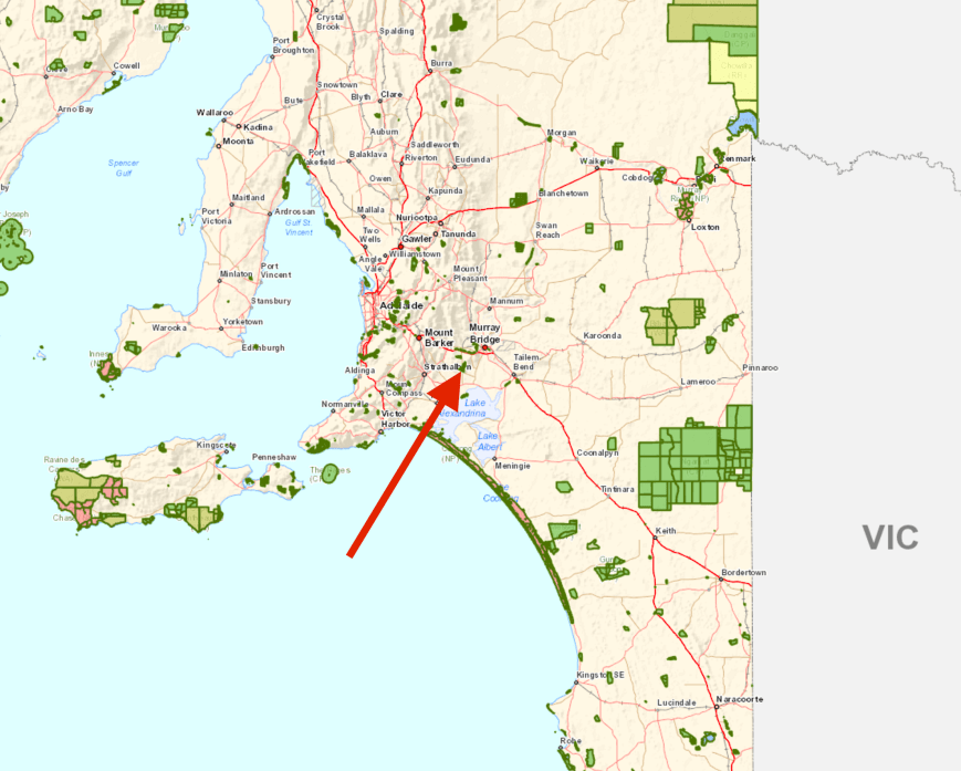
Map showing the location of the Ferries McDonald Conservation Park. Map courtesy of Location SA Viewer.
I have activated Ferries McDonald a number of times previously. In fact a total of 5 times. More information on those previous activations can be found on my previous posts at….
https://vk5pas.org/2016/04/27/ax5pas-at-monarto-conservation-park-5cp-067-and-vkff-0881/
https://vk5pas.org/2015/08/03/ferries-mcdonald-conservation-park-vkff-881/
https://vk5pas.org/2015/01/08/ferries-mcdonald-conservation-park-3/
https://vk5pas.org/2014/05/18/ferries-mcdonald-conservation-park-2/
https://vk5pas.org/2013/05/26/ferries-mcdonald-conservation-park/

Aerial shot of the park, looking east. The Murray River is visible in the background, and Lake Alexandrina is to the right of the picture. Courtesy of google maps.
Ferries McDonald Conservation Park covers an area of about 880 hectares and contains one of the few pieces of remnant Mallee vegetation close to Adelaide. It is important as it has never been cleared for farming, and is an example of the original vegetation of the area. The dense mallee habitat provides a refuge for over 300 species of plants, including a number of rare and endangered species.
More than 90 species of birds have been recorded in the park including Superb Blue Wrens, Gold Whistlers, Rufous Whistlers, Yellow-rumped Thornbills, Mallee Ringneck Parrots, and White-browned Babblers. Ferries McDonald is also home to the elusive and nationally endangered Malleefowl. I have never seen Malleefowl in this park, and have only ever witnessed this rarely seen bird on one occasion during all of my park activations. That was in Mount Boothby Conservation Park, further to the south east of Ferries McDonald.
Numerous native animals can be found in the park including echidnas, marsupial mouse, and Western Grey kangaroos.

Aerial shot of the park looking west. My QTH is indicated with the blue marker. Courtesy of google maps.
The park was once part of a vast area of mallee bushland which was cleared for farming during the late 1800’s. Fortunately a few rocky outcrops were unsuitable for farming, and were preserved in their original state. In January 1938, an area of 1,600 acres was gazetted under the Animals and Birds Protection Act, as a closed area for birds and animals, thus creating the first reserve in South Australian specifically for mallee fauna. A total of 233 acres were made available by Robert Sweet McDonald of ‘Preamimma’, Monarto, 583 acres made available by Mr. G Lemmey of Two Well, whilst a further 779 acres allocated by the State. It was initially known as Chaunceys Line Scrub.
An addition to the park was made in 1953 from a bequest from James Ferries, thus creating the Ferries-McDonald Conservation Park.
To get to the park I drove south out of Mount Barker, along Wellington Road until I reached the little town of Woodchester. I then drove north east along the Callington Road until I reached Chaunceys Line Road where I turned right and drove into the now ‘ghost town’ of Hartley which is located a few km away from the park.
Hartley is located close to the Bremer River, which was originally known as the Hindmarsh River, and later named after distinguished British Royal Navy officer James Bremer. It is located between the fertile foothills of the eastern Mount Lofty Ranges and the dry mallee plains before the Murray River. The Hartley district was first referred to as ‘The Bremer’ and was settled in the early 1850’s by Methodist and Lutheran pioneers. One of those pioneers was William Jacob Cross who named the area ‘Hartley’ after his farm in Devonshire in the United Kingdom.
Little remains of what once a bustling community. The Hartley Methodist Church lays in ruins at the junction of Callington Road and Chaunceys Line Road, referred to by locals as ‘Chapel Corner’. The church which was built in 1865, sat on an acre of land which was originally purchased by 13 trustees of the Mount Barker Methodist congregation in 1857 for the sum of 5 pound.
A little further along the road is the old Hartley Creamery which was opened in 1894 as a branch of the Mount Barker Butter Factory. It is now a private residence. Continue along Chaunceys Line Road and you will reach the Corner Tree-The Duke’s Tree. This large gum tree commemorates the visit of His Royal Highness Prince Alfred Ernest Albert, Duke of Edinburgh on 5th November 1867, who was travelling from Wellington to Mount Barker. The Hartley community welcomed the Duke and his entourage with a luncheon under the Blue Gum tree.


Chauncey’s Line Road was originally surveyed to link Adelaide with the eastern States. The route and line was surveyed in 1851 by Mr. William Chauncey who was engaged to survey the ‘Great Eastern Road’ between Hahndorf and Wellington. The plan was abandoned when it was found that there was no suitable foundation for a bridge at Wellington. Instead the bridge was built at Murray Bridge further upstream.
It was a slow drive approaching the park, as it was dusk and there were a lot of kangaroos out on the road.

Chaunceys Line Road
What about the Harry Angel Sprint?
The Harry Angel Sprint is an annual 80m contest which was first established in 1999 to commemorate the life of Harry Angel VK4HA, who, at the time of his death in 1998 at the age of 106, was the oldest licenced amateur in Australia.
Who was Harry Angel?
Henry Benjamin ‘Harry’ Angel was born on 14th December 1891 at Manor House, Essex, England. His parents were Henry Samuel Martin Angel (1867-1911) and Elizabeth Jesse Angel nee Eyre (1871-1962). In 1919 he married Rebecca Andrews (1891-1973). They had 3 children: Lillian May Angel, Harold Vincent Angel, and Ronald Henry Angel. Harry died in August 1998 at Brisbane, Queensland, aged 106 years.

Harry Angel. Image courtesy of ancestry.com.au
The State Library of Queensland holds an extensive collection of QSL cards, previously belonging to Harry Angel.

A selection of JA cards in the Harry Angel QSL card collection. Image courtesy of State Library of QLD
I soon reached the park. It was now almost completely dark.

I operated from my normal operating spot at Ferries McDonald, which is the main car park area in the south eastern corner of the park.
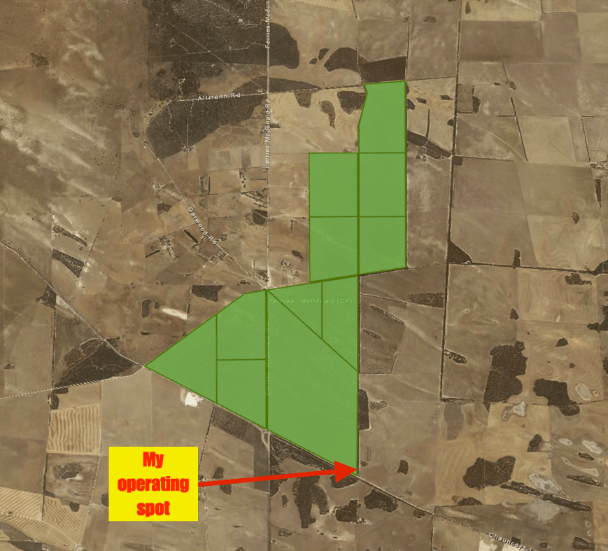
Aerial shot of the park showing my operating spot. Image courtesy of Location SA Viewer.
I was running a little late of my posted activation time of 0830 UTC, as I had stopped off at Hartley to get some photographs. So I was set up and ready to go, 20 minutes late, just before 0850 UTC (6.20 p.m. South Australian local time). I ran my normal portable station for this activation: Yaesu FT857d, 40 watts, 20/40/80m linked dipole-inverted vee supported on the 7m squid pole.
It was not a cold evening, not for me anyway, with the temperature being about 13 deg C, so I sat outside the vehicle on my deckchair with the gear on the fold up table. I initially used a paper log, but later converted to VK Logger on the laptop for the Harry Angel Sprint.
My first contact was with my wife Marija VK5FMAZ. I had dropped her a quick SMS message to let her know that I was set up and ready to go. This was followed by Ray ZL4HSV on the North Island of New Zealand, Colin VK4PDX, and then Mick VK6AY. Band conditions were quite poor, and I only logged 14 stations on 40m from VK2, VK4, VK5, VK6, and New Zealand. There was lots of fading present on most signals from VK2 and VK4, and I also had to contend with some JA QRM on the frequency. At around 0930 UTC some Indonesian and Malaysian stations came up on the frequency and totally took it over. Their signals were S9 and it was just not viable to continue on 7.130.

")

I had about 25 minutes before the start of the Sprint, so I had a quick tune across the band but could not hear a lot of strong stations. Even the normal USA stations were significantly lower in signal strength compared to normal. So I set up the laptop and had one final read of the rules for the Sprint and had a tune across the 80m band.
The 80m band was very quiet leading up to the Sprint and then at 1000 UTC it came alive. I was about to ask if the frequency was in use, when a VK2 started calling CQ Contest, so I moved up the band until I found a clear spot, and started calling CQ. First in the log was Gerard VK6QM, followed by Tony VK3AN, and then Errol VK2EGC/4.
I worked a total of 63 stations during the Sprint from VK2, VK3, VK4, VK5, VK6, VK7, and VK8. No VK1’s were logged. There were long periods of calling CQ with no takers. However, considering I was operating portable I was happy with the results.

I remained on 80m for around 30 minutes after the Sprint and logged a further 14 stations including a number of regular park hunters. I then decided to try one last time on 40m and called CQ on 7.155. This was answered by Ted VK6NTE, followed by Les VK2CPC, and then Mark AF6TC in California, and Lawrence KN7D in Utah.
It was now 11 deg C, 10.15 p.m. local time, and time for me to pack and up and head home for some late dinner. I had a total of 95 contacts in the log.
I worked the following stations on 40m before the contest:-
- VK5FMAZ
- ZL4HSV
- VK4PDX
- VK6AY
- VK4FW
- VK2YES/p
- VK4TJ
- VK4DA
- VK2FOUZ
- ZL1TM
- VK6FSEA
- VK2WDD
- VK4FMAX
- VK6ATM
- VK6NTE
- VK2CPC
- AF6TC
- KN7D
I worked the following stations on 80m after the contest:-
- VK5FANA
- VK4EKA
- VK2NP
- VK5SFA
- VK2NZ
- VK3UCD
- VK4HHA
- VK3ANL
- VK4FE
- VK3FSLG
- VK3FPSR
- VK2SR
- VK5GR
- VK3SFG
I worked the following stations on 80m during the contest:-
- VK6QM
- VK3AN
- VK2EGC/4
- VK3BSE
- VK4LAT
- VK5CP
- VK4PDX
- VK3PH
- VK3QD
- VK2VU
- VK2TTL
- VK3ZVX
- VK2CDS
- VK3JL
- VK2YW
- VK3LDB
- VK7JGD
- VK5FMAZ
- VK5KX
- VK3FVKI
- VK5KBJ
- VK5TE
- VK4FMAX
- VK5DT
- VK2AC
- VK5MU
- VK6NC
- VK2DEK
- VK5LJ
- VK2MT
- VK3PAT
- VK5FFAU
- VK8GM
- VK3XL
- VK2FOUZ
- VK2QN
- VK2NED/p
- VK5ST
- VK2MTM
- VK2AU
- VK6AY
- VK3FSPG
- VK3MPR
- VK3FCEV
- VK2VK
- VK2XIC
- VK2KQB
- VK3IO
- VK5WOW
- VK2HJ
- VK4ADC
- VK6AHR
- VK3GB
- VK4KET
- VK2YX
- VK4WJW
- VK4NA
- VK2TTP
- VK4SN
- VK2SR
- VK4YZ
- VK5FANA
- VK5BC
References.
Ancestry.com.au, 2017, <https://www.ancestry.com.au>, viewed 7th May 2017
National Parks South Australia, 2017, <http://www.environment.sa.gov.au/parks/Find_a_Park/Browse_by_region/Fleurieu_Peninsula/ferries-mcdonald-conservation-park>, viewed 7th May 2017
Redcliffe & Districts Radio Club, 2017, <http://www.redclifferadioclub.org.au/oldsite/harry_angel_38.html>, viewed 8th May 2017
Wikipedia, 2017, <https://en.wikipedia.org/wiki/Bremer_River_(South_Australia)>, viewed 7th May 2017

Hi Paul,
I am sorry I missed you. We were watching something on TV just prior to the news. I had been listening on 40m but had doubts about whether I would hear you and was hoping there would be a post that you had moved to 80m. Anyway, that is in the past. I really enjoyed the post and reading about Harry Angel. And you qso total is very impressive.
Cheers
John D
VK5BJE/VK5PF
Hi John,
I’d like to go for a really good walk through this park one day and see how many Malleefowl mounds/nests I can find. It’s in dispute as to how many Malleefowl exist in the area. As you know they are really hard to spot. I saw a handful of them a few years ago at Mount Boothby.
Cheers,
Paul VK5PAS.
Hi Paul, we could make it a foursome! But not this week!
Cheers
John D
Brilliant activation and great statistics.
Chris
VK4FR/VK5FR
Hi Paul, thanks for a great post. Dianne and I have mostly settled in at our new QTH at Goolwa North, so I have been scouting the area and drove up to Ferries McDonald CP yesterday for a squizz. It’s only half an hour away via Langhorne Creek so it is very handy for me. It looks like this CP is very nice location to do a park activation. I’ll set about preparing some gear across the school holidays and visit the park this spring after the kids have buggered off, and before it gets too hot. If its quiet, I might also get to do some photographic ‘twitching’.