Heathcote Graytown National Park VKFF-0624 and Mount Ida VK3/ VU-009

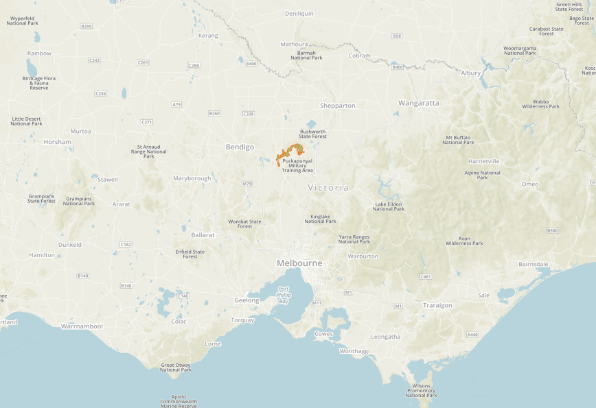
After leaving Axedale, Marija and I continued east along the McIvor Highway, passing through the little town of Knowsley and the north eastern corner of Lake Eppalock.  Our planned destination was the Heathcote Graytown National Park VKFF-0624.  We hoped to activate a SOTA summit within the park, Mount Ida VK3/ VU-009.

This was to be another unique park for both Marija and I for both WWFF and the KRMNPA.

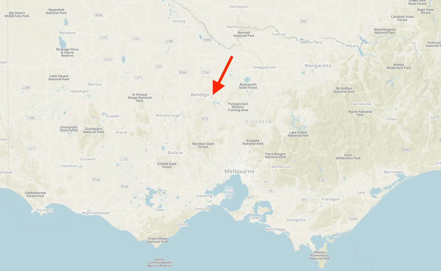
The park is located about 7km north of the town of Heathcote, and about 133 km north of Melbourne.

Screen Shot 2018-12-07 at 11.02.22 am

Above:- Map showing the location of the Heathcote-Graytown National Park.  Map courtesy of Protected Planet

As we travelled along the Northern Highway the park came into view.

We soon reached the park boundary on Mount Ida Road.  The park was well signposted.

The Heathcote Graytown National Park is 12,833-hectare (31,710-acre) in size and was established on the 30th October 2002.  It was primarily established to protect Victoria’s diminishing Box-ironbark forests.  The park includes sections of the Great Dividing Range, Australia’s most substantial mountain range and the third longest land based range in the world.

The park lies within the Rushworth Box-Ironbark Region Important Bird Area, identified as such by BirdLife International due to its importance for swift parrots and other woodland birds.

Swift_Parrot

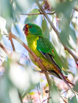
Above:- Swift Parrot (courtesy of Wikipedia)

Mount Ida is 450 metres above sea level and is worth 1 point in the Summits on the Air (SOTA) program.  It has been activated a total of 24 times, with the first activation by Peter VK3PF in May 2012.

Screen Shot 2018-12-07 at 1.07.36 pm.png

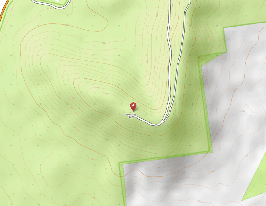
Above:- Mount Ida summit.  Map courtesy of Open Topo Map

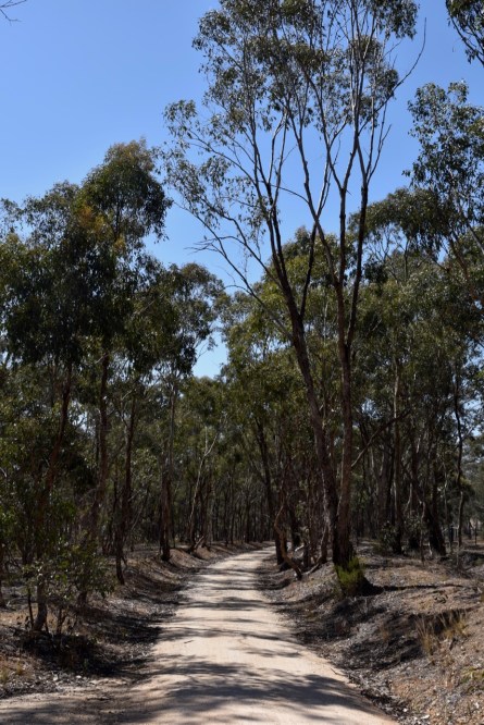
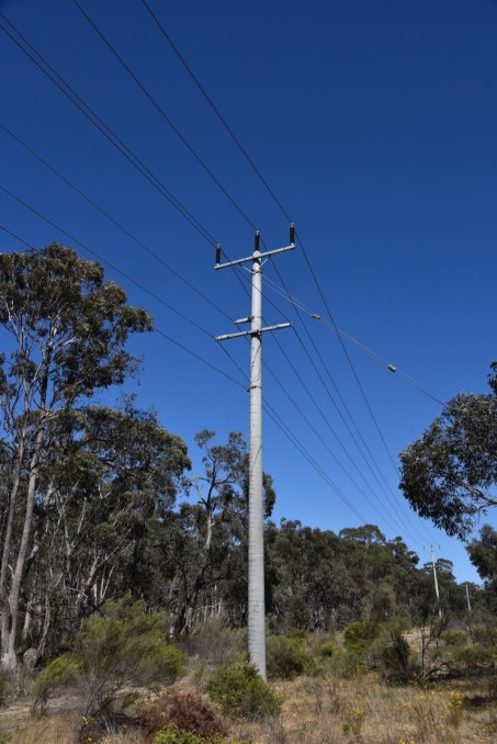
The Mount Ida Road, off the Northern Highway leads to the top of the summit.  The track is dirt, but is in good condition and easily passable in a conventional vehicle.  There is communications equipment, a fire spotting tower, and a trig point at the summit.

And once you are there you are rewarded with some terrific views of the surrounding countryside.

This slideshow requires JavaScript.

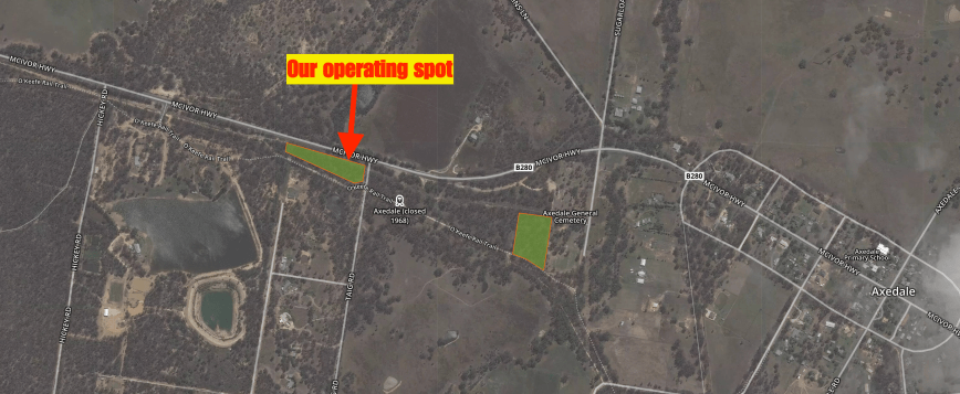
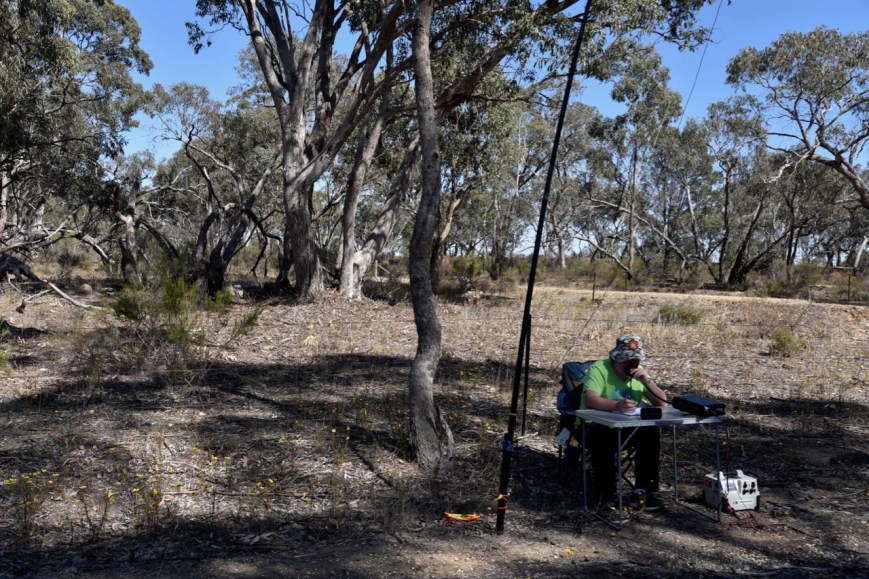
There is a carparking area on Mount Ida Road and a locked gate.  From there it is a 300 metre uphill walk to the summit.  We were fortunate in that during out visit, the gate was open as there was a gentleman in the fire spotting tower, who kindly allowed us to drive to the top of the summit.  We parked the car near the fire spotting tower, and walked back down the track a short distance and set up on the side of the track.

Screen Shot 2018-12-07 at 11.02.13 am.png

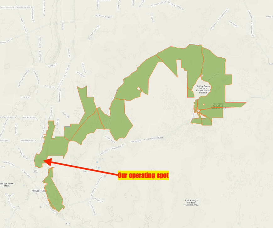
Above:- Map of the Heathcote-Graytown National Park, showing our operating spot.  Map courtesy of Protected Planet

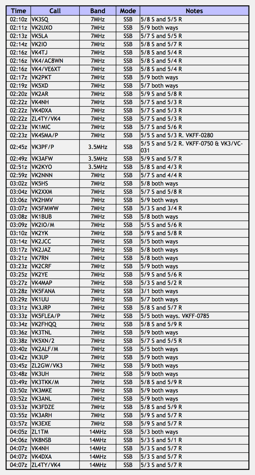
First in the log for this activation was Geoff VK3SQ, followed by Peter VK2UXO, and then Andy VK5LA.  Contact number 4, qualifying the summit for me, was Gerard VK2IO with a good strong 5/8 signal from Sydney.

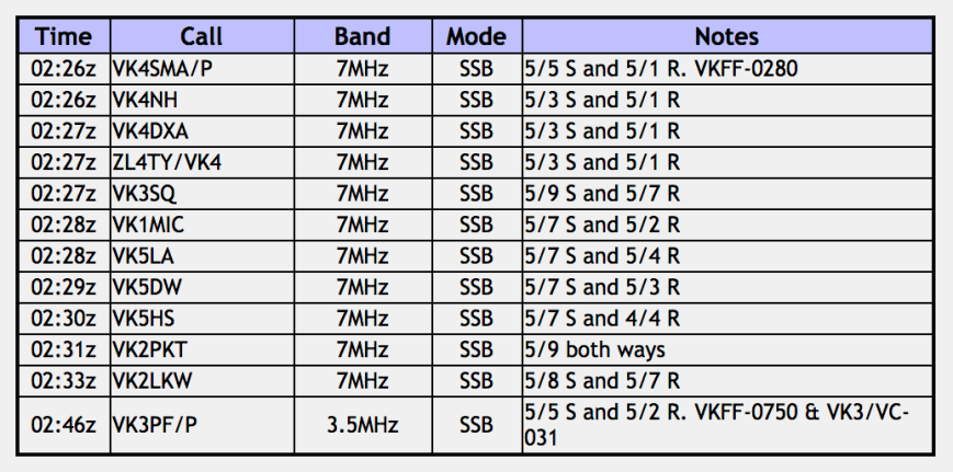
I worked a total of 15 stations on 40m from VK1, VK2, VK3, VK4 and VK5.  This included a Park to Park contact with Mark VK4SMA/p who was activating the Lamington National Park VKFF-0280.

I then swapped the mic with Marija whose first contact was with Mark VK4SMA/p in VKFF-0280.  This was followed by Ray VK4NH, who with his 2 other callsigns, qualified the SOTA summit for Marija.  Marija kept boxing on, logging contacts on 40m, whilst I went for a walk on the summit.  If you follow the track to the north western side of the summit, you will reach the lookout.

I returned about 15 minutes later, and by that time Marija had 11 contacts in the log.

We then swapped the mic again and decided to have a listen on the 80m band.  First in the log there was a Summit to Summit/Park to Park contact with Peter VK3PF/p who was activating Arthurs Seat VK3/ VC-031 in the Arthurs Seat State Park VKFF-0750.  Ron VK3AFW followed, and then my 3rd and final contact on 80m, Ken VK2KYO.

I was keen to try to get my 44 contacts, so I moved back to 40m where I logged a further 31 contacts.  Contact number 44 was a QSO with Peter VK3TKK/m in his mobile.   Another Park to Park was also logged, John VK5FLEA/p who was in the Mylor Conservation Park VKFF-0785.

To complete the activation I called CQ on 14.310 in the 20m band.  VK2PRC gave me a shout, but unfortunately it appeared he could not hear me well, and I was unable to log the contact.  Andrei ZL1TM in New Zealand then called in, followed by Stuie VK8NSB in Darwin, and then Ray VK4NH.

DSC_3868.jpg

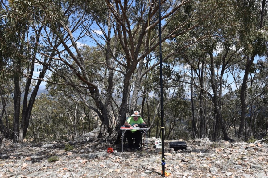
Above:- ‘the shack’ at Mount Ida.

Marija worked the following stations:-

Screen Shot 2018-12-07 at 2.05.43 pm

I worked the following stations:-

Screen Shot 2018-12-07 at 1.59.29 pm.png

At the conclusion of the activation we drove in to the town of Heathcote for a very quick look.  Gold was discovered in the area in late 1852.  Within 6 months there were about 40,000 miners camped in the vicinity of McIvor Creek.  Gold was so easily found in the area, that by the end of 1852 a large number of the miners had left as the gold supply had been exhausted.  It did however prove to be one of the richest finds during the Australian gold rushes.

DSC_3902

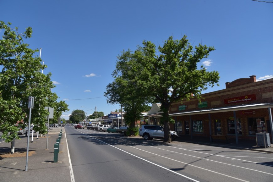
There are a number of historic buildings in the town from the gold rush era, many of which have interpretive signs.  Marija and I both agreed that this is one little town we will need to revisit and explore.


References.

Wikipedia, 2018, <https://en.wikipedia.org/wiki/Heathcote-Graytown_National_Park>, viewed 7th December 2018

Wikipedia, 2018, <https://en.wikipedia.org/wiki/Great_Dividing_Range>, viewed 7th December 2018

Wikipedia, 2018, <https://en.wikipedia.org/wiki/Heathcote,_Victoria>, viewed 7th December 2018

Day three, and the Axedale Flora and Fauna Reserve VKFF-2037

Day three was now here, Sunday 18th November 2018.  It was time to leave Bendigo and head to Shepparton where we had planned to stay 2 nights.  It was a relatively short 120 km drive up the Midland Highway to Shepparton, but we decided to take the ‘scenic’ route, with our intention to activate the Heathcote-Graytown National Park.  This would be a unique park for both Marija and I for both the World Wide Flora Fauna (WWFF) program, and the Keith Roget Memorial National Parks Award (KRMNPA).  I am aiming for my KRMNPA Grand Slam, awarded for having activated and worked all 45 Victorian National Parks.

After packing the vehicle, Marija and I headed to the One Tree Hill Lookout tower which is located in the Greater Bendigo National Park.  The tower can be located on One Tree Hill Road.  It offers great views of Bendigo and the surrounding countryside.  A number of SOTA summits can be seen from the lookout including Mount Moliagul (37 km away), and Mount Ida (23 km away).

I was starting to feel a bit peckish, so we headed back into Bendigo, and by complete accident, stumbled across the Harley Street Cafe.  And I am so pleased we did.  We enjoyed a beautiful cooked breakfast and coffee, and can highly recommend a visit here.

We then headed east out of Bendigo along the McIvor Highway. The name ‘McIvor’ refers to the original name of the Heathcote region, used during the Victorian Gold Rush.  It wasn’t long before we reached the Axedale Flora & Fauna Reserve VKFF-2037.

DSC_3748

The park is located about 20 km east of Bendigo, and about 145 km north of the city of Melbourne.

Screen Shot 2018-12-05 at 10.23.59 pm

Above:- Map showing the location of the Axedale Flora & Fauna Reserve.  Map courtesy of Protected Planet.

The Axedale Flora & Fauna Reserve is a protected sample of Axedale’s Box Ironbark forest.  It features Grey Box, Yellow Box, Yellow Gum, Red Ironbark, White Box, Red Box, and Red stringybark.

The park has two distinct sections.  The first being on the western side of Taig Road.  And the second being adjacent to the Axedale cemetery.  We operated from the Taig Road section.

Screen Shot 2018-12-05 at 10.16.29 pm

Above:- Aerial shot showing our operating spot.  Image courtesy of Protected Planet.

The O’Keefe Rail Trail is a linear trail linking the rural township of Heathcote with Bendigo covering 49km.  The trail was opened in 1993 and is the former railway line between Bendigo and Heathcote.  Trains stopped running on this line in 1958.

DSC_3760

Although there were power lines running through the park, we experiences absoultely no noise at all on the bands.  Please be aware that the power lines are there.  For safety sake, always look up, before erecting your telescopic squid pole.

DSC_3755

We had internet coverage from the park, so Marija placed up a spot for me on parksnpeaks, and I commenced calling CQ on 7.110.  First in the log from Axedale was Gerard VK2IO with a strong 5/8 signal, followed by Glynn VK5GP, and then Geoff VK3SQ.  However it was very slow going, and after 7 contacts it slowed right down.

So it was time to swap the mic and see if Marija could do any better.  Marija’s first contact was Geoff VK3SQ in Beechworth, followed by Neil VK4HNS, and then Ian VK1DI.  Marija did a little better than me, and within 9 minutes Marija had contact number 10 in the log, qualifying the park for the VKFF program.  And contact number 10 was a Park to Park with Compton VK2HRX who was on SOTA peak VK2/ MN-120, in the Barrington Tops National Park VKFF-0017.  I also logged Compton.

It was time for me to get back on the mic and try to pick up 2 more contacts so I could qualify the park for VKFF.  I started calling CQ again on 7.110, with contact number 10 coming very soon after, with a QSO with Ken VK2KYO.

I logged a further 17 stations on 40m from VK2, VK3, VK4 and VK7.  I moved down to 3.610 on the 80m band and started calling CQ.  I logged Geoff VK3SQ and Ken VK3UH, but unfortunately they were my only takers on that band.  Thanks to Ken VK3UH for spotting me on parksnpeaks.

I now had 29 contacts in the log and decided to try the 20m band.  Marija popped up a fresh spot for me on parksnpeaks and I started calling CQ on 14.310.  First in the log was Compton VK2HRX/p in VKFF-0017, followed by Gerard VK2IO, and then Danny VK5DW.  I was surprised to hear Danny, as South Australia is normally a little too close on the 20m band.

I logged a further 3 stations before the UTC rollover, and then a further 10 stations after the UTC rollover.  This worked in my favour, as a few amateurs called me back after the rollover, meaning this was a new UTC day and counted towards my 44 required QSOs to qualify the park for the global WWFF program.  Contact number 44 was a QSO with Wayne VK5YP.

To complete the activation I put a few calls out on 3.610, after Marija had conversed with Peter VK3PF via the mobile phone.  Peter was at a Hamfest, but unfortunately was unable to hear me due to the noise.

DSC_3752

Marija worked the following stations on 40m SSB:-

  1. VK3SQ
  2. VK4HNS
  3. VK1DI
  4. VK2HHA
  5. VK1MCW
  6. VK2VW
  7. VK2ND
  8. VK5HS
  9. VK7FRJG
  10. VK2HRX (SOTA VK2/ MN-120 & Barrington Tops National Park VKFF-0017)

I worked the following stations on 40m SSB:-

  1. VK2IO
  2. VK5GP
  3. VK3SQ
  4. VK1DI
  5. VK5LA
  6. VK4HNS
  7. VK5BJE
  8. VK2HRX/p (SOTA VK2/ MN-120 & Barrington Tops National Park VKFF-0017)
  9. VK5HS
  10. VK2KYO
  11. VK4TJ
  12. VK4/AC8WN
  13. VK4/VE6XT
  14. VK2BY
  15. VK4NH
  16. VK4DXA
  17. ZL4TY/VK4
  18. VK2FAD
  19. VK3UH
  20. VK2GPT
  21. VK2VX
  22. VK2HHA
  23. VK2LX
  24. VK2PKT
  25. VK7FJFD
  26. VK2VW
  27. VK3CWM

I worked the following stations on 80m SSB:-

  1. VK3SQ
  2. VK3UH

I worked the following stations on 20m SSB before the UTC rollover:-

  1. VK2HRX/p (SOTA VK2/ MN-120 & Barrington Tops National Park VKFF-0017)
  2. VK2IO
  3. VK5DW
  4. VK4NH
  5. VK4DXA
  6. ZL4TY/VK4
  7. VK4NH
  8. VK4DXA
  9. ZL4TY/VK4

I worked the following stations on 20m after the UTC rollover:-

  1. VK5DW
  2. VK4TJ
  3. VK4/AC8QN
  4. VK4/VE6XT
  5. VK5PL
  6. VK5YP
  7. VK2IO

After packing up Marija and I drove into the little town of Axedale which was surveyed and proclaimed in 1861.  Axedale is located alongside the Campaspe River which feeds out of Lake Eppalock.  The Campaspe rises on the northern slopes of the Great Dividing Range and descends to flow north into the Murray River.  The river was named by Major Mitchell in 1836 for Campaspe, a mistress of Alexander the Great.

There is a nice little picnic area here with tables and chairs, and plenty of shade under the majestic gum trees.  There is also a platypus sculpture created by sculptor Yvonne George.  The slow moving waters of the Campaspe River are ideal habitat for the platypus.

DSC_3764.jpg

Above:- Platypus sculpture at Axedale.

We stopped here for about 30 minutes as it was such a lovely spot and absolutely alive with birdlife.  It was a good opportunity of putting my bird photography skills to the test (which are not great).

This slideshow requires JavaScript.

We then moved off to the Heathcote-Graytown National Park.


References.

Bendigo Advertiser, 2018, <https://www.bendigoadvertiser.com.au/story/2443538/axedales-platypus-unveiling-video/>, viewed 6th December 2018

Bendigo Tourism, 2018, <https://www.bendigotourism.com/images/Cycling/OKeefe%20Rail%20Trail.pdf>, viewed 6th December 2018

Bendigo Tourism, 2018, <https://www.bendigotourism.com/things-to-do/cycling-and-walking/okeefe-rail-trail>, viewed 6th December 2018

Wikipedia, 2018, <https://en.wikipedia.org/wiki/McIvor_Highway>, viewed 6th December 2018

Wikipedia, 2018, <https://en.wikipedia.org/wiki/Axedale>, viewed 6th December 2018

Wikipedia, 2018, <https://en.wikipedia.org/wiki/Campaspe_River>, viewed 6th December 2018