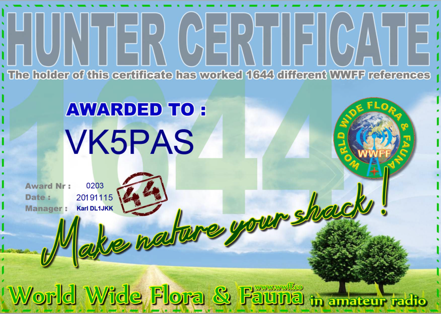
I received my latest WWFF global certificate last night for working a total of 1,644 references.
Thank you to all of the activators and thank you to Karl DL1JKK the Awards Manager.

I received my latest WWFF global certificate last night for working a total of 1,644 references.
Thank you to all of the activators and thank you to Karl DL1JKK the Awards Manager.
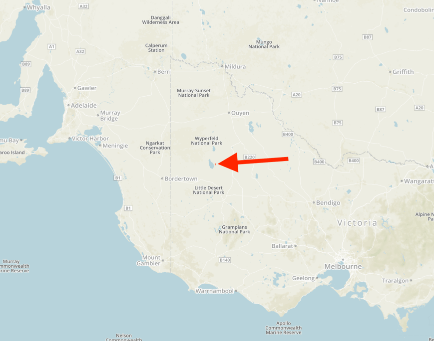
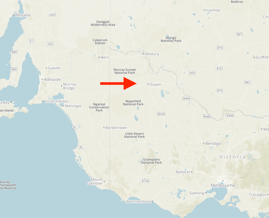
Our final park for our three-day trip away was the Ni Ni Flora & Fauna Reserve VKFF-2413. This was to be another first-time activation for the World Wide Flora & Fauna (WWFF) program.
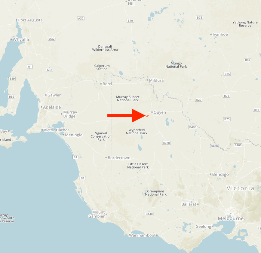
The park is located about 382 km north-west of the city of Melbourne, and about 10 km south-west of the town of Jeparit.
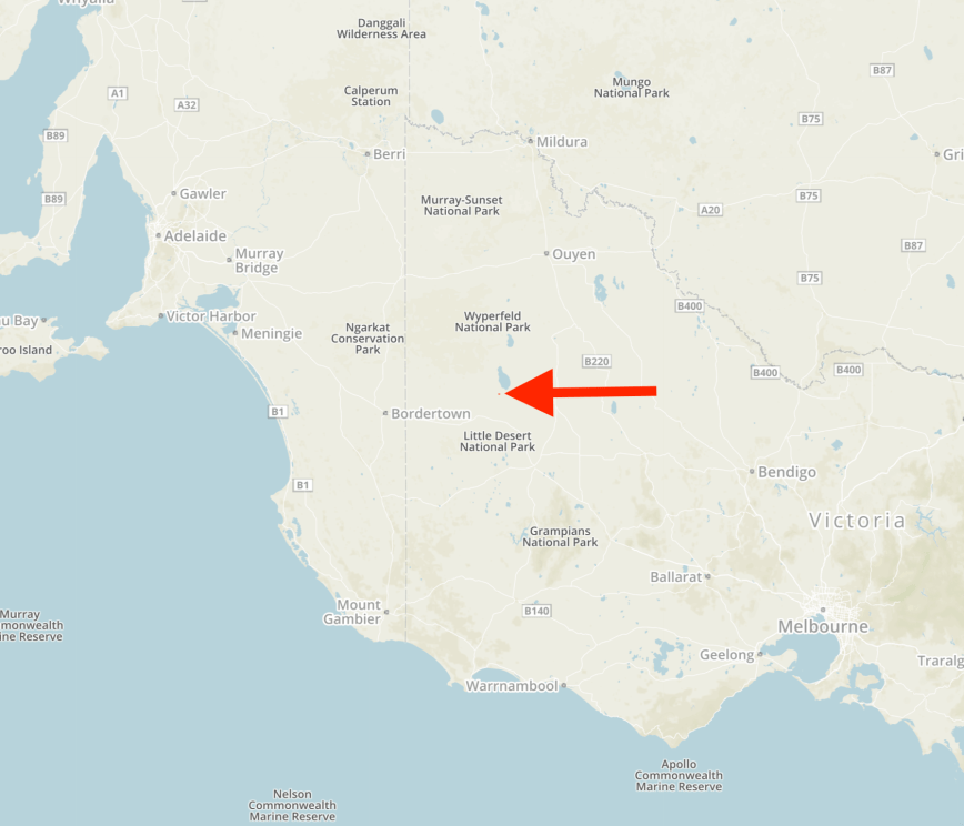
Above:- Map showing the location of the Ni Ni Flora and Fauna Reserve. Map courtesy of Protected Planet.
After leaving the Hindmarsh Flora and Fauna Reserve we drove south on the DImboola-Rainbow Road and soon reached the little town of Jeparit. It is believed that Jeparit is a corruption of a local Aboriginal word (a Gromiluk word) meaning “the home of small birds”. The town is famous due to it being the birthplace of the founder of the Liberal Party, and former Australian Prime Minister Robert Gordon Menzies. There is quite a bit to see in the town and sadly we had very little time. It will be another return trip to have a much better look around.


We continued south out of Jeparit in the Dimboola-Rainbow Road and then turned right onto Flavel Road. We soon reached the Ni Ni Flora & Fauna Reserve. The park is also referred to on maps as the Ni Ni Nature Conservation Reserve. Interestingly Protected Planet also has it as the Babatchio Bushland Reserve.
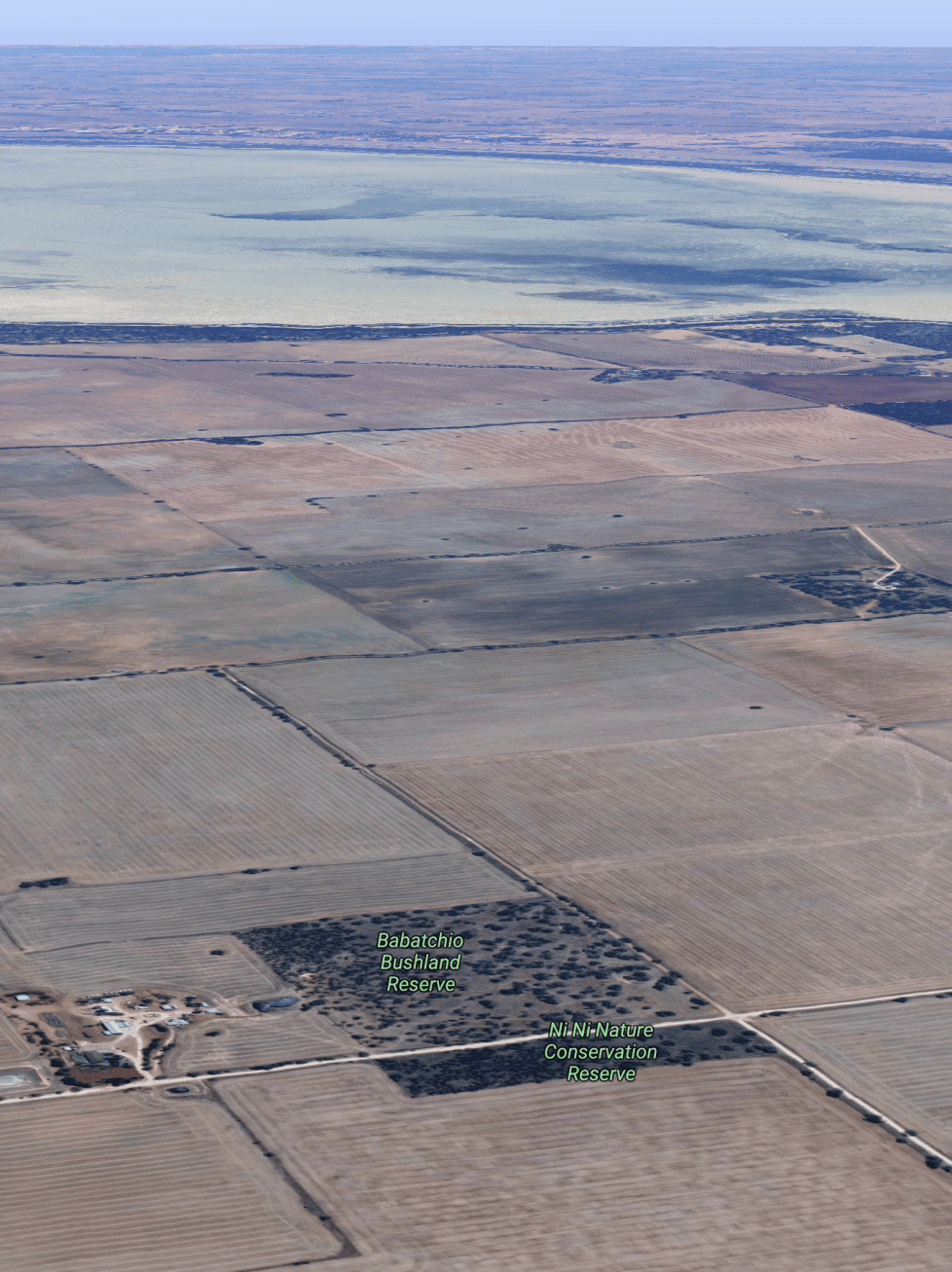
Above:- An aerial view of the Ni Ni Flora and Fauna Reserve with Lake Hindmarsh in the background. Image courtesy of Google maps
The park is about 10 acres in size and was established in 1990. It is surrounded by cleared farming land and is located on the southwestern corner of Flavel Road and Pumpa Road.


A short distance from the park you can view the cairn marking the location of the Allanby State School (Hindmarsh South) which operated from 1889-1926.


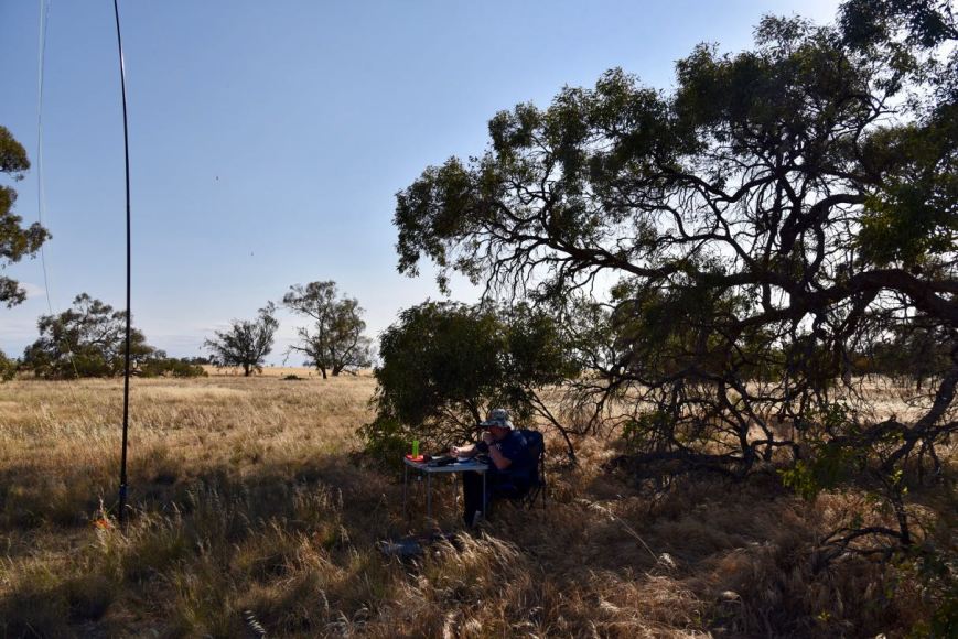
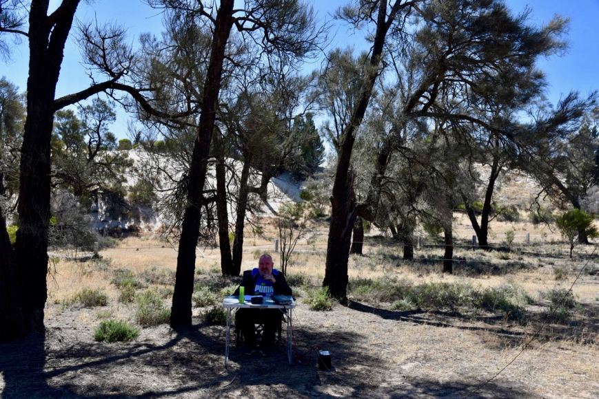
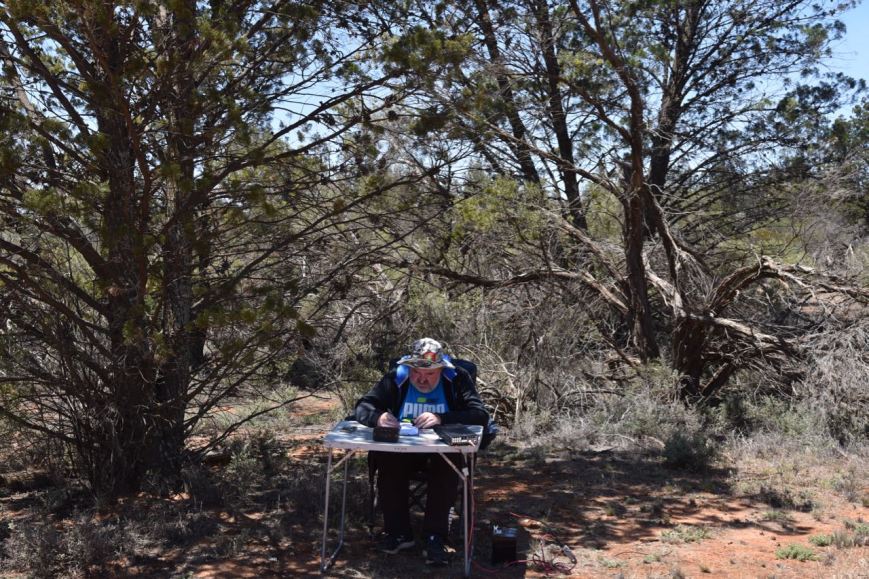
We parked the car on Flavel Road and climbed the fence and set up in the north-eastern corner of the park.
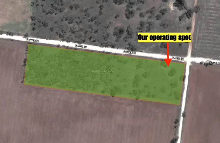
Above:- An aerial view of the Ni Ni Flora & Fauna Reserve showing our operating spot. Image courtesy of Protected Planet.
I called CQ on 7.140 and first in the log was park regular (both activator and hunter) Rob VK2VH, followed by two other regulars, Grant VK2LX, and Adrian VK5FANA. Within five minutes I had ten contacts in the log and the park qualified for VKFF. QSO number ten was with Steve VK3MPR.
Two contacts later I was very surprised to be called by Theo OT4A in Belgium, in amongst the VK stations that were calling. Theo was 5/8 and gave me a 5/5 signal report into Europe.
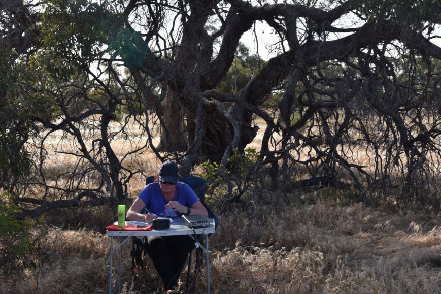
I logged a total of 26 stations on 40m before swapping the mic with Marija.
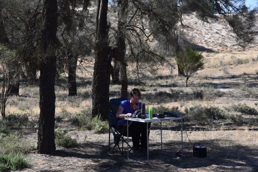
Marija’s first contact was with Rob VK2VH, followed by Geoff VK3SQ, and then Adrian VK5FANA. It took Marija just 5 minutes to qualify the park for VKFF. Her tenth contact was with Scott VK3MCL/p.
Although we were pushed very much for time, Marija encouraged me to get back on the mic to see if I could get my 44 contacts. I logged a further 6 stations on 40m from VK3, VK5, and New Zealand, before callers completely dried up. I now had 32 contacts in the log and was 12 short of the target.
I moved to 20m where I picked up a further 14 stations which got me to 43 contacts, just one short of the 44 QSO threshold. Contacts on 20m were into VK4, VK6, and France.
I headed off the 80m band where I logged 3 stations from VK4 and VK5. Contact number 44 was with Adrian VK5FANA.
It was now about 6.00 p.m. local time and we still had about 3 & 1/2 hours to get home. We packed up and hit the road, stopping at Nhill in western Victoria for a bite to eat.
On the way home I joined the 7130 DX Net from the mobile and logged 10 stations. This included Gary ZL3SV in New Zealand who gave me a 10/9 signal. The highlight of the net was working David HC5DX in Ecuador in South America. Even Dave was surprised that I was mobile. The Codan 9350 works very well.
THANKYOU to everyone who called us on our 3 day trip to Victoria. We activated eleven parks, with many of those being first-time activations. We made a total of 635 QSOs which included 78 Park to Park contacts.
References.
Aussie Towns, 2019, <https://www.aussietowns.com.au/town/jeparit-vic>, viewed 14th November 2019
Protected Planet, 2019, <https://www.protectedplanet.net/ni-ni-f-r-nature-conservation-reserve>, viewed 14th November 2019
Our fourth planned park for Sunday (11th November 2019) was the Hindmarsh Flora & Fauna Reserve VKFF-2331. This would be the first time that the park had been activated for the World Wide Flora & Fauna (WWFF) program.
The park is located about 400 km north-west of the city of Melbourne and about 14 km south of the town of Rainbow.
Above:- Map showing the location of the Hindmarsh Flora & Fauna Reserve. Map courtesy of Protected Planet.
After leaving the Wathe Flora & Fauna Reserve we headed into the little town of Lascelles. The town was named after Edward Lascelles (1847-1917) who was a passionate supporter of the district. Lascelles promoted closer settlement, was involved in water management in the area, built a large home and was a promoter of the idea that the Wimmera Mallee would be excellent grain-growing country.
Little remains in the town now. The centrepiece is the impressive hotel which was built in 1905. The pub looked very inviting, but we were a bit pressed for time. Both Marija and I agreed that we would need to come back here sometime to check it out.


The main attraction in Lascelles is the silos which are part of the Victorian Silo Art Trail. The two images of local farming couple Geoff and Merrilyn Horman were painted by Melbourne artist Rone. The work on the 1939 built silos was completed in 2017.


We then turned off the Sunraysia Highway onto the Henty Highway which is named in honour of the Henty brothers who were the first permanent land-based settlers in Victoria, taking up land at Portland in 1834.
We soon reached the town of Hopetoun where we planned to stop for lunch. Hopetoun was named after the 7th Earl of Hopetoun, the Governor of Victoria from 1899 to 1895, and later the first Governor-General of Australia. It is a beautiful little town located on the shores of Lake Lascelles.
We bought some lunch from one of the local cafes and headed down to Lake Lascelles and enjoyed some of the beautiful afternoon sun.


After lunch, we had a quick look at Corrong Homestead in Hopetoun. Unfortunately, the homestead was closed but we did have a quick look around the grounds. In 1846 Peter McGinnis guided by a friendly aboriginal followed what is now known as the Yarriambiack Creek from Horsham to Lake Corrong looking for unoccupied land for sheep grazing. He was the first European pastoralist to settle in the Mallee. He was joined by his wife, family and partner George Bell and established the Lake Corrong Run.
We continued south on the Henty Highway to the little town of Roseberry. The town was named after Archibald Philip Primrose, 5th Earl of Rosebery who toured Australia from September 1883 to January 1884, and became the British Prime Minister from 1894-1895.
There is another impressive piece of silo art in this town. The Roseberry mural was painted by Melbourne artist Kaff-eine. The two images are of a young female farmer in a work shirt, jeans and cowboy boots. The other is of a horseman in an Akubra hat, bogs boots and an oilskin vest, with his horse.


We continued south and out next stop was the town of Beaulah. Isaiah 62:4 in the Bible was the inspiration the McKenzie family, devout local Presbyterians, took when they named this tiny town Beulah in 1891.
“Thou shalt no more be termed Forsaken; neither shall thy land any more be termed Desolate: but thou shalt be called Hephzibah, and thy land Beulah: for the Lord delighteth in thee, and thy land shall be married.”


We continued further south on the Henty Highway until we reach Galaquil. There is a cairn here which commemorates the construction of the dog netting fence which crossed the highway at this point. The fence was erected in 1885 from Tyntynder to the South Australian border to prevent dingoes and rabbits overrunning and devastating pastoral and agricultural land to the south.


Our next stop was the town of Brim to have a look at their silo art mural. It is believed that Brim is a local Aboriginal word meaning “a spring” or “a well”. The images of four farmers were painted on the disused Brim silos in 2015 by Guido van Helten.


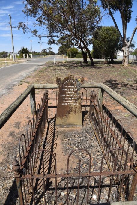
An interesting stop in the town of Brim is the solitary grave of James Simson, formerly a Commander in the Honourable East India Company Service. He died in 1858 as a result of being gored by a bullock. His grave, which can now be located in Simson Street, is the only defined grave left of the Brim Station Cemetery.
We then drove back north along the Henty Highway and turned left onto the Birchip-Rainbow Road. Our next stop was the town of Rainbow which was named after a property in the area called ‘Rainbow Rise’ which, in turn, had been named because it was located near a crescent-shaped ridge which in spring was ablaze with multicoloured wildflowers.
This looked like a great little town to explore and it was our first time there. Sadly we were running short of time. This was placed on our ‘must return to’ list.
We headed south out of Rainbow on the Dimboola-Rainbow Road and soon reached the Hindmarsh Flora and Fauna Reserve. The reserve is about 472 acres in size and is located just to the east of Lake Hindmarsh.


This was not an overly easy park to access. The only access point we could find was off the Dimboola-Rainbow Road. There is a small section of scrub which abuts the road. But, this is not part of the park. We had to drag the gear through this little bit of scrub and into the park. It was a hot day and we weren’t keen on tramping through the long grass.
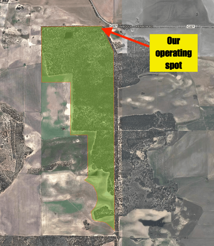
Above:- An aerial view of the Hindmarsh Flora & Fauna Reserve showing our operating spot. Image courtesy of Protected Planet.
Marija and I decided that this was going to be a very quick 40m activation and then hit the road. I called CQ on 7.150 and logged Rob VK2VH, followed by Ray VK4NH, and then Lee VK2LEE. It took me just 5 minutes to get the required 10 contacts to qualify the park for VKFF. Contact number ten was with Peter VK3PF/p who was activating the Baranduda Regional Park VKFF-0959.
I then swapped the mic with Marija, who also logged the Park to Park contact with Peter VK3PF/p. Marija’s next contact was with Lee VK2LEE, followed by Linda VK7QP, and then Rob VK2VH. It took just 7 minutes for Marija to have her 10th contact in the log, a contact with Ray ZL4TY/VK4.


We were really pushed for time and hoped to squeeze in one more park activation, so we packed up and headed off to the next park. We apologise to anyone who did not get this park in the log. We will return at some time in the near future.
Marija worked the following stations on 40m SSB:-
I worked the following stations on 40m SSB:-
References.
Aussie Towns, 2019, <http://www.aussietowns.com.au/town/lascelles-vic>, viewed 14th November 2019
Aussie Towns, 2019, <https://www.aussietowns.com.au/town/rosebery-vic>, viewed 14th November 2019
Aussie Towns, 2019, <https://www.aussietowns.com.au/town/beulah-vic>, viewed 14th November 2019
Aussie Towns, 2019, <https://www.aussietowns.com.au/town/brim-vic>, viewed 14th November 2019
Aussie Towns, 2019, <http://www.aussietowns.com.au/town/rainbow-vic>, viewed 14th November 2019
Protected Planet, 2019, <https://www.protectedplanet.net/search?q=hindmarsh>, viewed 14th November 2019
Wikipedia, 2019, <https://en.wikipedia.org/wiki/Hopetoun,_Victoria>, viewed 14th November 2019
Yarriambiack Shire Council, 2019, <https://yarriambiack.vic.gov.au/tourism/hopetoun/>, viewed 14th November 2019
Yarriambiack Shire Council, 2019, <https://yarriambiack.vic.gov.au/tourism/brim/>, viewed 14th November 2019
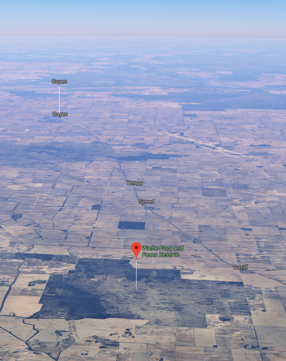
Our third park for Sunday (11th November 2019) was the Wathe Flora & Fauna Reserve VKFF-2480. This would be only the second time that the park has been activated for the World Wide Flora Fauna (WWFF) program, and the first time that it had been activated by Marija and me.
The park is located about 40 km north-west of the city of Melbourne.
Above:- Map showing the location of the Wathe Flora and Fauna Reserve. Map courtesy of Protected Planet.
We accessed the park via Wathe Reserve Road which runs off the Sunraysia Highway. This ‘road’ travels through farmers paddocks to the park boundary where you will find a set of unlocked gates.


You can continue on the other side of the gates. Depending on which maps you look at, the sandy track is either referred to as Wathe Reserve Road or Clay Road. It was a hot day and the track was very sandy and boggy. We decided not to go deep into the park.

Above:- Clay Road (or Wathe Reserve Road) which dissects the park.
This is a large park consisting of 14,816 acres of remnant mallee country. The reserve was established in 1979.


The reserve is surrounded by cleared farming land.
Above:- An aerial shot of the park looking north. Image courtesy of Google maps.
During our visit to the park, we spotted some Songlarks (I think) and White-fronted Chats.


We set up on the northern side of Clay Road on the western boundary of the park. There was plenty of room here to string out the 20/40/80 m linked dipole and just enough shade to get out of the hot sun.
Above:- An aerial shot of the Wathe Flora & Fauna Reserve showing our operating spot in the eastern section of the park. Image courtesy of Protected Planet.
For this activation, Marija and I decided to stay to her 10 watts PEP Foundation level and swap the mic as we logged stations. We called CQ on 7.135 and first in the log was Adrian VK5FANA, followed by Linda VK7QP, and then Ray VK4NH. It took us about 10 minutes for each of us to get 10 contacts in the log, thus qualifying the park for VKFF. Contact number ten was with Grant VK2LX with his big 5/9 signal.

I logged 14 stations on 40m, whilst Marija logged 11 stations. This included Park to Park contacts with David VK5DG/3 (and Vk3TUN) in the Errinundra National Park VKFF-0158.
I then moved to 14.310 on the 20m band where much to my surprise I logged a total of 14 stations from VK2, VK4, and VK7. We also put out some calls on the 80m band on 3.610 but had no takers.

So, with another park qualified for VKFF, and our tummies rumbling, we headed off for some lunch in Hopetoun.
Marija worked the following stations on 40m SSB:-
I worked the following stations on 40m SSB:-
I worked the following stations on 20m SSB:-
References.
Protected Planet, 2019, <https://www.protectedplanet.net/wathe-f-f-r-nature-conservation-reserve>, viewed 14th November 2019
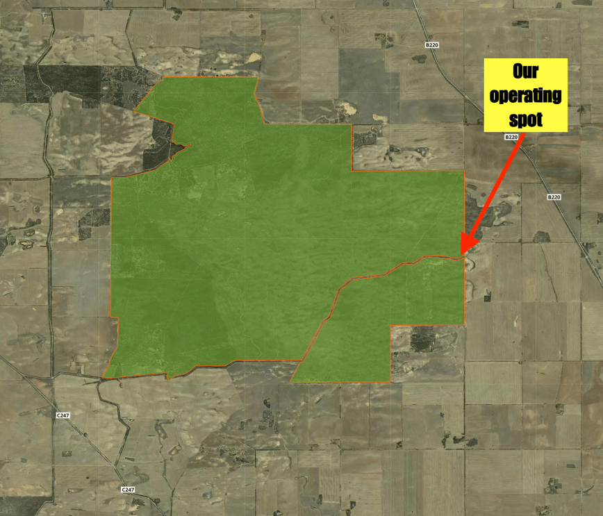
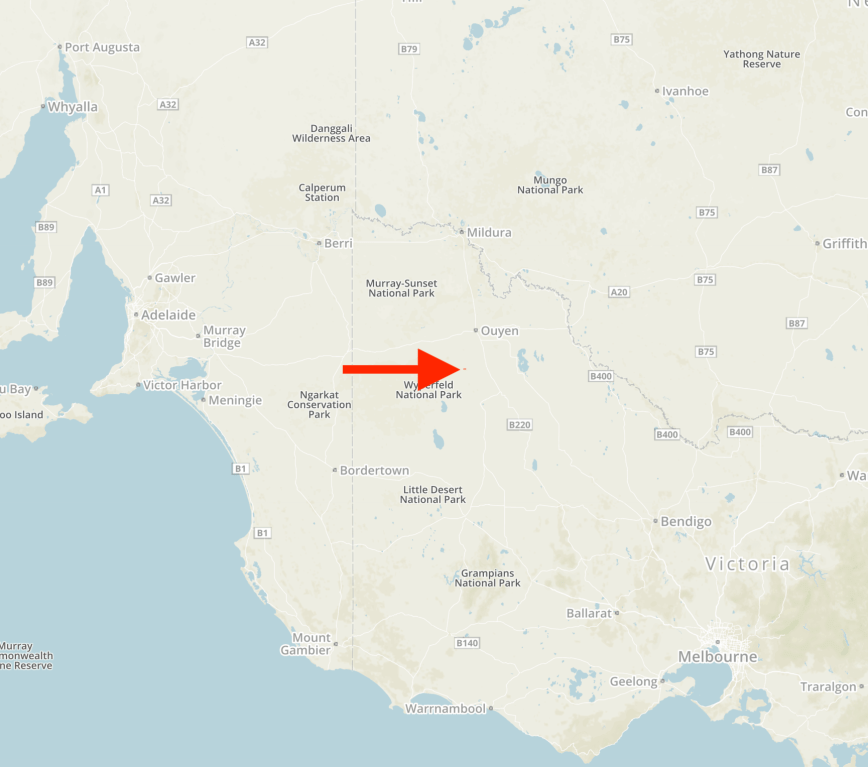
Our next intended park for the day was the Turriff Flora and Fauna Reserve VKFF-2466. This was to be the first time the park had been activated for the World Wide Flora Fauna (WWFF) program.
The park is located about 390 km north-west of Melbourne.
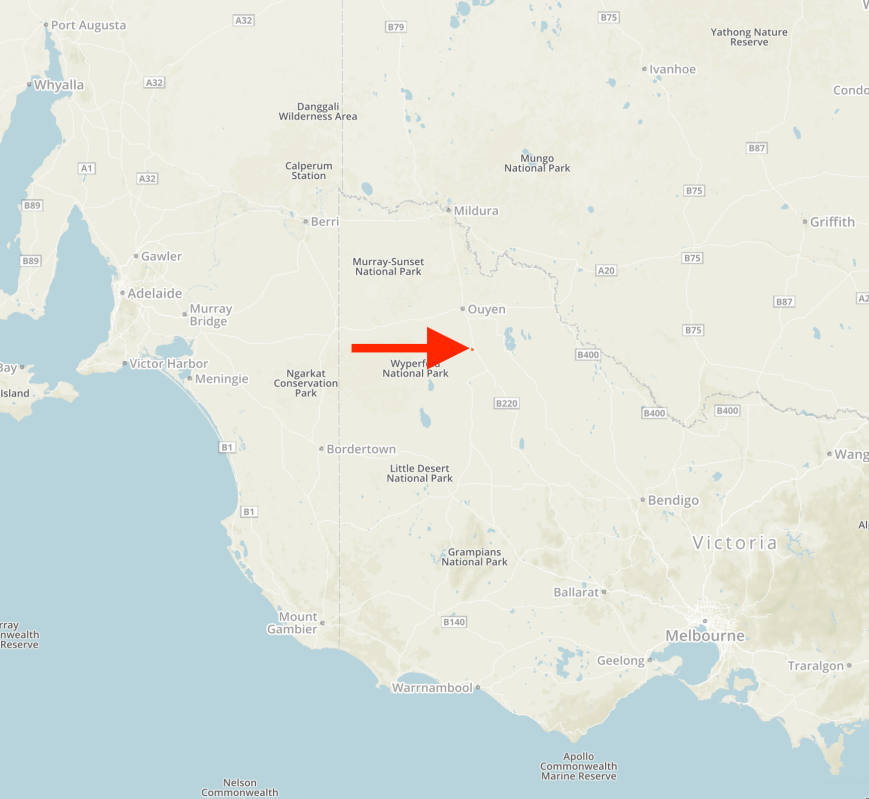
Above:- Map showing the location of the Turriff Flora & Fauna Reserve. Map courtesy of Protected Planet.
To get to the park we travelled east out of Patchewollock on the Patchewollock-Sea Lake Road. We soon reached the little town of Speed which was named after William, Harold and Gordon Speed, who settled in the district in 1903. Speed is the venue of the Mallee Machinery Field Days, first held in 1979. It is run over two days in August and has over 8,000 people attend. The normal population of the town is only about 100 people.


The Turriff Flora and Fauna Reserve is about 617 acres in size and was established in 1981. The park takes its name from the locality of Turriff which was settled in 1902. In 1994 a meteorite with a mass of 0.28 kilograms (0.62 lb) was found in a field near Turriff.


The park is named after the nearby town of Turriff. In 1901 the first settlers came to the Malle area where the town of Turriff was later named after Mr John Turriff, the Manager of Corrong Station. There was no permanent water, no telephone, and roads were just sandy tracks. In 1902-1903 the railway line was constructed through thick mallee scrub from Woomerlang to Nowingi. The SEC power came in 1964. In about 1912, 17,000 km of open channel was constructed by horse teams and scoops, which brought water to the are from storage in the Grampians. This was completed in 1920. Channels ran once a year to fill dams.


We accessed the park via Roberts Road which runs off the Sunraysia Highway.
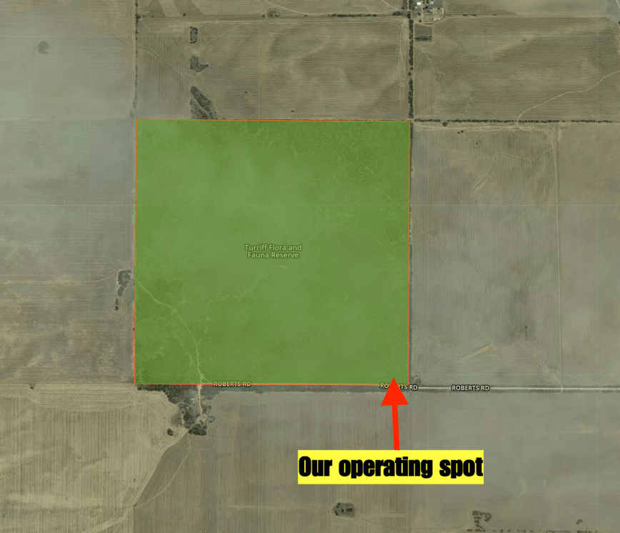
Above:- An aerial view of the Turriff Flora & Fauna Reserve showing our operating spot. Image courtesy of Protected Planet.
The VK6 guys were still on 7.145, so once again I called CQ on 7.140. First in the log was Grant VK2LX, followed by Adrian VK5FANA, and then Ray VK4NH. Once I had ten contacts in the log I swapped the mic with Marija.

Marija’s first contact was with Steve VK5KSW on the Yorke Peninsula, followed by Peter VK3PF/m, and then Adrian VK5FANA. It only took Marija about 9 minutes to get her tenth contact which was with Ian VK3VDX.

I then jumped onto the mic and logged a further two stations on 40m, before moving to the 20m band. I there logged just the one station, Adam VK2YK. Marija and I then moved to 80m where we spoke with Liz VK2XSE/p who was activating the Jerilderie Nature Reserve VKFF-1942. I then moved down to 3.610 and logged Rob VK2VH.
We were a bit pressed for time, so we packed up and headed off to our next park. We had qualified another new park for VKFF.
Marija worked the following stations on 40m SSB:-
Marija worked the following station on 80m SSB:-
I worked the following stations on 40m SSB:-
I worked the following stations on 20m SSB:-
I worked the following stations on 80m SSB:-
References.
Protected Planet, 2019, <https://www.protectedplanet.net/search?q=turriff>, viewed 13th November 2019
Wikipedia, 2019, <https://en.wikipedia.org/wiki/Speed,_Victoria>, viewed 13th November 2019
Wikipedia, 2019, <https://en.wikipedia.org/wiki/Turriff,_Victoria>, viewed 13th November 2019
It was now Monday 11th November 2019 and our two nights at Murrayville had come to an end. Our plan for today was to try to activate as many parks as possible and also to fit in quite a bit of sightseeing. With respect to the parks, we intended just to qualify them for VKFF with 10 contacts, and to come back another day for the 44 QSOs required for WWFF global qualification.
We enjoy our trips to Murrayville. It is just a little town, but we always find the locals very friendly and the accommodation at the Murrayville Caravan Park is top-notch.
Murrayville was named after John Murray (1851-1916) the Premier of Victoria from 1909-1912.
The town is a shadow of its former self. Many of the shops in the town’s main street are closed. In its heyday, it was largest of several settlements west of Ouyen. In 1933 the town’s population was 603.


The Murrayville Hotel dates back to 1911. We have always enjoyed our meals there. The old fruit and vegetable shop which is now the Cobb & Co Cafe is also one of our regular haunts when we visit Murrayville. At the eastern end of the town, you can view some old rusting army tanks.


Our first park of the day was the Yetmans Flora and Fauna Reserve VKFF-2502, which is located about 440 km north-west of Melbourne.
This was to be only the second time that this park had been activated for the World Wide Flora Fauna (WWFF) program. It was the first time for Marija and I.
Above:- Map showing the location of the Yetmans Flora & Fauna Reserve in north-western Victoria. Map courtesy of Protected Planet.
We travelled east on the Mallee Highway and then turned left onto the Hopetoun-Walpeup Road to travel south. Along the way, I spotted a Wedge-tailed eagle in a gum tree about 300 metres off the road. The photos below were captured as it was flying off.


The Yetmans Flora and Fauna Reserve is about 593 hectares in size and was established in 1986. It was clear from the park sign that the authorities have not been out to this park for a long time.


We accessed the park on its northern boundary on Woollards Road. We found a gap in the scrub with enough room to pull off the road and set up our station.
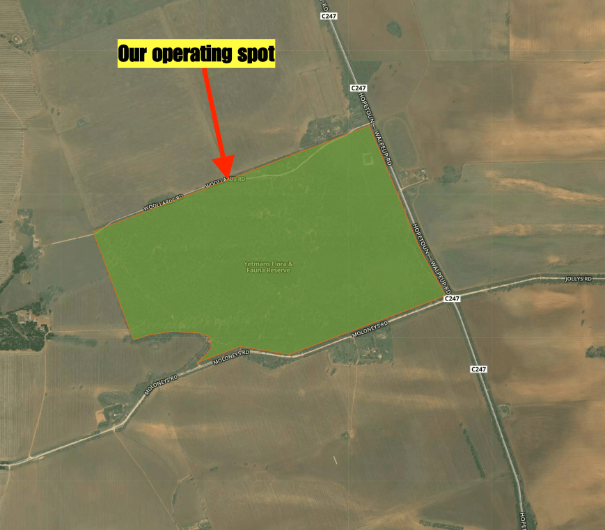
Above:- An aerial view of the Yetmans Flora & Fauna Reserve showing our operating spot. Image courtesy of Protected Planet.
There were a couple of VK6 stations talking on 7.145 so I headed down to 7.140 and called CQ. Brenton VK3CM came back to my call with a very big 5/9 plus signal. This was followed by Adam VK2YK and Rod VK7FRJG.
The 40m band was in poor shape and it took me 15 minutes to get 10 contacts in the log, qualifying the park for VKFF. I logged 11 stations before swapping the mic with Marija.

Marija called CQ on 7.140 and this was answered by Alan VK3ARH, followed by Lee VK2LEE, and then Adrian VK5FANA. It took Marija only 6 minutes to get her 10 contacts. QSO number ten was with Rob VK4AAC/2. Marija logged a further two stations before handing me back the mic.
I then logged a further 4 stations on 40m before heading down to the 80m band. Unfortunately, I was only able to log the single station on 80m, that being David VK5PL. To conclude the activation I moved up to the 20m band where I logged two stations, Lee VK2LEE and Brett VK2VW.


With the park qualified for VKFF, Marija and I packed up and once again hit the road, heading for our next park.
Marija worked the following stations on 40m SSB:-
I worked the following stations on 40m SSB:-
I worked the following station on 80m SSB:-
I worked the following stations on 20m SSB:-
References.
Protected Planet, 2019, <https://www.protectedplanet.net/search?q=yetmans>, viewed 13th November 2019
Victorian Places, 2019, <https://www.victorianplaces.com.au/murrayville>, viewed 13th December 2019
Our third and final park for Sunday (10th November 2019) was the Wyperfeld National Park VKFF-0549. This would be our second Victorian National Park for the 2019 Keith Roget Memorial National Parks Award (KRMNPA) Activation Weekend.
The park is located about 450 km north-west of Melbourne and is located in the Mallee district of north-western Victoria.
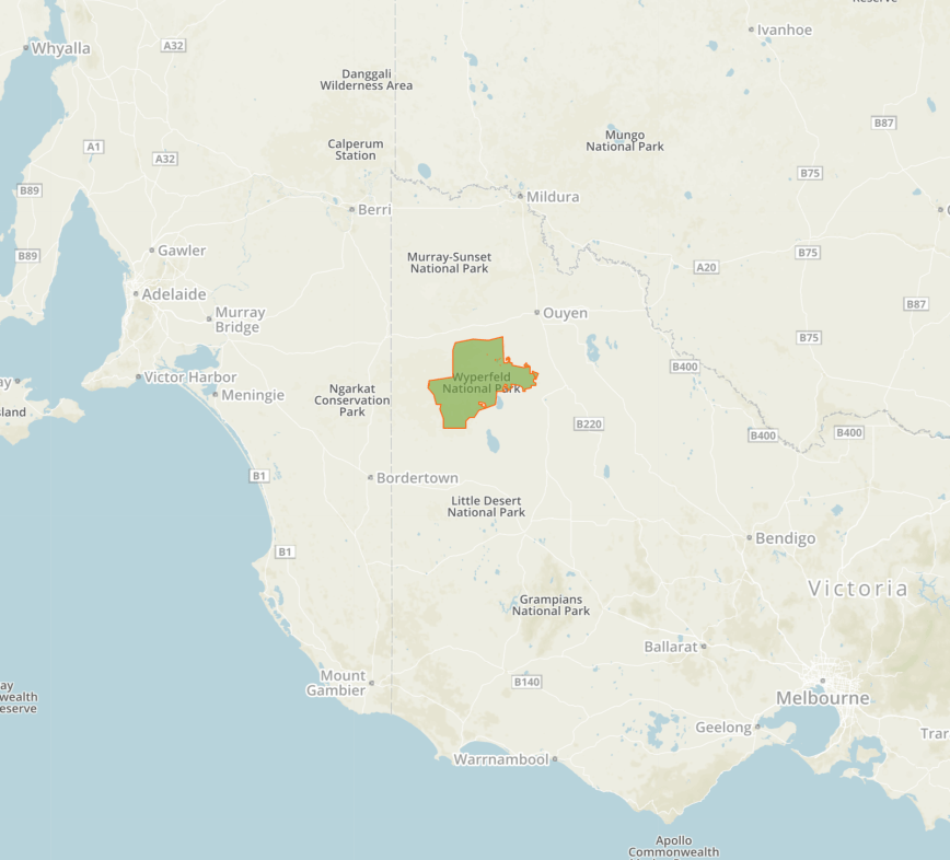
Above:- Map showing the location of the Wyperfeld National Park in western Victoria. Map courtesy of Protected Planet.
We stopped briefly in the town of Patchewollock which is believed to take its name from the corruption of two aboriginal words ‘putje’ meaning ‘plenty’ and ‘wallah’ meaning ‘porcupine grass’. Thus ‘the place of plenty porcupine grass’.


The town contains some large Mallee Fowl sculptures which are made of corrugated iron.


Patchewollock is also part of the Silo Art Trail. Brisbane artist Fintan Magee completed the work in 2016. The work portrays an image of the archetypal Aussie farmer.


You can also view some railway buildings from a bygone era. The line to Patchewollock was officially opened on the 4th day of May 1925. Patchewollock Railway Station’s last wheat train departed on the 3rd day of July 1986 and the line closed on the 8th day of December 1986.


The Wyperfeld National Park is the third largest National Park in Victoria. It is about 357,017 hectares (882,210 acres) in size. It was declared in 1921 to protect this large piece of mallee, woodland and heathland.
The park’s name comes from the Parish of Wyperfeld. There have been numerous attempts to discover the origin of the word ‘Wyperfeld’. It is believed to come from the German ‘Wyper’, a tributary of the Rhine, and ‘Feld’, a field.
The park can be reached:
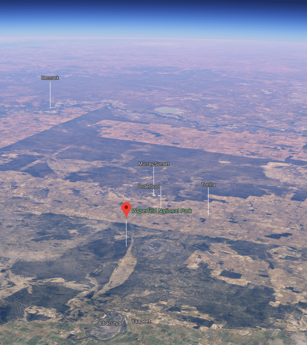
Above:- An aerial view of the Wyperfeld National Park looking north. Image courtesy of Google maps
Prior to European settlement in the area, the Wotjobaluk aboriginal people regularly travelled along Outlet Creek which snakes its way through the centre of the park, visiting the lakes and swamps. From the 1860s European settlers followed the same route to establish pastoral runs.
In 1909 a total of 3,900 hectares were reserved by the Victorian State Government following pressure from naturalists. In 1921 Wyperfeld National Park was proclaimed. Wyperfeld was Australia’s first Mallee National Park.
About 450 species of native plants can be found in the park. River Red Gum and Black Box woodlands cover the floodplains of Outlet Creek and its lakes. Pine-Buloke grows on nearby dunes. Mallee eucalypts cover most of the eastern section of the park.


Over 200 species of bird have been recorded in the park. Wyperfeld National Park is nationally recognised as an Important Bird Area. This is due to the area’s threatened population of Malleefowl and other species of birds including the Mallee Emu-wren.


After leaving Patchewoolock we headed west on Baring Road and then Pine Plains Road. We soon reached the eastern boundary of the park.


Last year we activated the park from the Casuarina campground. This year we decided to head to the Snowdrift campground.
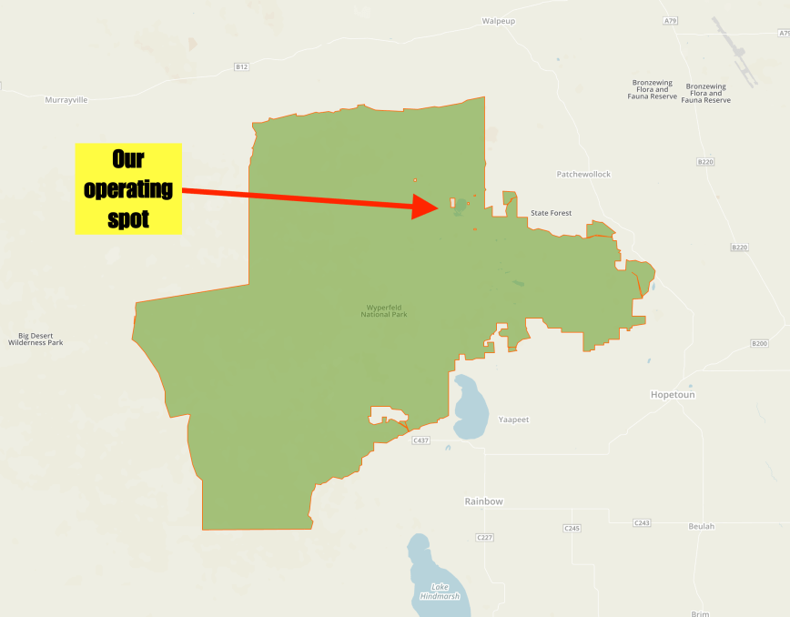
Above:- The Wyperfeld National Park showing our operating spot. Map courtesy of Protected Planet.
Snowdrift contains magnificent white sand dunes in a normally flat park.


Marija was keen enough to climb the sand dunes. There are some great views to be had of the surrounding area from the top.


After setting up Marija and I tuned across the band to see if we could hear any other park activators, but sadly we did not. In fact, the band was very quiet with very few operators. But there was a very low down station on 7.145 so I was unable to get onto 7.144. I found 7.141 clear and started to call CQ. We were unable to self spot on parksnpeaks as there was absolutely no internet coverage from within the park at our location.
It took around 3 or 4 minutes of CQ calls before the first station came back to my CQ call. It was Grant VK2LX with a big 5/9 signal. Grant kindly spotted us on parksnpeaks which resulted in a lot more traffic. Second in the log was Kieran VK2QK, followed by Graham VK7ZGK, and then a Park to Park with Gerard VK2IO/p who was activating the Dural Nature Reserve VKFF-1926. Marija also logged Gerard.
I logged a total of 12 stations on 40m before swapping the mic with Marija.
Marija called CQ on 7.141 and this was answered by Linda VK7QP, followed by Mark VK4SMA, and Scott VK4CZ. Just 5 minutes later and Marija had contact number ten in the log, with a contact with Dave VK2RP.
Marija went on to work a total of 21 stations on 40m from VK2, VK3, VK4, and VK7. This included a further Park to Park, with Peter Vk3ZPF/p who was in the Churchill National Park VKFF-0621.
Although we have both previously activated and qualified Wyperfeld, it is always nice to get your 10 or 44 contacts during an activation. Despite the band being in rather a poor shape, I was hoping to get my 44, so I hopped back into the operator’s chair.
I logged a further 33 stations including Park to Park contacts with Alan VK2MG/4 in the Samford Conservation Park VKFF-1639, Peter VK3ZPF/p in the Churchill National Park VKFF-0621, and David VK5DG/3 in the Alfred National Park VKFF-0618. Contact number 44 was with Andrew VK7DW and came in an hour and twenty minutes into the activation. Not bad considering the band conditions were poor.
I then moved up to the 20m band where I logged three stations, Mark VK3BSA mobile 6, Jonathan VK7JON and Murray VK4MWB.
Marija worked the following stations on 40m SSB:-
I worked the following stations on 40m SSB:-
I worked the following stations on 20m SSB:-
x
x
References.
Parks Victoria, 2006, Wyperfeld National Park Visitor Guide
Wikipedia, 2019, <https://en.wikipedia.org/wiki/Wyperfeld_National_Park>, viewed 13th November 2019
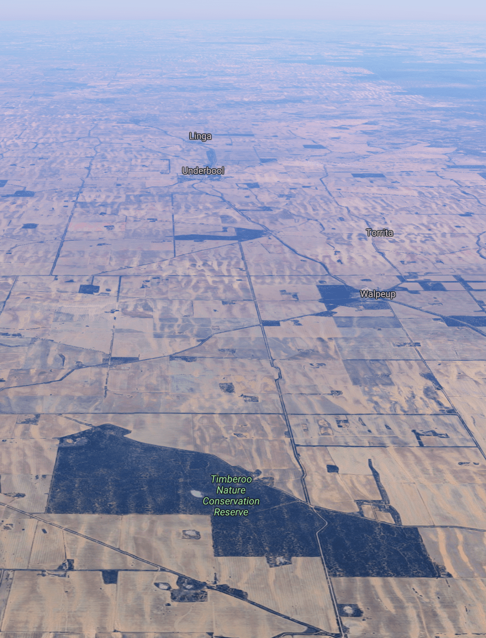
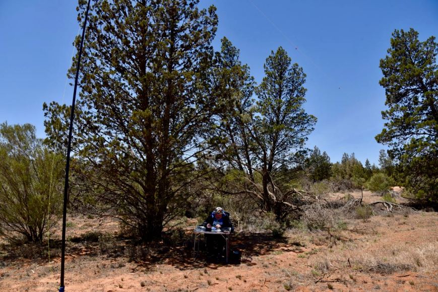
Our second park for Sunday (10th November 2019) was the Timberoo Flora and Fauna Reserve VKFF-2456. This was to be only the second time that the park had been activated for the World Wide Flora Fauna (WWFF) program. It was the first time that Marija and I had activated the park.
The park is located about 24 km south-west of the town of Ouyen in north-western Victoria.
Above:- A map showing the location of the Timberoo Flora and Fauna Reserve in north-western Victoria. Map courtesy of Protected Planet.
After leaving Kattyoong Marija and I drove east on the Mallee Highway and into the little town of Walpeup. The town’s name is derived from an aboriginal word with several meanings including ‘stumpy tailed lizard’ and the other an indigenous acacia. There isn’t much at Walpeup these days. However in its heyday in 1920 the town had a population of about 400 people, with a general store, a blacksmith, a butcher, a bank branch, and various other businesses.


The Timberoo Flora & Fauna Reserve is also referred to on maps as the Timberoo Nature Conservation Reserve. It is a large piece of remnant mallee scrub which is surrounded by cleared farming land. It is not to be confused with the much smaller Timberoo Bushland Reserve.
Above:- An aerial view of the Timberoo Flora & Fauna Reserve looking west. Image courtesy of Google Maps.
The reserve is 3,034 acres in size and was created in 1993. The reserve contains Walpeup Lake which has no water in it, and due to water no longer being piped into it, will probably remain that way for some time.


We accessed the park via Walpeup Lake Road which runs off the Hopetoun-Walpeup Road.
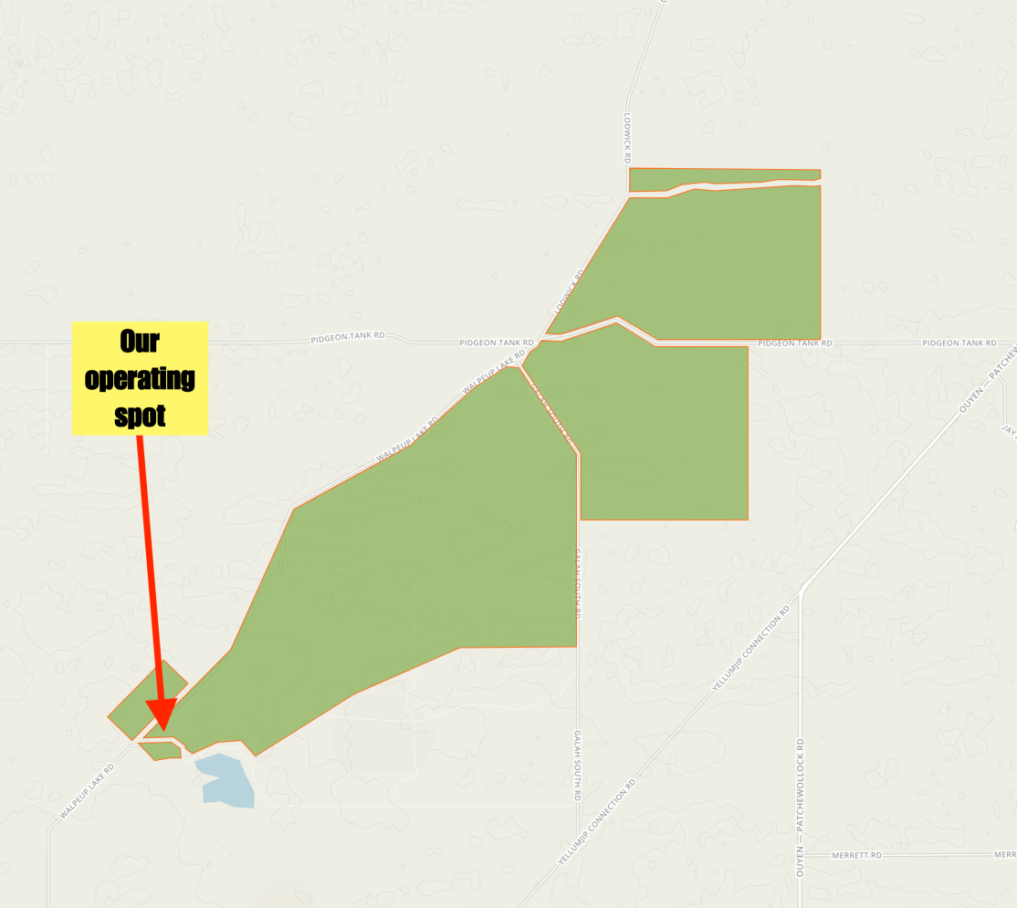
Above:- Map showing the Timberoo Flora & Fauna Reserve showing our operating spot. Map courtesy of Protected Planet.
After setting up Marija and I had a tune across the 40m band before calling CQ, hoping to track down some other park activators. Our first contact was with Peter VK3ZPF/p who was activating the Yarra Ranges National Park VKFF-0556. At the end of our QSO with Les VK5KLV asked us to go up to 7.165. We moved up the band and logged Les VK5KLV/p who was in the Franklin Harbor Marine Park VKFF-1709.
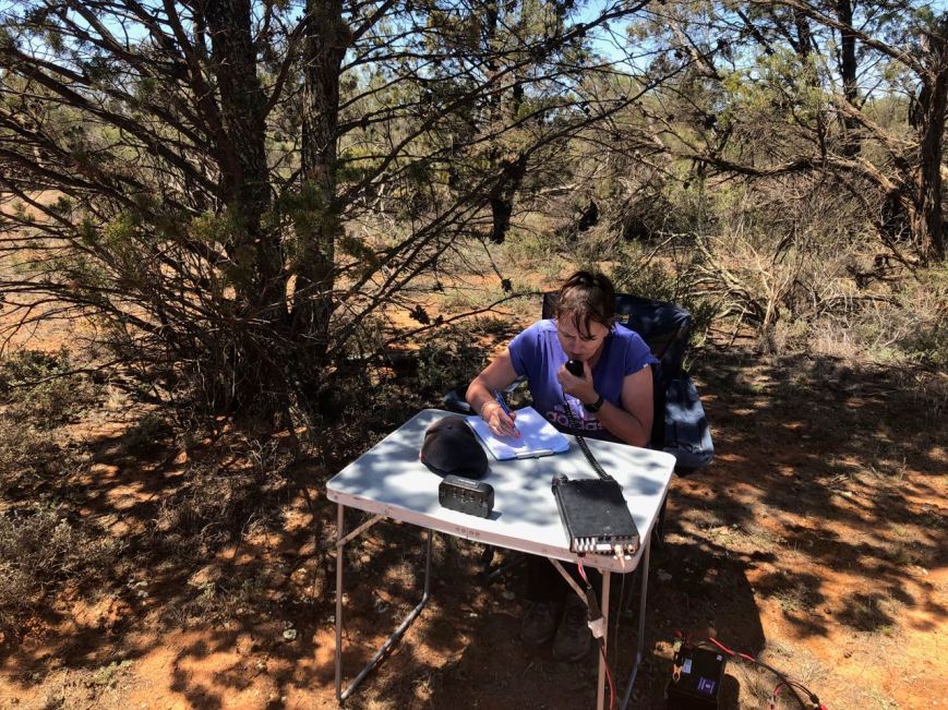
I then moved down the band to 7.144 and started calling CQ. First in the log was Lee VK2LEE, followed by Mark VK2EMI, and then Ray VK4NH. A handful of contacts later I had two more Park to Park contacts in the log: Gerard VK2IO/p who was in the Berowa Valley National Park VKFF-1162, and Shane VK2LUV/p who was activating the Belford National Park VKFF-0023.
With 21 contacts in the log, I swapped the mic with Marija. It didn’t take long and Marija had soon qualified the park for VKFF. Her tenth contact was with Adrian VK5FANA on the Yorke Peninsula. Marija logged 10 contacts including a Park to Park with Alan VK2MG/4 in the Samford Conservation Park VKFF-1639.
Marija had now qualified the park for VKFF, so I again jumped into the operator’s chair. I logged a further 6 stations with band conditions on 40m being very poor. This included a Park to Park with Alan VK2MG/4 in the Samford Conservation Park VKFF-1639.
With 27 contacts in the log, I moved to the 20m band where I logged a total of 8 stations. This included a contact with Mark VK3BSA/5 who was mobile on the Nullabor Highway.
I then moved down to the 80m band and logged 5 stations including Park to Park contacts with Peter VK3ZPF/p in the Yarra Ranges National Park VKFF-0556 and Brett VK3FLCS/p in the Terrick Terrick National Park VKFF-0630.
I then moved back to 40m and logged a further 12 stations including a Park to Park with Gerard VK2IO/p in the Dural Nature Reserve VKFF-1926.
Marija worked the following stations on 40m SSB:-
I worked the following stations on 40m SSB:-
I worked the following stations on 20m SSB:-
I worked the following stations on 80m SSB:-
References.
Victorian Places, 2019, <https://www.victorianplaces.com.au/walpeup>, viewed 13th November 2019
It was now day two (Sunday 10th November 2019) of our trip to Victoria for the 2019 KRMNPA Activation Weekend. Our plan was to activate two Flora & Fauna Reserves for WWFF, and then activate the Wyperfeld National Park for the KRMNPA weekend.
Our first park for the day was the Kattyoong Flora and Fauna Reserve VKFF-2346. The park is located about 13 km north of the little town of Torrita on the Mallee Highway in north-western Victoria.
This was the first time that the park had been activated.
Above:- Map showing the location of the Kattyoong Flora and Fauna Reserve in north-western Victoria. Map courtesy of Protected Planet.
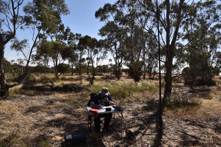
After leaving the cabin at the caravan park we headed to the Cobb & Co Cafe in Murrayville for some breakfast. Whenever we are in the area we always stop here. It is good food and good coffee. The owner is friendly and coincidentally his two sons live in our home town of Mount Barker.

Above:- Marija enjoying some breakfast at the Cobb and Co Cafe at Murrayville.
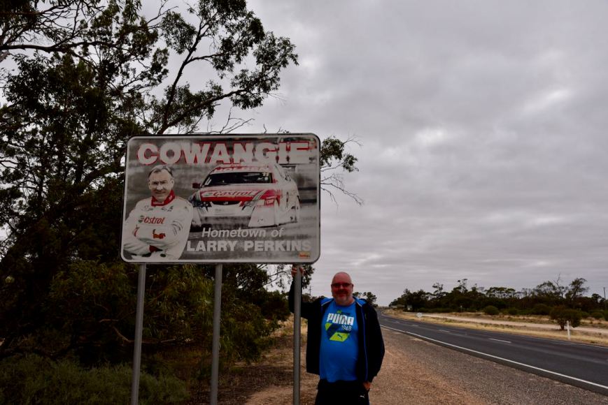
We left Murrayville after breakfast and headed east on the Mallee Highway. Our first stop was the little town of Cowangie. If you are travelling along the Mallee Highway, take the time to detour into this little town. Cowangie is the birthplace of motorsport legend Larry Perkins. He is a former racing driver and V8 Supercar team owner.
The Cowangie Post Office opened in July 1912 and was originally known as Kow Plains until 1913. The Post Office closed in 1994, and not much else remains in Cowangie from its heyday. The nearby Kopw Plains homestead is well worth a visit. However, we did not do that on this trip as we have visited there previously.
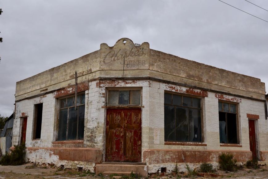
Above:- an old shop in the main street of Cowangie.
One of the buildings worthwhile having a look at whilst in Cowangie is the old Bush Nursing cottage. At a meeting of the Cowangie Bush Nursing Centre in August 1917, it was moved that a two-roomed stone cottage be erected so the nurse could live in more comfort and afford privacy to patients. The cottage was completed in 1918. The Cowangie Bush Nurse Centre ceased operation in 1924.


Another interesting place is the Cowangie Bakery which opened in 1912. The bakery closed in 1952 and in 2001 was restored.


We left Cowangie and continued east on the Mallee Highway, stopping briefly to have a look at the lone grave for a railway worker. The grave which is located in the middle of nowhere is marked on the Mallee Highway.


The highway was quite busy with trucks as this is the main highway between Adelaide and Sydney.
We then stopped briefly at the small town of Underbool. The town name is thought to come from the German word underbolt given to it by surveyor Dr Neumayer when he camped there in October 1861. A post office opened on 15 July 1912 when a regular mail service was provided by the opening of the railway from Ouyen to Murrayville a month earlier. In 1913 a school and public hall were built, while in 1917 a Bush Nursing Centre was established. By 1918 there were numerous stores and business in Underbool.
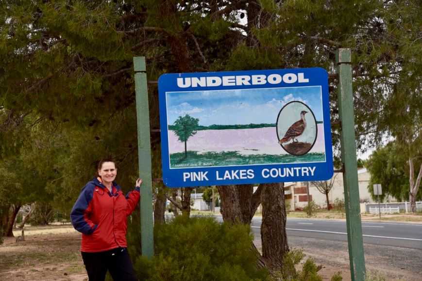
The Underbool Hotel was built in 1925 and boasted a large formal dining room, public bar, pool room and accommodation. Sadly it closed in December 2016.
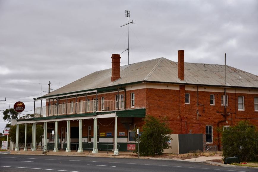
Above:- The old Undeerbool Hotel.
There are a few things of interest in the town. One of those being an old mallee scrub roller which was made from a large steam engine boiler with a heavy timber framework attached. It was used to clear the mallee scrub and was adapted to be used behind a crawler tractor. It was in use until the early 1960s.


The Pioneer and Early Settler Memorial is in honour of the pioneers of the district. There is also a replica of the train used by Sailor Salt Co. to transport salt from Lake Becking to the Linga Railway Station in the 1920s.


You can also view Underbool’s police cells that were decommissioned in 2002.


We continued on to the little town of Torrita (don’t blink, you will miss it) and then turned left onto Stones Road and then right onto Cheesmans Road and then left onto Cooke Road. The park is located at the corner of Cooke Road and Joyce Road. It is not be confused with the Kattyoong Bushland Reserve which is located nearby.
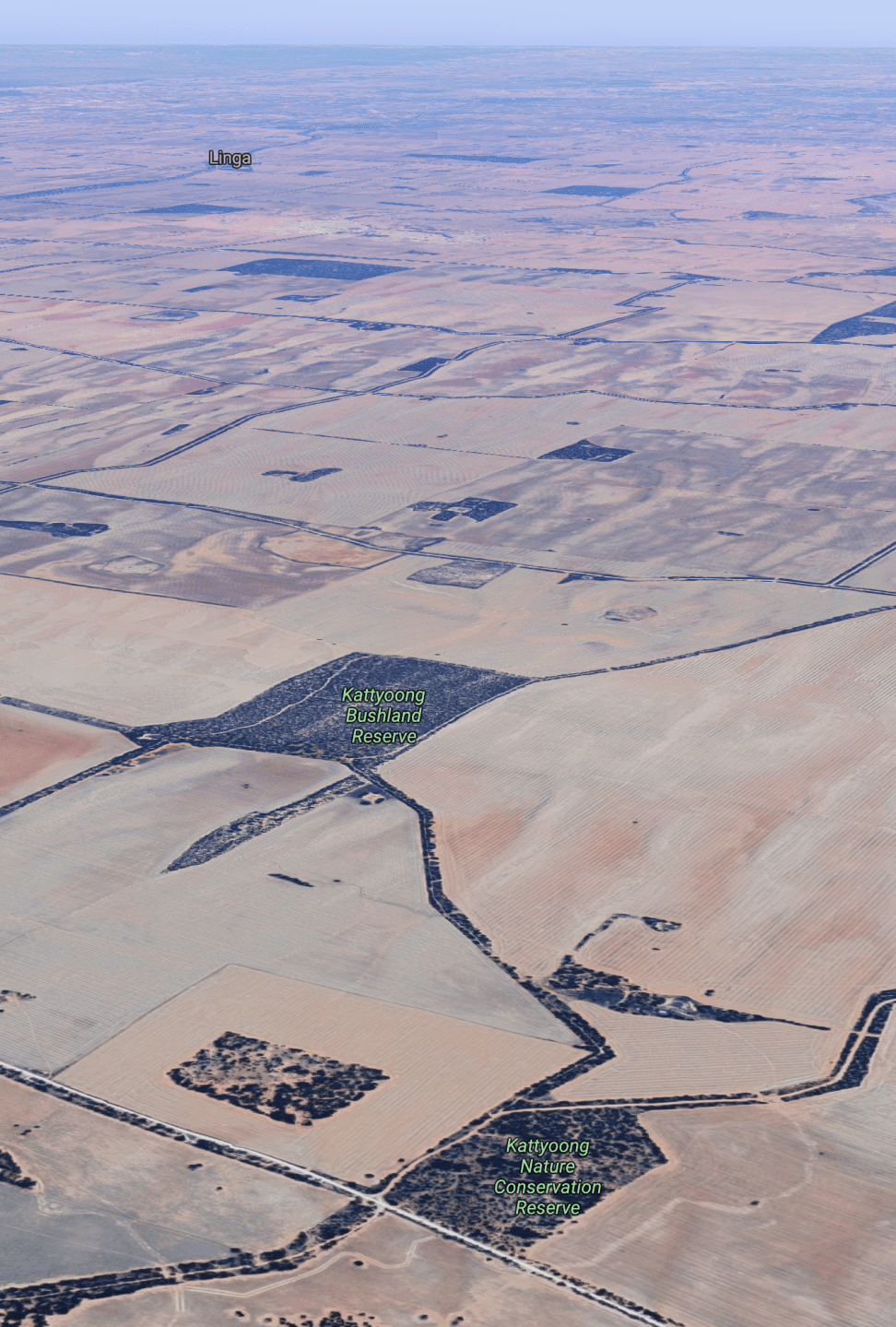
Above:- An aerial view of Kattyoong Flora & Fauna Reserve, with the Kattyoong Bushland Reserve close by. Image courtesy of Google maps
The Kattyoong Flora and Fauna Reserve is 39 acres in size and was established in 1990. It comprises typing mallee scrub.


During our visit to the park, we observed numerous Rainbow Bee Eaters. They are a strikingly brilliant bird. Rainbow bee-eaters mostly eat flying insects, but, as their name implies, they have a real taste for bees.

Marija and I could not find a suitable access point into the park on Cooke Road. We did, however, find a 4WD track leading into the park on Joyce Road. There was plenty of room to string out the 20/40/80m dipole antenna.
Above:- An aerial view of the Kattyoong Flora & Fauna Reserve showing our operating spot. Image courtesy of Protected Planet.
As this was a Sunday morning, the broadcasts for the Wireless Institute of Australia (WIA) were in full swing, so I was not able to get onto 7.144. I found 7.120 clear and started calling CQ. Ken VK3ALA was first in the log, followed by Tony VK5TT with an exceptionally strong signal, and then Mark VK3PI.
My fourth contact was a Park to Park contact with Peter VK3ZPF/p who was in the Dandenong Ranges National Park VKFF-0132. Scott VK4CZ became my 10th contact, thus qualifying the park for me for VKFF. I then logged David VK5DG/3 who was in the Coopcrambra National Park VKFF-0113.
Sadly I started to experience QRM from a VK4 station who came up on frequency, unannounced, and started calling CQ DX. Despite being told by numerous stations that the frequency was in use, he continued to call CQ DX. I apologise to anyone who was calling who I missed, as the interference was strong.
I persevered and eventually, he got the message and moved off frequency. I logged a total of 30 stations including three further Park to Park contacts with Peter VK3PF in the Chiltern Mount Pilot National Park VKFF-0620, and Joe VK3YSP/p & Julie VK3FOWL/p in the Brisbane Ranges National Park VKFF-0055.
I then swapped the mic with Marija.
Marija’s first contacts were with Joe VK3YSP/p and Julie VK3FOWL/p who were in the Brisbane Ranges National Park VKFF-0055. John VK7FJFD followed, then Ray VK4NH, and then Linda VK7QP. Marija’s 10th contact was a Park to Park with Gerard VK2IO/p who was activating the Berowra Valley National Park VKFF-1162. This was followed by another Park to Park with Tony VK3XV/p who was in the Terrick Terrick National Park VKFF-0630.
Marija logged a total of 26 contacts including two further Park to Park QSOs with Peter VK3PF/p in the Chiltern Mount Pilot National Park VKFF-0620, and David VK5DG/3 in the Coopracamba National Park VKFF-0113.

I then called CQ once again on 7.120 and logged a further 23 stations including Park to Park contacts with Peter VK3PF/p in the Chiltern Mount Pilot National Park VKFF-0620 (a new contact on a new UTC day), and Gerard VK2IO/p in the Berowra Valley National Park VKFF-1162.
With 53 contacts in the log, I moved to the 20m band and called CQ on 14.310. I logged a total of 9 stations, all bar one from Queensland. Brett VK2VW was the exception.
Marija then called CQ on 3.610 for about 5 minutes, but there were no takers.
We packed up and headed off to our next park, the Timberoo Flora and Fauna Reserve.
Marija worked the following stations on 40m SSB:-
I worked the following stations on 40m SSB:-
I worked the following stations on 20m SSB:-
References.
Protected Planet, 2019, <https://www.protectedplanet.net/kattyoong-f-r-nature-conservation-reserve>, viewed 12th November 2019
Victorian Places, 2019, <https://www.victorianplaces.com.au/underbool>, viewed 12th November 2019
Wikipedia, 2019, <https://en.wikipedia.org/wiki/Larry_Perkins>, viewed 12th November 2019
Wikipedia, 2019, <https://en.wikipedia.org/wiki/Cowangie>, viewed 12th November 2019
Wikipedia, 2019, <https://en.wikipedia.org/wiki/Underbool>, viewed 12th November 2019
Wikipedia, 2019, <https://en.wikipedia.org/wiki/Rainbow_bee-eater>, viewed 12th November 2019
Our third and final park for Saturday (9th November 2019) was the Murray Sunset National Park VKFF-0373. This was to be our first park for the 2019 Keith Roget Memorial National Parks Award weekend.
The Murray Sunset National Park is located about 500 km north-west of Melbourne.
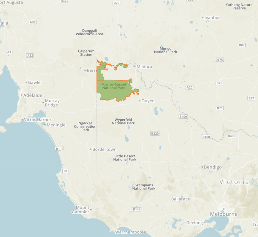
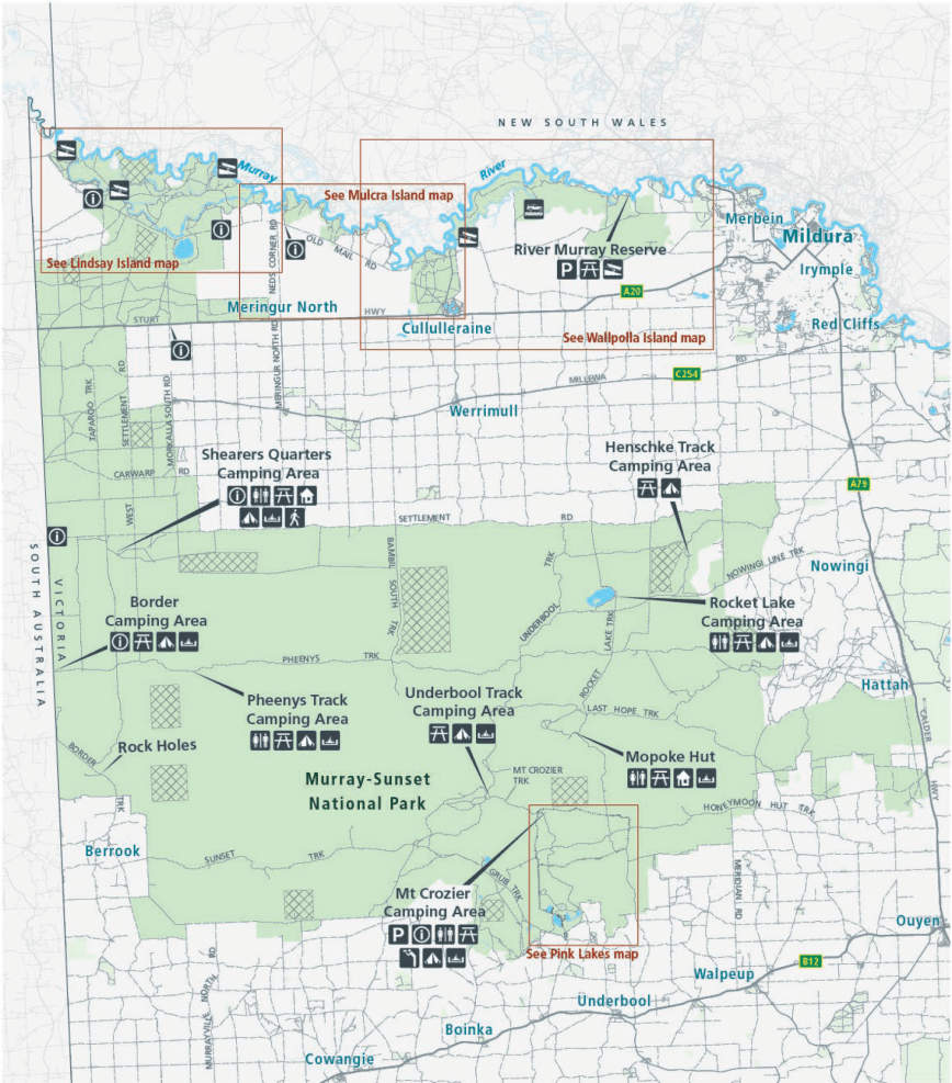
Above:- Map showing the location of the Murray Sunset National Park in north-western Victoria. Map courtesy of Protected Planet.
After leaving Gnarr Flora & Fauna Reserve we drove back into the town of Underbool and headed west on the Mallee Highway until we reached Linga where we took Pink Lakes Road. We headed north and about 18 km up the road we reached the park. Pink Lakes Road is dirt but it is suitable for a 2WD vehicle.
On our way to the park, we logged Nik VK3ZK/p and Peter VK3PF/p from our mobile. Nik was activating the Dandenong Ranges National Park VKFF-0132, while Peter was activating the Mitta Mitta Regional Park VKFF-0974.
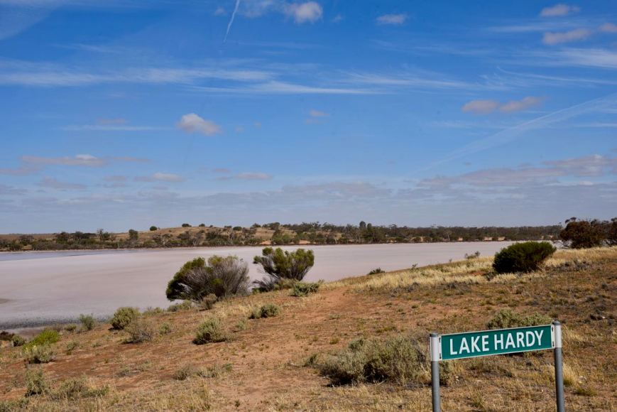
We drove into the park and travelled along Pink Lakes Road passing Lake Hardy. The lake is made of solid salt and due to the presence of red algae called Dunaliella saline, the lake often gives off a brilliant rosy-pink colour.
The Murray Sunset National Park is the second-largest National Park in the State of Victoria. The park is about 633,000-hectare (1,560,000-acre) in size and was proclaimed on the 26th day of April 1979. The park is located in the north-western corner of Victoria and borders South Australia to the west and the Murray River to the north. The Sturt Highway passes through the northern section of the park. The majority of the park is in a remote area between the Sturt Highway and the Mallee Highway, west of the Calder Highway.
Above:- Map of the Murray Sunset National Park. Map courtesy of Parks Victoria.
The majority of the park lies within the Murray-Sunset, Hattah and Annuello Important Bird Area (IBA), which was identified by BirdLife International due to it containing mallee habitat supporting a number of threatened mallee bird species, including the Mallee-fowl, Black-eared Miner and Mallee Emu-wren. Over 600 species of plants have been recorded in the park, and 300 species of birds.


We travelled the short distance to the main campground at Lake Crosbie.
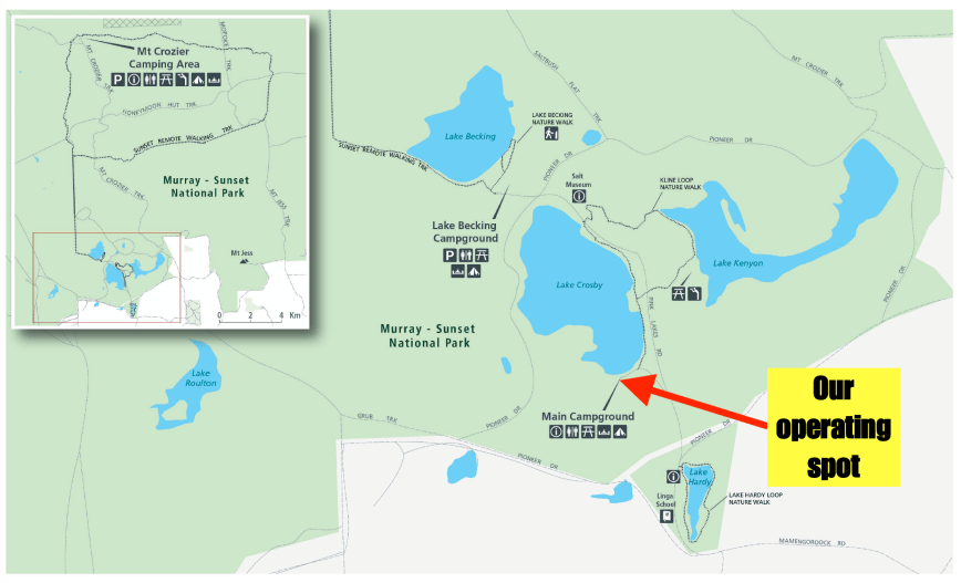
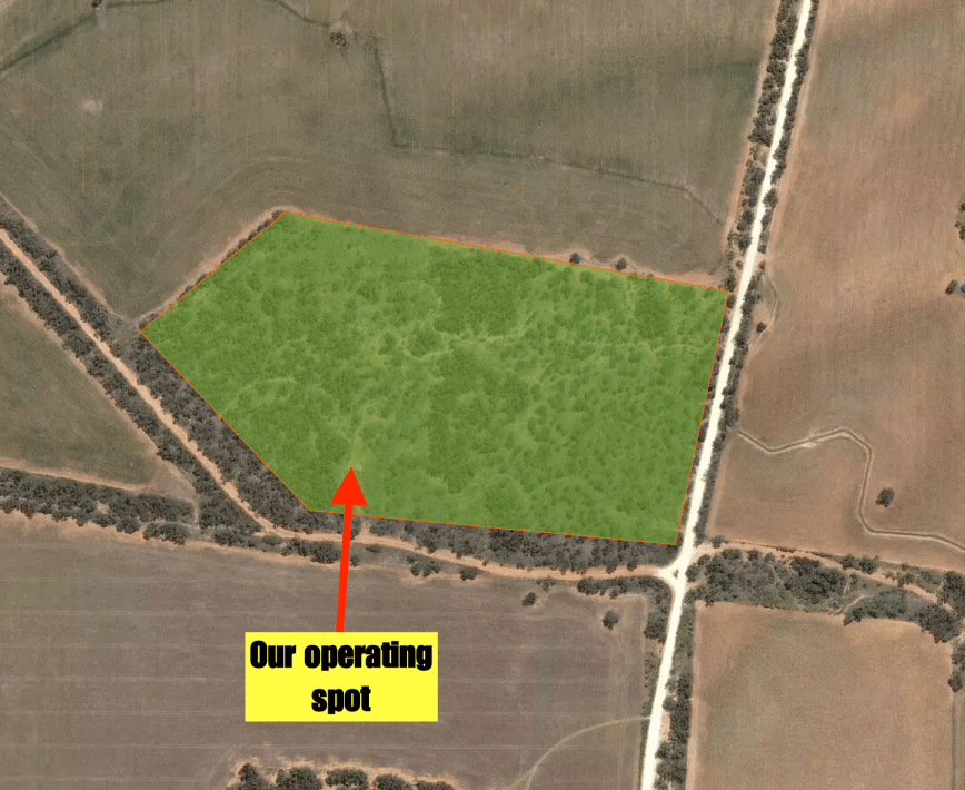
Above:- A map of the Pink Lakes area of the park showing our operating spot. Map courtesy of Parks Victoria.
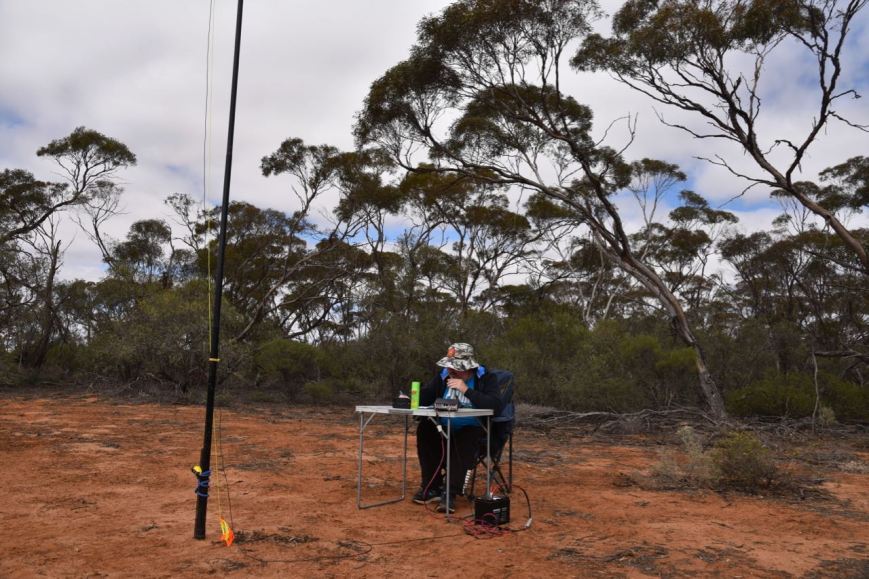
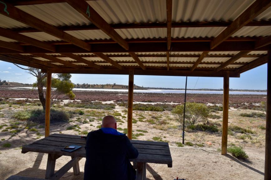
Although there were a number of caravaners and campers there, our favourite shelter shed was free and was the ideal spot to operate from. It was a very warm afternoon, so the shelter provided some valuable relief from the afternoon sun.


At the campground, you can find the Kline-loop nature walk which is 4.8 lm in length (takes about 2 hours). The walk is named after Jim Kline who was a worker who lived and worked in the area during the 1930s and 1940s. The walk follows the shore of Lake Crosbie and across pine-woodland rises to the picturesque Lake Kenyon.


Prior to calling CQ we tuned across the 40m to see if we could find some other park activators. We found Nik VK3ZK/p on 7.139 calling CQ from the Dandenong Ranges National Park VKFF-0132. Unfortunately, he was the only park activator we were able to hear, so I headed up to 7.150 and started calling CQ.
First in the log was Keith VK3MKE, followed by David VK5DWC, and then Linda VK7QP. The 40m band was in very good condition and it didn’t take long for a mini pile up to commence. I logged a total of 31 stations in a very short space of time, including the two further Park to Park contacts with Peter VK3PF/p in the Mitta Mitta Regional Park VKFF-0974, and Gerard VK2IO/p in the Cattai National Park VKFF-0092.
As I had qualified the park now for VKFF, I took the opportunity of telling all stations to stand by and swapped the mic with Marija.
Marija’s first contact was with Peter VK3PF/p in the Mitta Mitta Regional Park VKFF-0974, followed by Mike VK5FMWW, Scott VK4CZ, and then Paul VK3DBP. It didn’t take long before Marija had ten contacts in the log and the park qualified for VKFF. Contact number ten was with Greg VK2EXA.
Marija logged a total of 22 stations before handing me back the mic.
I again called CQ on 7.150 and logged a further 10n stations before callers dried up. I now had 42 contacts in the log and was just 2 short of the 44 required to qualify the park for the global WWFF program. I headed over to the 20m band where I logged 3 stations: Scott VK4CZ, Mark VK4SMA, and Murray VK4MWB.

Marija worked the following stations on 40m SSB:-
I worked the following stations on 40m SSB:-
I worked the following station on 20m SSB:-
After packing up Marija and I decided to have a drive along Pioneer Drive. We have done this before, but it is a very nice drive through the park.
We stopped briefly to have a look at the outdoor salt museum on the eastern side of Lake Crosbie. There was once a thriving commercial salt industry here, which commenced in 1916 and concluded in 1979 when the area was declared as a State Park.


Lake Crosbie is the largest of four large salt lakes in the Pink Lakes area of the Murray Sunset National Park.
Above:- Lake Crosbie
We then stopped at Lake Kenyon which was named after A.S. Kenyon who was appointed engineer-in-charge of improvements to the northern Mallee.


A little further along the drive are a number of interpretive signs which detail the history of salt mining within the park. During the 1920s and 1930s there was a small township at this location for the salt workers and their families. This included houses, a school, and Otto the cook’s underground house. Seasonal workers and local farmers also came on foot or by bicycle, horse, or car to work on salt harvesting. Camels carried sale to the railway at Underbool and Linga. A short-lived tramway was constructed but later abandoned and replaced by trucks. Salt was shovelled into bags weighing up to 180 pounds (abt 60 kg) and loaded onto trucks by hand. Very little remains today.


We then drove back to Murrayville and went out for tea at the local pub. We then headed back to the caravan park where Marija had an early night. I stayed up and watched Die Hard for about the 20th time before heading off to bed.
References.
Wikipedia, 2019, <https://en.wikipedia.org/wiki/Murray-Sunset_National_Park>, viewed 12th November 2019
Amateur Radio, Short Wave Listening, travel and history
Amateur radio experiences with VK1DA
Brisbane - Australia
german amateur radio station
Summits On The Air
SOTA on the peaks, wilderness QRP and some bushwalking
A fine WordPress.com site
Amateur Radio Adventures
Summits on the Ai
Amateur radio station from Belgium
Radio craft, homebrew, QRP/SOTA, AM
Ego loqui ad viros super montes
My adventures with Amateur Radio and Geocaching!
The rantings of VK2GAZ on his SOTA experiences in Australia
A survivor, with minor cuts and abrasions.
The Art and Craft of Blogging
The latest news on WordPress.com and the WordPress community.
Blog of Justin Giles-Clark VK7TW's SOTA and amateur radio adventures.
Occasional SOTA & Microwave operation
