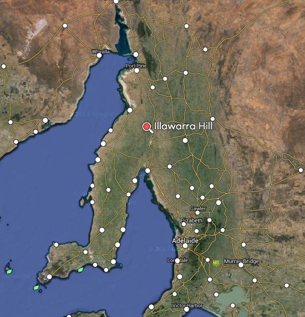
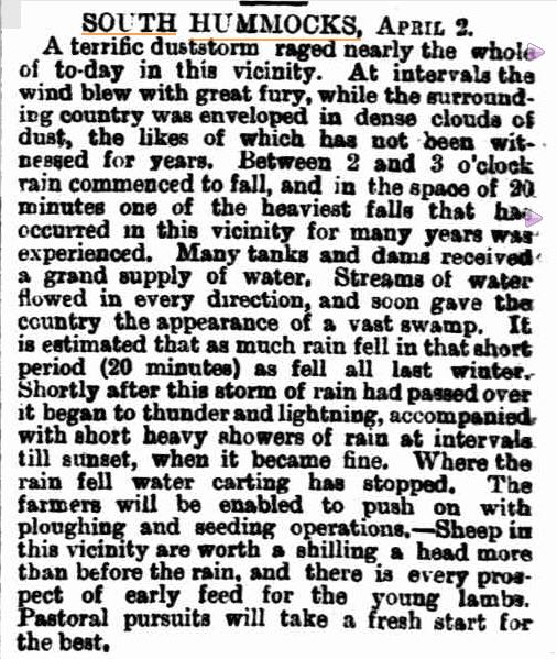
My first activation for Wednesday 4th February 2015, was New Campbell Hill, VK5/ SE-007, which is situated about 11km south of Jamestown, and about 206 km north of Adelaide.
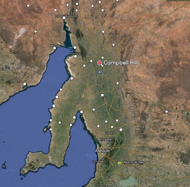
image courtesy of mapcarta.com
New Campbell Hill is 714 metres above sea level and is worth 4 SOTA points. It is located in the ‘South East’ Region of the South Australian SOTA Association, and is located in the Bundaleer Forest Reserve.
I have activated this summit once before, with Ian VK5CZ. For information on that activation please have a look at my previous post at…..
https://vk5pas.org/2013/07/27/new-campbell-hill-vk5-se-007/

New Campbell Hill is part of the Campbell Range. It is not to be confused with Campbell Hill which is located further to the south.
I had an early start from Crystal Brook and I headed north along RM Williams Way towards Jamestown. I turned left onto Bundaleer Gardens Road, and stopped briefly to have a look at the memorial for Pioneers of the Bundaleer District. I continued on up Bundaleer Gardens Road, and parked the car at Neindorf Road, where I packed my backpack, and commenced the @5 km walk to the summit.
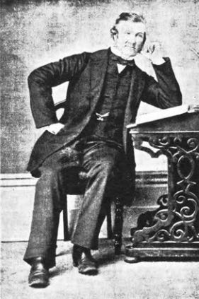
Bundaleer is regarded as the birthplace of forestry in Australia. It covers an area of about 3,200 hectares. It is still home to Curnow’s Hut, the original residence built for the district’s first nursery worker, William Curnow (see below). The name Bundaleer is derived from an aboriginal word, meaning ‘stony place’.

Map courtesy of Forestry SA.
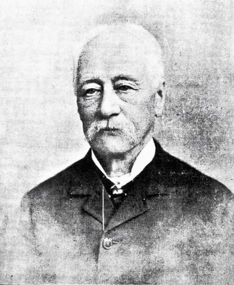
Bundaleer Forest was originally part of the Bundaleer Run, which was a vast pastoral station established in 1844 by John Bristow Hughes (b. 1871 – d. 1881). Hughes was born in England in 1817 and arrived in South Australia in 1841 aboard the Porter, following his arrival in Tasmania in 1840. He was married in 1847 in Adelaide, and established Bundaleer shortly after arriving in South Australia, with sheep he had brought across from Tasmania.
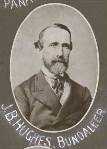
Above: J.B. Hughes. Image courtesy of http://www.samemory.sa.gov.au
In 1875, a Forest Board was appointed by the South Australian Government, and Forest Reserves were created, mainly in the South East. However, some sections were created in the north of South Australia. In c. 1876 the Forest Board commenced work at Bundaleer Springs when a nurseryman, William Curnow was sent to establish a nursery and prepare 400 hectares for lanting. Curnow commenced planting asmanian Blue gums, local Red gums and Sugar Gums adjacent to the Jamestown to Spalding Road (RM Williams Way).
I followed the Bore Track up to the summit. The walk starts off very easy, but don’t get too excited. Worse is to come. The initial walk took me passed beautiful pine forest, along a very easy access track. There were quite a few Western Grey kangaroos out, enjoying the morning sunshine. But unlike last time I activated the summit, I did not see any native deer.
The Bundaleer Forest Reserve was devastated by fire in early 2013. Around 23,000 hectares of forest and scrubland were destroyed. Over 30 % of the pine plantations were wiped out. Leith Cooper, who is a local farmer stated: ‘It was one of the worst fires I’ve ever seen, there were reports that the flames were 100 feet above 50 foot pine trees, it was pretty intense’. For more information on the fire, including some audio, please have a look at…..
http://www.abc.net.au/news/2013-05-14/charred-bundaleer-forest/4687770
There are some excellent views once you reach the top of the summit. And the amazing dry stone walls which follow the ridgeline, are really quite a sight. They are mentioned in a book called ‘those dry-stone walls’ written by Bruce Munday, which I have a copy of. Many of these old walls were created by Patrick O’Grady (1838-1906), who was a ‘waller’ on Bundaleer Station. Munday is remembered as bing ‘a little old man with long ringlets who always wore green ribbon in his coat’. He is buried with his wife Annie at the Jamestown cemetery. Local photographer, Mary-Anne Young made the following comment: ‘For someone who created such magnificent stone work, it is a disapointing grave’.
This was not one of my most memorable SOTA activations. After setting up the linked dipole, I discovered that I had a very high VSWR. Numerous checks were undertaken on the antenna, and this revealed that the likely source of the problem was the coax crimping on the BNC connector. Not much I could do about it, as I didn’t have the required tools, and I had left the spare antennas back in the car.
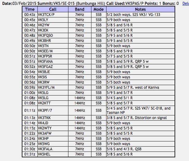
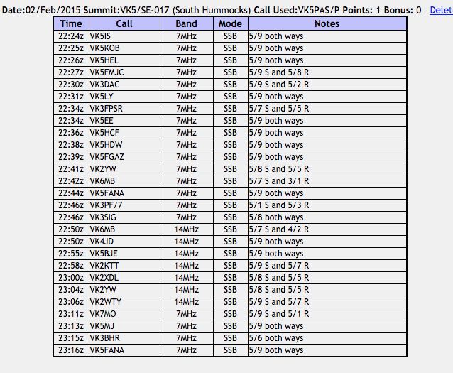
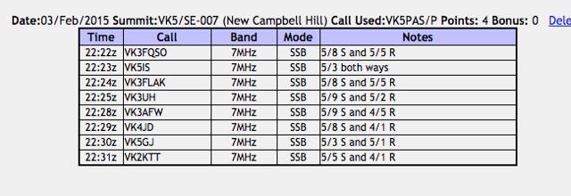
Anyway I pressed on and called CQ on 7.090. My first contact was with Amanda VK3FQSO (5/8 sent and 5/5 received), followed by Ian VK5IS (5/3 both ways), Bob Vk5FLAK (5/8 sent and 5/5 received), and my fourth and qualifying contact was with VK3UH (5/9 sent and 5/2 received).
Much to my surprise I was called by VK4JD who have me a 4/1 signal report, and Paul VK2KTT who also gave me a 4/1 signal report.
So felling very frustrated, I packed the gear up and headed down the hill back to the car. Just 8 contacts in the log, but thankfully the summit had been qualified.
I think the next time I active this summit I will try parking near Curnows Hut and walking north along the Heysen Trail to the summit. Easier? I’m not sure. At the current time this section of the forest is closed due to restoration work after the 2013 bushfire.
After the activation I headed in to Jamestown, where I went to the Jamestown bakery for a pastie. Jamestown is a beautiful little town and certainly worth a look. There is an interpretice centre for RM Williams, who was an Australian bushman and entrepreneur who rose from a swagman, to a millionaire. Fore more information on RM Williams, please have a look at the following…..
http://en.wikipedia.org/wiki/R._M._Williams
For more information on Jamestown, have a look at the following…..
http://www.visitjamestown.com.au/
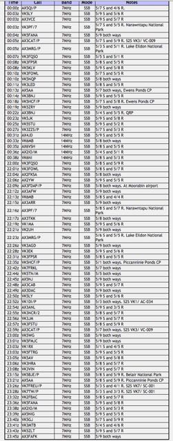
The following stations were worked:-
References.
ABC, 2015, <http://www.abc.net.au/news/2013-05-14/charred-bundaleer-forest/4687770>, viewed 8th February 2015.
Government of South Australia, Forestry SA, 2015, Bundaleer Visitor Information brochure, <https://www.forestry.sa.gov.au/Portals/0/Publications/InfoLeaflets/Bundaleer%20Forest.pdf>, viewed 8th February 2015
Government of South Australia, State Libarary, 2015, <http://www.samemory.sa.gov.au/site/page.cfm?u=77&c=5232>, viewed 8th February 2015
Munday; B, 2012, ‘those dry-stone walls’, Wakefield Press.