Lathami Conservation Park 5CP-114 and VKFF-0903

My fourth and final park activation for Tuesday 23rd August 2016 was the Lathami Conservation Park 5CP-114 and VKFF-0903.  This was to be another unique park for me.

Screen Shot 2016-08-15 at 9.57.07 PM

Above:- Map showing the location of the Lathami Conservation Park on the northern side of Kangaroo Island.  Image courtesy of Protected Planet.

After activating the Beyeria Conservation Park I headed back into the little village of Cygnet River and detoured out along Duck Lagoon Road.  Why?  Well one of the people I spoke to earlier in the day at the Cygnet Estuary Conservation Park, suggested I might want to have a look at Duck Lagoon and thought that it was part of the Cygnet Estuary Conservation Park.  As it has it, Duck Lagoon is not part of the park.  But I’m very pleased that I took the time to go out there for a look.

Duck Lagoon Road crosses the Cygnet River, and after all the recent rain on Kangaroo Island, the road almost resembled a river itself.  Certainly not passable in a conventional vehicle.

DSC_2266.jpg

Its just a short drive out along Duck Lagoon Road until you reach the lagoon itself.  There are camping facilities here and lots of interpretive signs.  As you would expect it was alive with bird life.  There is a bird hide at the lagoon where you can observe the various birdlife on the lagoon.

Duck Lagoon was quite different in appearance prior to the 1960’s, to what it is today.  The area was covered in Bullrushes and Water weeds and was teaming with birdlife including ducks, moor hens, coot, egrets, herons, kingfishers, finches and wrens.  Sadly the lagoon became affected by increasing salinity due to land clearance and this resulted in the degradation of the plant life and thus the birds.  During the 1990’s the entire area was the subject of a re-vegetation process undertaken by 15 local trainees who were enrolled in a 6 month Youth Conservation Corps project.

You can also view some historic ruins and an old eucalyptus still.  Arthur Weatherspoon (1882-1942), his wife, and their six children lived here in the early 1900’s.  Arthur built the old house and sheds that you can find and also established the eucalyptus still.  He strained his heart trying to put a beam on the roof of the log shed and was told by his doctor never to work again.  However whilst harvesting in the paddock with his horses, he suffered his first heart attack.  At age 60, he had another heart attack whilst crutching sheep in the shearing shed, and died as a result.  It is certainly very interesting walking around here.

I then headed off to Lathami, which is just one km up the road from my accomodation at Stokes Bay, and around 17 km north of Parndana.   The Lathami Conservation Park was proclaimed on the 1st October 1987 and comprises 1,175 hectares (2,900 acres).  The park’s name related to the scientific name for the Glossy Black Cockatoo (Calyptorhynchus lathami halmaturinis).

The park provides a foraging and breeding habitat for this subspecies of Glossy Black Cockatoo, which is an endangered species in South Australia.  About 250 of these birds remain.  Once found as far north as Adelaide, these birds are now mostly confined to Kangaroo Island, with some occasional sightings on the Fleurieu Peninsula.  The main predator of the Glossy Black is the Brush Tail possum which has been found to take the single egg or chick from many nests.

A local KI initiative to save the Glossy Black Cockatoo is ongoing, with various nesting boxes being established and replanting of the Drooping Sheaok feeding habitat.

1280px-Glossy_Black_Cockatoo_(Calyptorhynchus_lathami)

Above:- Glossy Black Cockatoo.  Courtesy of Wikipedia.

In the higher portions of the park, tall shrubland exists, dominated by Brown Stringybark, Tates Grass-tree, Broombush, Slaty Sheoak, and Sugar Gum.  In the lower section of the park, an open forest is found with is dominated by Sugar Gum and South Australian Blue Gum.  The northern area of the park includes the Deep Gully Creek.

The park was expanded in 1985, when around 1,200 ha were purchased and added to the park.  During the latter half of the 19th century, a large amount of timber was cut from this are for use in the copper mines at Moonta.  This was mostly South Australian Blue Gum and Sugar Gum.  A number of aboriginal artefacts have been located in the park and in the Stokes Bay area generally.

I set up in the carpark of Lathami, using the park sign to secure the squid pole.  I was all ready to go by around 5.55 p.m. South Australian local time (0825 UTC).

Screen Shot 2016-09-04 at 8.08.20 PM.jpg

Above:- Aerial shot showing the Lathami Conservation Park, and my operating spot, and also my accomodation at Stokes Bay.  Image courtesy of Protected Planet.

As is my custom, I started off on 40m, with the first station logged being park stalwart, Mike VK6MB who was an excellent 5/9 signal.  This was followed by some more of the park die hards in the form of Peter VK3PF and Rick VK4RF.  I worked a total of 22 stations on 40m from VK2, VK3, VK4, VK6, and VK7.  Almost all signals were 5/9 in signal strength.  My last contact on 40m was with Roald VK1MTS who was running just 2 watts from a home brew double sideband transceiver.  Roald started off as a good 5/4 and gave me a 5/7.  But a few minutes into our QSO, we totally dropped out to each other.  It was time for 80m.

DSC_2287

I then lowered the squid pole and inserted the links and headed off to 80m in the hope that I might be able to work some of the local VK5’s, as there was no close in propagation on 40m.  I called CQ on 3.610 and this was answered by Mick VK3GGG/VK3PMG in western Victoria with a very strong 5/9 signal.  This was followed by Rick VK4RF/VK4HA who was also 5/9.  The 80m band was in great shape.  A further 21 stations gave me a shout, from VK1, VK2, VK3, VK4, and VK5.  My last contact from Lathami was with the Battle of Long Tan special event call of VI1BLT50, with Tex VK1TX at the mic.

It was getting pretty chilly and I was hungry.  The local time in SA was now approaching 7.30 p.m.  I had a total of 48 contacts in the log and another unique park in the log.

DSC_2290

The following stations were worked on 40m SSB:-

  1. VK6MB
  2. VK3PF
  3. VK4RF
  4. VK4HA
  5. VK4ME
  6. VK3FSPG
  7. VK2IO
  8. VK6NU
  9. VK3BL
  10. VK2SI/p
  11. VK2HHA
  12. VK7FPRN
  13. VK4FFAB
  14. VK6JES
  15. VK2NP
  16. VK3MRH
  17. VK2LAD
  18. VK2FSAV
  19. VK2NWB
  20. VK7BC
  21. VK2ZWZ
  22. VK1MTS

The following stations were worked on 80m SSB:-

  1. VK3GGG
  2. VK3PMG
  3. VK4RF
  4. VK4HA
  5. VK3SQ
  6. VK2NP
  7. VK5FMID
  8. VK5FVSV
  9. VK2GPT
  10. VK2LDN
  11. VK3BBB
  12. VK4AAC/3
  13. VK5FANA
  14. VK3MCK
  15. VK5FMLO
  16. VK4FPAT
  17. VK5PL
  18. VK3ELH
  19. VK5KLV
  20. VK1MTS
  21. VK2VOO
  22. VK3UH
  23. VK3HSB
  24. VK2NN
  25. VK5ATQ
  26. VI1BLT50

Thanks to everyone who spotted me, including Mike VK6MB.


References.

Kangaroo-island.com, <http://www.kangaroo-island-au.com/attractions/duck_lagoon/dl_introduction.html&gt;, viewed 5th September 2016

Kangaroo-island.com, <http://www.kangaroo-island-au.com/attractions/duck_lagoon/dl_introduction.html>, viewed 5th September 2016

National Parks and Wildlife Service, 1992, Beyeria and Lathami Conservation Parks Management Plan

Beyeria Conservation Park 5CP-017 and VKFF-1005

My third park activation for Tuesday 23rd August 2016 was the Beyeria Conservation Park 5CP-017 and VKFF-1005.  This was to be another unique park for me, for both the World Wide Flora Fauna (WWFF) program and the VK5 National & Conservation Parks Award.

Screen Shot 2016-08-15 at 9.53.54 PM.jpg

Above:- Map showing the location of the Beyeria Conservation Park on Kangaroo Island.  Image courtesy of Protected Planet.

The Beyeria Conservation Park was established on 14th May 1987, and comprised 188 hectares (460 acres).  The park is located about 16 kilometres south of Kingscote on the northern edge of the MacGillivray Plain.  It was proclaimed a conservation park following requests to the state government by conservation groups and botanists to prevent further land clearing for agriculture in the vicinity, as well as to protect populations of rare plant species. The name of the conservation park is taken from the generic name of one of the plants so protected – the Kangaroo Island Turpentine Bush (Beyeria subtecta).

More information on Beyeria subteca can be found at……

http://saseedbank.com.au/species_information.php?rid=675

DSC_2182.jpg

Prior to its acquisition, the park saw repeated burning and clearing, particularly in the northern section.

The park contains  a small, seasonally-filled swamp in the south-eastern corner.  The vegetation in the park consists of Eucalyptus cneorifolia woodland with Melaleuca uncinata, and Callistemon rugulosus in the swampy area.  Apart from the turpentine bush, rare endemic plants in the reserve include Grevillea muricata, Olearia microdisca and Caladenia ovata.  The park was alive in flower during my visit.

There was no issue in finding Beyeria.  It is well signposted off Willsons Road and clearly has had financial contributions, as there are visitor signs and a nice parking area out the front of the park.

John VK5BJE activated this park back in May 2014.  Here is a link to his post on his WordPress site…..

Beyeria Conservation Park, Kangaroo Island, 12 May 2014

I set up the fold up table and deck chair in the carpark and used a permapine post to secure the squid pole with the assistance of a few octopus straps.  After setting up I headed to 7.144 and asked if the frequency was in use.  I didn’t even get the chance to call CQ.  A pile of hungry park activators were there waiting for me.  First cab off the rank was Dennis VK2HHA, followed by Tom VK5EE, Col VK5HCF and then Geoff VK3SGQ.  All the usual suspects followed, with terrific signals coming into Beyeria from VK2, VK3, VK4, VK5, VK6, and VK7.

Screen Shot 2016-09-04 at 7.24.04 PM.jpg

Above:- Aerial shot showing my operating spot in the Beyeria Conservation Park.  Image courtesy of Protected Planet.

I was 19 QSOs into the activation, and chatting to Greg VK5GJ who was running QRP 4 watts, when the heavens started to open up.  So it was a quick scramble to the 4WD to grab the bothy bag.  Fortunately my time under the bothy bag was limited to around 5 minutes, and the showers cleared.

Soon after I started to experience a little bit of QRM from 7.145.  I went up 1kc and kindly asked the VK2 guys if they would mind QSYing and they obliging did so.

This particular activation was a good one for acquiring a few more Park to Park (P2P) contacts.  The first was with Neil VK4HNS/2 who was in the Koreelah National Park VKFF-0268 (5/8 sent and 5/7 received).  Next was Phil VK6ADF/p in the Hassell National Park VKFF-0228, a distance of around 2,500 km (5/5 sent and 5/6 received).  But the icing in the cake was yet to come.

After working a total of 50 stations on 40m I lowered the squid pole and removed the links and then headed to 14.310 on 20m.  First taker there was Rick VK4RF.  Wow, has Rick got dedication.  He features in virtually all of my park activations that I’ve conducted in recent times.  Steve VK4KUS then called in to say g’day from Hervey Bay, followed by Cliff VK2NP.  The DX then started to roll in.  First up was DK0EE in Germany, followed by Oliver DK7TX in Dusseldorf, Germany.  I worked a total of 21 stations on 20m, but the highlight was working my very good friend Marnix OP7M (who I stayed with whilst in Europe), and also two European P2P contacts.

The first was with my good mate Danny OT4V/p who was portable in Vallei van de Helderbeek ONFF-0296.  Danny was quite weak (3/3) but we made it, with Danny giving me a 4/4 signal report from his park in Belgium.


ot4v_onff0296.jpg

Danny OT4V has a nice WordPress site of all his park activations which can be found at…..

http://www.on4vt.be/

This was followed by a P2P contact with Swa ON5SWA who was portable in Wolvertemse Beemden ONFF-0499.  Swa was a little stronger than Danny (5/3) and Swa gave me a 4/4 from his park in Belgium.

So after nearly 90 minutes in the park I had a total of 71 contacts in the log on 20m and 40m, and two memorable P2P contacts into Belgium.

The following stations were worked:-

  1. VK2HHA
  2. VK5EE
  3. VK5HCF
  4. VK3SQ
  5. VK4RF
  6. VK4HA
  7. VK3BBB/m
  8. VK3TKK/m
  9. VK5MRT
  10. VK5BJE
  11. VK3GGG
  12. VK3PMG
  13. VK5KLV
  14. VK2KYO
  15. VK3PF
  16. VK3MRH
  17. VK5FANA
  18. VK5FMJC
  19. VK5GJ
  20. VK3ZMD
  21. VK2MOR/m
  22. VK5ZK
  23. VK3UH
  24. VK2IO
  25. VK7DIK
  26. VK5FMID
  27. VK5FMLO
  28. VK2NP
  29. VK5APV
  30. VK4FFAB
  31. VK3HSB
  32. VK5KKT
  33. VK2MTC
  34. VK6MB
  35. VK4JK
  36. VK2PDW/m
  37. VK4HNS/2 (Koreelah National Park VKFF-0268)
  38. VK5GI
  39. VK5IS
  40. VK5JK
  41. VK5ZZ/m
  42. VK3FRAB
  43. VK5ZGY/m
  44. VK3MCK
  45. VK3ZZS/4
  46. VK3SFG
  47. VK5GJ/p
  48. VK3ADM/4
  49. VK6ADF/p (Hassell National Park VKFF-0228)
  50. VK5VRB

The following stations were worked on 20m SSB:-

  1. VK4RF
  2. VK4HA
  3. VK4KUS
  4. VK2NP
  5. DK0EE
  6. DK7TX
  7. VK6DW/m
  8. VK3NCC/4
  9. VK6MB
  10. ON4CB
  11. ON8BE
  12. OH6IU
  13. ON3ANY
  14. DL1EBR
  15. OT4V/p (Vallei van de Helderbeek ONFF-0296)
  16. F1BLL
  17. OP7M
  18. IK2ZJN
  19. IK8FIQ
  20. ON4ON
  21. ON5SWA/p (Wolvertemse Beemden ONFF-0499).

Thanks to everyone who spotted me, including Rob VK4FFAB.

At the end of the activation I went for a walk around the loop circuit in the park.  It’s well worth doing and gives you a good appreciation of the park.


References.

National Parks and Wildlife Service, 1992, Beyeria and Lathami Conservation Parks Management Plan.

Wikipedia, 2016, <https://en.wikipedia.org/wiki/Beyeria_Conservation_Park&gt;, viewed 5th September 2016

Nepean Bay Conservation Park 5CP-159 and VKFF-1067

I was already running behind schedule for my second park of the day and it wasn’t going to get any better.  Access to the Nepean Bay Conservation Park 5CP-159 and VKFF-1067 proved a little trickier than originally planned.  So if I sounded a little flustered or grumpy during this action, you’re about to read why.

Screen Shot 2016-08-15 at 9.50.02 PM

Above:- Map showing the location of the Nepean Bay Conservation Park on Kangaroo Island.  Image courtesy of Protected Planet.

After leaving Cygnet Estuary with wet feet I headed south east along the Hog Bay Road and into the little settlement of Nepean Bay.  My plans were to travel along Sea Vista Road.  But what appeared on the maps as a road, is little more than a very neglected 4WD track.  And many sections were impassable (see below).  So this park required a bit of walking and carrying of gear to get into as well.

DSC_2175

The only pleasing thing was that the view of Nepean Bay was truly beautiful.  And the weather on Kangaroo Island, despite it being August, was mild and slightly overcast, with plenty of blue sky.

Nepean Bay was named by Captain Matthew Flinders (1774-1814) on 21st March 1802 after Sir Evan Nepean.  Sir Evan was a British politician and colonial administrator.

Above:- Captain Matthew Flinders (left) and Sir Evan Nepean (right.  Images courtesy of Wikipedia.

Nepean Bay Conservation Park comprises 32 hectares (79 acres) and was proclaimed on 11th July 1974.  It was dedicated for the protection of flora and fauna, and is the only reserved area of coastal sandplain on Kangaroo Island.  The park lies on the southern shoreline of Western Cove in Nepean Bay, about 1.5 kilometres to the east of the Nepean Bay settlement, and about 9 km south of Kingscote.

The park’s vegetation is mostly an open scrub of Eucalyptus diversifolia and Callitris preissii with areas of low shrubland, tussock sedgeland and Allocasuarina verticillata low open forest.  Other significant plant species include Melaleuca halmaturorum, Acacia sophorae and Leucopogon parviflorus.  There is a nesting colony of fairy terns on the coast adjacent to the  park and Tammar wallabies are common, as I found.


I set up in a clearing amongst the scrub and was all set and ready to go by 1.00 p.m. SA local time (a long way behind schedule).  My first contact on 40m was with Geoff VK3SQ, followed by Mick VK3GGG, and then Jonathan VK6JON/7.

Screen Shot 2016-09-04 at 6.58.01 PM

Above:- Aerial shot showing the Nepean Bay Conservation Park, about 1.5 km east of the Nepean Bay settlement.  Image courtesy of Protected Planet.

It was very pleasing to see the 40m band open locally with a number of South Australian stations logged including Tom VK5EE, Col VK5HCF, Brian VK5FMID, John VK5DJ & Greg VK5ZGY mobile all in the South East, John VK5EMI in the Adelaide Hills, Adrian VK5FANA & Bevan VK5APV on the Yorke Peninsula, Michael VK5FMLO in the southern suburbs of Adelaide, David VK5PL in the Barossa Valley, Les VK5KLV at Port Augusta, Jeff VK5JK at Victor Harbour and Gary VK5ZK at Goolwa south of Adelaide.  All from very diverse locations around the State, and all with great signals.  This certainly has not been the case in recent months, with close in propagation on 40m at times being non existant.

DSC_2174.jpg

The little guy (or girl?) below, a Tammar wallaby, kept a close on me for around 15 minutes of my activation.  I was very surprised.  I thought that with the noise associated with setting up, and talking on the radio, he/she would have scampered off into the scrub.  But no, they hung around for quite some time watching proceedings.

DSC_2173

I worked a total of 29 stations on 40m.  Contact number 44 was Cliff VK2NP, and this was 40 minutes into the activation.  A total of 44 QSOs are required to qualify the park for the global section of the World Wide Flora Fauna (WWFF) program.  Here in Australia, park activators and hunters tend to talk a lot more and exchange information, compared to European park activators where it is pretty much ‘5/9 thanks…..73 and 44’, and then on to the next contact.  So to qualify the park in just 40 minutes was very pleasing, especially considering I was behind schedule and had 2 parks to activate that day.

I managed to accrue a further two Park to Park (P2P) contacts from Nepean Bay.  They were with VK4AAC/3 in the Point Addis Marine National Park VKFF-0952 on the Great Ocean Road, and Neil VK4HNS/p who was in the Koreelah National Park VKFF-0268.  I activated Point Addis myself back in November 2015 and have a clear memory of the activation as the Paramedics were called during the activation, as somebody (not me) had fallen down a nearby cliff face.  For more information on that activation, please have a look at……

https://vk5pas.org/2015/12/10/point-addis-marine-national-park-vkff-0952/

After things slowed down on 40m I headed over to 20m where I worked Cliff Vk2NP, WIlliam VK2NWB, Mike VK6MB, and Colin VK3NCC/4.   It was still a little too early for any DX on 20m.  I did not bother trying 80m during this activation due to time constraints and also because 40m was open to VK5.

Another successful activation, with a total of 54 contacts in the log.  And again many thanks to those who posted me, including Jonathan VK6JON.  It certainly does help fill up the logbook.

The following stations were worked on 40m SSB:-

  1. VK3SQ
  2. VK3GGG
  3. VK3PMG
  4. VK6JON/7
  5. VK2PDW
  6. VK3BBB
  7. VK3UH
  8. VK3MRH
  9. VK3MCK
  10. VK3TKK
  11. VK5EE
  12. VK2IO
  13. VK5HCF
  14. VK3NXT
  15. VK5EMI
  16. VK2HHA
  17. VK5ZGY/m
  18. VK5FANA
  19. VK5FMLO
  20. VK2NWB
  21. VK4RF
  22. VK4HA
  23. VK3PAT
  24. VK5GJ
  25. VK4AAC/3 (Point Addis Marine National Park VKFF-0952)
  26. VK4ARW
  27. VK5ZK
  28. VK4HNS/p (Koreelah National Park VKFF-0952)
  29. VK4RZ
  30. VK3FINE
  31. VK5FMID
  32. VK5DJ
  33. VK5JK
  34. VK5PL
  35. VK5HS/2
  36. Vk5FLEX/2
  37. VK2KYO
  38. VK5KLV
  39. VK2JAZ
  40. VK3SFG
  41. VK3FRAB
  42. VK5ZGG
  43. VK6MB
  44. VK2NP
  45. VK3FARO
  46. VK5APV
  47. VK3FABE
  48. VK2FMJW
  49. VK7CW
  50. VK3NCC/4

The following stations were worked on 20m SSB:-

  1. VK2NP
  2. VK2NWB
  3. VK6MB
  4. VK3NCC/4


References.

Wikipedia, 2016, <https://en.wikipedia.org/wiki/Nepean_Bay_Conservation_Park&gt;, viewed 17th August 2016

Cygnet Estuary Conservation Park 5CP-273 and VKFF-1130

My first planned park activation for Tuesday 23rd August 206 was the Cygnet Estuary Conservation Park 5CP-273 and VKFF-1130.  This was to be the first of four scheduled park activations for Tuesday, and all unique parks towards my activator tally for both the VK5 National & Conservation Parks Award, and the World Wide Flora Fauna (WWFF) program.

Screen Shot 2016-08-15 at 9.46.15 PM.jpg

Above:- Map showing the location of the Cygnet Estuary Conservation Park on Kangaroo Island.  Map courtesy of Protected Planet.

I had a bit of a sleep in on Tuesday morning, rising from my slumber at around 8.00 a.m. SA local time.  The coffee pot was the first point of call for the morning, followed by breakfast on the porch of the cabin.  As I had arrived at Waves & Wildlife on Monday night whilst it was dark, this was the first opportunity I had to see my surrounds during daylight.  The cabins are set on the top of a hill on acreage overlooking Stokes Bay.

There were a large number of Western grey kangaroos grazing in front of the cabins and also enjoying the beautiful morning sunlight.  I suspect waiting for a possible breakfast from some of the tourists.  Alongside of my cabin a number of Crimson Rosellas were also busy feeding on the seeds from some of the native plants.

After breakfast I headed down to Stokes Bay itself where I sat for a while enjoying the morning and taking a few photographs of the plethora of seabirds.  It is believed that Stokes Bay was named after the first mate of the Hartley which arrived in South Australia in October 1837.

I then commenced heading south on the Stokes Bay Road towards Parndana.  There were some nice views of Stokes Bay in the rear vision mirror as I reached the high point of the road.  A short photo stopped ensued.

DSC_2121.jpg

Mobile telephone reception on Kangaroo Island, depending on your carrier, can be very patchy.  And that’s certainly what I experienced with Optus.  There was no mobile phone reception at Stokes Bay, so once I got to Parndana, I stopped to view the best route into the Cygnet Estuary Conservation Park.  It appeared that I might be able to get into the park via Estuary Road, off the Playford Highway, but I was wrong.  I drove down a dirt track off Estuary Road but reached a sign saying no entry.  So it was back to Playford Highway and a review of the map on the phone.

There appeared to be a track running off Hog Bay Road, so I travelled back in that direction, but sadly that was a no go as well.  So it was back into Bronwlow for me and with the assistance of some of the friendly locals, I drove along the beach at Brownlow.

DSC_2145

I reached a point where I couldn’t go any further so it was out on foot for the rest of the way.

DSC_2163

As I was near the mouth of the Cygnet, the area was alive with birdlife, including Pied Oystercatchers, pelicans, cormorants, and Black swans.

Cygnet Estuary Conservation Park is located on the west coast of Nepean Bay on Kangaroo Island, about 5 kilometres west southwest of Kingscote.  It was proclaimed under the National Parks and Wildlife Act 1972 in 2014 on the basis that some existing crown land ‘should be protected and preserved for the purpose of conserving any wildlife and the natural features of the land’.  The Cygnet Estuary which is considered to be a significant wetland is located within the boundaries of the conservation park.

The Cygnet River took its name from the Cygnet, which was the second ship to arrive in the colony of South Australia.  She sailed from England under the command of Captain John Rolls, and arrived in Nepean Bay on Kangaroo Island on 11th September 1836.  The Cygnet which had been built of teak in India in 1827 had been chartered by the Colonisation Commissioners to sail for South Australia in 1836, carrying many or the survey staff, along with a number of emigrants.

Screen Shot 2016-09-04 at 5.39.23 PM

Above:- Sketch of the Cygnet at anchorage at Port Augusta, 1833.  Image courtesy of State Libarary of Western Australia.

However the river has not always been known as the Cygnet.  It was originally known as the Three Wells River, and also the Morgan River after Captain R.G. Morgan of the Duke of York, the first vessel to bring immigrants.  The first reference of the Cygnet (or Three Wells River) can be found in a letter which Colon William Light wrote to the Colonial Storekeeper on 6th September 1836, in which Light recommended him to land stores on Kangaroo Island from the Cygnet at the mouth of the freshwater river.

After some negotiation of the estuary, and a few trips back to the 4WD, I found an operating spot.  This definitely wellington boots territory!  I ran the Yaesu FT-857d, 40 watts and the 20/40/80m linked dipole for this activation.

Screen Shot 2016-09-04 at 11.11.57 AM.jpg

Above:- Aerial shot showing my operating spot.  Courtesy of Protected Planet

I was set up and ready to go a little later than planned, just after 10.00 a.m. South Australian local time.  I was very pleased to have Rob VK4AAC/3 as number one in the log at Cygnet Estuary.  Rob was portable in the Great Otway National Park VKFF-0405 and had a beautiful 5/9 signal.  Not a bad way to start the activation….a Park to Park (P2P).  The frustration of getting lost and the backwards and forwards travel to get into the park, was tethered a little by the P2P contact with Rob.  This was followed by the ever reliable Mick VK3GGG/VK3PMG, Peter VK3TKK, and then Peter VK3PF.

DSC_2141

The 40m band was behaving itself, with some great signals from VK2, VK3, VK4, VK5, VK6 and VK7.  A number of mobile stations were logged including Greg VK5ZGY mobile in the South East, Peter VK5FLEX/2 and VK5HS/2 at Byrock in New South Wales, and John VK2YW mobile near Hay.  Jarrad VK6FFAR/p who was alongside the ocean running his 10 watts was a very nice 5/5 signal to Cygnet River.

I was pleasantly surprised at how well the Western Australian stations were coming in on 40m considering the time of the day.  Mike VK6MB was a good 5/7 (5/5 received), whilst Don VK6EY at Busselton in the South West was a strong 5/8 (5/8 received).

DSC_2150

Neil VK4HNS portable in the Koreelah National Park VKFF-0268 called in and was a 5/3 signal at Cygnet Estuary (5/3 received).  Another P2P contact for the log.

After working a total of 48 stations on 40m I headed over to 14.310 on 80m where I worked Rick VK4RF/VK4HA, John VK5EMI, Mike VK6MB and Brooke VK4RZ.  I was very surprised to work John VK5EMI on 20m.  John lives in the Adelaide Hills and although not strong, was very readable in Cygnet Estuary (5/2 sent and 4/3 received).  I would have loved to try 80m, but it was a bit tricky with the length of the antenna, and my feet were already sopping wet, and I was way behind schedule.  So it was time to pack up, with a total of 53 contacts in the log.

DSC_2156

The following stations were worked on 40m SSB:-

  1. VK4AAC/3 (Great Otway National Park VKFF-0405)
  2. VK3GGG
  3. VK3PMG
  4. VK3TKK
  5. VK3PF
  6. VK3BBB
  7. VK2IO
  8. VK2KYO
  9. VK6FFAR/p
  10. VK2NP
  11. VK3PAT
  12. VK5HCF
  13. VK5EE
  14. VK5ZGY/m
  15. VK3SQ
  16. VK3SFG
  17. VK4RF
  18. VK4HA
  19. VK6MB
  20. VK5FVSV
  21. VK5FANA
  22. VK2XXM
  23. VK5PL
  24. VK3MCK
  25. VK5MRT
  26. VK5FLEX/2
  27. VK5HS/2
  28. VK5KLV
  29. VK3NXT
  30. VK2YW/m
  31. VK2NWB
  32. VK4FFAB
  33. VK4NBX
  34. VK3MRH
  35. VK6ET
  36. VK3ANP
  37. VK4HNS/p (Koreelah National Park VKFF-0268)
  38. VK4RZ
  39. VK3CM
  40. VK5EMI
  41. VK5FMID
  42. VK5DJ
  43. VK2HHA
  44. VK2MOR
  45. VK7WN
  46. VK7FPRN
  47. VK5BJE
  48. VK3UH

The following stations were worked on 20m SSB:-

  1. VK4RF
  2. VK4HA
  3. VK5EMI
  4. VK6MB
  5. VK4RZ

Again, thanks to all those that took the time to spot me, including Gerard VK2IO.


References.

Bound for South Australia, 206, <http://boundforsouthaustralia.com.au/journey-content/cygnet.html&gt;, viewed 5th September 2016.

Cockburn; R, 2002, South Australia Whats in a name?,

Wikipedia, 2016, <https://en.wikipedia.org/wiki/Cygnet_Estuary_Conservation_Park&gt;, viewed 17th August 2016

Parndana Conservation Park 5CP-171 and VKFF-0925

My final park for Monday 22nd August 2016 on Kangaroo Island was the Parndana Conservation Park 5CP-171 and VKFF-0925.  The park is around 73 km (1 hour drive) from the Dudley Conservation Park, and about 30 km from my accomodation for the night at Stokes Bay.

Screen Shot 2016-08-15 at 9.42.10 PM

Above:- Map showing the location of the Parndana Conservation Park on Kangaroo Island.  Image courtesy of Protected Planet.

After leaving Dudley I headed into the little settlement of Baudin Beach.  It was named to honour the French navigator, Nicolas Baudin and his exploration of Kangaroo Island way back in 1802.   I stopped to have a look at the Baudin monument and also admire the view of Nepean Bay.

I then headed west along Hog Bay Road, stopping briefly to admire Pelican Lagoon and the adjacent Prospect Hill.  I had plans to activate Pelican Lagoon Conservation Park on Wednesday.  The explorer Matthew Flinders named Prospect Hill on 4th April 1802 and also named Pelican Lagoon, on account of the large number of pelicans sighted.

I continued along Hog Bay Road and then onto the Playford Highway.  There were numerous canola crops in flower, with their yellow flower making a great contrast to the now rather grey and bleak skies.

DSC_2045

After a number of km along the Playford Highway, I turned off onto Yacca Jacks Road.  Only in Australia could you have a road named like that!  The park was named after a local, Jack Charles ‘Yacca Jack’ Austin.  I soon found the south western corner of the park.  There was a track here (Stringybark Track) following the southern boundary of the park, but the gate to the track was well and truly locked.

DSC_2046

I continued along Yacca Jacks Road, dodging the fallen trees and the rather boggy patches on the road.  There had been a lot of rain and strong winds so there was quite a bit of water and debris on the road.

DSC_2047

I soon came to the northern boundary of the park and Boundary Track which was accessible.  I set up in amongst the scrub on the northern side of the park.

Screen Shot 2016-09-04 at 10.46.43 AM

Above:- Aerial shot showing the location of the park and my operating spot, and the nearby town of Parndana.  Image courtesy of Protected Planet.

Parndana Conservation Park is 625 hectares (1,540 acres) n size and was established on the 1st January 1968 for the protection of remnant native vegetation.  The park is located in the locality of Cassini about 7 kilometres north-east of the town of Parndana in the central part of the island, about 30 kilometres west of Kingscote.

The name Parndana means ‘The place of the little gums’.  The nearby town of Parndana was established after World War Two to support the Soldier Settlement Scheme on Kangaroo Island.

Most of the park carries low open forest and shrubland featuring Eucalyptus baxteri and E. cosmophylla over Allocasuarina muelleriana, Banksia marginata, B. ornata, Xanthorrhoea tateana, Leptospermum myrsinoides and Hakea sp. The park provides feeding and nesting habitat for Glossy Black Cockatoos.

As is normal for me for my park activations I started off on 40m first on 7.144.  First taker for Parndana was the ever reliable Rick VK4RF/VK4HA, followed by Ken VK2KYO and then Geoff VK3SQ.  My fourth contact was a Park to Park (P2P) contact with Rob VK4AAC/3 who was in the Port Phillip Heads Marine Park VKFF-0954.  I was cognisant of the time.  It was marching on to being after 4.30 p.m. SA local time (0700 UTC), and I wanted t0 try 20m from this park, so after working a total of 15 stations I headed for 14.310 on 20m.

My first caller there was Mike VK6MB, followed by David VK4ABH.  And then a little run of DX commenced, with Enzo IU8ACV from Italy being the first caller.  I went on to work a total of 23 stations on 20m from VK4, VK6, Italy, Slovenia, Belgium, France, Spain, and Japan.

When things slowed down I moved back to 7.144 where I worked another 13 stations from VK1, VK2, VK3, VK4, VK6, and VK7.  This included a Park to Park contact with Neil VK4HNS who was portable in the Bald Rock National Park VKFF-0011.  This was my second P2P contact for Parndana.  I started to get hammered by a K1 station from the USA on 7.142 so I decided it was time to try 80m before packing up and heading off to my accomodation at Stokes Bay.

The sun was setting and it was quite enjoyable sitting back in the deck chair admiring the view.  On 80m I was very pleased to log a total of 9 stations from VK2, VK3, VK5, and VK7.  The VK5’s included Adrian VK5FANA, John VK5BJE, Nev VK5WG, and Phil VK5RM.  Propagation locally was not working on 40m, and 80m proved very reliable with 5/9 plus signals around the State.  I was also pleased to speak with Alvin VK7FLI on Flinders Island, OC-195 for the Islands on the Air (IOTA) program.

DSC_2057

After logging a total of 60 stations on 20, 40, and 80m,  it was time to pack up and make the 30km journey down the road to Stokes Bay.  It was now almost dark, being nearly 6.00 p.m. SA local time, and I was cognisant it would be a slow trip due to the large number of kangaroos and wallabies.  Night time driving on Kangaroo Island can be a real challenge, as two thirds of the island are in their native state, so there is a lot of wildlife.

The following stations were worked on 40m SSB:-

  1. VK4RF
  2. VK4HA
  3. VK2KYO
  4. VK3SQ
  5. VK4AAC/3 (Port Phillip Heads Marine Park VKFF-0954)
  6. VK3BBB
  7. VK1DI
  8. VK5KLV
  9. VK2IO
  10. VK2NP
  11. VK3GGG
  12. VK3PMG
  13. VK6MB
  14. VK5BJE
  15. VK3FSPG
  16. VK3ELH
  17. VK2MZ
  18. VK2VOO
  19. VK6FAAD/m
  20. VK3PF
  21. VK4FFAB
  22. VK1HW
  23. VK4HNS/p (Bald Rock National Park VKFF-0011)
  24. VK3SIM
  25. VK6NU
  26. VK6JON/7
  27. VK3KRH
  28. VK3CM/p

The following stations were worked on 20m SSB:-

  1. VK6MB
  2. VK4ABH
  3. IU8ACV
  4. IZ8EFD
  5. IK2ZJN
  6. S50A
  7. ON4ON
  8. F1BLL
  9. EA7TR
  10. I1HYW
  11. IW5DOK
  12. I5JRR
  13. EA4DTV
  14. I0SYQ
  15. IK8FIQ
  16. I5JRR
  17. EA3MP
  18. IV3YIB
  19. EA4MY
  20. F4FEP
  21. I5FLN
  22. JH3GFA
  23. IK2RZQ

The following stations were worked on 80m SSB:-

  1. VK5FANA
  2. VK5BJE
  3. VK3GGG
  4. VK3PMG
  5. VK2SK
  6. VK3KRH
  7. VK5WG
  8. VK5RM
  9. VK7FLI (Flinders Island OC-195)

Thanks to everyone who took the time to spot me, including Mike VK6MB.

I pulled in to my accomodation for the next 2 nights, the Waves an Wildlife cottages at Stokes Bay.  The land surrounding the cabins was absolutely alive with Tamar wallabies.

I can highly recommend Waves & Wildlife.  There is a choice of 1 and 3 bedroom cottages. Each contains a kitchen, dining room, TV, DVD, CD, and all of your kitchen utensils.

Whilst cooking tea, which consisted of a typical bachelors evening meal of sausages, patties and salad, I booked in to the 7.130 DX Net.  I had set up the Yaesu FT-450 and the linked dipole.  I worked a total of 14 stations on the net from VK2, VK4, VK7, French Polynesia, USA, and New Zealand.  It was then off to bed, with a planned four park activations for Tuesday.


References.

Wikipedia, 2016, <https://en.wikipedia.org/wiki/Parndana_Conservation_Park&gt;, viewed 17th August 2016

Wikipedia, 2016, <https://en.wikipedia.org/wiki/Parndana,_South_Australia&gt;, viewed 4th September 2016

Dudley Conservation Park 5CP-058 and VKFF-0809

My second park for the day (Monday 22nd August 2016) was the Dudley Conservation Park 5CP-058 and VKFF-0809, which is about 30 minute drive from the Simpson Conservation Park.

Screen Shot 2016-08-15 at 9.37.02 PM.jpg

Above:- Map showing the location of the Dudley Conservation Park on the Dudley Peninsula, Kangaroo Island.  Image courtesy of Location SA Map Viewer.

Dudley Conservation Park was established on the 1st January 1970 and is 1,768 hectares (4,370 acres) in size.  It was dedicated in 1970 to conserve Kangaroo Island Narrow-leaved Mallee.  The conservation park lies on the Dudley Peninsula on the eastern end of Kangaroo Island, about 10 km south-east of American River and 12 km south-west of Penneshaw.

DSC_2021

The Dudley Peninsula was originally known as Presquila Gallissoniere and also as the MacDonnell Peninsula from 1857 to 1986.  The first reported European name for the Dudley Peninsula is “Presquila Gallissoniere” which was given by the Baudin expedition.  In 1857 it was named  the “MacDonnell Peninsula” by William Bloomfield Douglas after Richard Graves MacDonnell, the sixth governor or South Australia.  In 1986, the peninsula was  renamed as the Dudley Peninsula.  The Hundred of Dudley had been proclaimed on 13th August 1874 by Governor Anthony Musgrave.  The hundred is reported as being named by Governor Musgrave after his father-in-law,  Sir David Dudley Field, who was an American jurist.  Musgrave had married Field’s daughter, Jeannie Lucinda Field.

Above:- Governor & Lady Musgrave.  Images courtesy of Bonzle and Wikipedia

The conservation park’s vegetation is mostly an open scrub of Eucalyptus diversifolia and E. rugosa, with E. cneorifolia, the Kangaroo Island Narrow-leaved Mallee for which the park was dedicated.

Sadly, the weather had turned, and the sunshine had disappeared and had been replaced by quite heavy showers.  I was hoping it was going to clear by the time I reached Dudley, but it hadn’t so I sat in the 4WD for a few minutes until the shower activity had cleared.  I turned off the Hog Bay Road and then travelled south along Sandhurst Road until I found a clearing in the scrub and this is where I set up.  Fortunately the blue sky made a welcome re-appearance.

Screen Shot 2016-09-03 at 9.43.21 PM

Above:- Aerial shot of the Dudley Conservation Park, showing my operating spot.  Image courtesy of Protected Planet.

My first contact in Dudley was with Mick VK3GGG on 7.144, followed by Tom VK5EE in the south east of SA, and then David VK5PL in the Barossa Valley.  Despite it being a weekday, there was a steady flow of park hunters from VK2, VK3, VK4, VK5, VK6, and VK7.  Greg VK5GJ at Meadows in the Adelaide Hills running his usual 4 watts called in with a beautiful strong 5/8 signal.  I was very surprised to work Craig VK6VCK on 40m at this time of the day with such a strong signal from his mobile.  Craig was 5/5 to me and he reciprocated with a 5/3 signal for me over in Western Australia.

The 40m band was in good condition and there was absolutely no noise in Dudley, so it was a pleasure to be on air.  I experienced a little bit of QRM at one stage from a ZL3 in New Zealand who came up just 1 kc below me on 7.143.  But I think he was politely asked to QSY by some of the hunters.

Three Park to Park contacts were to be logged for this activation.  The first was with Marc VK3OHM/1 who was on SOTA peak Black Mountain VK1/ AC-042 in VKFF-0834.  This was followed by a QSO with Neil VK4HNS/p who was in the Bald Rock National Park VKFF-0011.  And finally with Rob VK4AAC/3 in the Port Phillip Heads Marine National Park VKFF-0954.

After working a total of 44 stations on 40m (and having qualified the park for WWFF) I headed off to 20m where I worked Rick VK4RF/VK4HA and then Mike VK6MB on 14.310.  Signals were strong, but despite many CQ calls, I had no further takers on 20m.  A few final calls were put out on 80m but again, no bites there.  Unfortunately I could not self spot on parksnpeaks as there was no mobile phone coverage at my location.

I was happy with a total of 47 contacts in the log, and it was off to my final park of the day, Parndarna Conservation Park.

The following stations were worked on 40m SSB:-

  1. VK3GGG
  2. VK3PMG
  3. VK5EE
  4. VK5PL
  5. VK3FOTO/m
  6. VK5FDEC
  7. VK5GJ
  8. VK5KLV
  9. VK2NP
  10. VK3SQ
  11. VK2HHA
  12. VK2KYO
  13. VK3BBB
  14. VK2IO
  15. VK3PF
  16. VK7CW
  17. VK5ZGY/m
  18. VK4AAC/3
  19. VK3FSPG
  20. VK5DJ
  21. VK3MLU
  22. VK5FANA
  23. VK3MRH
  24. VK3MCK
  25. VK3FOWL/p
  26. VK3FMLO
  27. VK2SK
  28. VK6VCK/m
  29. VK4FBMW
  30. VK5AFZ
  31. VK5VRB
  32. VK4RF
  33. VK4HA
  34. VK2GKA
  35. VK3CBP
  36. VK3OHM/1 (VKFF-0834 & VK1/AC-042)
  37. VK4HNS/p (VKFF-0011)
  38. VK4AAC/3 (VKFF-0954)
  39. VK3NE
  40. VK3ZMD
  41. VK3PAT
  42. VK4TSB
  43. VK2FMJW
  44. VK3SRC

The following stations were worked on 20m SSB:-

  1. VK4RF
  2. VK4HA
  3. VK6MB


References.

Wikipedia, 2016, <https://en.wikipedia.org/wiki/Dudley_Conservation_Park&gt;, viewed 17th August 2016

Wikipedia, 2016, <https://en.wikipedia.org/wiki/Dudley_Peninsula&gt;, viewed 3rd September 2016

Simpson Conservation Park 5CP-213 and VKFF-1098

Monday morning (22nd August 2016) was spent packing up at the Cape Willoughby lighthouse after a very enjoyable three nights there, amongst great company, for another International Lighthouse and Lightship Weekend (ILLW) event.  It was quite a chilly morning on Monday, but getting up was worth it, to view the amazing sunrise.

DSC_1973

I was on the road from Cape Willoughby at around 10.00 a.m. and on my way to my first of three planned park activations for the day, the Simpson Conservation Park 5CP-213 and VKFF-1098.

Screen Shot 2016-08-15 at 9.34.07 PM.jpg

Above:- Map showing the location of the Simpson Conservation Park at the eastern end of Kangaroo Island.  Image courtesy of Location SA Map Viewer.

With a touch of sadness I left the lighthouse, travelling along the Cape Willoughby Road until I reached Wilson River Road and started to head west.  I passed Lashmar Lagoon, stopping for a short photo opportunity with the various birdlife around the Lagoon.  Birds observed included Australian Shelducks, Glossy Ibis, Black Swans, and galahs.

Unfortunately it didn’t take long for the reception on my mobile phone (with Optus) to drop out, so my directions to the park dropped out on the phone.  Many thanks to a friendly local who pointed me in the right direction.  I turned onto Mouth Flat Road near the Wilson River ruins, and headed south.  At this time of the year (particularly after all the rain), I would suggest that this is not a track to take if you have a conventional vehicle.  It was quite boggy in patches with the occasional water patch over the track.  I continued along Mouth Flat Road for a short distance until I reached Black Point Road.  It wasn’t long before the park came into view on my left.

I continued until I reached Simpson Track, and this is where I turned left.  This part of the track is definitely 4WD only.  There was a distinct lack of options on where to set up, as there were no cleared areas on either side of the track and nowhere to pull off the track.  In the end, I pulled the Hi Lux as far off the track as possible, and set up in the scrub just off the track.

DSC_2016

Above:- the Simpson Track in the park.

Screen Shot 2016-09-03 at 7.37.17 PM

Above:- Map showing my operating spot in the Simpson Conservation Park.  Image courtesy of Protected Planet.

Simpson Conservation Park is 977 hectares (2,410 acres) in size and is located on the Dudley Peninsula at the eastern end of Kangaroo Island.  The park is around  13 kilometres south of Penneshaw.  The park was proclaimed under the National Parks and Wildlife Act 1972 in August 2010 from Crown land previously protected as a conservation reserve.  The park was initially created on 9th October 1986 as a reserve.

The park was named after Stamford Walles ‘Tiger’ Simpson, a WW1 veteran of aboriginal heritage.  More information on ‘Tiger’ can be found at…..

http://www.slsa.sa.gov.au/site/page.cfm?u=890&c=43855

or

http://www.theislanderonline.com.au/story/3109900/tiger-in-the-corner/

tiger_simpson

Above:- ‘Tiger’ Simpson in uniform.  Image courtesy of State Library of SA.

The park was alive with flowering shrubs during my visit.

For this activation I ran out the 20/40/80m linked dipole which I supported on the 7m heavy duty squid pole from Haverfords.  Transceiver used was the Yaesu FT-857d set at 40 watts output.  I was all set up and ready to go by just after 11.00 a.m. South Australian local time.  I commenced calling CQ on 7.144 and a mini pile up immediately commenced.  Number one in the log was Ron VK3MRH, followed by Les VK5KLV and then Brenton VK3CM.  The 40m band was in pretty good shape with all signals being 5/7-5/9 in strength.

Callers from Victoria (VK3) were all 5/9 with the New South Welshman (VK2) being 5/7-9 in strength.  The Queensland stations (VK4) including Jay VK4JK and Rick VK4RF were very strong 5/9’s.  It was nice to get Mike VK5FVSV in the log.  Mike was mobile from Cape Willoughby lighthouse on his way to Penneshaw.  Only one QSO was logged and that was with Nick VK3FNCE who was running just 3 watts and was a solid 5/9 to me.  I also logged Marc VK3OHM who was activating SOTA peak Mount Stromlo VK1/ AC-043.

I worked a total of 29 contacts on 40m, before lowering the squid pole and inserting the links so that I could operate on the 80m band.  The weather was holding off beautifully and I was also fortunate in that I hadn’t experienced any traffic along Simpson Track.  After re-erecting the squid pole I called on 3.610 and this was answered by Adrian VK5FANA on the Yorke Peninsula who was a good 5/9.  Sadly Adrian was my only taker, despite Adrian putting a call out on the Lochiel repeater that I was on 80m.

I then moved over to 20m and worked a total of 5 stations from VK2, VK4, and VK6.  This included Ian VK2/GW0VML who was portable at the Yamba lighthouse.  The Over the Horizon Radar was certainly very strong and wide on the 20m band.  It was strength 7 and ranged from around 14.185 all the way to 14.350 and beyond.  I then moved back to 40m where I worked a further 19 stations from VK2, VK3, VK4, and VK5.  This included Mark VK3FOTO who was mobile in NSW and about to the cross over in VK3 over the border.  And also Colin VK3NCC/4 who was in ND4 for the VK Shires Award.

Time was marching along and it was now 12.30 p.m. SA local time, so it was time to pack up and head off to my next park, Dudley Conservation Park.  I had a total of 54 stations in the log and a unique Conservation Park for me to add to my activator list.

The following stations were worked on 40m SSB:-

  1. VK3MRH
  2. VK5KLV
  3. VK3CM
  4. VK3PF
  5. VK3FOWL
  6. VK3SRC
  7. VK3SQ
  8. VK4AAC/3
  9. VK3GGG
  10. VK3PMG
  11. VK2IO
  12. VK2NP
  13. VK2HHA
  14. VK5FVSV/m
  15. VK6WE/p
  16. VK7NWT
  17. VK3VEF
  18. VK6MB
  19. VK2HEW
  20. VK3FNCE
  21. VK3ELH
  22. VK3TKK
  23. VK4JK
  24. VK3OHM (SOTA VK1/ AC-043)
  25. VK3DAZ
  26. VK2WG
  27. VK2KJJ
  28. VK4RF
  29. VK4HA
  30. VK3KAI
  31. VK3GV
  32. VK3BBB
  33. VK5FANA
  34. VK3FOWL/p
  35. VK5PL
  36. VK5YX
  37. VK2KYO
  38. VK5KIK
  39. VK5LOL
  40. VK5FMLO
  41. VK3MCK
  42. VK3FOTO/2
  43. VK3FJET
  44. VK5VRB
  45. VK3NCC/4
  46. VK5FMID
  47. VK3MCX
  48. VK4RZ

The following stations were worked on 80m SSB:-

  1. Adrian VK5FANA

The following stations were worked on 20m SSB:-

  1. VK4RF
  2. VK4HA
  3. VK6MB
  4. VK4TJ
  5. VK2/GWoVML/p (Yamba lighthouse)


References.

State Library of South Australia, 2016, <http://www.slsa.sa.gov.au/site/page.cfm?u=890&c=43855&gt;, viewed 3rd September 2016

Wikipedia, 2016, <https://en.wikipedia.org/wiki/Simpson_Conservation_Park&gt;, viewed 17th August 2016

More info re the Kangaroo Island Park activations

A little bit more info re my Kangaroo Island Conservation Park activations.  I made a total of 542 QSOs from the 10 parks.  I was fortunate enough to reach the 44 QSO in each park, which is required for the global World Wide Flora Fauna (WWFF) program.

Screen Shot 2016-08-30 at 9.26.37 AM

Despite the bands being rather poor of late, I did manage to work some DX in Europe on 20m.  This was during the activations at Beyeria and Baudin, with some openings on the long path.

Screen Shot 2016-08-30 at 9.50.27 AM.jpg

I also made a total of 17 Park to Park contacts, which included two Park to Park contacts into Europe.  The first being with Danny OT4V who was in ONFF-0296 and then Swa ON5SWA who was in ONFF-0499.

ot4v_onff0296.jpg

Here is a link to Danny’s WordPress site…..

http://www.on4vt.be/

As you would expect, the 40m band was the most used band during my activations, with a total of 396 contacts logged there.  A total of 76 contacts were logged on 20m, whilst 70 were logged on 80m.  I found 80m to be a very reliable band for close in contacts.  Many of the stations logged on 80m were not readable on 40m.  These contacts on 80m were mostly made during the late afternoon-early evening.  But a number were made during the day.

The antenna used was a 20/40/80m linked dipole supported on the top of a 7 metre heavy duty squid pole (antenna as inverted vee configuration).

Screen Shot 2016-08-30 at 9.56.17 AM

The 80m band was a real pleasant surprise for me.  At my first park activation I worked Adrian VK5FANA on the Yorke Peninsula at 0205 UTC.  At Parndarna, my third park for Monday, I worked 9 stations between 0809-0818 UTC (5.39 p.m.SA local time – 5.48 p.m. SA local time).  These stations were from VK5 (Yorke Peninsula, Adelaide Hills, Mid North and the Adelaide metropolitan area), VK2 (Bathurst), VK7 (Flinders Island), and VK3 (Stawell in western Victoria, Melbourne, and Wodonga).  All signal reports were 5/9 both ways.

At Lathami Conservation Park, my last activation for Tuesday, I worked a total of 25 stations on 80m from VK1, VK2, VK3, VK4, and VK5.  This was between 0910 UTC – 0951 UTC (6.40 p.m. SA local time – 7.20 p.m. SA local time).  Contacts were as far and wide as Melbourne, Canberra Sydney, and Brisbane, with most signal reports being 5/9.  Two of the interesting contacts here on 80m were with Trevor VK5ATQ running 2 watts from a home brew DSB tx, and with special event station VI1BLT50.

At Pelican Lagoon during Wednesday morning it was clear that close in propagation was quite difficult.  I only logged 1 VK5 on 40m and that was Michael VK5FMLO in the southern suburbs of Adelaide.  But on 80m at around 11.00 a.m. SA local time I was able to work Adrian VK5FANA on the Yorke Peninsula, David VK5PL in the Barossa Valley, and John VK5DJ, Tom VK5EE and Brian VK5FMID all at Mount Gambier/Millicent in the south east of the State.  I also logged Mick VK3GGG at Stawell in western Victoria, Chris VK3PAT in Melbourne, Robert VK2XXM at MacLean (between Coffs Harbour and Lismore) and Marc VK3OHM in Melbourne.  I was even called by Brian VK3MCD on SOTA peak VK3/ VE-080.

At my second activation for Wednesday, at Lashmar Conservation Park I worked Adrian VK5FANA on the Yorke Peninsula, Michael VK5FMLO in the southern Adelaide suburbs, Mick VK3GG in western Victoria, and Gerry VK5NMG at Moonta Bay.  These 80m contacts were at 2.15 p.m. SA local time.

And finally, at my last activation whilst on Kangaroo Island, at Baudin Conservation Park, I made a total of 16 contacts on 80m betwen 0716 UTC – 0737 UTC (4.46 p.m. SA local time – 5.07 p.m. SA local time).  Contacts were made with VK3GGG, VK4RF, VK5FMLO, VK5PL, VK3BSG, VK5BRT, VK3FI, VK5FMID, VK5FANA, VK2NP, VK5FVSV, VK1DI, and VK3SQ.  Most of the signal report exchanges were 5/9 both ways.

So, please give bands other than 40m a go.  Particularly 80m.  You might be very pleasantly surprised.

Kangaroo Island parks

At the conclusion of the International Lighthouse & Lightship Weekend (ILLW) I remained on Kangaroo Island for a further 2 nights and activated a total of 10 Conservation Parks as follows….

  1. Simpson Conservation Park VKFF-1098 – 54 contacts
  2. Dudley Conservation Park VKFF-0809 – 47 contacts
  3. Parndana Conservation Park VKFF-0925 – 60 contacts
  4. Cygnet Estuary Conservation Park VKFF-1130 – 53 contacts
  5. Nepean Bay Conservation Park VKFF-1067 – 54 contacts
  6. Beyeria Conservation Park VKFF-1005 – 71 contacts
  7. Lathami Conservation Park VKFF-0903 – 48 contacts
  8. Pelican Lagoon Conservation Park VKFF-0926 – 45 contacts
  9. Lashmar Conservation Park VKFF-0902 – 49 contacts
  10. Baudin Conservation Park VKFF-1002 – 61 contacts

I will put up some more info and photos about each activation in the coming weeks.

ILLW 2016 and Cape Willoughby Conservation Park 5CP-033 and VKFF-1014

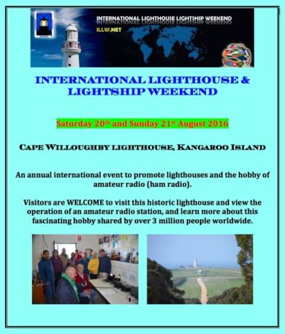
For the 2016 International Lighthouse and Lightship Weekend (ILLW), myself and 4 other members of the Adelaide Hills Amateur Radio Society, ventured over to Kangaroo Island to operate from the Cape Willoughby lighthouse.

The ILLW is NOT a contest.  It is a fun weekend to promote the plight of lighthouses and promote the hobby of amateur radio.  The ILLW came into being in 1998 as the Scottish Northern Lights Award run by the Ayr Amateur Radio Group, and has blossomed since that time.  In 2016, around 500 lighthouses were registered with ILLW to be activated.

The 2016 ILLW Cape Willoughby lighthouse team consisted of:

  1. myself, VK5PAS
  2. Chris VK4FR/5
  3. Andrew VK5CV
  4. John VK5EMI
  5. Michael VK5FVSV

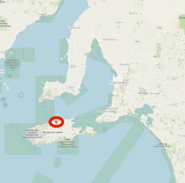
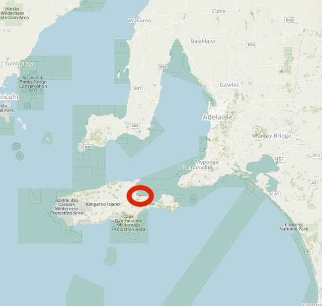
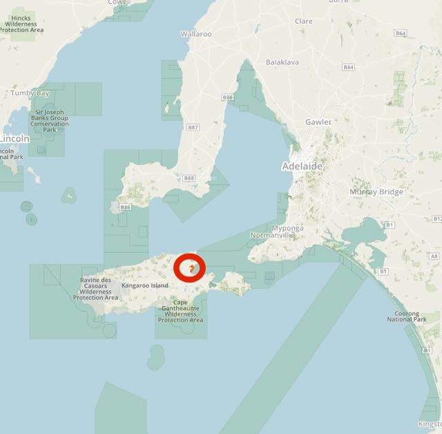
Kangaroo Island is situated about 100 km south of Adelaide, whilst Cape Willoughby is located about 28 km south east of Penneshaw.

  • Cape Willoughby lighthouse AU-0095 (ILLW)
  • Kangaroo Island OC-139 (IOTA)
  • Cape Willoughby Conservation Park 5CP-033 (VK5 Parks Award) and VKFF-1014 (WWFF)
  •  VK Shires – KI5

Screen Shot 2016-08-15 at 9.22.17 PM

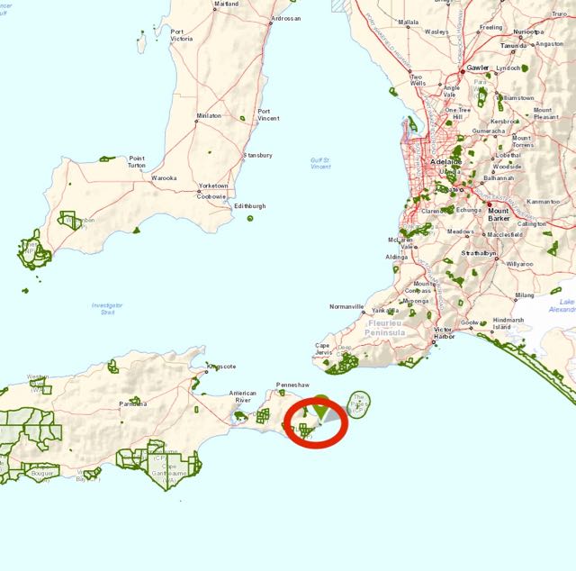
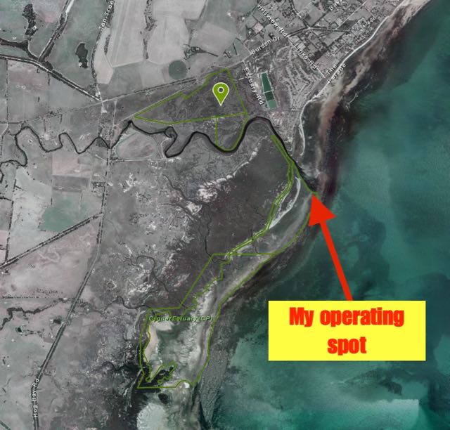
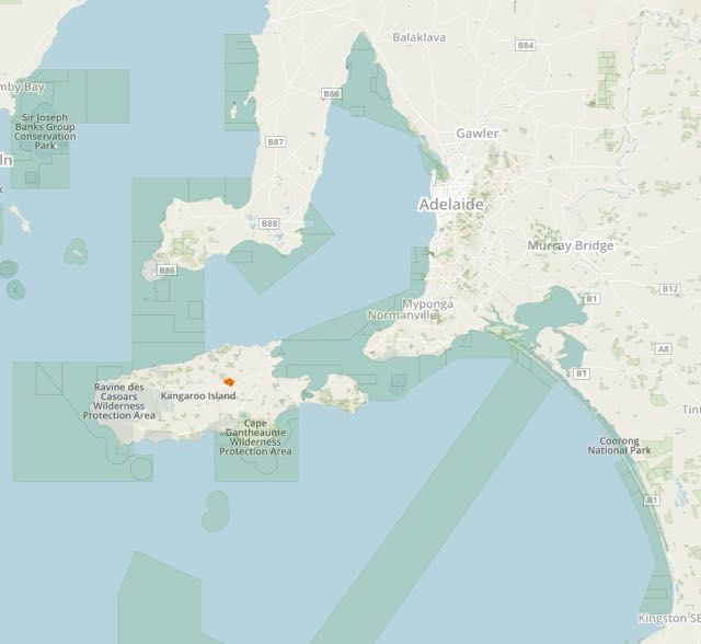
Above:-Map showing the location of Cape Willoughby on the eastern side of Kangaroo Island.  Map courtesy of Location SA Map Viewer.

It was an early start for me on Friday morning, as I had booked the 9.00 a.m. ferry over to Kangaroo Island.  The Sealink ferry departs from Cape Jervis at the tip of the Fleurieu Peninsula and travels to Penneshaw on the eastern side of Kangaroo Island.  The drive from my home to Cape Jervis takes me through the Adelaide Hills and the Fleurieu Peninsula and is a distance of around 105 km (about 90 minutes drive time).  As it was early morning there were plenty of kangaroos on the road, so it was relatively slow going.

DSC_1693.jpg

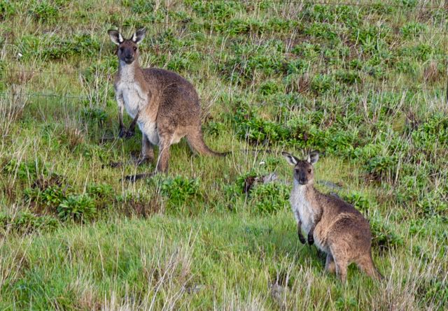
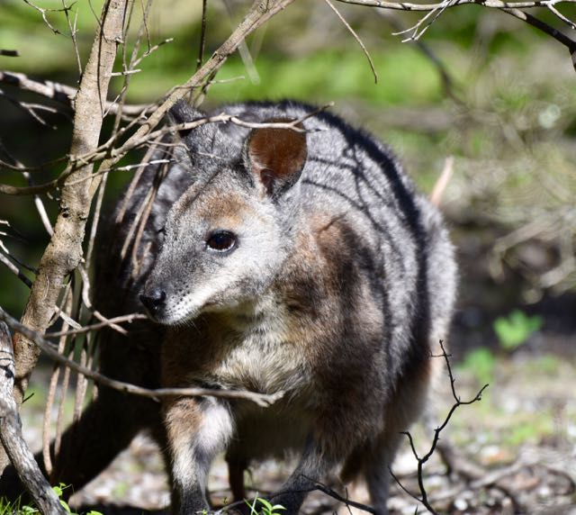
Above:- Some of the locals, Western Grey kangaroos.

The weather on Friday morning was less than ideal……quite heavy rain at times and bitterly cold.  But, what do you expect?  Its August after all, and the end of winter in Australia.  But for the hams in the United Kingdom and European where the ILLW originated, fairer weather is experienced.  There was the occasional blue patch or two in amongst the very dark clouds.  Fortunately it was not windy, so I was confident that the ferry would be able to berth at Penneshaw on the island.  Back in 2012 when we went to the island for the ILLW, we almost didn’t make it.  The weather was absolutely terrible and it took half a dozen attempts for the ferry to berth, with the Captain giving us a warning that he would try one last time.  If not it was back to Cape Jervis.  Fortunately we got there!

Despite it being a gloomy morning, the drive down to Cape Jervis took me through some beautiful countryside.  I soon was able to see the Starfish Hill windfarm, which was the very first windfarm in South Australia.  And I soon started to roll downhill towards Cape Jervis, with some great views of Kangaroo Island across Backstairs Passage.

Cape Jervis then came into view, along with the Cape Jervis lighthouse.  The little town is named after the headland at the western tip of Fleurieu Peninsula which was named on 23rd March 1802, by explorer Matthew Flinders after John Jervis, the 1st Earl of St Vincent.

Upon arrival at Cape Jervis I met up with Mike who had also booked the 9.00 a.m. ferry.  We booked ourselves and out vehicles in, and I enjoyed a nice hot cup of coffee whilst having a listen on the IC7000 in the Toyota Hi Lux.  It wasn’t long before boarding commenced on the ferry.  The Sealink ferry is around 50 metres in length and has a capacity of 250 passengers.  It can accomodate up to 55 vehicles.  The trip over to the island, which takes around 45 minutes, was quite pleasant.  The water was certainly nowhere near as choppy as I’ve experienced on previous journeys.

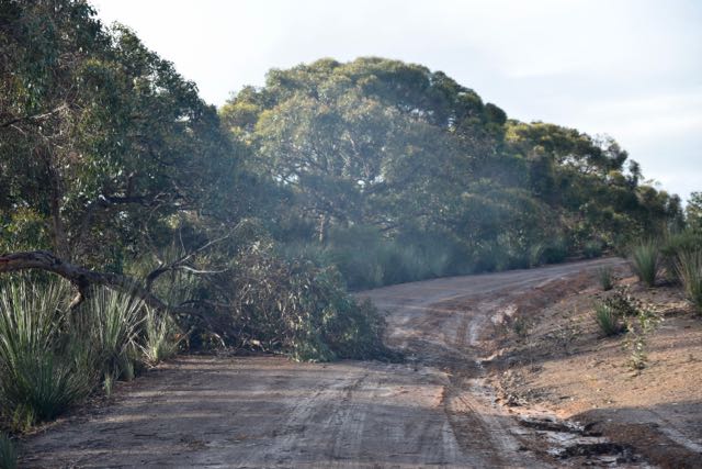
After arriving on Kangaroo Island Mike and I met up with John VK5EMI and his wife Dee.  We then drove around to the local supermarket for some provisions before heading out to the lighthouse along the Cape Willoughby Road.  We were warned that the road out to the lighthouse was terrible.  But our experience that day was that the road, which starts out as bitumen and then turns to dirt, was actually very good.  Particulary, compared to previous years.  About 3 km out from our destination, the mighty structure of the Cape Willoughby lighthouse came into view.

DSC_1744.jpg

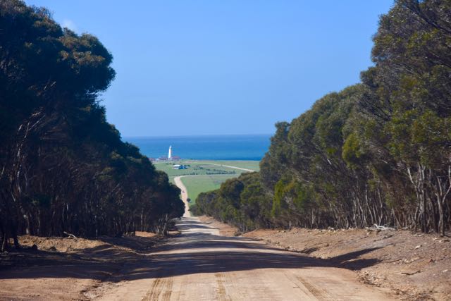
Above:- The view of the lighthouse from the Cape Willoughby Road.

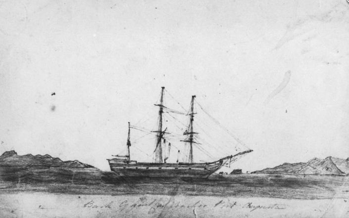
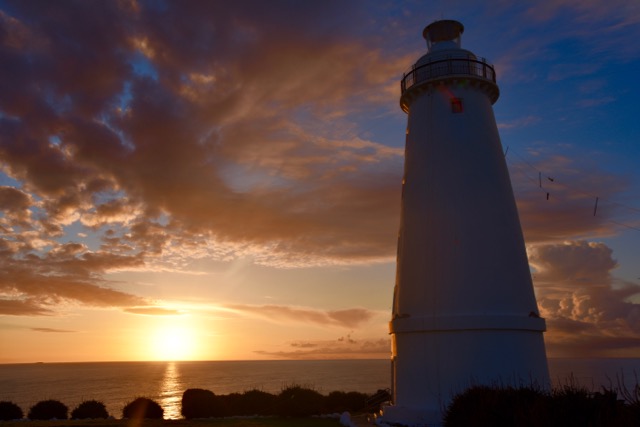
Cape Willoughby once played a vital role in the shipping trade of the young colony of South Australia before the advent of efficient forms of land transport.  The Cape Willoughby lighthouse was built to assist the safe journey of ships passing through the treacherous stretch of water known as Backstairs Passage during a time of rapidly expanding coastal shipping trade between the eastern colonies and the colony of South Australia.  The lighthouse was originally known as the Sturt Light after the explorer Captain Charles Sturt. The tower took over two years to construct and the workers lived in tents during this time. South Australia’s first lighthouse was officially opened in January 1852, and manned 24 hours a day by 3 lightkeepers who lived here with their families.

Cape Willoughby Lighthouse was constructed from locally available granite and lime mortar. Quarrying is evident near the lighthouse atop the cliffs of Devils Kitchen. It is thought holes were hand-drilled into the rock in the quarry and filled with wood. This was kept wet and the expanding wood would crack the rock which was then shaped prior to construction. The result was a circular tower of roughly dressed granite masonry.

Screen Shot 2016-08-27 at 8.43.26 PM

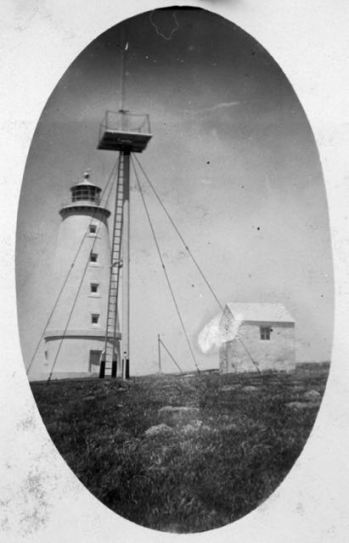
Above:- Image of the Cape Willoughby lighthouse, showing the old weather station (one of our operating spots).  Image courtesy of Trove.

The walls of the lighthouse are 1.4m thick at the base and taper to 0.86m thick at the top. The tower, from the base to the balcony, is 20.5 metres high (67 feet and 3 inches) and is round for wind resistance. The interior base of the tower is one of the widest in Australia and the lightkeepers and their families were even known to have hosted parties and dances here.

The original Deville Lantern room housed optical apparatus (light) consisting of 15 multiple wick oil burner lamps. This was reflected intermittently by revolving reflectors powered by a weight driven motor, and appeared as a flashing light. Its greatest intensity was every 1.5 minutes and in clear weather could reach 24 nautical miles.

In 1925 the lantern room and light were replaced by a more modern and powerful Chance Brothers system. The light consisted of a pressurised incandescent kerosene lantern with a three ton revolving Fresnel lens. The lens floated in a bath of mercury to reduce friction when turning. It was driven by 146lb weights which had to be wound up every 2.5 hours working on a system similar in principle as a grandfather clock. The mercury proved to be a health hazard to the lightkeepers.

In 1959 the lighthouse was electrified by two diesel powered generators installed at the station.  The lightstation became fully automated in 1974-75 when 240 volts main power was connected. A standby diesel generator and battery bank provided backup during power failure. The lantern house was also removed and was replaced with new fibreglass lantern housing. The original housing was later installed atop a stub tower in the Kingscote Museum, where it remains to this day.

The original wooden jarrah spiral staircase was also replaced with a steel structure due to wet rot and continual use.  Cape Willoughby Lightstation was one of the last manned lighthouses in Australia. It was officially automated (unmanned) in 1992.

In 2003, the lightstation was downgraded when a ML300 beacon was installed, consisting of a 35 Watt 12 Volt lamp, which is visible for 11 nautical miles. In March 2011, this was replaced with a Vega LED beacon. It is powered by two 12 Volt batteries, and the battery float is charged from the mains.

As a bonus, the lighthouse is situated in the Cape Willoughby Conservation Park, which comprises around 44 acres.  The park was established on 28th March 2002.

Screen Shot 2016-08-15 at 9.21.55 PM.jpg

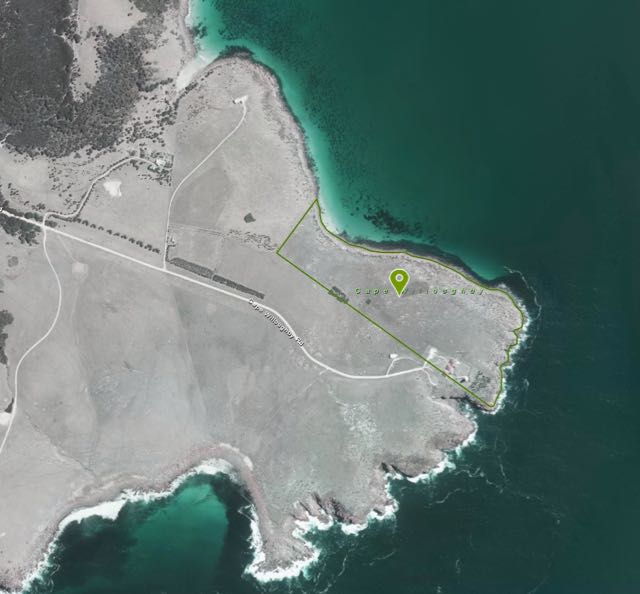
Above:- Aerial shot of the Cape Willoughby lighthouse.  Image is courtesy of Location SA Map Viewer.

When we arrived at Cape Willoughby we touched base with Adele from the Department of Environment Water and Natural Resources (DEWNR).  We were fortunate in that upon our arrival there were two whales frolicking in the adjacent Antechamber Bay.  It was a calm but cloudy morning, and Adele and commented on how nice the weather was compared to previous trips to Cape Willoughby.  But, we had spoken too soon.  It wasn’t long and it was hailing.  Cape Willoughby experiences dramatic weather changes.  Here are a few stats:

  • 23 days of gales or worse (63-130 km/hr)
  • 136 days of strong winds (50 + km/hr)
  • 2 days of hail
  • 3 days of fog
  • 8 days of thunder
  • 543 mm of rain

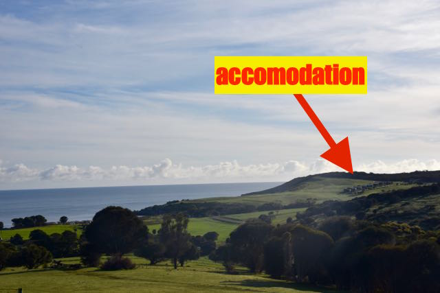
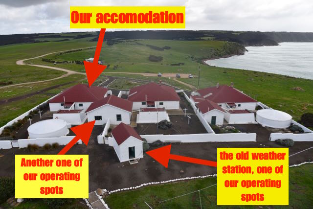
Our accomodation for the weekend was the Seymour cottage, one of the Cape Willoughby lighthouse keepers heritage cottages.  There are three cottages: the Seymour, the Thomas, and the Cawthorne.  The Cawthorne contains the DEWNR office and the visitor centre.  Both the Seymour and the Thomas can accomodate up to eight guests and contain five bedrooms.

DSC_1953.jpg

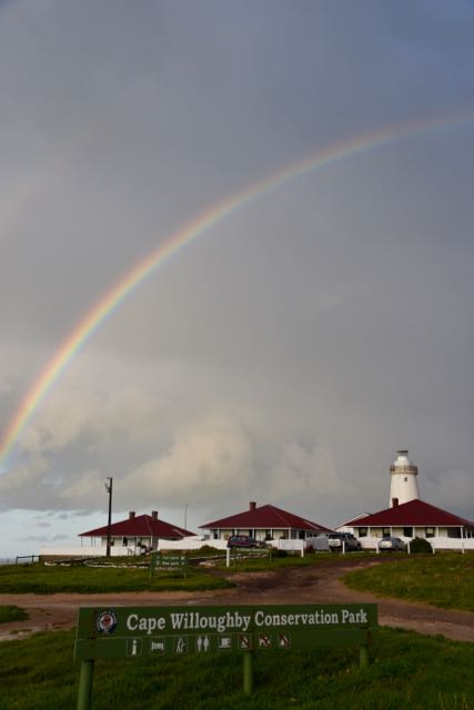
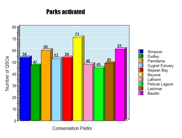
Above:- View of the three old lighthouse keepers cottages and the lighthouse.

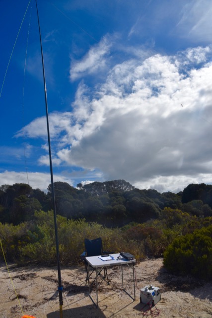
We commenced the arduous task of unpacking and Mike, John and I then commenced setting up some stations.  Once Andrew and Chris had arrived in the early afternoon it was time to start erecting the antennas.  We are fortunate in that we are allowed access to the lighthouse, and we established a halyard to allow us to hoist up some antennas.

We even set up a 160m antenna, hoping for some action on that band.  Each end of the 160m dipole was supported by some painters poles.

DSC_1794.jpg

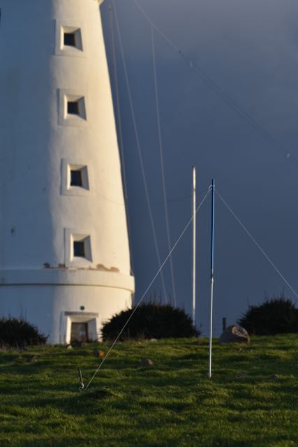
Above:- the 160m antenna.

Our antennas comprised the following:

  1. broadband folded dipole
  2. 80/40/20m linked dipole.
  3. Hex beam
  4. 160m dipole
  5. Par end fed

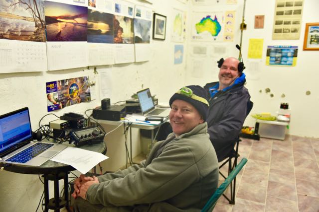
It took quite a few hours to set up our gear whilst battling variable weather conditions.  A phone and a separate digital station were established in the old weather station, whilst a further two stations were set up in the shed/museum at the back of the Seymour cottage.

Friday evening was pizza night.  Andrew was put to the test with his home made pizza skills and I must say he did very well.  All washed down with a few bottles of very nice red.

After tea, Chris had a bit of a play on the digital modes (JT65 and PSK31), working into Asiatic Russia, European Russia, USA, and Japan on both 40m and 20m.   Leo in Georgia USA Chris’ very first contact in the log for VK5CWL on JT65.  Nori JA7FLI was our first contact in the log on PSK31.  The digi set up consisted of an Elecraft K3 and Signal link device.

Meanwhile, I scouted across the 40m band on SSB, working a number of VK’s, New Zealand, French Polynesia, Papua New Guinea, and the USA.  Our first SSB contact in the log was with Peter VK2NEO near Leeton in New South Wales.  I also booked in to the 7130 DX Net and made a number of contacts there.  The SSB station in the weather station consisted of a Yaesu FT-450.

Andrew operated from the museum and logged a number of contacts on the 80m band in VK2, VK3, VK4, VK5, and New Zealand.  The two museum stations included a Flex Maestro (very nice!!!).

A handful of lighthouse stations were logged on Friday evening.  They were:

  • VK6CLL, Cape Leeuwin lighthouse AU-0008 within the Leeuwin-Naturaliste National Park VKFF-0283
    • 40m
  • VK5ARC/p, Point Malcolm lighthouse AU-0029
    • 40m
  • VK2ATZ/p, Norah Head lighthouse AU-0024
    • 40m


DSC_1803

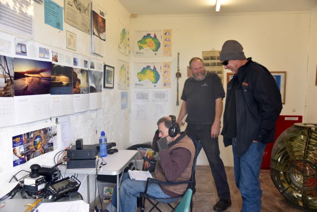
Above:- Chris VK4FR/5 and Paul VK5PAS, operating in the old weather station.

It had been a long day, so we all retired relatively early, expecting a big Saturday.  We had a total of 50 contacts in the log already, in seven different countries (Australia, Asiatic Russia, French Polynesia, Japan, New Zealand, Papua New Guinea, and USA).

DSC_1804.jpg

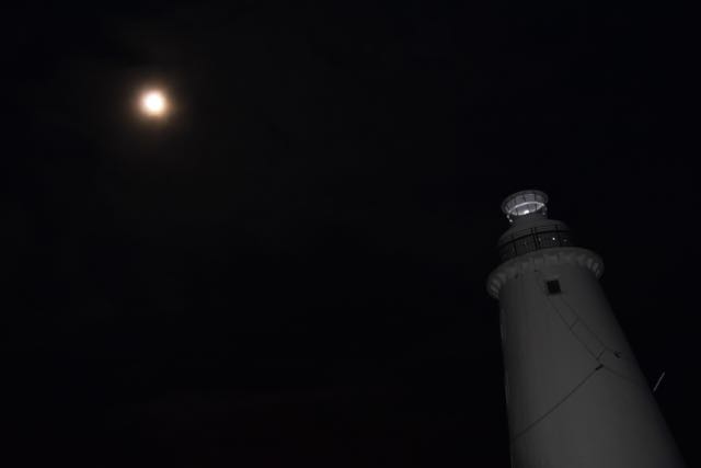
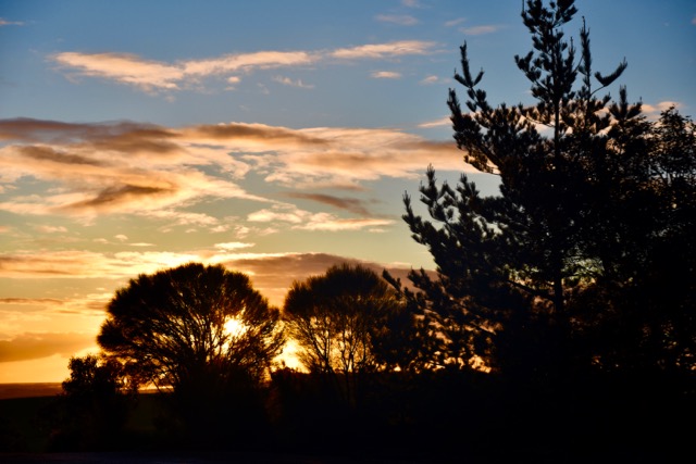
I had slept pretty poorly on Friday night, so it was an early start for me on Saturday morning (2oth August 2016).  And I’m very pleased it was, because I was rewarded by an amazing sunrise and an incredible moon.  What I was very pleased with, was that Saturday morning was nice and calm and clear.  Very chilly, but very calm.  Certainly a morning ‘to bottle’ at Cape Willoughby.   I snuck in a little activity on 40m, working around 17 stations before breakfast.  The first station in the VK5CWL log for Saturday was Lewis VK2FGLB in Sydney.  This was closely followed by husband and wife team, Joe VK3YSP and Julie VK3YSP operating portable at the Queenscliff lighthouse AU-0051.  Joe and Julie are a dynamic team who are always promoting amateur radio.

After breakfast it was time to start filling up the VK5CWL logbooks.  Andrew commenced on 80m and later moved to 160m whilst John operated on 40m working into VK2, VK3, VK5, and VK7.  Mike hit the 20m band and worked a number of lighthouse stations in VK2 and New Zealand.  And Chris got back into the digital modes.  As the day progressed, we changed operators, alternating between bands and stations.

Because the weather on Saturday was quite good, we had a steady flow of visitors out to Cape Willoughby and there was some significant engagement with onlookers.  I had brought along ‘Calling CQ’ brochures from the WIA, and brochures regarding the VK5 National & Conservation Parks Award, and the World Wide Flora Fauna (WWFF) program.  We all took time out to explain the hobby of amateur radio and why we were operating from the lighthouse.

DSC_1857.jpg

Above: John VK5EMI at the mic being watched on by some amused spectators.

We had also circulated a number of promotional flyers which were put on display at various tourism venues around the island.

ILLW 2016 promo

Saturday night was lasagne night.  My wife Marija had made up some home made lasagne, which again, surprise surprise, was accompanied by further bottles of red wine.   We certainly did not go hungry on this trip.

DSC_1885

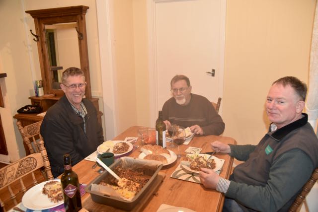
Above: Lasagne night.  Mike VK5FVSV, John VK5EMI & Andrew VK5CV

Some of the more interesting contacts during Saturday were with special event station VI6BLT50 to commemorate the Battle of Lang Tan, and also Heath VK3TWO/6 who was on Barrow Island OC-140 off the coast of Onslow in north west Western Australia.  We also spoke with Gavin VK7FLI on Flinders Island.  Ian VK5CZ gave us a call whilst he was on the top of SOTA peak Mount Benjamin VK5/ NE-083.  And we logged YB71RI/0.  This special event station (SES) is to commemorate the 71st Indpendence Day of the Republic of Indonesia.

A bit of fun was had again on JT65, with contacts into India, Ukraine, France, Japan, China, Alaska, Indonesia, and Reunion Island.

DSC_1864.jpg

Above:- view from the top of the lighthouse.

Only a small amount of DX was worked on 20m SSB, as the multiband folded dipole was not performing well.  Contacts were made into Alaska, Russia, USA, England, Canary Islands, Ukraine, and Portugal.

By the end of Saturday (20th August 2016) we had logged a further 224 QSOs.  This included the following lighthouse stations:

  • VK3YSP/p, Queenscliff lighthouse AU-0051
    • 40m
  • VK3FOWL/p, Queenscliff lighthouse AU-0051
    • 40m
  • VK4BAR/p, Cleveland Point lighthouse AU-0014
    • 40m, 20m
  • VK2/GW0VML/p, Ballina lighthouse AU-0001
    • 20m
  • ZL1KBR/p, Bean Rock lighthouse NEW ZEALAND NZ-0011
    • 20m
  • VK3VTH/7, Curry Head lighthouse AU-0016 King Island
    • 40m
  • ZL2X, Pencarrow lighthouse NEW ZEALAND NZ-0012
    • 20m
  • ZL6LH, Piha lighthouse NEW ZEALAND NZ-0006
    • 20m
  • VK6CNL, Cape Naturaliste lighthouse AU-0010
    • 20m
  • VK6CLL, Cape Leeuwin lighthouse AU-0008
    • 20m
  • VK3ATL/p, Point Lonsdale lighthouse AU-0050
    • 40m
  • VK4CHB, New Burnett Heads lighthouse AU-0104
    • 20m
  • VK3SPL, Split Point lighthouse AU-0032
    • 40m
  • VK2MB, Barronjoey lighthouse AU-0046
    • 40m, 20m
  • VK7LH, Low Head lighthouse AU-0048
    • 80m, 40m
  • VK7TAZ, Eddystone Point lighthouse AU-0087
    • 80m, 40m
  • VK5CJ, Cape Jaffa lighthouse AU-0007
    • 40m
  • VK5PBZ/p, Port Germein lighthouse AU0069
    • 40m
  • VK3APC/p, Eastern Light Mcrae AU-0017
    • 160m, 80m, 40m.
  • VK3OLS, Cape Otway lighthouse AU-0011
    • 40m
  • VK6BRC/p, Casuarina lighthouse AU-0086
    • 20m
  • VK2BOR/p, Tacking Point lighthouse AU-0034
    • 40m, 20m
  • VK2LR/p, Clarence Head lighthouse AU-0013
    • 20m
  • VK2EP, Smoky Cape lighthouse AU-0031
    • 40m
  • VK7HKN/p, Cape Tourville lighthouse AU-0119 in Freycinet National ParkVKFF-0188
    • 40m
  • VK5ARC/p, Point Malcolm lighthouse AU-0029
    • 160m, 40m, 20m
  • VK5CJL, Cape Jervis lighthouse AU-0094
    • 160m, 80m 20m
  • VK4BW, Burnett Heads Historical lighthouse AU-0004
    • 40m
  • VK7NWT/p, Round Hill Point lighthouse AU-0111
    • 80m
  • VK2HBG/p, Warden Head Ulladulla AU-0035
    • 40m
  • VK3DX, Lady Bay Upper & Lady Bay Lower Warrnambool AU-0049 & AU-0096
    • 80m
  • VK6AHR/p, North Mole lighthouse, Fremantle AU-0073
    • 80m

Sunday morning (21st August 2016) was another beautiful morning at Cape Willoughby.  Again it was quite calm and there was no rain. We had been quite blessed with the weather.  There was a clear view out to The Pages Conservation Park, and the Aloe Vera plants leading to the lighthouse were alive with Superb Blue Wrens.

Our first contact for Sunday morning was on 40m with Mal VK6LC operating with the special call of VI6BLT50 to commemorate the Battle of Lang Tan.  A number of other interesting contacts were made on Sunday including a QSO with Gerard VK2IO who was portable in the Sydney Habour National Park VKFF- 0473.  We also worked Ian VK5CZ on SOTA peak Mount Arden VK5/ NE-034, and Tony VK1VIC/2 and VK1RX /2 who were on SOTA peak Dampier VK2/ST-007.  We also logged the Battle of Long Tan station, VI4BLT50 and Neil VK4HNS/2 portable in Kwiambi National Park VKFF-0274.

Another one of the Indonesian special event stations, YB71RI/7 was logged on 40m.  Another very interesting contact was with Jack VK7IL, whose father was a lighthouse keeper on King Island.  We also spoke with Brenton VK3YB running just 500 milliwatts from his Double Sideband (DSB) transceiver.  Peter VK3YE also made it into the log, operating QRP with 5 watts on Chelsea Beach.

Sunday also saw an improvement for us in the DX stakes on 20m SSB.  We had erected a SOTAbeams 20m/40m linked dipole and used this instead of the broadband folded dipole. Chris and I put this up in the absolute pouring rain, and I headed off for a hot shower after we had got the antenna up in the air.  There was no comparison.  A large number of stations were worked in Europe as a result.  John and I had a nice little pile up going there at one stage.  If only we could have worked out in time, how to go split on the 450.

By the end of Sunday we had logged a further 253 stations, including the following lighthouse stations:

  • VK2HBG/p, Warden Head Ulladulla lighthouse AU-0035
    • 40m
  • VK3VTH/p, Currie Light King Island AU-0016
    • 40m
  • VK4GHL, Grassy Hill lighthouse AU-0019
    • 40m
  • VK3DNQ/p, Cape Nelson lighthouse AU-0055
    • 40m
  • VK3DX, Lady Bay Upper and Lady Bay Lower AU-0049 and AU-0096
    • 40m
  • VK7NWT/p, Round Hill Point AU-0111
    • 40m
  • VK6CNL, Cape Naturaliste lighthouse AU- 0010
    • 20m
  • VK7LH, Low Head lighthouse AU-0048
    • 40m
  • VK6CLL, Cape Leeuwin lighthouse AU-0008
    • 20m
  • VK4CHB, New Burnett Heads lighthouse AU-0104
    • 20m
  • GB2GNL, Girdleness lighthouse SCOTLAND UK-0037
    • 20m
  • VK4AAC/3, Cape Schanck lighthouse AU-0012 in the Mornington Peninsula National Park VKFF-0333
    • 40m

Monday morning’s sunrise was no less spectacular than that of the previous two mornings.  It was a very calm, but very brisk morning at Cape Willoughby.  There was a little bit of time for radio activity before packing up the gear and calling it quits for another ILLW event.

DSC_1973.jpg

I made a handful of contacts on 40m as did John VK5EMI, whilst Andrew VK5CV made some contacts on 80m.  It was very slow going with very long periods of CQ calls with no replies.  But we did manage to have three more lighthouse contacts:

  • VK3SRC, Queenscliff lighthouse AU-0051
    • 40m
  • VK3SPL, Split Point lighthouse AU-0032
    • 40m
  • VK7LH, Low Head lighthouse AU-0048
    • 40m

And we also made contact with Neil VK4HNS who was portable at the Kwiambi National Park VKFF-0274.  Another 20 QSOs were added to the VK5CWL log on Monday morning.  Our final contact as VK5CWL for the ILLW 2016 was with Peter VK5AWP, with John VK5EMI at the mic at VK5CWL.

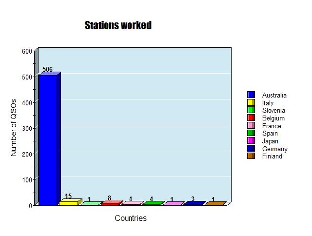
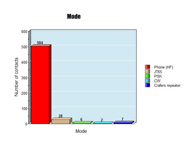
Our final QSO count for the 2016 ILLW was 547 contacts on the 160, 80, 40, 30, 20 and 2 m bands, on PHONE, CW, PSK, and JT65.  We worked a total of 36 different countries.  A breakdown of our contacts is as follows……

  • 504- PHONE (HF)
  • 28 – JT65
  • 6 – PSK31
  • 2 – CW
  • 7 – 2m Crafers repeater

VK5CWL Modes.jpg

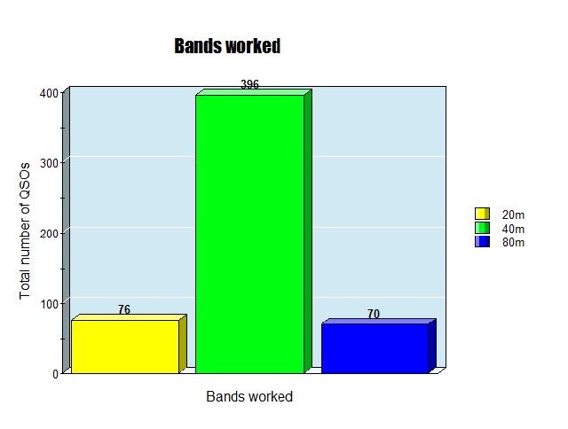
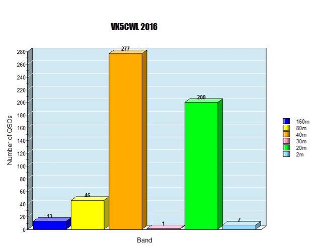
Whilst at Cape Willoughby we tried as many bands as possible.  We even gave 10m and 15m a go, but despite numerous CQ calls at various times of the day, we had no takers.  Most of our activity, not surprising, was on the 40m band with a total of 277 QSOs.  Followed by 20m, where a lot of DX in Europe was worked.  And then followed by 80m.  But we did have some fun on 160m, making 13 contacts into VK2, VK3, VK5, and VK6.

Screen Shot 2016-08-27 at 3.44.13 PM.jpg

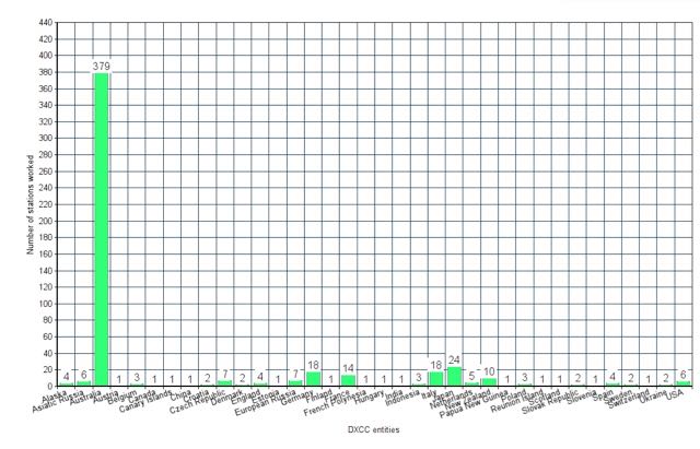
A total of 36 different DXCC entites were logged.  Countries (DXCC entities) worked were as follows:

  1. Alaska
  2. Asiatic Russia
  3. Australia
  4. Austria
  5. Belgium
  6. Canada
  7. Canary Islands
  8. China
  9. Croatia
  10. Czech Republic
  11. Denmark
  12. England
  13. Estonia
  14. European Russia
  15. Germany
  16. Finland
  17. France
  18. French Polynesia
  19. Hungary
  20. India
  21. Indonesia
  22. Italy
  23. Japan
  24. Netherlands
  25. New Zealand
  26. Papua New Guinea
  27. Poland
  28. Reunion Island
  29. Scotland
  30. Slovak Republic
  31. Slovenia
  32. Spain
  33. Sweden
  34. Switzerland
  35. Ukraine
  36. USA

Screen Shot 2016-08-27 at 5.23.31 PM.jpg

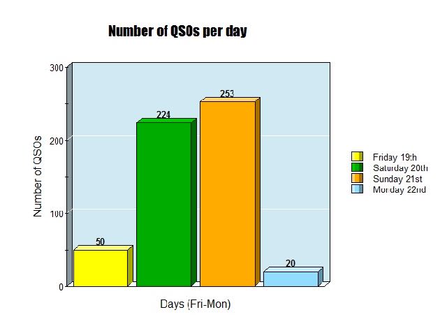
As was to be expected most of our activity was over the weekend itself – Saturday and Sunday.   A total of 224 QSOs were made on Saturday and 253 on Sunday.  See the bar graph below….

Screen Shot 2016-08-28 at 9.24.23 PM

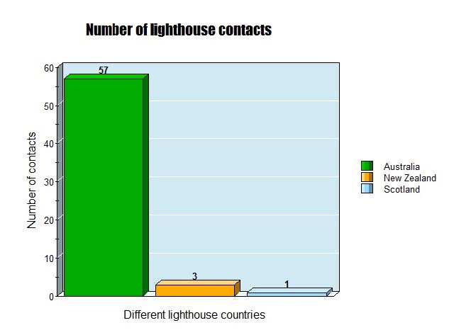
We made a total of 61 contacts with other lighthouses around the world.  The majority of those were in Australia (a total of 57), but we did work 3 lighthouses in New Zealand, and one in Scotland.  Of the 65 Australian lighthouses that were listed as entrants for 2016 on the ILLW page, we worked 31 of them.  Almost 50%.  Along with three more that were not recorded on the list.

Screen Shot 2016-08-28 at 11.13.56 PM

All in all, another very enjoyable and successful ILLW weekend at Cape Willoughby.  Thanks as always to the DEWNR staff at Cape Willoughby.  They cannot help enough.  We highly recommend a stay here.  And also thanks to Transport SA for allowing us to use the railing of the lighthouse.

Please remember our website which can be found at…..

http://vk5cwl.weebly.com/

If you would like a QSL card for VK5CWL, we will QSL via the Bureau, Direct, eQSL and LOTW.  Until next year.


References.

Government of South Australia, 2016, <http://www.environment.sa.gov.au/parks/Find_a_Park/Browse_by_region/kangaroo-island/cape-willoughby-conservation-park&gt;, viewed 17th August 2016

Wikipedia, 2016, <https://en.wikipedia.org/wiki/Cape_Willoughby_Conservation_Park&gt;, viewed 17th August 2016