Point 756 Pyrenees VK3/ VS-018

My final activation for my trip away to Victoria was an activation for the Summits on the Air (SOTA) program at SOTA peak Point 756 Pyrenees VK3/ VS-018.  The summit is located in the Pyrenees Range north of Ararat in western Victoria.

screen-shot-2016-11-21-at-8-08-55-pm

Above:- Map showing the location of the summit.  Map courtesy of google maps.

VK3/ VS-018 is 756 metres above sea level and is worth 4 points.  I have activated this summit twice previously, back in December 2015 and September 2014.  To read about those activations please check out my previous posts at….

https://vk5pas.org/2015/12/12/point-756pyrenees-vk3-vs-013/

https://vk5pas.org/2013/09/14/point-756pyrenees-vk3-vs-018/

It was around an 11 km drive from Blue Mountain to this summit, along some of the dirt tracks in the Pyrenees Range.  Along the way I enjoyed some beautiful views of the Pyrenees.  The views are limited as the vegetation along the roads is very thick, but there are the occasional breaks.

After leaving Blue Mountain summit, I travelled back along Blue Mountain Track and then on to Main Break until I reached Sanderson Track.  This track leads directly to the summit.  I have previously aaccessed this summit by another track a little further to the north.  That particular track is un-named.

The summit itself is located in a clearing on Sanderson Track amongst the forest.

Screen Shot 2016-11-21 at 8.08.39 pm.jpg

Above:- Aerial shot showing the location of the summit.  Image courtesy of google maps.

I pulled up in the clearing and as this was a nice and easy drive up summit I was able to use the fold up table and deck chair.  I ran the Yaesu FT-857d, 20 watts, and the 80/40/20m linked dipole for this activation.  I was all set to go by 0040 UTC (11.45 a.m. Victorian local time).  I started calling CQ on 7.090 and this was answered by Adam VK2YK mobile with a good strong 5/8 signal.  This was followed by Peter VK3PF, Steve VK7CW, and then Geoff VK3SQ.  I had qualified the summit.

Contact number eleven was Rob VK4AAC/3 who was portable in the Grampians National Park VKFF-0213.  Rob’s signal was very strong.  I worked a total of 21 stations on 40m from VK3, VK4, VK5, and VK7, before I QSYd to 14.210 on 20m.  There I worked just 4 stations: John VK4TJ, Gerard VK2IO, Geoff VK3SQ, and Tim VK2BT.  Numerous other CQ calls went unaswered.

I then tried my luck on 3.610 on 80m where I spoke with Geoff VK3SQ in Beechworth (5/9 sent and 5/6 received) and Rob VK4AAC/3 in the Grampians National Park (5/3 both ways).  The 80m band continues to provide some very interesting results.

I then moved back to 40m where I worked a further 6 stations including Mick VK3PMG/VK3GGG who was portable in the Alpine National Park VKFF-0619.

My fun in parks and summits had come to an end.  I had around a 500 km drive back home.  And by the time I arrived home I had clocked up around 2,400 km for the entire trip.

The following stations were worked:-

screen-shot-2016-11-21-at-7-56-42-pm

Below is a map showing my route back home to Mount Barker from Ararat via the Western and Dukes Highways.

screen-shot-2016-11-21-at-10-46-21-pm

Blue Mountain VK3/ VS-015

On Thursday morning 17th November 2016 I booked out of the motel at Ararat and headed out to the Pyrenees with the intention of activating two summits before making the 500 km journey back home.  My first planned summit was Blue Mountain VK3/ VS-015.  This was to be the third time that I had activated this summit for the Summits on the Air (SOTA) program.

screen-shot-2016-11-21-at-7-22-23-pm

Above:- Map showing the location of Blue Mountain VK3/ VS-015.  Map courtesy of google maps.

I headed out of Ararat along the Pyrenees Highway until I reached the Landsborough-Elmhurst Road.  There is a sign here indicating the Pyrenees Range.  I then took the Glenlofty-Warrenmang Road and travelled passed the Pyrenees State Forest.

I soon reached Blue Mountain Track and started climbing up into the Pyrenees and soon entered the Landsborough Flora and Fauna Reserve.  The track here is definitely 4WD only.

I then reached the junction of the Blue Mountain Track and the Barkly Track.  You need to take a sharp left here and continue along the Blue Mountain Track.

dsc_3937

The summit itself is located near the intersection of the Blue Mountain Track and the Malakoff Track.

This truly is beautiful country.  There are the occasional views of the surrounding countryside through the trees.  The Victorian National Parks Association has proposed that the Landsborough Nature Conservation Reserve be reclassified to become a State park, along with the Percydale Historic Area, and the Landsborough Hill Nature Conservation Reserve.

screen-shot-2016-11-21-at-7-20-56-pm

Above:- Aerial shot showing the location of Blue Mountain VK3/ VS-015.  Image courtesy of google maps

After setting up the deck chair and the fold up table and the associated radio equipment, I commenced calling CQ on 7.090.  It wasn’t long before I had my first caller and this was Steve VK7CW with his normal very strong 5/9 signal.  This was followed by Ivan VK5HS mobile, and then Peter VK3PF and Rod VK7FRJG..  I worked a total of 10 stations, qualifying the summit, before I tried 80m.  Sadly I had just missed out on a Summit to Summit contact with Adam VK2YK who had just packed up at his summit.

I only managed one contact on 3.610 on 80m and that was Adam VK2YK who had followed me down from 40m.  I then tried 14.310 on 20m where I worked 6 stations including John ZL1BYZ in New Zealand.

dsc_3940

To complete the activation I headed back to 7.090 on 40m and there worked a further 5 stations from VK3, VK4, and VK5.  It was time to pack up and head off to my next summit, Point 756 Pyrenees VK3/ VS-018.

The following stations were worked:-

screen-shot-2016-11-21-at-7-08-49-pm


References

Victorian National Parks Association, 2016, <http://vnpa.org.au/page/nature-conservation/protecting-special-places/mt-cole-state-forest&gt;, viewed 21st November 2016

One Tree Hill VK3/ VS-036 and Ararat Hills Regional Park VKFF-0958

On Wednesday morning Andrew VK6AS and I left the home of Lee VK3GK and negotiated the Melbourne traffic and made our way down to Geelong.  We there delivered a presentation to members of the Geelong Amateur Radio Club on the Wireless Institute of Australia (WIA).  It was well attended and well received, and at the conclusion of the talk a group of us headed across the road for a meal at the hotel.

I then dropped Andrew off at the Geelong railway station and I made my way to Ararat in western Victoria where I had planned to stay overnight.  My intention late that afternoon and into the evening was to activate One Tree Hill VK3/ VS-036 which is located within the Ararat Hills Regional Park VKFF-0958.

screen-shot-2016-11-21-at-5-30-16-pm

Above:- Map showing the location of One Tree Hill & the Ararat Hills Regional Park.  Map courtesy of Open Street Map

The summit and park is easy to locate and well signposted.  I accessed the park via Picnic Road and then One Tree Hill Road.

One Tree Hill is 569 metres above sea level and is worth 2 points in the Summits on the Air (SOTA) program.  I have activated this summit a few times previously but I have never activated the park for the World Wide Flora Fauna (WWFF) program.  The road will take you all the way to the carpark and lookout, where the communications tower is located.  However this is not the actual summit.  You will either need to drive a bit further along the 4WD track or take a casual walk along the track to the summit.

dsc_3913

The summit itself does not offer great views as they are obscured by trees.  However you can be rewarded with some great views of the Grampians, The Pyrenees, Ararat, and the surrounding countryside from the lookout carpark.

This slideshow requires JavaScript.

It is interesting to note that SOTA shows the high point a little further north of One Tree Hill and Snake Hill and a little south east of Napolean Hill.

screen-shot-2016-11-21-at-5-29-53-pm

Above:- Map showing the location of the summit.  Map courtesy of Open Street Map

As this was a nice easy drive up summit I had the luxury of my fold up table and deck chair.  I ran the Yaesu FT-857d at 40 watts for this activation, with the 80/40/20m linked dipole, supported on the 7m heavy duty squid pole.  I was set up and ready to go by 5.30 p.m. Victorian local time.  I was unable to get on to 7.144 as there were some stations nearby so I slipped down a little lower to 7.140 and started calling CQ.

My CQ call was answered by John VK5BJE, followed by Rob VK2FAAA mobile, Rod VK7FRJG, and then Ian VK1DI.  I had qualified the summit.  Unfortunately about 10 minutes into the activation some New Zealand stations came up on the frequency and started having a chat.  Clearly they were unable to hear me and kindly QSYd when asked by a VK running a lot more power than me.  However they QSYd to 7.138, just 2 kc below me and I continued to experience QRM which made it a little hard with the weaker stations that were calling in.

I worked a total of 33 stations on 40m from VK1, VK2, VK3, VK4, VK5 and New Zealand.  The ZL callers were Wynn ZL2ATH in Wellington and John ZL1BYZ in Pukekohe.  Although they were both strong to me, they were struggling a little with my signal across the Tasman Sea.

I also made a Summit to Summit and Park to Park contact with Andrew VK1AD who was activating Black Mountain VK1/ AC-042 in Black Mountain Nature Reserve VKFF-0834.

The band was very busy and at one stage I had F6ECS on the same frequency and also W1ZY calling CQ DX.  So I decided to QSY and try 20m.

I headed to 14.310 and started calling CQ and this was answered by Gerard F1BLL in France, followed by John VK6NU.  It was at this time that the Over the Horizon radar started up on 20m and I also started to get some bleedover from 14.307.  It didn’t look like it was my day.  But I did have some DX success working a total of 11 DX stations on 20m from Italy, France, Germany, Japan, Belgium, Czech Republic and New Zealand.

I also worked Andrew VK1AD again, on a new band from VK1/ AC-042 and VKFF-0834.  This just so happened to be Andrew’s 10,000th logged SOTA activator QSO.  What an amazing effort.  For more information on Andrew’s activation, please see his blog at…..

https://vk1nam.wordpress.com/2016/11/21/sota-milestone-10000-qsos/

I then lowered the squid pole and inserted the links for the 80m section and headed to 3.610 where I started calling CQ.  This was answered by John VK5NJ in Mount Gambier who was 5/9 plus to One Tree Hill.  I worked a further 7 stations on 80m from VK2, VK3, and VK5.

I then moved back to 40m where I booked in to the 7130 DX Net.  I worked a total of 13 stations on the net, from French Polynesia, New Zealand, VK2, VK5, VK6, VK7, and VK8.  When things became a little quiet on the net I had a quick tune across the band and worked special event call VI50DC celebrating the 50th anniversary of the introduction of decimal currency in Australia.

The 7130 DX Net had completed and it was now dark and it was time for me to head back to the motel room.  I had a total of 74 contacts in the log.

The following stations were worked:-

screen-shot-2016-11-21-at-5-14-46-pmscreen-shot-2016-11-21-at-5-14-50-pm

WIA presentations in Melbourne

On Tuesday 15th November 2016 Andrew VK6AS and I had two scheduled Wireless Institute of Australia (WIA) presentations to deliver in Melbourne.  So it was a fairly early start from Brenton VK3CM’s house at Tangambalanga where we had stayed overnight.

After breakfast we were on the road to Melbourne, a 350 km journey.  Along the way we dropped Brenton off in Benalla so that he could pick up his recently worked on Porsche.

Once in Melbourne Andrew and I headed to the clubrooms of the Frankston and Mornington Peninsula Amateur Radio Club (FAMPARC).  It was a well received presentation and it was nice to catch up with a few people I had spoke with on our but never met in person.

15055623_10209857130297139_653120437809303798_n

screen-shot-2016-11-20-at-12-43-37-pm

At the end of this presentation we headed to the clubrooms of the Eastern and Mountain District Amateur Radio Club (EMDRC).  We enjoyed a sausage sizzle and mixing and chatting with the large number of attendees, before delivering our presentation.

screen-shot-2016-11-20-at-12-43-38-pm

At the conclusion of evening at EMDRC we headed to the home of Lee VK3GK who had kindly offered his house to stay at overnight.  Many thanks Lee.

Mount Baranduda VK3/ VE-189 and Baranduda Regional Park VKFF-0959

After picking up Andrew VK6AS from the ALbury Airport we headed to SOTA summit Mount Baranduda VK3/ VE-189 which is located within the Baranduda Regional Park VKFF-0959.

screen-shot-2016-11-09-at-11-44-31-am

Above:- Map showing the location of the Baranduda Regional Park in north eastern Victoria.  Map courtesy of google maps.

Mount Baranduda, a granite outcrop, is an isolated area of high country in the Baranduda Range.  The summit is designated as VK3/ VE-189 for the Summits on the Air (SOTA) program.  It is 775m / 2543ft above sea level in height and is worth 4 SOTA points.

The park is home to a large amount of native wildlife.  This includes the rare Spot-tailed quoll.  Wild deer can also be found in the park.  Silky Swainson-pea Swainsona sericea is a prostrate or erect pennial which grows to around 10 cm tall.  The plant had not been recorded in the area for over 50 years and was re-discovered in 2007 on the north west slopes of the Baranduda Regional Park.

swainsona_sericea2_nr_cooma_fagg

Above: Silky Swainson-pea.  Image courtesy of Environment NSW.

Baranduda pastoral run was taken up in 1845 and it is thought that the name was derived from an Aboriginal expression relating to a swamp or a water rat.  Baranduda was a rural hamlet with numerous German farm selectors, who came from South Australia.  Beginning with the grazing of cattle, dairying and sawmilling were added, serving markets in Wodonga and providing timber sleepers for railway construction. A school was opened in 1880 and an inter-denominational church in 1912.  A memorial hall was built in 1955.

Andrew and I approached the park and the summit from the south, following the Beechworth-Wodonga Road until we reached Ewarts Road.

You immediately enter the park at this point, but we wanted to get to the summit itself, so we continued to follow Ewarts Road, admiring the view along the way.  We soon reached a gate which read ‘Road Closed.  Private property unauthorised persons prohibited.  Please shut gate’.  I had read on another activator’s blog that the gentleman who owned the property did not mind amateurs accessing the summit this way.  So Andrew and I entered the property and drove up the gentleman’s house and had a chat with him.  He was fine with us accessing the summit this way, so long as we shut gates.

We followed the track up to Mount Baranduda.

screen-shot-2016-11-09-at-11-41-53-am

Andrew and I decided to share the mic during this action and we headed to 7.090 where we commenced calling CQ.  Our first taker was Col VK3LED, but it wasn’t long and the Kandos Group started up on 7.093 and we were being wiped out.  So we headed up to 7.105 and again started calling CQ.  This was answered by Peter VK2NEO, Mick VK3PMG/VK3GGG and then Bill VK3LY.  Andrew and I were happy.  We had qualified the summit.

We were pushed a little for time so we did not expect to reach the required 44 QSOs for the global World Wide Flora Fauna program, but we were keen to get 10 QSOs and qualify the park for the VKFF program.  We were able to do that when Steve VK7CW called us, with a beautiful 5/9 signal.

Andrew and I worked a total of 21 stations on 40m until things started to really slow down.  We decided to give 80m a go, and after inserting the links in the dipole we headed to 3.610 on 80m and started calling CQ.  This was answered by Peter VK3ZPF and then Rob VK2QR.  We also spoke with Gerard VK2IO who was activating Bugong National Park VKFF-0063.

We then headed to 20m and called CQ but sadly there were no takers, so it was a quick look on 40m again where we logged a further 5 stations.  In all we ended up with a total of 30 contacts each, falling 14 short of the required 44.  It will need to be a return visit to this park.

I worked the following stations:-

Screen Shot 2016-11-21 at 4.22.40 pm.jpg

At the conclusion of the activation Andrew and I headed to the Tangambalanga Hall and there delivered a presentation on the Wireless Institute of Australia (WIA).

15056332_10211126403865368_2976894075677222774_n.jpg

At the end of the evening we headed back to the home of Brenton VK3CM.  Brenton and his lovely wife Sam had kindly offered their home for us to stay overnight.


References.

ABC, 2016, <http://www.abc.net.au/local/stories/2015/03/06/4192471.htm&gt;

Victorian Landcare, 2016, <https://www.landcarevic.org.au/groups/northeast/baranduda-landcare-group/copy-of-rare-swainsona-survey/&gt;

<http://www.victorianplaces.com.au/baranduda&gt;

Warby Range Bushwalkers, 2016, <http://warbybushwalkers.org.au/2016/09/29/mount-baranduda-3rd-september/&gt;

Huon Hill VK3/ VE-237 and Wodonga Regional Park VKFF-0980

It was now day four of my trip, Monday 14th November, 2016.  I had a 220 km drive ahead of me from Barmah to Tangambalanga.

screen-shot-2016-11-20-at-7-16-09-pmAbove:- Map showing my travels on Monday 14th November 2016.  Map courtesy of plotaroute.com

I had planned on activating SOTA peak Huon Hill in the Wodonga Regional Park, and later Mount Baranduda in the Baranduda Regional Park.  But first I had arranged to call in at Cobram to see Peter VK3FPSR.  Peter and I headed next door to the coffee shop and had a good 90 minute chat, before I again hit the road.  It was great to meet Peter for the very first time.

Screen Shot 2016-11-21 at 3.17.20 pm.jpg

My first planned summit and park of the day was Huon Hill, VK3/ VE-237 which is 425m / 1394 feet above sea level in height and is worth 1 SOTA point.  The summit is named after the Huon family who gave the name ‘Wodonga’ to the stock run they rook up in the district in 1836.  The Huon homestead called ‘De Kerilleau’ was subsequently built in the 1870’s at the foot of Huon Hill.

Sadly just as I started driving in to Wodonga/Albury, it started to rain.  And it was quite heavy at times.  I was a bit concerned that the activation might be a washout.

The summit is located within the Wodonga Regional Park VKFF-0980, which was originally a cow paddock.   The summit was very easy to find and the GPS guided me there without any issues.  You will find a sign ‘Huons Hill Lookouts’ on the corner of Whytes Road and Murray Valley Highway.

dsc_3864

A short drive up Whytes Road I reached Kenneth Watson Drive and a clearly marked sign stating ‘Huon Hill Lookout’.

dsc_3865

I simply followed Kenneth Watson Drive and this took me to the entrance to the park.  As I drove up the dirt track towards the summit I was rewarded with some nice views of the surrounding countryside.   The track up is easily passable in a conventional vehicle.  There are a few cattle grids to negotiate.

Once you reach the top you will find two communication towers and a trig point.

You are also rewarded with some terrific views of Wodonga, Abury, Lake Hume, and the surrounding countryside.  And pleasing for me was that the rain appeared to be clearing, with some blue sky amongst the threatening clouds.

This slideshow requires JavaScript.

I set up along the track leading to the tower on the east.  It is a little tricky to ensure that you are within the park boundary (see the maps and aerials below).  My operating spot was within the activation zone for the SOTA summit and also within the park boundary.

screen-shot-2016-11-21-at-3-49-53-pm

Above:- Map showing the Wodonga Regional Park (in pink) and the summit indicated by the red arrow.  Image courtesy of Forest Explorer. 

screen-shot-2016-11-21-at-3-47-45-pm

Above:- Aerial view of the summit showing my operating spot.  Image courtesy of google maps

I was hoping to get 44 contacts to qualify the park for World Wide Flora Fauna (WWFF) but I was cognisant of the time.  It was just after 1.00 p.m. local time and I had to pick up Andrew VK6AS from the Albury Airport at 3.00 p.m.  I started calling CQ on 7.090 and this was answered by Rick VK4RF/VK4HA who was a solid 5/9 and reciprocated with a 5/9 for me.  Next up was Nev VK5WG and then Geoff VK2HF/4.  First hurdle over, I had qualified the summit for SOTA.  The next target was 10 contacts to qualify the park for the VKFF program.

On my quest to 10 contacts I worked Greg VK5GJ running just 4 watts from Meadows in the Adelaide Hills.  Greg was 5/1 with his QRP.  I also logged Rob VK4AAC/3 in the Black Range State Park VKFF-0751.

Contact number ten was Jonathan VK7JON.  Hurdle number two over.  Next was the elusive 44.  Sadly I didn’t make it, falling short at 32 contacts in around 50 minutes on the hill.  But not before I made a few more Park to Park contacts:

  • Mick VK3PMG/p, Chiltern Mount Pilot National Park VKFF-0620
  • VK3GGG/p, Chiltern Mount Pilot National Park VKFF-0620
  • Gerard VK2IO/p, Bugong National Park VKFF-0063
  • Peter VK2TKK/p, Kurth Kiln Regional Park VKFF-0971

I only made one contact on 20m and that was with John ZL1BYZ in New Zealand.  And all my CQ calls on 3.610 on 80m went unanswered.

I worked the following stations :-

Screen Shot 2016-11-21 at 2.55.54 pm.jpg


References.

Australian Government, 2016, <http://www.anzaccentenary.gov.au/news/norman-huon-wodonga-boy-who-never-made-it-home&gt;, viewed 21st November 2016

Murray Valley National Park VKFF-1178

I had driven passed the Murray Valley National Park VKFF-1178 on my way in to Barmah on Saturday evening, and had decided to active this park on the afternoon of Sunday 13th November 2016.  Murray Valley National Park is located just outside of Barmah, over the Murray River in New South Wales.  This was to be another unique park for me as an activator for the World Wide Flora Fauna (WWFF) program.

Screen Shot 2016-11-21 at 12.50.27 pm.jpg

Above:- Map showing the location of the Murray Valley National Park along the New South Wales and Victoria border.  Map courtesy of Protected Planet.

So after packing up at Barmah National Park I drove back into the little town of Barmah, and over the Barmah bridge on the Murray River and into New South Wales.  A few hundred metres over the bridge on the northern side of the road is an entry point to the Murray Valley National Park.  It is well signposted.

dsc_3847

I drove in to the park on Barmah River Road which is a little dirt track.   Dutring dryer conditions this track could be passed in a conventional vehicle, but certainly not on this occasion.  It was very wet and slippery and was only negotiable via 4WD.  A short distance along the track, Barmah River Road ventures off to the right towards the Murray River.  Ferry Road continues on further into the park and was not passable due to all the rain.

dsc_3857

Murray Valley National Park is 41,601 hectares in size (102,800 acres).  It was established to protect the majestic River Red Gum forests of the Riverina region of New South Wales.  The park is part of the largest continuous Red Gum forest in the world and contains over 60 threatened native animal species and 40 threatened plant species.

Screen Shot 2016-11-21 at 12.51.00 pm.jpg

I headed down close to the Murray River itself which was flowing exceedingly well after all the rain.

As it was still drizzling with rain and the mosquitos were out in force, I decided to operate from the vehicle again.  I set up the 80/40/20m linked dipole, getting very wet in the process and then ran the Yaseu Ft-857d from the passenger seat of my Toyota Hi Lux.

Screen Shot 2016-11-21 at 12.51.38 pm.jpg

Above:- Map showing my operating spot in the Murray Valley National Park.  Map courtesy of Protected Planet.

I headed to 7.144 and started calling CQ and this was answered by David VK5PL with a lovely 5/9 signal.  This was followed by Tim VK3MTB who was operating portable in the Morwell National Park VKFF-0626.  I went on to work a total of 57 stations on 7.144 including the following Park to Park contacts:

  • Adam VK2YK/p, Tillgerry State Conservation Area VKFF-1377
  • Joe VK3SRC/p, Mornington Peninsula National Park VKFF-0333
  • Bernard VK3AV/p, Yarra Ranges National Park VKFF-0556
  • Tony VK3XV/p, Greater Bendigo National Park VKFF-0623
  • Neil VK4HNS/p, Moggill Conservation Park VKFF-1594
  • Peter VK3TKK/p, Organ Pipes National Park VKFF-0627
  • Peter VK3ZPF/p, Morwell National Park VKFF-0626

I also spoke with Peter VK3PF who was activating Mount Taylor VK3/ VG-142 for the Summits on the Air program, and Gerald VK2HBG who was operating the special call of VI2HQ40 for the 40th anniversary of the Mid South Coast Amateur Radio Club.

dsc_3851

When callers slowed I took the opportunity of looking across the 40m band and found Gerard VK2IO on 7.140 activating the Jervis Bay National Park VKFF-0249.  I then headed to 20m and called VQ on 14.310.  This was answered by Rick VK4RF/VK4HA and then Mike VK6MB.  But despite conditions being quite good on 20m, they were my only callers.  My only other company on the 20m band was the Over the Horizon Radar.

So I headed back to 40m and found a clear spot on 7.120 and called CQ again.  This was answered by Allen VK3ARH who was portable in the Errinundra Nationa Park VKFF-0158.  I worked a further 20 stations from VK2, VK5, and VK7 before calling it a day.

dsc_3848

After 2 and 1/2 hours in the Murray Valley National Park I had a total of72 contacts in the log, including 10 Park to Park contacts.

The following stations were worked on 40m SSB:-

  1. VK5PL
  2. VK3MTB/p (Morwell National Park VKFF-0626)
  3. VK3SQ
  4. VK7CW
  5. VK2PKT
  6. VK5BJE
  7. VK2YK/p (Tillgerry State Conservation Area VKFF-1377)
  8. VK5WG
  9. VK2NEO
  10. VK5FANA
  11. VK7ALH
  12. VK2KYO
  13. VK3FPSR
  14. VK2VW
  15. VK5GJ
  16. VK5KHZ
  17. VK2KDP
  18. VK3SRC/p (Mornington Peninsula National Park VKFF-0333)
  19. VK5FAKV
  20. VK3AV/p (Yarra Ranges National Park VKFF-0556)
  21. VK4FDJL/2
  22. VK5NFT
  23. VK3SX
  24. VI2HQ40
  25. VK2HBG
  26. VK2MGA
  27. VK3XV/p (Greater Bendigo National Park VKFF-0623)
  28. VK3NXT
  29. VK4HNS/p (Moggill Conservation Park VKFF-1594)
  30. VK7DW
  31. VK3PF/p (SOTA VK3/ VG-142)
  32. VK7DIK
  33. VK3FSPG
  34. VK5HYZ
  35. VK5KDK
  36. VK3PMG/m
  37. VK3GGG/m
  38. VK5TW
  39. VK5FD
  40. VK3AN
  41. VK1AT
  42. VK3BBB
  43. VK7FRJG
  44. VK5MRT
  45. VK3FOTO/m
  46. VK7JON
  47. VK5LSB
  48. VK2FOUZ
  49. VK3TKK/p (Organ Pipes National Park VKFF-0627)
  50. VK5JK
  51. VK5FMID
  52. VK5ZGY
  53. VK3ZPF/p (Morwell National Park VKFF-0626)
  54. VK3UH
  55. VK1AD
  56. VK5WF
  57. VK4RF
  58. VK4HA
  59. VK2IO/p (Jervis Bay National Park VKFF-0249)
  60. VK3ARH/p (Errinundra Nationa Park VKFF-0158)
  61. VK5CGM
  62. VK2JDR
  63. VK5KKT
  64. VK7FPLT
  65. VK5KLV
  66. VK7EV
  67. VK2YW
  68. VK2GRA
  69. VK5TD
  70. VK2FSVN

The following stations were worked on 20m SSB:-

  1. VK4RF
  2. VK4HA
  3. VK6MB

At the end of the activation I headed for the Barmah Hotel, hoping to enjoy a nice steak as I had the night before.  But sadly they did not serve meals on a Sunday evening, so that meant a 60 km round trip to Echuca for a meal.  On the way back from Echuca I spoke with Gerard VK2IO who was portable in the Jervis Bay Marine National Park VKFF-1408.


References.

NSW National Parks and Wildlife Service, 2016, <http://www.nationalparks.nsw.gov.au/visit-a-park/parks/murray-valley-national-park&gt;, viewed 21st November 2016

Wikipedia, 2016, <https://en.wikipedia.org/wiki/Murray_Valley_National_Park&gt;, viewed 21st November 2016

Barmah National Park VKFF-0739

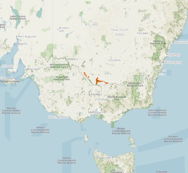
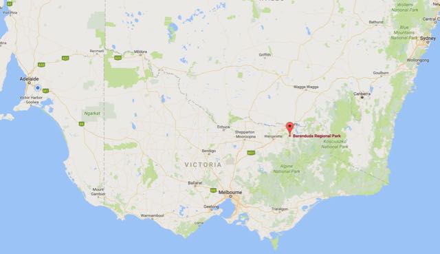
I had one planned park activation for Sunday 13th November 2016 and that was the Barmah National Park VKFF-0739, which is located about 250 km north of Melbourne.  This was to be another unique park for me as an activator for both the Keith Roget Memorial National Parks Award and the World Wide Flora Fauna (WWFF) program.

Screen Shot 2016-10-10 at 11.46.06 am.jpg

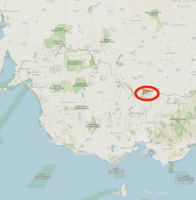
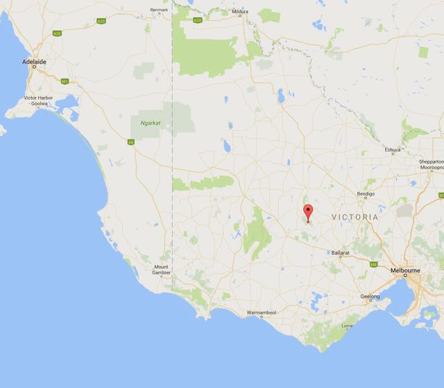
Above:- Map showing the location of the Barmah National Park in Victoria, near the New South Wales border.  Map courtesy of Protected Planet.

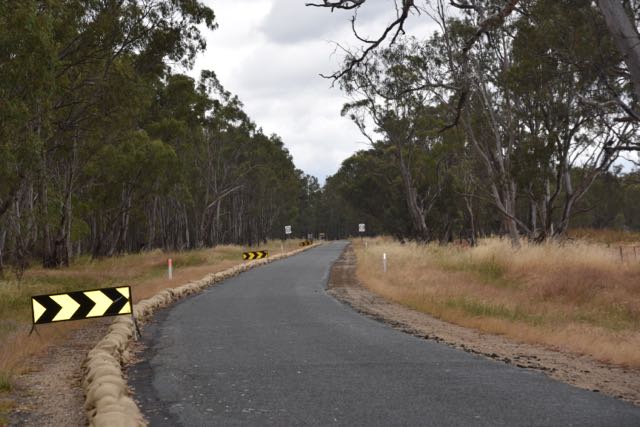
There were some concerns prior to leaving home for my VK3 trip that I may not be able to get into Barmah National Park due to the recent heavy rain and flooding.  But after speaking with Parks Victoria staff and locals in Barmah it became evident that I could get out to the park via Moira Lakes Road.  In fact on Saturday night after activating Terrick Terrick and getting back in to Barmah, I went for a drive out on Moira Lakes Road and confirmed this.

The caravan park where I was staying still had left over sandbags on its permiter from the heavy rain and floods a few weeks prior.

Moira Lakes Road is bitumen and takes you to the south western corner of the park.  The road was in good condition but there were still the tell tale signs of flooding present with the sandbags on the side of the road.  On my way out to the park I spoke with Peter VK3ZPF who was portable in the Errinundra National Park VKFF-0158.

dsc_3785

About 7 km out of Barmah I reached the entry to the Barmah National Park.  The road leading in to the park normally takes you out to Barmah Lake, howver this was blocked off due tof the flooding.

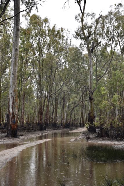
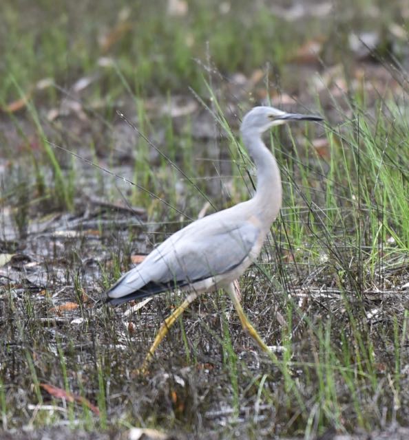
As there was still a lot of water lying around, many of the tracks in the park were closed.  However the up side was that there was a huge amount of birdlife including White Faced Herons, Spoonbills, and Egrets.

There was also an abudance of Western Grey kangaroos.  Other native wildlife in the park includes Koalas and Emus.

dsc_3840

Barmah National Park was created in April 2010 to protect and enhance the River Red Gum forets in Victoria.  It is a large park and comprises 28,521 hectares.  Together with the adjoining Murray Valley Regional and National Parks in New South Wales, Barmah forms the largest River Red Dum forest in the world.  The forest provides important habitat, particularly for waterbirds, with over 200 species of bird recorded in the park.  Barmah is one of Victoria’s largest waterbird breeding areas.

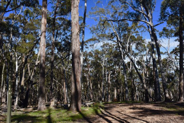
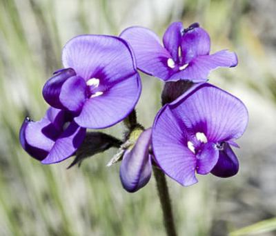
River Red Gums, some which reach 45 metres in height and are 500 years old, line the Murray River for most of its length.  Barmah protected about 38 rare or threatened plants including Fruit Saltbush and Winged Peppergrass.  Yellow and Black Box grow on the ridges.  The River Red gums require periods of flooding and can survive water inundation for months.  Their seeds are washed onto higher ground during a flood and germinate and grow before the next flood reaches them.

dsc_3803

Prior to European settlement the aboriginal Yorta Yorta people occupied this land.  Scarred trees, mounds, stone artefact scatters, middens and burial sites can be found throughout Barmah National Park.

dsc_3787

The park also has a rich European history.  The Barmah Muster yards site has been used continuosly from the 1880’s as an essential component of cattle grazing activity by local farmers in River Red Gum forests along the Murray River.  The large timber post and rail yards were designed for management of cattle grazed in the surrounding River Red Gum forests.

The Barmah Muster is an annual three day weekend event set in and around the yards at the edge of the Barmah National Park.

http://www.barmahmuster.org/

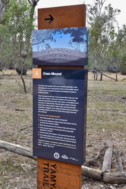
There are various interpretive signs in the park.  One that I did find was for a fallen log from a River Red Gum.  It once grew near the island lagoon in the park, but unforunately it fell down in 1999.  It is recorded in the Significant Trees section of the 1992 Barmah State Park and Barmah State Forest Management plan as ‘Assessors Pile’ with a height of 42.2 metres and a girth of 2.9 metres.  It was subsequently placed in its current position by the Dept. of Natural Resources and Environment Forests Service.

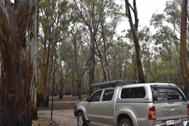
I set up alongside of the Barmah Muster yards.  It was quite a miserable morning with continual drizzle and rain and just 12 degrees C.  So despite my best attempts to operate from outside of the vehicle it was not possible.  I ended up like a drenched rat as it was whilst putting up the 80/40/20m linked dipole.  So I propped the Yaesu FT-857d on the passenger seat and ran the coax from the antenna through the passenger side window.

Screen Shot 2016-10-10 at 11.45.55 am.png

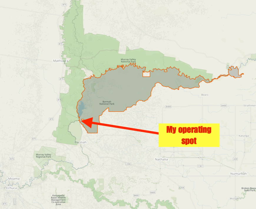
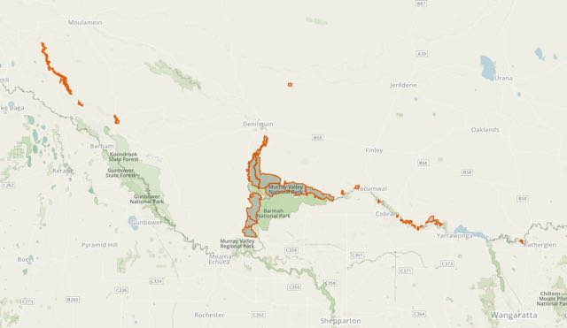
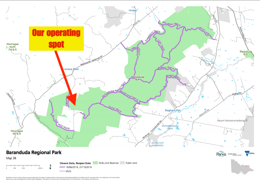
Above:- Map showing my operating spot in the south western section of the Barmah National Park.  Map courtesy of Protected Planet.

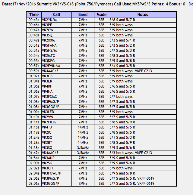
Prior to calling CQ I had a tune around the band and found Peter VK3ZPF on 7.090 operating portable from the Errinundra National Park VKFF-0158.  I logged Peter (5/9 both ways) and then headed up the band to find a clear frequency.  I commenced calling CQ on 7.110 and this was answered by Brian VK5FMID in Mount Gambier and then Les VK2FLEZ who was portable in the Wyrrabalong National Park VKFF-0550.  I went on to work a total of 44 stations on 7.110 from VK1, VK2, VK3, VK4, VK5, and VK7, thus qualifying the park for the World Wide Flora Fauna (WFF) program.  This included the following further Park to Park contacts:

  • Malcolm VK3MEL/p, Brisbane Ranges National Park VKFF-0055
  • Julie VK3SRC/p, Mornington Peninsula National Park VKFF-0333
  • Allen VK3ARH/p, Alfred National Park VKFF-0618
  • Rex VK3OF/p, Little Desert National Park VKFF-0291
  • Warren VK3BYD/p, Burrowa Pine Mountain National Park VKFF-0069
  • Gerard VK2IO/p, Seven Mile Beach National Park VKFF-0447
  • Peter VK3PF/p, Mitchell River National Park VKFF-0321 and SOTA VK3/ VG-134
  • Bernard VK3AV/p, Kinglake National Park VKFF-0264
  • Tony VK3XV/p, Lower Goulburn National Park VKFF-0741

Conditions on the 40m band were quite good, however as the morning went on, the static crashes increased in strength.

dsc_3811

When callers slowed down I took the opportunity of tuning across the band, hoping to get some more Park to Park contacts in the log.  It didn’t take long and I found Mick on 7.105 calling CQ from the Warby Ovens National Park VKFF-0742.  Mick was quite low down, 4/1, but as there was no man made noise on the band from Barmah, I was able to work Mick very comfortably with a 4/1 received from Mick.  I then found Jim VK1AT on 7.130 operating portable from the Lower Molonglo River Corridor Nature Reserve VKFF-0990, with a very strong 5/9 signal.

After speaking with Jim I headed back to 7.110 and started calling CQ again.  This was answered by Peter VK3FPSR, followed by Tom VK5NFT and then David VK5PL, all with good signals.  I worked a further 12 stations from VK2, VK3, VK5, and Vk7, including two further Park to Park contacts:

  • Johnno VK3FMPB/p, Mornington Peninsula National Park VKFF-0333
  • Tim VK3MTB/p, Morwell National Park VKFF-0626

Another interesting contact was with Dave VK2WQ who was using a home brew 2 watt double side band transceiver (5/7 both ways).

I then headed off to 20m and called CQ on 14.310 for around 5 minutes.  My only taker was Mike VK6MB who was very low down.  I was able to hear Mike but sadly he was unable to copy me.

Time was marching on, and I had hoped to activate the Murray Valley National Park in New South Wales, so I had one final tune around the 40m band before going QRT.  I found Allen VK3ARH on 7.100 who was operating portable from the Croajingolong National Park VKFF-0119 with a nice strong 58 signal.  As I was signing with Allen, Paul VK3ZT called, and Allen kindly allowed me to log Paul before I hit the switch from Barmah.

So despite the rather dismal weather I had enjoyed my visit to Barmah and the activation.  I had a total of 64 contacts in the log, including 16 Park to Park contacts.

The following stations were worked on 40m SSB:-

  1. VK3ZPF/p (Errinundra National Park VKFF-0158)
  2. VK5FMID (Wyrrabalong National Park VKFF-0550)
  3. VK2FLEZ/p
  4. VK5BJE
  5. VK5GJ
  6. VK3MEL/p (Brisbane Ranges National Park VKFF-0055)
  7. VK3PMG/m
  8. VK3GGG/m
  9. VK3SRC/p (Mornington Peninsula National Park VKFF-0333)
  10. VK1AD
  11. VK5WG
  12. VK5JK
  13. VK3SQ
  14. VK4RF
  15. VK4HA
  16. VK1DI
  17. VK2XXM
  18. VK3ELH
  19. VK3ARH/p (Alfred National Park VKFF-0618)
  20. VK5FAKV
  21. VK5KLV
  22. VK3OF/p (Little Desert National Park VKFF-0291)
  23. VK3BYD/p (Burrowa Pine Mountain National Park VKFF-0069)
  24. VK2VW
  25. VK2YK
  26. VK2IO/p (Seven Mile Beach National Park VKFF-0447)
  27. VK3PF/p (Mitchell River National Park VKFF-0321 and SOTA VK3/ VG-134)
  28. VK5FANA
  29. VK5HOS
  30. VK5FFAB
  31. VK5AAR
  32. VK3SFG
  33. VK3AV/p (Kinglake National Park VKFF-0264)
  34. VK5MBD
  35. VK5TW
  36. VK5NAQ
  37. VK5RM
  38. VK3XV/p (Lower Goulburn National Park VKFF-0741)
  39. VK7KJL
  40. VK2FOUZ
  41. VK7JON
  42. VK2STO
  43. VK7FMPR
  44. VK2MTC
  45. VK3PMG/p (Warby Ovens National Park VKFF-0742)
  46. VK3GGG/p (Warby Ovens National Park VKFF-0742)
  47. VK1AT/p
  48. VK3FPSR
  49. VK5NFT
  50. VK5PL
  51. VK7FRJG
  52. VK2SK
  53. VK3QB
  54. VK7DW
  55. VK2ALF/p
  56. VK2FPRM
  57. VK2VU
  58. VK5JP
  59. VK3FMPB/p (Mornington Peninsula National Park VKFF-0333)
  60. VK2FSVN
  61. VK2WQ
  62. VK3MTB/p (Morwell National Park VKFF-0626)
  63. VK3ARH/p (Croajingolong National Park VKFF-0119)
  64. VK3ZT


References.

Parks Victoria, 2014, ‘Barmah National Park Visitor Guide’.
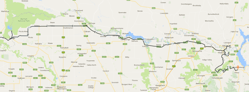