Nixon Skinner Conservation Park, VKFF-0923

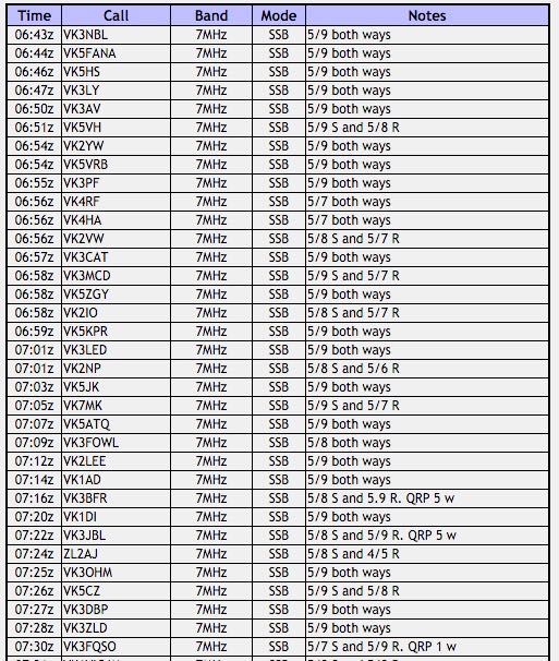
My second park activation for Sunday 30th November 2015, and my final activation for the inaugural 2015 VKFF Activation Weekend, was the Nixon Skinner Conservation Park, VKFF-0923.  The park is located on the Fleurieu Peninsula, about 5 km south of Myponga, and about 60 km south of Adelaide

Screenshot 2015-12-13 17.19.13

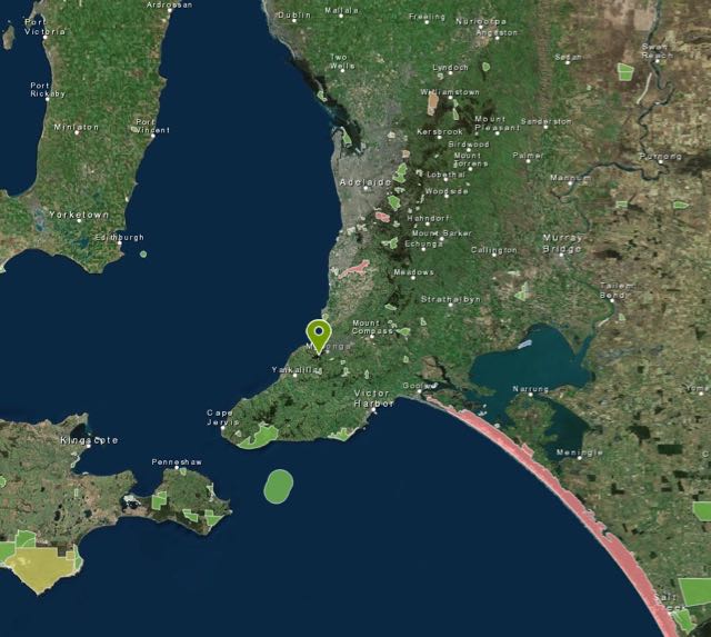
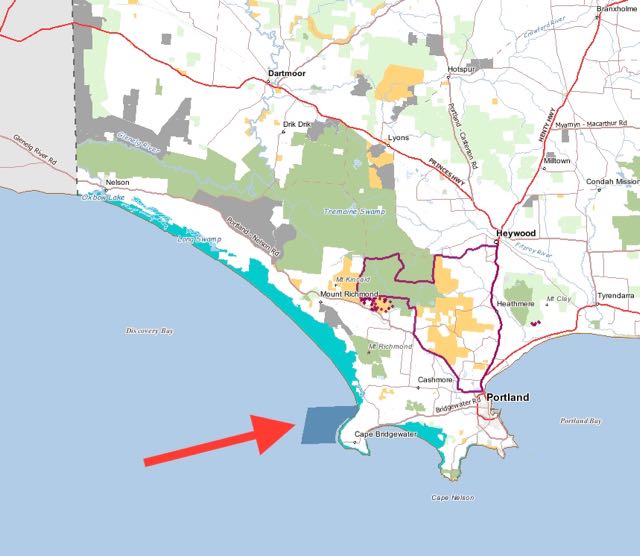
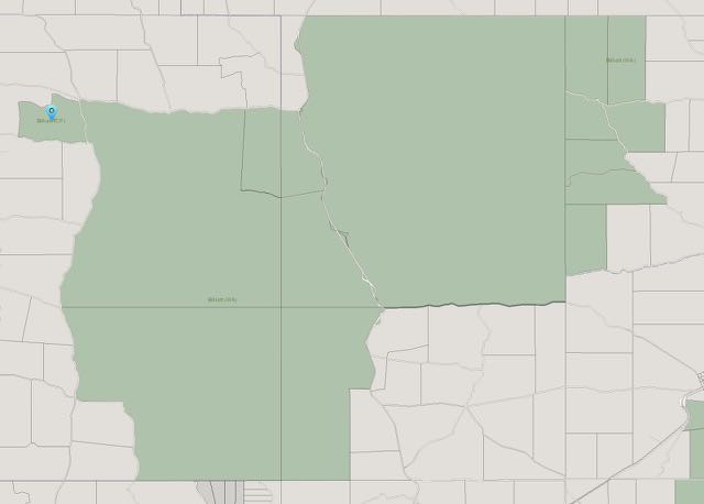
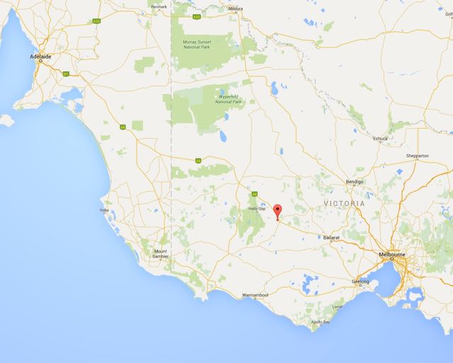
Above:- Map showing the location of the Nixon Skinner Conservation Park.  Image courtesy of Location SA Map Viewer.

I had activated Nixon Skinner Conservation Park previously, back in October, 2013, but as per all of my activations for the VKFF weekend, this activation was prior to the park being added to the VKFF list for the World Wide Flora and Fauna (WWFF) program.

For more information on my previous activation, please see…..

https://vk5pas.org/2013/10/14/nixon-skinner-conservation-park/

After leaving Stipiturus Conservation Park, I travelled west along Pages Flat Road, until I reached the little town of Myponga which is the hub of lush grazing and dairy country.  The name derived from the Aboriginal word ‘maippunga’ meaning locality of high cliffs.  Myponga was the venue for the first Australian performance by leading British heavy rock group Black Sabbath during the Myponga Music festival in 1971.  Prior to this festival the town’s leading claim to fame was the 1953 discovery of a uranium ore deposit at Wild Dog Hill.  Myponga is also the home of the Smiling Samoyed Brewery which is a small unique brewery and the Myponga market which is located in the old cheese factory.

I then travelled south west along Main South Road for around 5 kms.  I knew where I was heading as I had activated the park before.  But if you haven’t been to Nixon Skinner previously, then don’t blink.  You will probably miss it.   Just as you pass Causeway Road and travel over a part of the Myponga Reservoir, you will see a small track off to your right.  This is where you access the park.

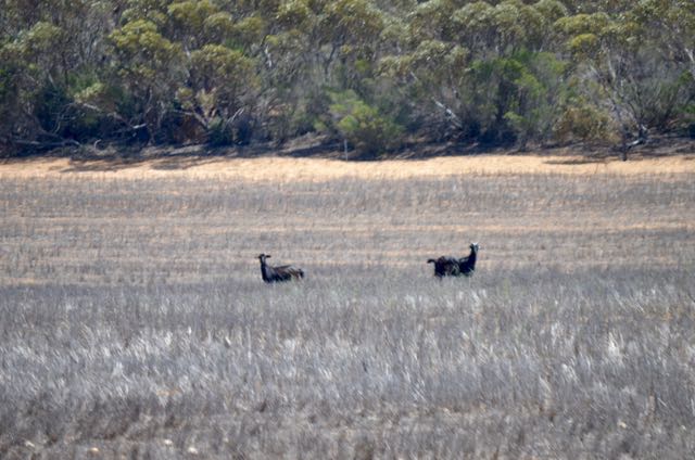
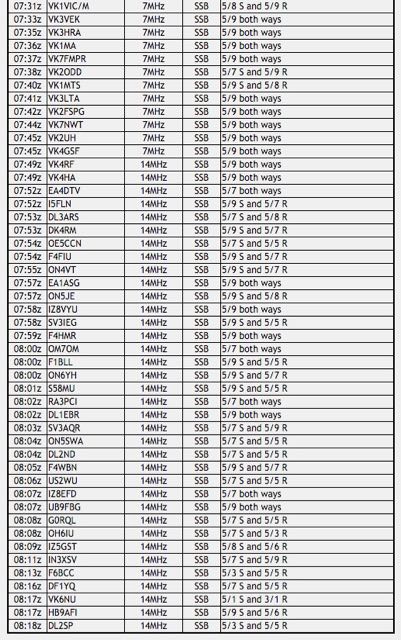
There is a locked gate at this location.  Sadly, this is another locked Conservation Park.  But there is a gap in between the fence and the gate, allowing pedestrians into the park.  There is a bitumen road here and some old fire ban signs, so clearly at one stage, you could drive a vehicle down to the waterfront of the Myponga Reservoir.  If you have time I would highly recommend the walk down to the water.  It is a scenic walk and you will be rewarded with some great views of the reservoir.  And depending upon what time of the day you are here, the area is alive with kangaroos.

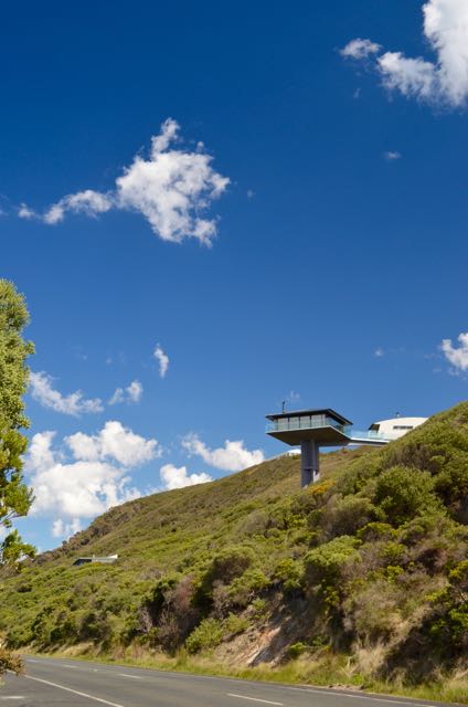
Nixon Skinner is only a small park.  It comprises 8 hectares of native vegetation, and backs on to the south western side of the Myponga Reservoir which provides about 5% of the drinking water for Adelaide.  It is the main source of filtered water for southern metropolitan Adelaide and the southern coast area.

This slideshow requires JavaScript.

In 1956 Mrs. Lucy Eleanor Page, a long standing and active member of the Field Naturalists Society of South Australia, donated the land.  The park was named in honour of her grandfathers and was the first privately donated reserve to be established in South Australia for the preservation in perpetuity of native plants and animals and for the enjoyment of nature lovers.  There is a memorial plaque for Mrs. Page, but keep your eye out for it.  I doubt that a DEWNR official has been in the park for a long time, as the plaque is underneath a tree and severely overgrown.

I set up in the same spot I had set up previously, just along the road inside the gate.  For this activation I used the Yaesu FT-857d, 40 watts and the 40m/20m linked dipole, supported on the 7 metre squid pole.  I supported the squid pole with the squid pole holder and an octopus strap.  It was hard going driving the holder into the ground, as it was very very dry.  Next time I think I will walk a lot further down the track, as Main South Road which passed by the park was extremely noisy and busy with tourist traffic travelling to and from the seaside tourist towns on the Fleurieu Peninsula, and Adelaide.

Screenshot 2015-12-13 17.19.45.jpg

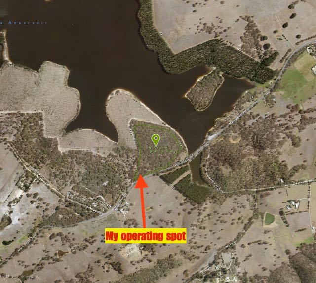
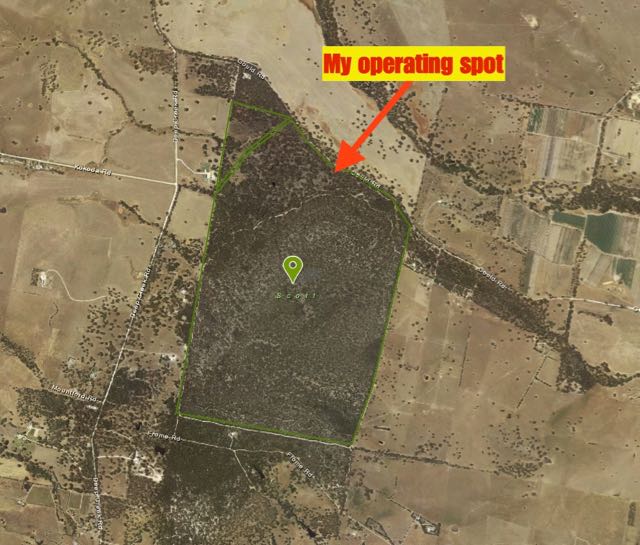
Above:- Map showing my operating spot in the south western corner of the park.  Image courtesy of Location SA Map Viewer.

The start of this activation was a park to park fest.  I decided to have a tune around the 40m band before calling CQ.  And as a result I worked 7 park activators to start off the activation.

  • VK3TST/2 (Livingstone National Park VKFF-0292)
  • VK5EE/p (Ewens Ponds Conservation Park VKFF-0796)
  • VK3TKK/p (Lerderberg State Park VKFF-0763)
  • VK4AAC/5 (Beachport Conservation Park VKFF-0791)
  • VK1DI/p (Molonglo Gorge Nature Reserve VKFF-0901)
  • VK5FANA/p (Clinton Conservation Park VKFF-0813)
  • VK5HSX/2 (Murrumbidgee Valley National Park VKFF-0554)

I then headed for 7.155 and started calling CQ.  It wasn’t long before I had a mini pile up going, with the first caller being Allen VK3HRA, followed by Fred VK3DAC and then Tony VK5FTVR.  Soon after I had a call from Peter VK3PF who was portable in the Port Phillip Heads Marine National Park VKFF-0954.  This was a brand new park for me as a Hunter.  Next up was Andrew VK1DA/2 who was activating SOTA peak, Mount Bowning, VK2/ ST-042., north west of Yass.  And soon after Gary VK5FGRY called in again from the Morialta Conservation Park, along with Gerard VK2IO who was activating the Cattai National Park VKFF-0092.

When things slowed down a little, I had a glance around the 40m band again with the hope of picking up some more park activators, and that I did:

  • VK1VIC/p (Colleman Ridge Nature Reserve VKFF-0837)
  • VK5ZGY/p (Penola Conservation Park VKFF-0803)
  • VK5FFCC/p (Deep Creek Conservation Park VKFF-0780)
  • VK3YY/p (SOTA VK3/ VC-031 and VKFF-0750)
  • VK3VTH/p (Bendigo Regional Park VKFF-0960)

I then started calling CQ on 7.144 and worked a number of the regular park hunters, from VK2, VK3, VK5, and VK7, all of whom had good signals.  The band was working well.  The kookaburra sounded on my i-phone to alert me of Col VK5HCF and Tom VK5EE on 7.130 from the Douglas Point Conservation Park, VKFF-0795, so that’s where I headed for another park to park contact.

I then tried 20m briefly, but there were not a lot of takers there, with just 4 stations logged from VK2 and VK4.  So it was off to 15m where I enjoyed a little more success.  I worked a total of 10 stations on 15m from VK3, VK4, and Japan.

I then returned to 40m and worked Peter VK3PF who was now activating the Point Nepean National Park, VKFF-0628, before I propped on 7.120 and called CQ.  I worked a number of the regular park hunters and also picked up another park to park contact.  This time with David VK5PL who was activating the Kaiser Stuhl Conservation Park, VKFF-0897 in the Barrossa Valley.

I again tuned around the band and picked up some more park to park contacts:

  • VK5LOL/p (Onkaparinga River National Park VKFF-0402)
  • VK5PET/p (Coorong National Park VKFF-0115)
  • VK5AKH/p (Onkaparinga River National Park VKFF-0402)

I then commenced calling CQ on 7.115 and worked into VK2, VK3, VK5, and VK6.  This included a park to park contact with Lewis VK6FLEW who was operating portable from the Yanchep National Park, VKFF-0553.  The static crashes had really picked up and it was a very difficult contact.  But due to the perseverance of us both, we eventually made it, exchanging signal reports and park numbers (3/3 sent and 3/1 received).  Well done Lewis, it was great to get you in the log.

I tried 20m and 15m one last time each.  On 20m I worked into Italy, VK5 and VK6.  But it was so noisy on 20m with extremely loud static crashes, that I decided it just wasn’t worth continuing, and trying to get Europe on the long path.  On 15m I worked just 3 stations in Japan and VK3.

This was a great afternoon in the park with a total of 102 contacts on 40m, 20m, and 15m.  This included a total of 24 park to park QSOs.

The following stations were worked on 40m SSB:-

  1. VK3TST/2 (Livingstone National Park VKFF-0292)
  2. VK5EE/p (Ewens Ponds Conservation Park VKFF-0796)
  3. VK3TKK/p (Lerderberg State Park VKFF-0763)
  4. VK4AAC/5 (Beachport Conservation Park VKFF-0791)
  5. VK1DI/p (Molonglo Gorge Nature Reserve VKFF-0901)
  6. VK5FANA/p (Clinton Conservation Park VKFF-0813)
  7. VK5HSX/2 (Murrumbidgee Valley National Park VKFF-0554)
  8. VK3HRA
  9. VK3DAC
  10. VK5FTVR
  11. VK3OHM
  12. VK5FMID
  13. VK3PF/p (Port Phillip Heads Marine National Park VKFF-0954)
  14. VK1DA/p (SOTA VK2/ ST-042)
  15. VK3PMG
  16. VK3YAR
  17. VK5JK
  18. VK5FGRY/p (Morialta Conservation Park VKFF-0783)
  19. VK1MA
  20. VK5HS
  21. VK5FLEX
  22. VK2IO/p (Cattai National Park VKFF-0092)
  23. VK1VIC/p (Cooleman Ridge Nature Reserve VKFF-0837)
  24. VK5ZGY/p (Penola Conservation Park VKFF-0803)
  25. VK5FFCC/p (Deep Creek Conservation Park VKFF-0780)
  26. VK5TR
  27. VK3YY/p (SOTA VK3/ VC-031 and VKFF-0750)
  28. VK3VTH/p (Bendigo Regional Park VKFF-0960)
  29. VK5DJ
  30. VK5PL
  31. VK2AWJ
  32. VK2VW
  33. VK7CW
  34. VK2NEO
  35. VK2QR
  36. VK2HEW
  37. VK5GJ
  38. VK3FLCS
  39. VK3TKK/m
  40. VK5WG
  41. VK5KLV
  42. VK5AV
  43. VK5EE/p (Douglas Point Conservation Park VKFF-0795)
  44. VK5HCF/p (Douglas Point Conservation Park VKFF-0795)
  45. VK3PF/p (Point Nepean National Park VKFF-0628)
  46. VK5NFT
  47. VK5FD
  48. VK5MBD
  49. VK3FPAR
  50. VK5HYZ
  51. VK3BSG
  52. VK5NRG
  53. VK3DBP
  54. VK5PL/p (Kaiser Stuhl Conservation Park VKFF-0897)
  55. VK3ANL
  56. VK3ZD
  57. VK7FRKL
  58. VK3OF
  59. VK5LOL/p (Onkaparinga River National Park VKFF-0402)
  60. VK5PET/p (Coorong National Park VKFF-0115)
  61. VK5AKH/p (Onkaparinga River National Park VKFF-0402)
  62. VK5NIG
  63. VK3FIRM
  64. VK3UH
  65. VK3FPBI
  66. VK5AW/m
  67. VK5VBR
  68. VK5FANA
  69. VK2PKT
  70. VK3UT
  71. VK6FLEW/p (Yanchep National Park VKFF-0553)
  72. VK3BQ
  73. VK5FDEC
  74. VK3ETC
  75. VK3VEF
  76. VK5HEL
  77. VK5NJ
  78. VK5MCB

The following stations were worked on 20m SSB:-

  1. VK2YW
  2. VK4RF
  3. VK4HA
  4. VK2HOT
  5. VK6NU/p (Wandoo National Park VKFF-0656)
  6. VK5KBJ
  7. VK6DW
  8. VK4QQ
  9. IK1GPG
  10. VK6XL
  11. VK6HAO

The following stations were worked on 15m SSB:-

  1. VK4RF
  2. VK4HA
  3. JA8RJE
  4. VK4FFAB
  5. VK3FAPH
  6. JK1THF
  7. VK3PMM
  8. VK3MEG
  9. JE1GWO
  10. JA1SMM
  11. JA4SCQ
  12. VK3FIRM
  13. VK3FONZ


Scott Conservation Park, VKFF-0934

My second park for Saturday 29th November 2015 was the Scott Conservation Park, VKFF-0934, which is situated north west of Currency Creek on the Fleurieu Peninsula.  It is about 75 km south of Adelaide.

Screenshot 2015-12-12 21.46.58

Above:- Map showing the location of Scott Conservation Park.  Image courtesy of Location SA Map Viewer.

This was another park that I had activated previously as part of the VK5 National & Conservation Parks Award, but prior to it being added to the World Wide Flora Fauna (WWFF) program.  For more information on my previous activation back in December 2013, please see my previous post at…..

https://vk5pas.org/2013/12/27/scott-conservation-park/

After leaving Mount Magnificent I travelled along the Enterprise Road and then turned left onto Nangkita Road, passing through the little town of Nagkita.  I then turned right onto Deep Creek Road and then left onto Gould Road.  There is a sign for the park at this intersection.

DSC_0454

Scott Conservation Park is about 210 hectares in size.  It consists of Blue and Pink gum woodlands.  The scrub here is very thick.  That is compared to the cleared land on each side of the park.  The park is home to a large amount of native wildlife including Western Grey Kangaroos, Ringtail Possums and Western Pygmy-possums.  A number of endangered birds are also located in the park including the Chestnut-rumped Heathwren and the Diamond Firetail finch.

There is a small carpark on Gould Road on the northern side of the park.  This appears to be the only way to access the park, as it appears that private land is situated on the western, eastern and southern side of the park.  I parked the 4WD and walked a short distance down a fire access track.  There is a locked gate so you cannot drive down the track.

Screenshot 2015-12-12 21.46.21

Above:- Map showing my operating spot in the northern section of the park.  Image courtesy of Location SA Map Viewer.

I set up my fold up table and deck chair, and the Yaesu FT-857d, and my 20m/40m linked dipole.  I was a little behind schedule but was up and ready to go by 0235 UTC (11.05 a.m. South Australian local time).  I had the transceiver on 14.310 when I turned it on and heard Gerard VK2IO calling CQ from a park.  But I still had not erected the 7 metre telescopic squid pole.  So I quickly put it in place and tied the ends of the dipole to some nearby trees, hoping to get Gerard before he left the frequency.  Unfortunately I wasn’t quick enough.  I gave Gerard a call, but he had gone.

So I headed for 40m and started calling CQ on 7.145.  My first taker there was Stef VK5HSX who was portable in the Murray Sunset National Park, VKFF-0373.  Stef had a very strong 5/9 signal coming in from western Victoria.  My next caller was park regular Rex VK3OF, followed by another park stalwart Peter VK3TKK.  My fourth contact was with Greg VK5ZGY in the Nene Valley Conservation Park, VKFF-0801.

The 40m band was in good shape, with strong signals coming in from VK2, VK3, and VK5.  It wasn’t long before I had a number of other park contacts in the log.  They included:-

  • Gerard VK2IO in the Sydney Harbour National Park, VKFF-0473
  • Cliff VK2NP in the Sea Acres National Park, VKFF-0606
  • Ian VK1DI in the Goorooyaroo Nature Reserve VKFF-0841
  • Greg VK5GJ in the Kyeema Conservation Park VKFF-0826
  • Rob VK4AAC/5 in the Little Dip Conservation Park VKFF-0904
  • Les VK5KLV in the Whyalla Conservation Park, VKFF-0808
  • Pat VK5HAE in the Whyalla Conservation Park, VKFF-0808
  • Adrian VK5FANA in the Bird Islands Conservation Park, VKFF-0871
  • Tony VK3VTH in the Cobram Regional Park, VKFF-0961
  • Amanda VK3FQSO in the Kooyoora State Park VKFF-0729
  • Allen VK3HRA in the Hepburn Regional Park, VKFF-0968

I also had some good QRP contacts.  These included Ian VK5CZ running 5 watts from the Clare Valley (5/9 both ways), and Tom VK5NFT, also running 5 watts from Millicent in the South East (5/7 sent and 5/9 received).  Mal VK5MJ also called in from his boat on the Murray River near Lyrup, in the Riverland region of South Australia.

When things got a little quiet, I had a listen around the band and found Compton VK2HRX on SOTA peak, Mount Canobolas VK2/ CT-001, south west of Orange in New South Wales.  Although Compton was quite weak, we managed a contact (4/1 both ways).

I then returned back higher up the band to 7.144 and called CQ again.  This time my CQ call was answered by Peter VK5APR operating from the Adelaide Hills Amateur Radio shack at Blackwood.  Again it wasn’t long before I had some more park to park contacts in the log.  This time they were:-

  • Tom VK5EE in the Penambol Conservation Park, VKFF-0802
  • Greg VK5ZGY in the Canunda National Park, VKFF-0075
  • Col VK5HCF in the Penambol Conservation Park, VKFF-0802
  • Gary VK5FGRY in the Morialta Conservation Park, VKFF-0783

When things slowed down again I seized the opportunity of looking across the band and I soon found Peter VK3ZPF on 7.090 calling CQ from the Point Nepean National Park, VKFF-0628 (5/9 both ways).  Next up was Mick VK3PMG on 7.120 calling CQ from the Gunbower National Park, VKFF-0740 (5/8 both ways).

I then headed off to 20m and started calling CQ on 14.310.  This was answered by Brett VK2VW with a very strong 5/9 signal.  And guess who was next.  Yes, the ever  reliable and ever so keen, Rick VK4RF/VK4HA. who was also 5/9.  I worked a further 4 stations on 20m, making my total contacts 49.

It was then back to 40m briefly to work Ray VK3YAR on a SOTA peak, Mount Bealiba VK3/ VN-026, and then I tried my luck on 15m.  It was down with the 20m/40m linked dipole, which I didn’t pack away, but rather, layed on the ground.  And up with the 15m dipole.  I called CQ on 21.244 and again, my first taker was Brett VK2VW with a good 5/7 signal (5/5 received).  And next, much to my surprise, was Rob VK4FFAB portable in the Geham National Park VKFF-0679 with a good 5/4 signal (5/5 received).  Rob had been encouraging me to use 15m a bit more often, so it was a pleasure to get him in the log.  I worked a further 5 stations on 15m, from VK2, VK4, and Vk6.  This included Gerald VK2HBG in the Bimberamala National Park VKFF-0032.

I then packed away the 15m dipole and re-erected the linked dipole and worked Tony VK3VTH on 14.310, who was portable in the Cobram Regional Park VKFF-0961.

I was pushing it a bit for time, so I went back to 40m for a short period and spoke with Giles VK5GK in the Mount George Conservation Park, VKFF-0784.  This was Giles first ever park activation, so it was a pleasure to speak with Giles.  I then worked Ian VK5CZ in the Spring Gully Conservation Park, VKFF-0816, and then Greg VK5GJ in the Cox Scrub Conservation Park, VKFF-0824.

I decided to call CQ one last time on 7.135 and Joe VK3YSP responded.  Joe was operating portable from the Dromana Pier with his wife Julie VK3YSP.  My final contact was with Keith VK2PKT, who has recently become a regular park hunter.

So after about 2 and 1/2 hours in the park I had a total of 66 contacts in the log, including another 26 park to park contacts.  This was another great activation, which was watched on by the little fella below, a Shingleback lizard, who was sunning himself only a few metres away from where I was operating.  Fortunately I did not see any snakes.

DSC_0466.jpg

The following stations were worked on 40m SSB:-

  1. VK5HSX/p (Murray Sunset National Park VKFF-0373)
  2. VK3OF
  3. VK3TKK
  4. VK5ZGY/p (Nene Valley Conservation Park VKFF-0801)
  5. VK5ZTS
  6. VK5CZ
  7. VK5HYZ
  8. VK5QI/m
  9. VK3NBV
  10. VK5FMID
  11. VK5KX
  12. VK2IO/p (Sydney Harbour National Park VKFF-0473)
  13. VK5FO/m
  14. VK2NP/p (Sea Acres National Park VKFF-0606)
  15. VK1DI/p (Goorooyaroo Nature Reserve VKFF-0841)
  16. VK3PMG/m
  17. VK5GJ/p (Kyeema Conservation Park VKFF-0826)
  18. VK4AAC/5 (Little Dip Conservation Park, VKFF-0904)
  19. VK5KLV/p (Whyalla Conservation Park VKFF-0808)
  20. Pat VK5HAE/p (Whyalla Conservation Park VKFF-0808)
  21. VK5FANA/p (Bird Islands Conservation Park VKFF-0871)
  22. VK5BW
  23. VK3VTH/p (Cobram Regional Park VKFF-0961)
  24. VK3FQSO/p (Kooyoora State Park VKFF-0729)
  25. VK3HRA/p (Hepburn Regional Park VKFF-0968)
  26. VK5AVQ
  27. VK5MJ/mm
  28. VK3DBP
  29. VK5NFT
  30. VK5AV
  31. VK5PL
  32. VK5TR
  33. VK2HRX/p (SOTA VK2/ CT-001)
  34. VK5APR
  35. VK3AKK
  36. VK5EE/p (Penambol Conservation Park VKFF-0802)
  37. VK5ZGY/p (Canunda National Park VKFF-0075)
  38. VK5HCF/p (Penambol Conservation Park VKFF-0802)
  39. VK5MRE
  40. VK5FGRY/p (Morialta Conservation Park VKFF-0783)
  41. VK3PF
  42. VK3ZPF/p (Point Nepean National Park VKFF-0628)
  43. VK3PMG/p (Gunbower National Park VKFF-0740)
  44. VK3YAR/p (SOTA VK3/ VN-026)
  45. VK5GK/p (Mount George Conservation Park VKFF-0784)
  46. VK5CZ/p (Spring Gully Conservation Park VKFF-0816)
  47. VK5GJ/p (Cox Scrub Conservation Park VKFF-0824)
  48. VK3YSP/p
  49. VK3FOWL/p
  50. VK2PKT

The following stations were worked on 20m SSB:-

  1. VK2VW
  2. VK4RF
  3. VK4HA
  4. VK7CW
  5. VK2UH
  6. VK3PAT
  7. VK3HMV
  8. VK3VTH/p (Cobram Regional Park VKFF-0961)

The following stations were worked on 15m SSB:-

  1. VK2VW
  2. VK4FFAB/p (Geham National Park VKFF-0679)
  3. VK4RF
  4. VK4HA
  5. VK2PH
  6. VK2HBG/p (Bimberamala National Park VKFF-0032)
  7. VK4ZD
  8. VK6MJP

One Tree Hill, VK3/ VS-036

Our final activation for Wednesday 18th November 2015, was One Tree Hill, VK3/ VS-036, which is located just to the north west of Ararat in western Victoria.

I have activated this summit once before, back in September 2013.  For more information on that activation, please have a look at my previous post…..

https://vk5pas.org/2013/09/13/one-tree-hill-vk3-vs-036/

Screenshot 2015-12-11 15.05.03

Above:- Map showing the location of One Tree Hill.  Image courtesy of google maps.

One Tree Hill is 569 metres above sea level and is worth 2 SOTA points.  It is a very easy summit to access.  After leaving the motel room we drove up Golf Links Road and then Picnic Road.  We then took One Tree Hill Road, which takes you up to the Ararat Regional Park entrance.  This park is made up of three separate blocks.  This is the Ararat Hills block which is 820 hectares in size.  The other two sections of the park are Dunneworthy block (2,670 hectares) and Bradys block (180 hectares).

DSC_0270

Continue along this bitumen road and it will take you to the One Tree Hill lookout.  This is not the summit though.  At the end of the bitumen and the carpark, there is a narrow dirt track.  You need to head down this track to get to the summit.  This track is definitely not suitable for a conventional vehicle.  So if you have your car, leave it in the carpark, and walk the remainder of the way to the summit.  It’s not that far and is not an onerous walk.

Screenshot 2015-12-11 15.04.47

Above:- Aerial shot showing the location of the summit, to the north west of Ararat.  Image courtesy of google maps.

We stopped briefly in the carpark and took some photographs of Ararat and the surrounding countryside.  There are some great views from here of the nearby Grampian Mountains, Mount Langi Ghiran, and Mount Cole.

This slideshow requires JavaScript.

As we had the Toyota HiLux we drove along the track for a few hundred metres until we found a clearing off the dirt track.  We parked the 4WD there, and then walked a short distance to another clearing and set up our gear there.

Screenshot 2015-12-11 15.04.21Above:- Aerial shot showing the location of the summit, further to the north of the lookout.  Image courtesy of google maps.

The summit is quite heavily wooden with gum trees, so I’m really not sure why it is called One Tree Hill.

DSC_0285

I commenced calling CQ on 7.088.  I could not get onto my nominated operating frequency of 7.090 as the Kandos Net was running on 7.093.  It didn’t take long for the SOTA chasers to be queuing up to get in the log.  My first contact was with Ray VK3NBL, followed by Adrian VK5FANA, Ivan VK5HS, and then Bill VK3LY.  I was kept busy with a mini pile up with callers from VK1, VK2, VK3, VK4, VK5, and VK7.  The 40m band was in very good condition with excellent signal reports both ways.

I was pleased to be able to work Warren ZL2AJ, the New Zealand SOTA Association Manager.  Warren had a strong 5/8 signal to One Tree Hill from near Palmerston North on the North Island.  I also had some great QRP contacts.  They included Ian VK3BFR running 5 watts (5/8 sent and 5/9 received), and Andrew VK3JBL running 5 watts (5/8 sent and 5/9 received).

I worked a total of 46 stations on 40m before heading to 20m.  I commenced calling CQ on 14.311 and this was answered by Rick VK4RF/VK4HA with a very strong 5/9 signal.  This was followed by EA4DTV in Spain, Luciano I5FLN in Italy, and then Rudi DL3ARS in Germany.  Signals on the long path from Europe were very good.  Early on during my 20m stint, John VK6NU called in a number of times from Western Australia, but unfortunately he was not able to hear me.  But we did make it some 30 minutes later, albeit a little difficult.  I went on to work a total of 36 stations on 20m in VK4, Spain, Italy, Germany, Austria, France, Belgium Greece, Slovak Republic, Russia, Ukraine, England, and Switzerland.

After about 90 minutes on One Tree Hill I had a total of 82 contacts in the log.

The following stations were worked:-

Screenshot 2015-12-11 14.59.07 Screenshot 2015-12-11 14.59.15

Below is the sunset out to the west as we were leaving the summit.

DSC_0286

We headed back in to Ararat and went to one of the local hotels only to be told that they did not serve meals on a Wednesday night.  So we headed down to Sicilians Restaurant and I am very pleased we did.  The service was excellent, and the meal was superb.  My meal was so big, I couldn’t finish it, and we needed to take some of it home in a ‘doggie bag’.


References.

Parks Victoria, 2015, <http://parkweb.vic.gov.au/explore/parks/ararat-hills-r.p.&gt;, viewed 10th December 2015


Point Addis Marine National Park, VKFF-0952

Tuesday, the 17th November 20165, was day 11 of our trip away.  We had spent a quiet Monday night in the apartment, and all of this day was a planned tourist day.  So we had a little bit of a sleep in, but the quiet of the morning soon changed with the arrival of some Sulphur Crested cockatoos on our doorstep.  They were very tame and allowed us to hand feed them.  It wasn’t long before the magpies had joined in the party.

After breakfast we drove in to Lorne and had a quick look around.  This included a visit to Lorne’s historic swing bridge which spans the mouth of the Erskine River.  The bridge was constructed in 1937.  We also took a walk along Lorne’s main street on the foreshore.

We drove up to have a look at the very majestic, Grand Pacific Hotel in Lorne, which can be located at the top end of Mountjoy Parade.  Whilst there we booked a table for a meal that evening.  The Grand Pacific was built in 1875 and features superb ocean views.

Marija was very keen to travel to Torquay, about 47 km north west of Lorne.  So that is where we headed.  We stopped a number of times along the way to enjoy the amazing views of the coastline along the Great Ocean Road.  Along the way I booked in to the morning net on 40m run by Ron VK3MRH, who himself has recently become a very avid park hunter.

No trip along the Great Ocean Road is complete until you have stopped at the Memorial Arch.  So of course, that’s what we did.  Along when 10,000 other tourists.  Well, okay, that might be a slight exaggeration.  But there were certainly a lot of tourists here.

The Memorial Arch is a tribute to the World War One servicemen who constructed the Great Ocean Road.  The current day arch is the third to be built.  It replaced the second arch which was destroyed in the February 1983 Ash Wednesday bushfires.  The arch consists of a timber log archway with cement and stone supports on each side.

The Great Ocean Road was completed in 1932 and the arch was first erected in 1939.  It was replaced in 1973 and again in 1983.  There are a number of plaques here which tell all about the story of the construction of the Great Ocean Road.

This slideshow requires JavaScript.

There were also some very impressive homes along the Great Ocean Road.  I gazed at a number of them in awe as we passed them, including the one below.  What great views.  And even better, from an amateur radio operator point of view….what a great take off!

DSC_0087

We drove into the beautiful little town of Aireys Inlet, about 19 km north west of Lorne.  Aireys Inlet is a lovely little coastal town, and has a population of around 1,200 people.  The town was devastated during the 1983 Ash Wednesday bushfires, with a large number of homes completely destroyed.  The area experienced a brief lull, but interest in the area soon resumed and has been steadily increasing ever since.

We stopped briefly to have a look at the bark hut in Aireys Inlet.  In 1852, Geelong butchers, Thomas Pearse and Robert McConachy, purchased the Anglohawk cattle station which ran from the Aireys inlet side of Painkalac Creek back towards Anglesea.  Initially they built a slab house, a stone shed and 2 bark huts near there.  The bark hut in Aireys Inlet is a replica of one of the hunts, which survived until 1983, when it was destroyed by bushfire.

We then stopped off at the Split Point lighthouse at Aireys Inlet.  Construction on the lighthouse commenced in late 1890 and the lighthouse was first illuminated in September 1891.  Prior to this, there were about ten shipwrecks along the surrounding coastline.  It was these tragedies that prompted authorities to plan the lighthouse.  Originally called Eagles Nest Point, the lighthouse was renamed Split Point in 1913.

The lighthouse has featured on series 6 of Masterchef.  There is a cairn here which marks the burial site of Thomas Pearsse (mentioned above) and his wife, Martha.

For more information on the lighthouse, have a look at……

http://splitpointlighthouse.com.au/

We continued along the Great Ocean Road towards Torquay, stopping briefly to enjoy the view at Urquart Bluff.  We then drove down to the beach and had lunch, whilst sitting back enjoying the magnificent views and the sensational sunshine.

DSC_0108


After lunch we drove on to the little town of Anglesea and stopped at the Anglesea Lookout Reserve which is also known as Loveridge Lookout.  The lookout was built in 1938 as a memorial to James Loveridge by his widow Bertha.  It is located near the former Loveridge owned property, ‘Anglecrest’.  This site was chosen by Bertha, as it was James Loveridge’s favourite viewing location of Bass Strait.  Sadly, the Ash Wednesday bushfires were to take another victim, with the destruction of the original ‘Anglecrest’ homestead.  During the Second World War, Loveridge Lookout was used as an observation post for the Volunteer Air Observers Corps.

We continued on to Torquay, which is just 21 km from Geelong.  This popular tourist town is the gateway to the Great Ocean Road from Melbourne.  Torquay’s population is around 10,200 people.

Torquay is famous for its surf beaches, with Jan Juc and the world famous Bells Beach located on the town’s south-west outskirts.  As a result, there is a major complex in the town which features a number of surf shops.

It was a warm afternoon, so Marija and I took the time out to stop off at one of the cafes in Torquay and enjoy a smoothie each.  It was whilst we were sitting back relaxing, that I was going through some of the tourist brochures and learnt that we would be passing the Point Addis Marine National Park on the way back to Lorne.  A little bit of groveling to Marija, and it was agreed upon that I could do a quick activation of the park.

DSC_0124.jpg

The park was just a 14 km drive from Torquay.

Screenshot 2015-12-10 17.23.32

Above:- Map showing the location of the Point Addis Marine National Park.  Image courtesy of Forest Explorer.

We then headed back south west along the Great Ocean Road, and took the turn off to Bells Beach, travelling along Bones Road.  It wasn’t long before we reached the world famous Bells Beach.  It is named after John Cavert Bell, of the family who first took up a pastoral run in the area back in the 1840’s.  Bells Beach is the home to the world’s longest running surfing competition – the Rip Curl Pro Surf & Music Festival.  This was formerly known as the Bells Beach Surfing Classic and was first held in January 1961.

We continued along the Bells Beach Road and then Jarosite Road, until we reached the Great Ocean Road.  A short distance from there, we turned left into Point Addis Road.  We stopped off briefly at the lookout for Southside Beach.  As it turns out this is a nudist beach.  But my nudist days are well and truly passed me, so we didn’t venture down to the beach.  I am sure all of the nudists down on the beach would have appreciated my decision!

We continued along Point Addis Road and along the way I spoke with Tony VK3VTH who was operating portable from the Gippsland Lakes Coastal Park VKFF-0747.  Tony had a good 5/9 signal into the mobile.  We continued on until we reached the carpark at the end of Point Sddis Road.  There weren’t any possibilities for activation positions along the way, so we decided to try to set up in the carpark in one of the corners away from any of the tourists.

A little bit of information about Point Addis Marine National Park…..the park features spectacular scenery with wide sandy beaches, limestone and sandstone cliffs and rocky platforms.  The park is 4,600 hectares in size and is part of a system of 13 Marine National Parks in Victoria.  The park is considered to be one of the most biodiverse and unique marine ecosystems in the world.  Bells Beach is just one of the features along the 9km of rugged coastline between Torquay and Anglesea.

Screenshot 2015-12-10 17.23.06

Above:- Map showing the park, just south west of Torquay.  Image courtesy of Forest Explorer.

There is a boardwalk here at the end of Point Addis Road, which allows you to view the magnificent coastline.  If you are here between May and September, you may also be fortunate enough to see a whale.

I secured the squid pole to a fencepost, with the assistance of an octopus strap, and stretched out the legs of the 20m/40m linked dipole, securing them to the fence.  I then sat back in my deck chair and turned on the Yaesu FT-857d.  Before calling CQ I had a look around the band in the hope of working Tony VK3VTH, and perhaps finding some other park activators. I found Tony still on 7.144, calling CQ, so I gave him a shout (5/9 both ways).

Screenshot 2015-12-10 17.22.26

Above:- Map showing the park.  Our operating spot was right at the tip of Point Addis.  Image courtesy of Forest Explorer.

I then headed up the band to 7.150 and started calling CQ.  It wasn’t long before the park hunters had found me.  My second contact for the activation was with avid park hunter, Brett VK2VW, followed by another park stalwart, Mick VK3PMG, and then Steve VK7CW, who is another park regular.

I went on to work a total of 49 stations on 40m SSB.  Band conditions were excellent, with some very strong signals from VK1, VK2, VK3, VK4, VK5, and VK7.  Well at least band conditions were good.  Because the weather conditions had deteriorated rapidly.  The afternoon had started out beautifully with bright sunshine and just a gentle sea breeze.  But after about an hour of operating, the wind had picked up dramatically, and I lost the squid pole on a couple of occasions.  This resulted in another octopus strap being required to keep it upright.

As we had booked to go out for tea that evening at Lorne, I was running a bit short of time.  So battling with the wind, I lowered the squid pole and with Marija’s assistance we removed the links and then raised the squid pole back into position.  I went to 14.310 and called CQ and this was answered by Mr. Reliable, Rick VK4RF/VK4HA.  Next up was Les VK5KLV from Port Augusta.  I was very surprised to hear Les with such an exceptionally good 5/8 signal.  I thought we might have been a little too close for 20m.  I worked a further seven stations on 20m from VK2, VK4, VK6, New Zealand and Russia.  Unfortunately it was way too early for Europe on the long path.

We also had some onlookers during the activation.  A busload of tourists arrived, and I took the time to explain to them what this idiot with a squid pole was doing in a carpark overlooking the ocean.  They seemed very interested.  We were also visited by some Paramedics.  Apparently someone had fallen down a cliff face.  I never actually found out if they were rescued.

So, after about 90 minutes in the park, I had a total of 59 QSOs in the log and a brand new park under my belt as an activator.  It was time to pack up and head back to Lorne and head out for tea.

The following stations were worked on 40m SSB:-

  1. VK3VTH/p (Gippsland Lakes Coastal Park VKFF-0747)
  2. VK2VW
  3. VK3PMG
  4. VK7CW
  5. VK5FTVR
  6. VK3OHM
  7. VK3FALE
  8. VK5TN
  9. VK3MRH
  10. VK2HHA
  11. VK3PF
  12. VK3ZMD
  13. VK3DAC
  14. VK7LTD
  15. VK3FPBI
  16. VK2YW
  17. VK5EE
  18. VK2NP
  19. VK2IO
  20. VK4AAC/5
  21. VK5BJE
  22. VK5HCF
  23. VK2GKA
  24. VK5DJ
  25. VK5ZGY
  26. VK2FADV
  27. VK5FANA
  28. VK5NRG
  29. VK3KIS
  30. VK5FMID
  31. VK5ATQ
  32. VK3CFA
  33. VK4RF
  34. VK4HA
  35. VK7WN
  36. VK3DBP
  37. VK3VIN
  38. VK2PKT
  39. VK3GB
  40. VK1VIC/m
  41. VK3TKK
  42. VK2FVG
  43. VK3TJK
  44. VK3FQSO
  45. VK5KLB
  46. VK3PAT
  47. VK4ARW
  48. VK3UYS
  49. VK5HS/m

The following stations were worked on 20m SSB:-

  1. VK4RF
  2. VK4HA
  3. VK5KLV
  4. VK4ARW
  5. VK4HG
  6. RN3QN
  7. ZL4KD
  8. VK2HOT
  9. VK4BX
  10. VK6ADF/m

That night we enjoyed a very enjoyable evening at the Grand Pacific Hotel in Lorne.


References.

Parks Victoria, 2015, <http://parkweb.vic.gov.au/explore/parks/point-addis-marine-national-park&gt;, viewed 10th December 2015.

Monument Australia, 2015, <http://monumentaustralia.org.au/themes/conflict/ww1/display/31148-great-ocean-road-memorial-arch/photo/1&gt;, viewed 10th December 2015.

Wikipedia, 2015, <https://en.wikipedia.org/wiki/Aireys_Inlet&gt;, viewed 10th December 2015

Split Point Lighthouse, 2015, <http://splitpointlighthouse.com.au/&gt;, viewed 10th December 2015

Wikipedia, 2015, <https://en.wikipedia.org/wiki/Bells_Beach,_Victoria&gt;, viewed 10th December 2015


Great Otway National Park VKFF-0405, The Redwoods Picnic Area

After leaving the Cape Otway lighthouse we decided that we would visit the Otway Fly.  No, that’s not a hairy, six legged pest!  The Otway Fly is a treetop adventures venue which consists of the Treetop Walk, and also the Zipline Eco-Tour.  The Treettop Walk is a 1 hour rainforest walk experience that is about 2 km in total length, and features a 600 metre long and 30 metre high, steel structured treetop canaopy walkway which takes you right into the treetops of the rainforest.  The Zipline-Eco-Tour is a 2.5 hour, fully guided experience and included training and simulation.  It inclues 8 cloud stations, 6 flights and 2 suspension bridges.

We travelled north along the Great Ocean Road, to Lavers Hill and then back east on the Colac-Lavers Hill Road to the little area of Ferguson.  From there we travelled south along Phillips Track.

For more information on the Otway Fly, please have a look at…..

http://www.otwayflytreetopadventures.com/

This slideshow requires JavaScript.

After leaving the Otway Fly, we continued east along the Beech Forest-Lavers Hill Road, until we reached the little town of Beech Forest.  This is the home town of Albert Ernest Clifford ‘Cliff’ YOUNG, who was an Australian potato farmer and athlete.  He is best known for his unexpected win of the inaugural Sydney to Melbourne Ultramarathon in 1983, at the tender age of 61 years.  There is a little monument here in Beech Forest, which celebrates his life.

Also worth a look are the wooden sculptures designed by chainsaw sculptor, Brett DAVIES.  The sculptures comprise of a pioneering woman with babe in arms, a woodcutter to represent the timber industry, an indigeneous man in a possum skin coat, and a potato grower.

After leaving Beech Forest we travelled south along Binns Road, until we reached a beautiful little area called The Redwoods Picnic Area, which is located in the Great Otway National Park on the Aire River, near the junction with Farrell Creek.  Park activation, park activation, park activation!  Those were the thoughts going through my head and I managed to convince Marija that I would only be a short time.

There was a beautiful little lawned area right alongside a plantation of Californian Redwoods ‘Sequoia Sempervirens’.  This is where we set up the fold up table and deck chair.  There was plenty of room to stretch out the dipole, the ends of which I secured to some of the nearby trees.

I commenced getting on air, whilst Marija explained to some 4WDers in the carpark, exactly what I was doing.

Screenshot 2015-12-09 17.09.50

Above:- Aerial image showing our operating spot.  Courtesy of google maps

Screenshot 2015-12-09 17.10.23

Above:- Map showing the location of where we were operating from.  Image courtesy of http://www.here.com

After turning on the radio I had a quick tune around the band and heard the dulcet tones of Bill VK3LY who was chatting away on 7.110 with some other stations. I had met Bill a number of days earlier whilst I was portable in the Bay Of Islands Coastal Park.   Bill was actually mentioning that he had caught up with me, so I decided to pop in and say hello.  I spoke with Bill, Bob VK5FPAC, Ian VK3AXH, and Bruce VK3FBNG portable at Cow Samp near Gunbower.  All were 5/9 signals.

I then headed up to 7.144 and started calling CQ.  Unfortunately there was no mobile phone coverage so I could not spot myself on parksnpeaks.  But it wasn’t long until I had my first park hunter, and it was Jeff VK5JK at Encounter Bay south of Adelaide, with a nice 5/9 signal.  Next up was Peter VK7LCW at Penguin in Tasmania, followed by Shaun VK3VLY and then Gerard VK2IO.

A few QSOs later I was called by Gordon VK5GY who was portable in the Mark Oliphant Conservation Park in the Adelaide Hills (5/9 both ways).

After working a total of 20 stations on 40m in VK2, VK3, VK4, VK5 and VK7, I decided to have a quick listen on 20m.  In any event, I was experiencing a little bit of QRM from European stations on 40m from adjacent to where I was operating from on 7.144.

After lowering the squid pole and removing the links in the dipole, I headed for 14.310 where I called CQ.  My first taker was Rick VK4RF/VK4HA with a very nice 5/9 plus signal.  My first European followed after my contact with Rick, and that was Luciano I5FLN.  This was followed by 9A7C in Croatia, S52KM in Slovenia, and then Max IK1GPG in Italy.  I worked a further 6 stations on 20m, including John VK6NU, and a new country for me whilst portable, E51KIK in the South Cook Islands.

It was 4.30 p.m. and we still had quite a drive to get back to Apollo Bay, so it was time to pack up and hit the road.  I had a total of 32 contacts in the log.

We had intended to continue south down Binns Road until we reached the Great Ocean Road, but the local 4WDers convinced us that this would be a long drive, so we drove back to Apollo Bay via

The following stations were worked on 40m SSB:-

  1. VK3LY
  2. VK5FPAC
  3. VK3AXH
  4. VK3FBNG/p
  5. VK5JK
  6. VK7LCW
  7. VK3VLY
  8. VK2IO
  9. VK2PKT
  10. VK5GY/p (Mark Oliphant Conservation Park)
  11. VK3TJK
  12. VK5NFT
  13. VK5SFA
  14. VK3NCC
  15. VK4RF
  16. VK4HA
  17. VK5NRG
  18. VK2NP
  19. VK3UT
  20. VK5JDS

The following stations were worked on 20m SSB:-

  1. VK4RF
  2. VK4HA
  3. I5FLN
  4. 9A7C
  5. S52KM
  6. IK1GPG
  7. E51KIK
  8. VK6NU
  9. VK4SC
  10. VK4GSW
  11. DK4RM
  12. VK4QQ

An afternoon of touristy stuff

After leaving Mount Clay, Marija and I drove back to the Princes Highway and continued east through Tyrendarra and Tyrrendarra East.  We stoppe briefly at the Codrington Wind Farm for a cup of coffee and some cake.

The Codrington wind farm was Australia’s first commercial wind farm and was officially opened in July 2001.  A the time of its opening, it was also the largest wind farm iun Australia, with 14 turbines and an installed capacity of 18.2 MW.  The wind farm now generates enough electricity each year to supply the equivalent of 10,000 Victorian homes and each year avoids the emission of 49,000 tonnes of greenhouse gas emissions – the equivalent to taking more than 17,000 cars off the roads.

We continued on towards Port Fairy, kwhere we intended to have some lunch.  Along the way we passed through Yambuck and then took Craggs Road down to a little spot on the coast called The Crags, which is one of the most rugged and wild sections of Victoria’s coastline.  It is just 12 km west of Port Fairy.  Off the coast you can see Lady Julia Percy Island, which is home to more than 4000 seals, fairy penguins, birds of prey and has the largest Australian rookeries of fairy prions and diving petrels.

There is also a monument here, which was erected in memory of four Royal Australian Air Force personnel who lost their lives when their plane lost contact with its base in Mount Gambier on February 15th 1944.  The crew attempted to land the plane, which was an Avro Anson, on Lady Julia Island, but crashed.  The aircraft was on submarine surveillance at the time.

For more information, please see…..

http://www.ozatwar.com/ozcrashes/vic181.htm

We then drove in to Port Fairy which is a beautiful little town of around 2,600 people.  The town was originally known as Belfast.  At its peak, the port was the second busiest in Australia.  Wool, wheat, and grain were loaded onto sailing ships bound for England.

After stopping at the Visitor Information Centre, we went on the Port Fairy historic walk.  It was a beautiful afternoon walk in the sunshine, and there are over 50 buildings from the boom area of the town, classified by Australia’s National Trust.

We then went on the Griffiths Island Lighthouse walk.  The lighthouse was built in 1859 at the tip of Rabbit Island.  As we pulled up I worked Brian VK3MCD who was on a SOTA summit.

We also stopped off to have a look at Battery Hill.  The site of the Port Fairy Battery was used for defence purposes from 1867, when a 32 pdr smooth-bore muzzle-loaded artillery piece was installed.  Another was installed in 1872.  Further defences were added in 1874 including a redoubt.  In 1877, more permanent fortifications were constructed and 2 years later, two 80 pdr rifled muzzle-loaded Armstrong artillery pieces with iron traversing carriages were installed in concrete emplacements.

We then enjoyed some lunch down by the Moyne River which flows through the town of Port Fairy.  We were joined by some very cheeky ravens and seagulls.  It was around this time that I worked Brian VK3MCD, who was on another SOTA peak.

We continued on to the Tower Hill Wildlife Reserve, which is located between Port Fairy and Warrnambool.  This park is a major natural landmark and is a giant maar or volcanic explosion crater.  It is of international and national geological significance.  Unfortunately we did not get enough time to explore here, and this park is definitely on our list when we return to the area.  I am even thinking about adding it to the Victorian parks list for the World Wide Flora Fauna (WWFF) program.

For more information on Tower Hill, please see…..

http://www.towerhill.org.au/

After leaving Tower Hill, we continued on in to Warrnambool, where we booked in to our motel, The Blue Whale, and later that night enjoyed a very nice meal at the Whalers Hotel.


References.

Glenelg Shire, Guns & Cannon along Victoria’s South West Coastline.

Pacific Hydro, 2015, <http://www.pacifichydro.com.au/english/projects/operations/codrington-wind-farm/&gt;, viewed 4th December 2015

Port Fairy-Moyne Shire, 2015, <http://www.visitportfairy-moyneshire.com.au/activitiesattractions/coastal/476-the-crags-end-to-a-great-ocean-adventure&gt;, viewed 4th December 2015

Mount Clay VK3/ VS-051

After two enjoyable nights in Portland, it was time to continue our journey further east.  So it was a relatively early start on Wednesday 11th November, 2015.  We were to travel to Warrnambool that day, and activate SOTA summit Mount Clay in the morning.

Mount Clay is about 30 km north east of Portland, and is very easy to find.

Screenshot 2015-12-04 13.59.10

Above:- Map showing the location of Mount Clay.  Image courtesy of googlemaps.

We travelled north out of Portland along the Princes Highway through Portland North, Allestree and then Narrawong.  Just before reaching Tyrendarra, we turned left onto Mount Clay Road and travelled north west until we reached Tower Road.

Screenshot 2015-12-04 13.59.29

Above:- Map showing the location of Mount Clay, to the north east of Portland.  Image courtesy of google maps.

There were some good views of Mount Clay as we travelled along the Princes Highway.  All of the telecommunications gear on top of the summit, makes the hill very distinguishable.

DSC_0351

We continued west along Tower Road, travelling passing the State Forest on the northern side of the road,  We then turned left onto Angelino Road and travelled a short distance south.

It was slow going as there was plenty of local wildlife out and about.

At the end of Angelino Road, which is a no through road, you will reach a locked gate.  And I mean a locked gate.  There is a plethora of padlocks on the gate.

It was at the gate that we set up.  You are well within the activation zone at this location.  The trig point is clearly visible from here.  It is from this spot that I previously activated the summit.

I last activated Mount Clay summit back in November 2014, as part of the 2014 SOTA Spring Activation Weekend.  For more information on that activation, please see…..

https://vk5pas.org/2014/11/30/mount-clay-vk3-vs-051/

Screenshot 2015-12-04 13.59.42

Mount Clay, VK3/ VS-051 is 186 metres above sea level and is worth just 1 SOTA point.  But I have long given up reaching the lofty heights of Mountain Goat, and now just participate in the Summits on the Air (SOTA) program exclusively for fun.


This was another tough portable activation.  Not because the summit was difficult to get to.  In fact it is quite the opposite, as this is a very very easy summit.  The difficulty was the band conditions.  Again, they were very very poor.  I called and called CQ for many minutes until my first caller came back.  That was Adrian VK5FANA who was a good 5/6 signal from the Yorke Peninsula, west of Adelaide.  Adrian also gave me a 5/6, but it was very noticeable that there was major QSB on both of our signals.  My second caller was Cliff VK2NP who was 5/5 and gave me a 4/1.  Next up was Gerard VK2IO who was very low down (5/1) and responded with a 3/2 for me, with again huge QSB on both signals.

I continued to call CQ for the next 5 minutes but sadly I had no takers.  The fourth and qualifying contact for a successful SOTA activation was proving to be very elusive.  As it was a Wednesday morning, I knew that the Riverland Radio Group Net would be on 7.115, so that is where I headed.  Sadly I could not hear Ron VK5MRE, the Net Controller.  Not even a peep from Ron!  But I did manage to work Dennis VK2HHA who was a good strong 5/8.  As Dennis was my fourth contact, I breathed a sigh of relief, as the summit had been qualified.

I then moved back to 7.090 and called CQ again and this was answered by Greg VK2MTC, followed by Brett VK2VW, and then Nev VK5WG.  But that was the end of callers on 40m.  Numerous CQ calls went unanswered, so I decided to head up to 20m.  Sadly, it was no better there.  Despite spotting myself on SOTAWatch, I had no callers on 20m.

Netherless, I had qualified the summit and decided to pull stumps and pack up the gear.  I had noticed a tradies van at the summit, so I decided to walk over to see if they would mind if I took some photos from the eastern side of the summit.  As it turned out, it was Norbert VK5MQ from Mount Gambier, who was doing some work at the summit.

After a bit of a chat with Norbert I walked back to the 4WD where Marija was patiently waiting.  The photo below shows the view back to the gate on Angelino Road from the tower installations.

DSC_0376

It was off to Warrnambool.  And it was slow going again as we left, as we had a number of local onlookers.

DSC_0379

Not the greatest of SOTA activations in history.  Only 7 contacts in the log.  But still, the summit had been qualified.

The following stations were worked on 40m SSB:-

Screenshot 2015-12-04 13.47.56

Discovery Bay Marine National Park VKFF-0949

After packing up at the Discovery Bay Coastal Park, Marija and I continued our journey south east along the Portland-Nelson Road.  We stopped off a number of times along the way to our destination of Portland, to admire the views of Discovery Bay and the Great Australian Bight.  We then booked in to our motel in Portland which was the Melaleuca Motel (neat, tidy, friendly staff).

DSC_0190

After unpacking the 4WD, we headed to our second park activation of the day, the Discovery Bay Marine National Park, VKFF-0949, situated about 20 km west of Portland in South Western Victoria and about 380 km west of Melbourne.  The park is part of a system of 13 Marine National Parks and 11 Marine Sanctuaries in Victoria.


Screenshot 2015-12-03 22.24.08

Above:- Map showing the location of the park.  Courtesy of Forest Explorer.

We travelled west out of Portland on the Bridgewater Road and then took Knights and Parkers Road.  We then turned left onto Kitson Road and then right onto Discovery  Bay Road.  This is a no through road which leads to a small parking area overlooking the ocean.  From here there is a walking track which takes you down to the beach and the northern most part of the Discovery Bay Marine National Park.

DSC_0192

Another option is to take Amos Road, which again is a no through road, but maps show that there is a walking track down to the beach at that location as well.  A little further to the south is Peacocks Road but it appears there is no access to the beach from there.  Blowholes Road is further to the south, however, the Marine National Park is quite some distance off shore at this point.

The park which was established in November 2002, is Victoria’s marine gateway to the Great Australian Bight and the immense expanse of the Southern Ocean.  The park protects part of the largest coastal basalt formation in western Victoria.  The park is framed by the cliffs of Cape Bridgewater to the east and the white sand dunes of Discovery Bay to the north.  The park covers 2,770 hectares adjacent to Cape Bridgewater along the coast from Blacks Beach to Whites Beach and offshore to three nautical miles, the limit of Victorian waters.  Between Whites Beach and Cape Duqesne, the park boundary commences 500 metres from the coastline.

Screenshot 2015-12-03 23.13.14

Above:- Map showing the Discovery Bay Marine NP.  Courtesy of Parks Victoria.

There is a rich diversity of marine life within the park due to the cold, nutrient rich waters of the area.  Southern Rock Lobster and the very rare Southern Hooded Shrimp are found here, and the waters also support Great White Sharks and during the summer breeding season, Blue Whales.  Other inhabitants of the waters include Fur Seals and dolphins.

Birdlife here is amazing and includes Australasian Gannets, Pacific Gulls, Common Diving Petrels, and Wandering Albatrosses.

A natural occurrence called the Bonney Upwelling is the cause for the nutrient rich waters.  This occurs when cold, nutrient rich water is brought up from the ocean floor and in turn these nutrients trigger the growth of microscopic plants, which form the building blocks of the complex food web.   Creatures such as Blue Whales feed on swarms of crustaceans known as krill and sponges filter tiny invertebrates from the water. Sharks, seals, gannets and many other animals feed on the schools of fish also benefitting from the nutrient rich waters.  Upwelling events like this only cover 1% of the ocean surface worldwide, and this is the only deep water upwelling event which occurs in Australian waters.

The average depth of the water in the park increases gently, away from the shoreline, to a maximum depth of around 75 metres in the south west area of the park.  In the deep water in the west of the park, sponge gardens thrive.  Sponges, which can be found on most reefs throughout the park, are unique filter feeding animals, and come in a wide variety of colours, shapes, and sizes.

DSC_0236

Nearby is the Cape Bridgewater Wind Farm, which powers around 35,000 Victorian homes every year.  The wind farm was completed in 2008 and comprises 29 wind generators.

DSC_0211

Upon reaching the end of Discovery Bay Road, we parked the car, and packed up the gear into our backpacks.  As I mentioned there is a carpark here, but you are a bit over the 100 metre allowable distance in the World Wide Flora Fauna program for Marine National Park operation.  So to play it safe, we decided to walk down the track a bit through the sand dunes, closer to the water.

The track leading down to the beach looks a lot worse than what it really is.  The walk down (and back up) is not all that bad.  Perhaps a little bit of a calf burner on the way up due to having to tramp through the sand.

DSC_0199

As we walked down the track, we noticed that there were a lot of native flowers out in bloom.  This is actually within the Discovery Bay Coastal Park which abuts the Discovery Bay Marine National Park.  A section of the Great South Walk also passes through here.

You are also rewarded with some nice views of the coast and the surrounding countryside.

This area of the coastline overlooks Descartes Bay in the Discovery Bay Marine National Park.  Descartes Bay has a sandy seafloor and is home to a large variety of marine creatures.  Some samples of the sediment in the park found over 688 microscopic organisms.  Most of these animals are very small crustaceans known as amphipods.

Screenshot 2015-12-03 22.21.30 (1)

Above:- Map showing our operating spot.  Image courtesy of Forest Explorer

As we were not planning on being at the park for long, comfort didn’t come into the equation during this activation.  I propped on the track, changing positions from sitting to kneeling and avoiding sand and pants down the back of my tracksuit pants.

DSC_0207

After setting up I headed for my nominated operating frequency of 7.144 and called CQ.  This was answered by Ivan VK5HS who was mobile, followed by John VK5BJE, Mike VK3ZMD and then Brett VK2VW.  All had reasonable signals.  Certainly nowhere near as strong though as I normally hear John and Brett.  And my signal reports coming back from South Australia, Victoria, and New South Wales, were well down from usual.  But I was making contacts, and that’s all that counted.

I had quite a steady flow of callers during the activation, especially considering that this was a work day.   Callers on 40m were from South Australia, Victoria, New South Wales, Queensland, and Tasmania.  After working a total of 26 stations on 40m, I decided to try my luck on 20m.

My first contact on 20m was with Mr. Reliable, Rick VK4RF/VK4HA.  But despite numerous CQ calls and being placed on the DX Cluster by Rick, I had no more takers.  So tuned across the band and the only European signal that I heard was SV3AQR calling CQ, and he was not strong at all.  It was a little too early for Europe to be coming in on the long path.

I briefly joined the ANZA DX Net on 14.183 and worked two VK4’s there and my mate Ted VK6NTE who had his normal big signal.  But the Net soon wrapped up, and as their was not much activity on 20m, I decided to head back to 40m and put out more CQ calls, hoping to reach my 44 QSO threshold.  I had 31 contacts in the log, and just needed another 13 contacts to get there.  I went back to 7.144 and called CQ and this was answered by Barry VK5BW, followed by Rob VK3FENV, and then Ian VK1DI.

Unfortunately I started suffering from major QRM from a VK Net on 7.146 and I was forced to QSY.  I went down the band to 7.098 and worked a further 9 stations in VK2, VK3, VK5 and VK7.

It was now just a little after 4.00 p.m. Victorian local time, and I had a total of 49 contacts in the log.  I was happy as I had qualified the park for WWFF.

Marija and I took a brief stroll down to the beach, and then climbed back up the track through the sand dunes, back to the 4WD.


Thanks to Rick VK4RF for spotting me on the DX Cluster, and the VKFF & SOTA Facebook page.

The following stations were worked:-

  1. VK5HS/m
  2. VK5BJE
  3. VK3ZMD
  4. VK2VW
  5. VK2HHA
  6. VK5AKH
  7. VK3PF
  8. VK2NEO
  9. VK5NRG
  10. VK5WG
  11. VK7LTD
  12. VK3PMG
  13. VK3MRH
  14. VK3FINE
  15. VK3BY
  16. VK7CW
  17. VK2PKT
  18. VK5MBD
  19. VK5PL
  20. VK5CZ
  21. VK5FBAC
  22. VK3GQ/5
  23. VK4RF
  24. VK4HA
  25. VK5FANA
  26. VK5BGN
  27. VK5BW
  28. VK3FENV
  29. VK1DI
  30. VK7FRJG
  31. VK3MCX
  32. VK2IO
  33. VK5LG/p
  34. VK5HOS
  35. VK3FSPG
  36. VK5ND
  37. VK5VRT
  38. VK3TKK
  39. VK5FTVVR
  40. VK7NWT
  41. VK2MOR
  42. VK2JAZ
  43. VK5GI
  44. VK5KKT

The following stations were worked on 20m SSB:-

  1. VK4RF
  2. VK4HA
  3. VK4CC
  4. VK6NTE
  5. VK4LJ

After the activation, we drove down the Bridgewater Road and then on to Blowholes Road, to have a look at the southern section of the park.  There are some nice walks here and a number of interpretive signs.  One of the walks we undertook was to have a look at the ‘Petrified Forest’.  The formation is a collection of hollow tubes of limestone called ‘solution pipes’, eroded by millions of years of rainfall.


References.

Parks Victoria, 2015, <http://parkweb.vic.gov.au/explore/parks/discovery-bay-marine-national-park&gt;, viewed 3rd December 2015

Peebinga Conservation Park VKFF-0830

Our one and only activation for Sunday 8th November 2015 was the Peebinga Conservation Park, VKFF-0830, which is situated about 240 km east of Adelaide and just 10 km west of the Victorian border.

Screenshot 2015-11-22 10.01.31

Above:- Map showing the location of the park.  Image courtesy of Property Location Browser.

After leaving the motel early on Sunday morning, we headed back to the Renmark Hospital to catch up with Larry VK5LY.  We spent a short time there and then had a quick look around Renmark, before heading out of town.

We travelled out of Renmark on the Sturt Highway passing the Murray River National Park and into the town of Berri.  We then headed south on the Bookpurnong Road, travelling over the bridge over the mighty Murray River.  We continued on to Loxton and south on Browns Well Highway through the little towns of Paruna and Kringin.

DSC_0075

We soon reached the area of Peebinga and the intersection of the Browns Well Highway, Kringin Road and Ziersch Road.  There is a clearly visible Conservation Park sign here on the north eastern corner of the park.

DSC_0073

Peebinga Conservation Park is about 8,401 acres in size, and was originally known as the Peebinga Flora and Fauna Reserve.  It was proclaimed as a Conservation Park in 1977.  The land conserved within Peebinga was originally subject to farming.  Peebinga was set aside to conserve the habitat of the rare Western Whipbird.  The park has also been identified by BirdLife International as an Importnant Bird Area as it supports a relatively large population of Malleefowl.

The park is characterised by grassland, low stablised dunes with oper scub cover featuring Ridge-fruited and Slender-leaved Mallee with Warty Cypress over Broom Bush.  The higher areas in the park have Square-fruited, Red and White Mallees.  A total of 150 native flora species have been recorded in Peebinga Conservation Park, including 14 of conservation significance.  The park contains a wife variety of wildlife including Western Grey kangaroos and Echidnas.

We drove up to the southern boundary of the park on Browns Well Highway looking for a clearing in the mallee vegetation.  There were no obvious operating spots, so we drove back towards Kringin Road and found a small clearing in the scrub.  In hindsight, some other options should you decide to activate this park, are to travel down Kringin Road to the little area of Kringin where a dirt track runs off Kringin Road to the south, through the park.  Or continue down to Conservation Road which runs south off Kringin Road, cutting through the park.  This is opposite the property called ‘Mootatunga’.

Screenshot 2015-11-22 10.02.07

Above:- Map showing our operating spot in the park.  Image courtesy of Property Location Browser.

We were set up and ready to go by 2320 UTC (8.50 a.m. South Australian time).  I could not get onto my nominated operating frequency of 7.144 due to the New South Wales WIA broadcast on 7.146, so I started calling CQ on 7.140.  The first park hunter of the morning was Gary VK2FABE who was very weak but very readable from Cowra in New South Wales (5/1 sent and 5/3 received).

I decided to vacate this area of the 40m band due to the various Sunday morning WIA broadcasts and I headed down to 7.090.  On the way I had a listen on 7.135 for the South Australian WIA broadcast and I could barely hear Hans VK5YX, the WIA relay station.  This was not a good sign.  Clearly the close in propagation was not working on 40m.

Upon reaching 7.090 I asked if the frequency was in use and my query was immediately answered by Ray VK3NBL in Melbourne (5/7 sent and 5/5 received).  Next up was Scott VK7NWT who was 5/7 from Sisters Beach in Tasmania (5/2 received).  Peter VK3PF then called in (5/7 sent and 5/5 received).  Things were not looking good.  Signals were well down.  It was not looking promising on reaching my required 44 contacts.

My fifth contact was with Mike VK3XL who was operating portable from the Alpine National Park, VKFF-0619.  Mike had a nice 5/7 signal and gave me a 5/8.  A few calls later I spoke with Tony VK3CAT who was activating SOTA summit Mount Little Joe, VK3/ VC-027 (5/5 both ways).  This was followed by another SOTA contact, this time with Marc VK3OHM who was activating SOTA peak Mount Macedon, VK3/ VC-007 (5/5 sent and 5/6 received).

I worked a total of 16 stations on 7.090, all of whom had QSB on their signals and were reporting QSB on my signal.  I also heard Rick VK4RF calling me on a few occasions but he was very very low down and clearly could not hear me.  The Western Australia WIA broadcast had now started up on 7.088 and was causing me some grief, so I decided to QSY to 20m to try my luck there.

I called CQ on 14.310 and this was answered by Rick VK4RF, this time with a nice strong 5/9 signal.  This was followed by calls from Brett VK2VW, John VK6NU (4/1 both ways), Rober VK2XXM, Greg VK8GM from Alice Springs, and then Peter VK4ACO.  I called CQ many many times after my QSO with Peter, but sadly there were no more takers.  I tuned across the 20m band to see what was happening, and I did not hear a single signal.  Unfortunately we had no mobile phone coverage with either Telstra or Optus, so I was not able to send out an SMS or spot myself on parksnpeaks.

I now had 25 contacts in the log and was well short of my required 44, so I headed back to 40m and found Brenton VK3CM on 7.090 testing a transceiver.  I gave Brenton a call and we had a good QSO, despite the fact that signal strengths were well down (5/1 both ways).  Brenton kindly gave me the frequency and I went on to work Mark VK7FMPR in Tasmania, Col VK3LED, and Mike VK3AY.  But signals were down and there were no further takers.  I tuned across the 40m band to gauge conditions and the only signal I heard was Aub VK3Q speaking with another VK3 (who was inaudible) on 7.120.

I headed back to 7.090 and called CQ again and this was answered by Dennis VK2HHA who informed me that he had tried listening for me on 20m but could not hear me.  I only managed three more contacts on 40, before the heat, the flies and the poor band conditions had got the better of me.  I had fallen short of the required 44 contacts, with just 32 QSOs in the log.  I will have to head back to Peebinga another time.


The following stations were worked on 40m SSB:-

  1. VK2FABE
  2. VK3NBL
  3. VK7NWT
  4. VK3PF
  5. VK3XL/p (Alpine National Park VKFF-0619)
  6. VK3AFW
  7. VK3CAT/p (SOTA VK3/ VC-027)
  8. VK3OHM/p (SOTA VK3/ VC-007)
  9. VK2ABT
  10. VK3TKK
  11. VK3DAC
  12. VK1MA
  13. VK2XXM
  14. VK5NPP/p
  15. VK7CW
  16. VK2HHA
  17. VK1VIC/p
  18. VK3UH
  19. VK3CM
  20. VK7FMPR
  21. VK3LED
  22. VK3AY
  23. VK3NW
  24. VK3BJM
  25. VK3OB

The following stations were worked on 20m SSB:-

  1. VK4RF
  2. VK4HA
  3. VK2VW
  4. VK6NU
  5. VK2XXM
  6. VK8GM
  7. VK4ACO

Not far down the road from the park we discovered two feral goats grazing in a paddock on the fringe of the park.  Goat control programs have been implemented within the parks in the area in the past, to try to reduce numbers.

DSC_0087

We continued on the Browns Well Highway and stopped briefly to look at two monuments at Yarrahville, which once had a Methodist church and a school.  Nothing remains of these buildings today.

The land out here was very dry with occasional irrigation of crops.  It is quite a remote location.  We then reached the town of Pinnaroo and then travelled south on the Ngarkat Highway, eventually passing through the very vast Ngarkat Conservation Park, which I had activated a few weeks earlier.

Just after leaving Ngarkat we saw two ambulances and a few CFS applicances heading north.  A check on Marija’s iphone revealed that there had been a light aircraft incident at an area called McCallum on the southern outskirts of Ngarkat.  We didn’t see anything on the news that night, so we can only presume that the outcome was a possitive one.

We then reached Cannawigara and the intersection with the Dukes Highway.  It was here that we travelled south east to Bordertown and then travelled south on the Bordertown-Narracoorte Road and then the Riddoch Highway which took us into Narracoorte.  We were to stay with friends that night at Narracoorte.

Prior to heading to our friends house, we visited the Narracoorte Caves National Park.  I have activated this park a few times previously, so this was just a tourist stop.  We paid a visit to the Wonambi Fossil Centre and the Wet Cave.  If you are in Narracoorte, I highly recommend a visit here.  Narracoorte Caves is South Australia’s only World Heritage site and was officially recognised in 1994 due to the importance of the fossils found at the site.

After visiting the caves, we headed to our friends house, Peter & Aine, where we enjoyed a very enjoyable evening.  And even better, no hangover in the morning!

IMG_1742


References.

Mallee Bound, 2015, <http://www.malleebound.com.au/html/peebinga-conservation-park.html&gt;, viewed 22nd November 2015.

Wikipedia, 2015, <https://en.wikipedia.org/wiki/Peebinga_Conservation_Park&gt;, viewed 22nd November 2015

Billiatt Conservation Park VKFF-0821

My very first portable activation for our trip away was the Billiatt Conservation Park, VKFF-0821, which is located about 200 km east of Adelaide, 18 km south of Alawoona and about 37km north of Lameroo.

Although I had previously activated Billiatt in 2013, this was prior to the park qualifying for the World Wide Flora Fauna (WWFF) program.  So this was going to be a unique park for me for WWFF/VKFF.

Screenshot 2015-11-21 17.12.02

Above:- Map showing the location of Billiatt.  Image courtesy of Property Location Browser.

We made a relatively early start from home and were on the road by 6.30 a.m. South Australian local time with the Toyota hi Lux packed to the brim for our 2 week trip.

We headed out along the South Eastern Freeway, passing Murray Bridge and over the Swanport Bridge and the mighty Murray River.  We continued on to Tailem Bend and then  travelled north east out along the Kulde Road (Karoonda Road), passing through the little town of Naturi.  We then took the Karoonda Highway and travelled through Wynarka, Wingamin, Karoonda, Borrika, Sandalwood, Halidon, Mindarie, Wanbi, and then Alawoona.

We stopped briefly at Wynarka as there is a little commemorative plaque for Methodist Minister, Rev John Blacket who conducted the first service in the area back in 1911.

Sadly, Wynarka has been in the national news of recent times, with the discovery of a young girls remains on the side of the road in a suitcase.

We continued on to Karoonda (aboriginal word meaning ‘winter camp’), the major town in the area, and then made a brief stop at another historical marker, this time at the little rural locality of Lowaldie on the north eastern side of Karoonda.  Lowaldie once contained a number of buildings, including a school, but this closed in 1940.  Today there is very little in the area.

We then briefly stopped a bit further up the road to view the historical marker for Goyders Line.  What is Goyders Line?  It is a boundary line which runs across South Australia and is corresponding to a rainfall boundary believed to indicate the edge of the area suitable for agriculture.  Basically, anything north of Goyders Line, the rainfall is not reliable enough and the land is only suitable for grazing and not cropping.

We then reached Alawoona, a little town with a population of around 250 people.  Don’t blink.  There isn’t much here.

DSC_0009

We then drove south on Billiatt Road and soon encountered a sign for the vulnerable Malleefowl, which is a stocky ground-dwelling bird, which is about the size of a domestic chicken.  Malleefowl are shy, wary and solitary birds.  I have seen these birds, but only once.  This was in the Mount Boothby Conservation Park.  Unlike other birds, Mallefowl do not spend weeks sitting on eggs in a nest.  Rather, theMallefowl eggs are buried in a sand and compost mound that produces enough heat to incubate the eggs.  The mound is normally around one metre high and about three metres wide.

DSC_0010

For more information on the Malleefowl, have a look at the National Malleefowl Recovery Team website at…..

http://www.nationalmalleefowl.com.au/

1280px-Leipoa_ocellata_-Ongerup,_Western_Australia,_Australia-8

Above: Mallefowl.  Image courtesy of wikipedia.

After travelling about 18 km south of Alawoona, we reached the park.  There are no visitor facilities available in the park, which is quite remote and very vast.  There is no vehicular access to the park.

Screenshot 2015-11-21 17.12.39

Above:- Map of the park.  Image courtesy of Property Location Browser.

Billiatt conserves some of the largest remnant stands of pristine mallee heath and shrubland habitat in South Australia.  It is characterised by sand dunes with a mosiac of open mallee scrub.  Ridge-fruited and red tipped slender leaf mallees add colour to the dunes with broombush growing in the mottled shade.  A total of 208 native flora species have been recorded in Billiatt.

The significant ecological value of this area was first formally recognised back in 1940, when the Billiatt and Peebinga Flora and Fauna Reserves were dedicated.  In 1979, following the acquisition of additional land, the Billiatt Conservation Park was formally proclaimed.  In more recent times the majority of Billiatt Conservation Park was recommended for protection under the Wilderness Protection Act 1992, and the Billiatt Wilderness Protection Area was proclaimed on 24th July 2008, with a small area remaining as Billiatt Conservation Park.

This is a very big park.  The Conservation Park area is about 802 hectares in size (1,980 acres), whilst the Wilderness Protection Area is about 59,125 hectares (146,101 acres) in size.

A total of 93 fauna species have been recorded with Billiatt. Native mammals recorded in Billiatt include the Common Dunnart, Mitchell’s Hopping Mouse, and the Western Grey Kangaroo.  A large variety of birds are also found here including the Striated Grass-wren, Purple-gaped honeyeater, Western whipbird, Red-lored whistler, Regent Parrot and Mallee Emu-wren, all of whose numbers are in decline.  About 18 species of reptile inhabit the park.

There were some attempts to farm the land in this are between the 1870’s and the 1930’s.  However the land remained largely uncleared.  Some old signs of early pastoral activity still exist, including old wells, bores and ruins.  The Pankina Well and ruins in the Billiatt Wilderness Protection Area are remnants of Pankina Station, which was a pastoral lease which existed over the land right up until 1979.

In early 2014, South Australia and Victoria experienced devastating bushfires.  Billiatt felt the full force of one such fire.  Just after 6.00 p.m. on the 14th January, fires ignited in the Margaret Dowling campsite in the park.  The park was completely engulfed and the fire wiped out entire populations of threatened native birds.  Over 67,000 hectares were burnt.  It wasn’t until 9 days later, on 23rd January, that the fire was declared safe.

img_7223

For more information on the Billiatt fire, please see my previous post….

https://vk5pas.org/2014/02/01/

The change in the vegetation was very noticeable to Marija and I.  The park was certainly still in recovery mode.

DSC_0031

I was set up and ready to go by 2320 UTC (7.50 a.m. South Australian local time).  I headed to my nominated operating frequency of 7.144 and asked if the frequency was in use and this was answered by a couple of stations who were already there waiting for me.  First up was Mick VK3PMG in Stawell in western Victoria with a strong 5/9 signal.  This was followed by Adrian VK5FANA on the Yorke Peninsula, who was also 5/9, and then Dennis VK2HHA, again 5/9.  Dennis has become a regular park hunter.

The 40m band was in very good condition and I did not have to call CQ after the first caller, with a constant flow of callers from VK1, VK2, VK3, VK4, VK5, and VK7.  I had 20 contacts in the log in the first 20 minutes of the activation.  A number of the regular park hunters were in there, but it was very pleasing to see a number of new call signs also appear in my log.

Some of the South East guys called in whilst performing duties at the car racing event, the Legend of the Lakes Hillclimb.  This included Greg VK5ZGY and Tom VK5EE, both of whom had fine signals from their mobile/portable set ups.

I also worked a number of other mobile stations including Ken VK3ALA (5/8 both ways), Mike VK5FVSV mobile at Second Valley (5/7 sent and 5/9 received), and Rex VK3OF (5/4 sent and 5/6 received).

Local propagation around VK5 was very good, as was propagation to Victoria and New South Wales and Tasmania.  Signals to and from Queensland on 40m were not as strong.  Despite it being early in the morning, I had no VK6 callers.

After an hour and twenty minutes I had a total of 44 contacts in the log.  Contact number 44 was Jim VK1AT.

I went on to work a total of 54 stations on 40m.  My last caller being Stuart VK5STU who was out portable as well, activating the Hale Conservation Park, VKFF-0889, in the Adelaide Hills (5/9 both ways).

I then went up to 20m and called CQ on 14.310.  This was almost immediately answered by Gary VK8BN in Darwin, some 3,000 km to my north.  Gary had a good strong 5/8 signal to Billiatt and I was 5/5 in the Northern Territory.  This was followed by a contact with park die hard, Rick VK4HF, who also signed as VK4HA (5/9 both ways).

It was time to pack up and head off to Renmark.  I was very pleased as I had a new VKFF park under my belt with a total of 57 contacts in the log.

The following stations were worked on 40m SSB:-

  1. VK3PMG
  2. VK5FANA
  3. VK2HHA
  4. VK5KLV
  5. VK3ZMD
  6. VK5FAKV
  7. VK5BJE
  8. VK4AAC/5
  9. VK2PKT
  10. VK3HRA
  11. VK3ALA/m
  12. VK1DI
  13. VK4RF
  14. VK4HA
  15. VK3VIN
  16. VK3FAPH
  17. VK3DAC
  18. VK2IO
  19. VK5FTVR
  20. VK3OHM
  21. VK5NIG
  22. VK2YK
  23. VK3SIM
  24. VK3PF
  25. VK7CW
  26. VK3VKT
  27. VK5ZGY/m
  28. VK7JJJ
  29. VK5EE/m
  30. VK5FVSV/m
  31. VK5NPP/p
  32. VK3MRH
  33. VK3QD
  34. VK1MTS
  35. VK3GC
  36. VK3DCU
  37. VK3CM
  38. VK3FINE
  39. VK3UT
  40. VK5TS
  41. VK5SFA
  42. VK7LTD
  43. VK3NKC
  44. VK1AT
  45. VK3OF/m
  46. VK3BWZ
  47. VK5WG
  48. VK2NP
  49. VK3FQSO
  50. VK5LG
  51. VK3MIJ
  52. VK2MTC
  53. VK2KF
  54. VK5STU/p (Hale Conservation Park VKFF-0889)

The following stations were worked on 20m SSB:-

  1. VK8BN
  2. VK4RF
  3. VK4HA

After activating the park we headed for Renmark, travelling north on the Karoonda Highway and into Loxton.  It was here that we stopped for some lunch.

After lunch we travelled to Renmark and booked into our accomodation, the Comfort Inn, which we can highly recommend.  We then headed to the Renmark Hospital and caught up with our good friends Larry VK5LY and his wife Di.  Sadly Larry is gravely ill.  Ivan VK5HS also made a visit.  Although it was not ideal circumstances, it was fantastic to catch up with Larry.

DSC_0057

That night, Marija and I went out for tea with Di, and Ivan and his wife Sheryl, to Ashley’s Restaurant at our Motel.  A great night and excellent food.


References.

CFS, 2015, <http://www.cfs.sa.gov.au/site/about/history/bushfire_history.jsp&gt;, viwed 21st November 2015.

Department of Environment and Natural Resources, October 2011, Reserves of the Billiatt District Supplementary Document to Management Plan 2011.

Wikipedia, 2015, <https://en.wikipedia.org/wiki/Goyder%27s_Line&gt;, viewed 21st November 2015

Wikipedia, 2015, <https://en.wikipedia.org/wiki/Malleefowl&gt;, viewed 21st November 2015.