Many thanks to Pit YO3JW for sending me my latest Hunter certificate for the World Wide Flora Fauna (WWFF) program. This one is for working 308 different WWFF references around the world.

Many thanks to Pit YO3JW for sending me my latest Hunter certificate for the World Wide Flora Fauna (WWFF) program. This one is for working 308 different WWFF references around the world.
It was an early start for us all on Tuesday 16th June, 2015. We had a long drive ahead of us from Quorn, up to the old ghost town of Farina in the Far North of South Australia……about 300 km north of Argadells. The weather had turned nasty again, with quite a bit of rain and generally very gloomy. I was feeling incredibly frustrated. We had driven all this way and the Gods had conspired against us. And there was absolutely nothing I could do to alter the situation, other than take a deep breath as Marija told me.
Our day started off with a nice warm shower, and Marija and I then went to collect the eggs from the chooks. Judy and Malcolm from Argadells had gone down to Adelaide for a few days so we agreed to collect the eggs. We returned to the Overseers Cottage and enjoyed some fresh fried eggs on toast.


After breakfast we drove down to the campgound and caught up with John & Jenny, and David & Joy. They were still packing up their gear and the vans. As the weather was miserable, and we had some dirt roads to travel on, we agree that Marija and I would head off and act as ‘forward scouts’. So with a tinge of sadness we left Argadells. We had enjoyed a fantastic 3 nights here and all of us would highly recommend Argadells to anyone intending on coming up this way to the southern Flinders Ranges.
Marija and I drove north along the Arden Vale Road, and stopped off briefly to have a look at the Wyacca memorial to honour the Francis family who arrived in the area in the 1880’s. We then stopped briefly at Proby’s grave. Hugh Proby took up the pastoral lease of Kanyaka in July 1851, and drowned whilst crossing the nearby Willochra Creek in August 1852. We continued on, passing through the Kanyaka Creek which had a bit of water flowing through it, and then on to the Simmonston Ruins. Simmonston was surveyed in 1872 on one of six major routes proposed for the railway line north from Quorn. An advertisement of the time said the following:
‘There are few allotments in this splendidly situated town for sale. I would advise intending buyers to make their bargains at once, or they will lose the opportunity of getting an allotment in the healthiest town in the Colony’.
Two buildings were commenced in 1880, one a two storey hotel and the other a general store. However, before construction was completed, word was received that the railway line would go to the east of the ranges. So, Simminston died before it had lived and became ‘the town that never was’.


After reaching the bitumen, we headed north on the Outback Highway (Bandoota Road) towards the town of Hawker. We stopped briefly again to have a look at the amazing Kanyaka Ruins which are located about 42 km north of Quorn. It was just a shame that it was drizzling with rain, and our walk around the ruins was cut short as the heavens absolutely opened up. The Kanyaka ruins is very much worth stopping off for a look.
The buildings at Kanyaka include remnants of a stable and harness room, a woolshed and an overseer’s cottage. The Kanyaka ruins are of the once huge sheep run, Kanyaka Station in the pioneering era. In 1856 the Kanyaka Station leases totalled 365 square miles or 240000 acres (945 square km or 94500 hectares). In good seasons the property housed up to 70 workers and their families. The main homestead consisted of 16 rooms with 18 inch (46 cm) thick walls of stone and mortar construction.


We kept heading north on the Highway towards Parachilna, and along the way I had a chat with John VK5FMJC in Crystal Brook on 40m, followed by a QSO with Bill VK5MBD.
We took the opportunity of stretching our legs at the old ruins at Wilson, and detoured out to the old Wilson cemetery. The town of Wilson was proclaimed on the 6th January 1881 and named by Governor Jervois after General Sir Charles Wilson. When established, its main purpose was to serve the new farming districts and their communities.
But the showers prevented us from having a good look around, so we continued on to Hawker, about 400 km north of Adelaide. In Hawker we regrouped, and had a late morning tea stop at the Sightseer’s Cafe, which is owned by the parents of a mate of mine.


After morning tea, we all continued north on the Highway, passing the turn off to Merna Mora where we planned to stay for 3 nights, as of Friday. We also viewed the amazing Flinders Ranges to our right. Sadly much of the ranges were covered in cloud and mist. Upon reaching Parachilna, about 490 km north of Adelaide, we all stopped for a break. It was at that time that we started receiving reports that one of the many creeks to the north of us was flooded and the main bitumen road had been completely blocked since about 8.00 a.m. Bugger! One of those people who gave us the bad news was John VK2KJO and his wife Sue, who were also travelling up north in their 4WD and caravan.
We all decided to take the opportunity for a lunch break. I had been to the Prairie Hotel at Parachilna before, so I knew they served up great meals there. So that’s where Marija and I headed. And we weren’t disapointed. Marija had a Chicken Thai salad, and I enjoyed a Roo burger and a nice cold beer.


We all hit the road again and headed north. The first flooded creek we reached was Breakfast Time Creek, which was easy to get through. But it was the next creek on, that was causing all the grief for people travelling north and south. Warrioota Creek was flowing extremely well, and there was a big bank up of traffic on either side of the creek. We patiently waited for about one hour, until it was noticeable that the water level had dropped quite significantly. One brave 4WD enthusiast had decided they had waited for long enough and made the journey across the creek from south to north. And it wasn’t long before a number of other motorists followed.
Marija and I decided that we should get across the creek while we could. It was extremely black over the Gammon Ranges, where all the water was originating from. And because we didn’t have a van, we didn’t fancy sleeping in the back of the Toyota Hi Lux. The warm bed at Lyndhurst was much more appealing. So over we went. Sadly, leaving David & Joy, and John & Jenny behind.


David and John remained at old Beltana that night, while Marija and I continued north to Lyndhurst where we had booked in to the Lyndhurst Hotel. On the way I put out a CQ call on 7.095 and spoke with Greg VK5GJ at Meadows, Trevor VK5TW, and John VK2KJO.


After booking in to the pub, we decided to go for a drive out to Farina. Firstly to familiarise ourselves where Farina was, and secondly to touch base with somebody from the Farina Restoration group. So we drove north out of Lyndhurst for about 6 km until hitting the dirt. The weather had improved a little now as we were much further north, but it was getting dark and we did notice some very black clouds to our west. Sure enough, just as we approached the turnoff to Farina, down came the rain. And it was very heavy. In an instant, it had changed the road conditions. The dirt had become like driving on soap.
But we had succeeded in speaking with members of the Royal Australian Air Force (RAAF) and the Farina Restoration Group.


After leaving Farina, we had a very slow drive on the 2km section of dirt out of the old Farina township, as the road surface was incredibly slippery, despite the fact that it had stopped raining. Once we got to the main dirt road between Lyndhurst and Marree, the surface improved. But it was a slow drive back to Lyndhurst as it was not completely dark and the kangaroos were out in force.
My only concern now was….could David and John get out to Farina ? Unfortunately we had no mobile phone coverage and I could not raise either David or John on 2m or 40m. It was a waiting game.
References.
ExploreOz, 2015, <http://www.exploroz.com/Places/77859/SA/Kanyaka_Homestead.aspx>, viewed 27th June 2015
Flinders Ranges Research, 2015, <http://www.southaustralianhistory.com.au/wilson.htm>, viewed 27th June 2015
On Sunday 14th June 2015 the plan was to activate two SOTA peaks, Mount Arden and Mount Benjamin. But ‘Hughey’ had conspired against us, and the rain was relentless. So any chance of activating was completely gone.
Instead we took a train trip on the famous Pichi Richi railway from Quorn out to Woolshed Flat and then back to Quorn. It was a very enjoyable trip.


And then in the afternoon, after returning to Quorn on the train we went to one of the local pubs, the Austral Hotel, and caught up with Les VK5KLV and Peter VK5KPR & his wife for lunch. They had driven down from Port Augusta.


After returning to Argadells later that afternoon, John, David, and I decided to play a little bit of radio. At the rear of the Overseer’s cottage where Marija and I were staying, was an old building which aptly had an ‘RSL Club’ sign above the door. It made an ideal shack. We set up the Yaesu FT-857, and in between the showers, we set up the 7 metre squid pole and the 40m/20m linked dipole.


I worked the following stations on 40m SSB:-
I worked the following stations on 20m SSB:-
Not quite the day we had planned, but a very enjoyable day netherless.
My final activation for Monday 8th June 2015 is certainly one of the wildest weather wise that I have ever undertaken. I’ve activated a few parks in lousy conditions. But this was certainly up there. And the park that takes the prize is……….the Nene Valley Conservation Park VKFF-801.
The weather conditions were appalling with extremely strong winds and regular showers. But this was another unique park for me for the World Wide Flora and Fauna (WWFF) program, and I really wanted to activate it and hopefully get my 44 contacts.
Nene Valley CP is located about 35 km west of Mount Gambier and about 455 km south east of Adelaide.
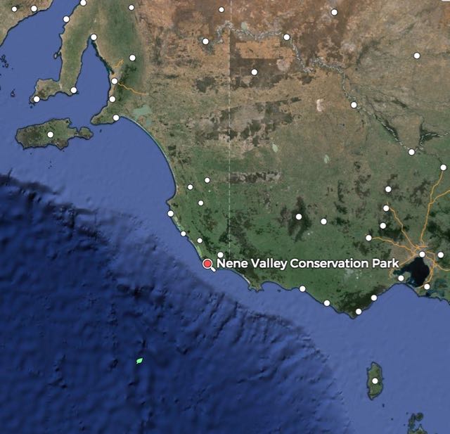
Above:- Map showing the location of the park. Map courtesy of mapcarta.com
The Nene Valley was declared a Conservation Park in 1972 and is about 373 hectares in size. It is named after the Nene Valley, a 333 ton wooden barque, launched in England in 1852. Built for the colonial trade to India and Australia it was on its second voyage to the southern hemisphere in 1854, bound for Portland Bay and Port Fairy in Victoria, from Gravesend in England. During this period, international sailing ships travelled on Great Circle Routes: south down the mid-Atlantic and then east across the Southern Ocean. Navigation was still uncertain and the first approach to land was always a risky business. In October 1854, the lookout on the Nene Valley saw breaking surf in the darkness and reported land ahead. The Captain decided it was only low cloud and sailed on.
The Nene Valley went aground soon afterwards immediately in front of what is now the town of Nene Valley. The stranded vessel was driven ashore and broke up. The crew and nine passengers all survived, but four sailors drowned the following day during a salvage attempt. The shipwreck was a local landmark on the beach until the 1930s. I have not been able to find a picture of the Nene Valley.
I last activated this park in June 2014 and set up off a little track not far from the Nene Valley town itself. It was quite noisy there due to power lines. For more information on that activation and extensive information on the park, please have a look at my previous post at…..
https://vk5pas.org/2014/06/12/nene-valley-conservation-park/
This time around I followed a sandy track on the north eastern side of the park and set up amongst the scrub. I was hoping that the scrub would afford me some protection from the winds. I was wrong.
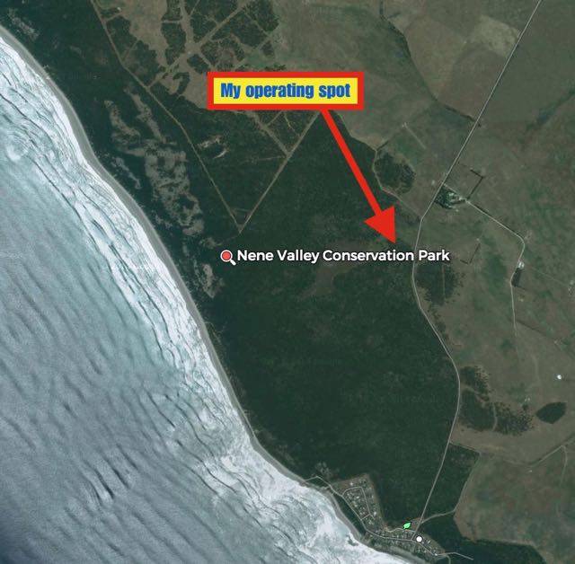
Above:- Map showing my operating spot. Map courtesy of mapcarta.com
I started calling CQ on 7.090 and fortunately it wasn’t long before I had a little pile up going. I am thankful to all the callers for keeping their overs short. And I must apologise for this. I normally like a little bit of a chat, but the weather conditions were so terrible, I wanted to get to 44 QSOs as quickly as possible and get back into the warmth of the 4WD.
Second up was Rex VK3OF, another amateur who has recently qualified for a number of WWFF & VK5 Parks certificates. This was followed by Tony VK3CAT mobile, and Alan VK5FAJS. Alan had made the wise decision after Tantanoola Caves to seek out a warm location.
My 13th contact in the park was not unlucky at all. It was Rob VK4FFAB who was portable in the Kondalilla National Park, VKFF-266 with a nice 5/5 signal. I also spoke with Ken ZL4KD who called in from Christchurch, and Erwin VK3ERW who was portable on SOTA peak Maher Hill VK3/ VE-233 with a beautiful 5/9 signal.
It was exceptionally hard to keep the squid pole up during this activation. It collapsed about 6 or 7 times and on many occasions, the legs of the dipole were either flapping around in the wind or were dragging along the ground. And it only got worse, as the aluminum squid pole holder, bent at almost right angles (see below).
After getting 49 contacts in the log, it was time to make a hasty retreat. I was cold and wet and I didn’t know how much longer the squid pole would take the punishment. It was off to Col VK5HCF’s house for a nice warm coffee and then out for tea to the South Aussie Hotel at Mount Gambier with Col, and John VK5NJ and his wife Tanina.
The following stations were worked:-
References.
Department of Environment and Natural Resources, ‘Small Coastal Parks of the South East Management Plan’ 1994.
District Council of Grant, https://www.dcgrant.sa.gov.au/page.aspx?u=663
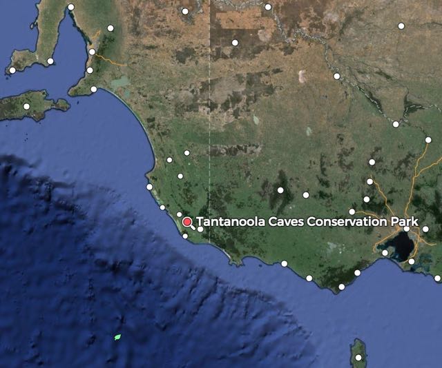
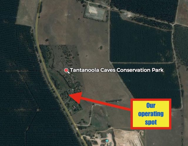
My next park activation for Monday 8th June 2015, was the Tantanoola Caves Conservation Park, VKFF-804. This was to be another unique park for me for the World Wide Flora Fauna program (WWFF). I have activated Tantanoola Caves previously as part of the VK5 National and Conservation Parks Award, but the park has recently been added to the WWFF program, so this was another park that I was hoping to get 44 contacts from.
Tantanoola Caves CP is about 430 km south east of Adelaide and is located just off the busy Riddoch Highway.
I last activated this park in June 2014 whilst I was in the area for the 2014 SERG Convention. I activated the park from a lawned area just below the carpark.For information on that activation and information on the park, please have a look at……
https://vk5pas.org/2014/06/12/tantanoola-caves-conservation-park/
But this time around I wanted to find a new operating spot, so I drove in to the carpark and out again and up the Riddoch Highway, and then back into the carpark and out again. I had pulled up on the side of the Highway, just north of the park, when a car pulled up behind me. Not knowing what was really going on, I looked in the rear vision mirror and saw a gentleman approaching. Fortunately it was not a road rage incident….it was Alan VK5FAJS. He was aware through parksnpeaks that I had intended to activate the park and had come along with his wife Georgie for a look. So we decided to go back into the carpark and set up on the lawn just below the carpark.
There are a few wooden benches and tables here, so we used one of those as our ‘shack’ for this activation. We used my Yaesu FT-857d, 40 watts (when I was operating and lowered the power for Alan), and my 40m/20m linked dipole.
I started off first and called CQ on 7.095 and this was answered by Col VK5HCF in Mount Gambier, followed by Rob VK4AAC/5 on Kangaroo Island, and then Albert VK3KLB. I went on to work 21 stations, so almost half way to the 44, when we swapped drivers. Alan was a bit reluctant to take over the mic from me, but I was more than happy to see Alan have a go and qualify the park. It wasn’t long before Alan had racked up his required 10 contacts.
I then jumped back into the drivers seat again and called CQ and this was responded to by the ever reliable John VK5BJE, then Tom VK5FTRG, and then Paul VK3DBP (who has recently qualified for quite a few VK5 Park certificates). The 40m band was behaving and I had a steady flow of callers from VK2, VK3, and VK5. Amongst that lot was Gerard VK2IO who was portable on SOTA peak Mount Gibraltar VK2/ MN-024.
I pushed on and ended up with a total of 49 contacts on 40m. Unfortunately the weather was pretty horrible and we had regular showers, which meant I was not able to try 20m as we were getting wet. The shower were so heavy at times, that the water was seaping through the bothy bag.
The following stations were worked on 40m SSB:-
After leaving the SERG Convention on Sunday afternoon (7th June 2015) I drove up to the Blue Lake at Mount Gambier for some mobile action. My mobile set up is an Icom IC-7000 and a Codan 9350 self tuning antenna mounted on the read of my Toyota Hi Lux.
As I was driving around the edge of the lake, I heard Tony VK3VTH on 14.311. Tony was portable in the Dergholm State ParkVKFF-756 in the far west of Victoria, about 390 km west of Melbourne. Tony was working into Europe, and was a little weak, but as this was a unique park for me, I thought it was worth giving him a call. It took a little while to get through the European pileup, but eventually we made it (5/3 sent and 4/1 received).
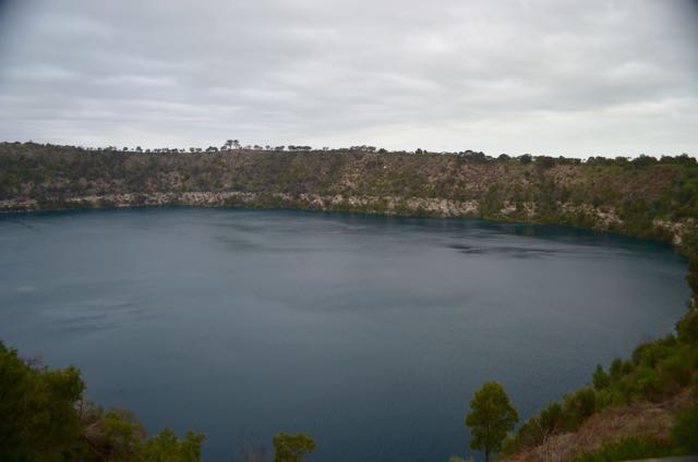
Above:- The Blue Lake at Mount Gambier.
I then changed bands to 40m and worked Paul VK3HN who was portable on SOTA peak, Mount Gordon, VK3/ VN-027 (5/7 sent and 5/5 received). I then spoke with Peter VK3ZPF who was calling CQ for the VK Shires Contest. Peter had a beautiful 5/9 signal.
I then pulled up at the Valley Lake lookout, and I had a further two SOTA contacts. The first was with Rod VK2TWR who was portable on Wullwye Hill VK2/ SM-085, east of Jindabyne. And the next was with Allen VK3HRA who was portable on VK3/ VW-017 North Burranj Range, in the Black Range State Park VKFF-751.
I then tuned up the band and found Ian VK1DI calling CQ from another unique VKFF reference area for me, the Dunlop Grassland Nature Reserve, VKFF-839. This is one of the newly added VKFF areas to the WWFF program. Ian had a nice strong 5/8 signal and he reciprocated with a 5/8 signal report for me.
I then changed over to 20m and started calling CQ on 14.275. Almost immediately my CQ call was answered by Jos ON4ATK in Belgium (5/7 sent and 5/5 received). This was followed by Ted VK4AVG (5/9 sent and 5/8 received). But things dried up after this with no further takers.
So I tuned across the band and spoke with Theo OT4A in Belgium (5/9 sent and 5/7 received), Dan S59N in Slovenia (5/8 sent & 5/6 received), Jose EA3NG in Spain (5/9 both ways), and Tom DJ7ZZ in Germany (5/9 both ways).
I finished off the afternoon with another SOTA contact. This time with Matt VK2DAG who was portable on SOTA peak, Bakers Downfall Hill VK2/ NW-006, not far from the famous Hanging Rock.
It was time to head back to Mount Gambier and a quick shower and off to the SERG Convention Dinner held at the Scout hall. It was nice to try out the new antenna on the vehicle and get a bit of DX in the log.
After trying to make myself beautiful I headed back to the scout hall in Margaret Street at Mount Gambier, and listened to a sum up of the weekend by the SERG President, Tim VK5AV, followed by a very interesting talk on Surface mounted components, and then the presentation of certificates for the National Fox Hunting Championships. I then enjoyed avery nice meal in the adjacent hall consisting of soup, Roast Chicken, and Apple crumble. I even won a bottle of nice red in the raffle, which was quickly consumed over dinner.
After leaving Ewens Ponds Conservation Park I headed off to the Piccaninnnie Ponds Conservation Park (CP), which was to be another unique park for me for the VK5 National and Conservation Parks Award.
Piccaninnine Ponds CP is located about 32 km south east of Mount Gambier, and about 480 km south east of Adelaide. It is very close to the South Australian/Victorian border.
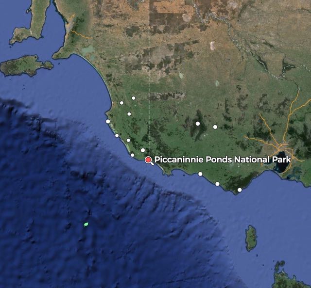
Above:- Map showing the location of the park. Map courtesy of mapcarta.com
Piccaninnie Ponds has been recognised as a wetland of international importance. The park is very popular with scuba divers and snorkellers. The crystal clear waters have been slowly filtering through the limestone and forming the Pond’s features over thousands of years. The freshwater rising to the surface under pressure has eroded a weakness in the limestone to form The Chasm. This same process has formed the large underwater cavern known as The Cathedral creating its majestic white walls of sculptured and scalloped limestone.
The park also incorporates the beachOn land, take a walk along the beach and see the freshwater springs bubbling up onto the sand. These springs are used by birds for freshwater and are also a favourite spot for shellfish.
There is also a walking trail through coastal wattle and beard heath to the ponds outlet. The walk then leads inland via boardwalks into silky tea-tree and cutting grass to a lookout where views of the wetland and bamboo reed and bulrush can be seen.
I drove down the Glenelg River Road and then turned into Piccaninnie Ponds Road. The park is very well signposted.


I drove into the main ponds carpark, which was absolutely chocker block full of cars and activity. There was a young lad with a generator running, filling up oxygen tanks for the divers that were about to head off for a dive. There was no room to set up here and it was definitely too noisy. But I did take the opportunity of walking down the track a short distance to the ponds, which were alive with activity. A number of scuba divers had just entered the water. There was also a large amount of birdlife including Geese and Herons.
I then drove down to the carpark at the end of the road near the beach. I would have liked to have set up on the beach itself, but it was extremely windy and operation from there would have been too oppressive. So I turned back around and headed back along Piccaninnie Ponds Road and found a track leading off into the scrub. That is where I set up. And with some difficulty. It was exceedingly windy.
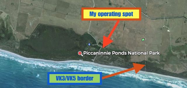
Above:- Map showing my operating spot. Map courtesy of mapcarta.com
Prior to calling CQ I had a tune around the band and found Rod VK2TWR calling CQ on 7.090 from SOTA peak Pine Hill, VK2/ SM-083. Rod was QRP 5 watts and had a good strong 5/8 signal. Not a bad way to start the park activation, with a SOTA QSO. I then moved down to 7.085 and started calling CQ and this was answered by Adam VK2YK who was portable in the Worimi National Park VKFF-614, running just 5 watts (5/3 both ways).
A steady flow of callers followed from VK3, VK5 & VK7. And then amongst the VK’s, I heard Ken again, ZL4KD with a good 5/5 signal. Not bad considering this was just before 12.30 p.m. on 40 metres. Ken gave me a 5/5 into Christchurch. A few calls later, I had a SOTA trifecta. Bernard VK2IB/3 was first to call, on SOTA peak VK3/ VE-241, south east of Wodonga. Next was Andrew VK1NAM portable on SOTA peak Bullen Range VK1/ AC-035, and then Allen VK3HRA portable on SOTA peak Mount Byron VK3/ VW-015 which is located in the Black Range State Park VKFF-751.
A few calls later, I received a call from Gordon VK5GY who was portable in the Morgan Conservation Park. It was a pleasant surprise to get a VK5 Park to Park contact with Gordon.
My last contact on 40m was with Jeff VK5JK at Encounter Bay, who always has a strong signal. I then lowered the squid pole and removed the links in the dipole, and started calling CQ on 14.307. First taker there was Adam VK2YK mobile, followed by Daniel VK6LCK and then Ian VK6DW.
It was approaching 1.00 p.m. and I still needed to get back to Mount Gambier for the SERG Convention, so it was time to pack up and hit the road. I had a total of 35 contacts in the log, including four SOTA contacts, one VK5 Parks contact, and two VKFF park contacts.
The following stations were worked on 40m SSB:-
The following stations were worked on 20m SSB:-
References.
National Parks South Australia, 2015, <http://www.environment.sa.gov.au/parks/Find_a_Park/Browse_by_region/Limestone_Coast/Piccaninnie_Ponds_Conservation_Park>, viewed 12th June 2015
Following the Convention wrapping up at about 5.00 p.m. on Saturday 6th June, 2015, I decided it was a bit too early to head back to the motel. Plus I knew that the VK Shires Contest had commended at 0600 UTC.
So I travelled west out of Mount Gambier, hoping to get a few mobile contacts with my Icom IC7000 and Codan 930 self tuning antenna on the back of the Toyota Hi Lux.
My first contact was with Nigel VK5NIG who was calling CQ Contest on 7.098 with a very fine 5/9 signal. I then spoke with VK6DW, followed by Rob VK4FFAB, and then Tony VK3VTH who was operating portable in VKFF-046.
I then pulled in to Stony Flat Road from the Riddoch Highway, and had a tune around the 40m band which was alive with contesters. I found 7.075 clear and called CQ. First taker was John VK4BZ portable at Lake Broadwater Conservation Park, followed by Cliff VK2NP.
I worked a total of 23 stations in VK2, VK3, VK4, VK5, and VK6 in the contest from the vehicle. I then had a chat with my old mate Ted VK6NTE and Jess VK6JES. During that QSO, Owen ZL2OPB called in from New Zealand with a lovely 5/7 signal (5/9 received).
And to finish off the night I spoke with Koh JI1ICF in Japan who had a very strong 5/9 signal (5/7 received).
After my activation at Penambol Conservation Park I headed back into Mount Gambier and attended the South East Radio Group (SERG) Convention at the scout hall at Margaret Street.
I met up with a number of the SERG guys including Col VK5HCF, Tony VK5ZAI, Tim VK5AV, and John VK5DJ.
I set up a display relating to the VK5 National and Conservation Parks Award and the World Wide Flora Fauna (WWFF) program. On display I had a number of award certificates, my Yaesu FT-817nd, my Yaesu FT-857d, 44 amp hour power pack, LiFePo batteries, SLAB batteries, bothy bag, handheld GPS devices, solar panels, & antennas. I also had a number of promotional handouts.

There were a number of hams in attendance from VK5 and VK3. This included a number of traders, including Ross from Strictly Ham.
This is the 51st year of the SERG Convention and the National Fox Hunting Championships. For more information, have a look at…..
After leaving Christmas Rocks I was hoping to activate Talapar Conservation Park. However, the GPS led me on a wild goose chase and despite my best efforts I could not get into the park. This included following an 8km section of very sandy and boggy track which showed on the GPS leading straight into the park. But by the time I got to the end there was a locked gate and I was still 2 km short.
I was starting to get very frustrated and tired, so I took an easy option and headed back into nearby Naracoorte and activated the Naracoorte Caves National Park, VKFF-380. This was not a new park for me (I had been there before in June, 2014 – see below), but I knew that it was an easy park to access and there was shelter there from the never ending rain.
https://vk5pas.org/2014/06/12/narracoorte-caves-national-park/
The Naracoorte Caves National Park is about 351 km by road, south east of Adelaide.
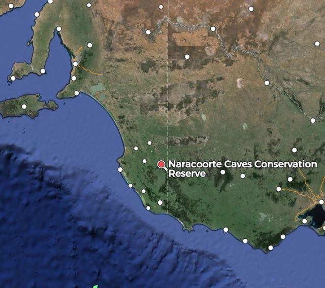
Above: Map showing the location of the park. Map courtesy of mapcarta.com
Naracoorte Caves National Park is Australia’s only World Heritage site, officially recognise in 1994 due to its importance to the fossils located there. There are 28 known caves in the park. Four are open to the public. The park preserves Australia’s most complete fossil record for the past 500,000 years. For more detailed information, please see my previous post on this park, or have a look at the following site…..
http://www.environment.sa.gov.au/naracoorte/Home
I set up in a BBQ shelter shed on the edge of the oval, which is adjacent to the main carpark. It afforded me plenty of shelter from the rain which constantly came down. You know it is wet and cold when the kangaroos are sheltering underneath trees on the oval, which they were. For this activation I ran the Yaesu FT-857d, 40 watts and my 40m/20m linked dipole supported on a 7 metre squid pole.
I started off on 40m and called CQ on 7.095. First taker again was Tony VK5FTVR, followed by Larry VK5LY, Les VK5KLD and Col VK5HCF. All with great signals from all around South Australia. Getting wet and cold was made up for by the large number of callers who gave me a shout. Adrian VK5FANA called in again, running his 5 watts as per usual, with a very nice signal. I was also called by Lou VK5EEE who was formerly G4OJW in the UK. I was just Lou’s third QSO with his new VK call. Welcome to Australia Lou.
A number of other hams running QRP also called in, including Norm VK5GI and Greg VK5GJ, both running just 4 watts (5/7 sent and 5/9 received). And also Adrian VK5AW running 5 watts from the Riverland (5/9 both ways). Quite a few mobiles also called in, including Ian VK3TCX mobile north of Bairnsdale, Gerard VK2IO, Peter VK3TKK, Wayne VK2PDW, and Peter VK3PF.
Sadly, at about 0540 UTC (3.10 p.m. local time), two stations from VK5 & a VK2 (I know their call signs, but will not mention them here) came up on adjacent 7.093. They are regular participants in the Kandos Net which commences at 0600 UTC on 7.093. I was aware that the net was to start at the time and had indicated that I was going to go QRT prior to the net commencing. However, that did not stop those individuals from firing up on 7.093, just 2 kc below me, where I had been for about one hour. Clearly they knew I was there, and others were calling/working me. It was impossible to continue to 7.095 due to the bleed over.
I normally bite my tongue. But one of these individuals had previously communicated to me that park & SOTA activators should stay away from 7.093 as it was ‘their net frequency’. On that occasion, after informing this individual that no-one ‘owned’ a frequency, it appears that it has fallen on deaf ears. So I came up on 7.093 to calmly voice my disapproval of their poor behaviour. One of the VK5’s sheepishly apologised, but the VK2 station accused me of getting ‘a bit upset over nothing’.
But out of everything bad, comes something good. There are some excellent and professional operators around. And here are two of those. On the record I would like to thank both Tom VK2KF and Tom VK4ATH (net controllers for the Kandos Group), who had personally heard what had occurred and were very quick to apologise, both via e-mail and on air for the behaviour of a small few. Not that they should have to apologise for others. But they did. Thanks to both Toms. The Kandos Net is a terrific net which has been running for a very long period of time and should in no way be tarnished by the behaviour of a very select few.
And also thankyou to the two hams who followed me down to 7.093 and also supported me and voice their disaproval.
I then headed up to 14.2498 and started calling CQ. This was answered immediately by Ray KB6LQV in California in the USA with a nice 5/9 signal. John VK5BJE was kind enough to spot me on the DX Cluster and this resulted in the European park hunters finding me. It wasn’t long before the regulars were giving me a shout. On 20m I worked into the USA, Belgium, Italy, Germany, France, Hungary, Poland, Spain, Israel and VK. I went on to work 24 stations on 14.248 until things slowed down.
So I tuned across the band and found Tony G7OEM who was pedestrian mobile, calling CQ on 14.197. Tony had quite a pile up, but I eventually made it (5/5 both ways).
After 2 hours in the park I had a total of 63 contacts in the log. It was time to head off to Mount Gambier. It was now 4.10 p.m. and I still had a 100 km drive ahead of me.
Thankyou to those that spotted me on parksnpeaks and thanks to I5FLN, F4HMR, VK2SOL, and IZ1JLG for spotting me on the DX Cluster.
The following stations were worked on 40m SSB:-
The following stations were worked on 20m SSB:-
Amateur Radio, Short Wave Listening, travel and history
Amateur radio experiences with VK1DA
Brisbane - Australia
german amateur radio station
Summits On The Air
SOTA on the peaks, wilderness QRP and some bushwalking
A fine WordPress.com site
Amateur Radio Adventures
Summits on the Ai
Amateur radio station from Belgium
Radio craft, homebrew, QRP/SOTA, AM
Ego loqui ad viros super montes
My adventures with Amateur Radio and Geocaching!
The rantings of VK2GAZ on his SOTA experiences in Australia
A survivor, with minor cuts and abrasions.
The Art and Craft of Blogging
The latest news on WordPress.com and the WordPress community.
Blog of Justin Giles-Clark VK7TW's SOTA and amateur radio adventures.
Occasional SOTA & Microwave operation
