Day four, Lower Goulburn National Park VKFF-0741

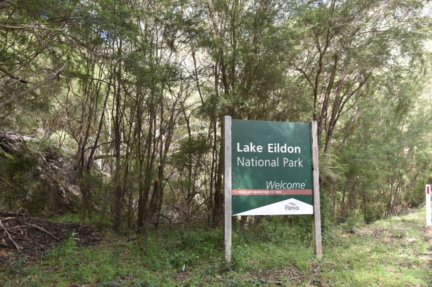
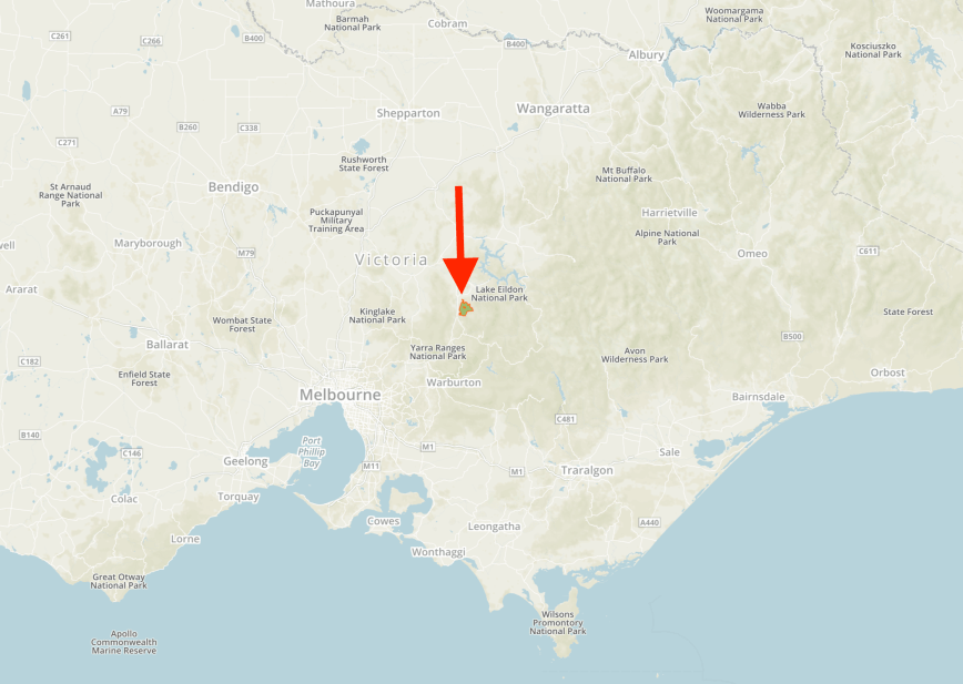
It was now day four of our trip, Monday 19th November 2018.  We had only one planned park activation for the day, and that being the Lower Goulburn National Park VKFF-0741.  This was to be another unique park for both Marija and I for both the WWFF program and the KRMNPA.

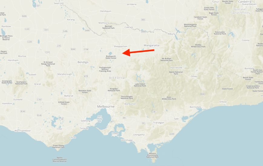
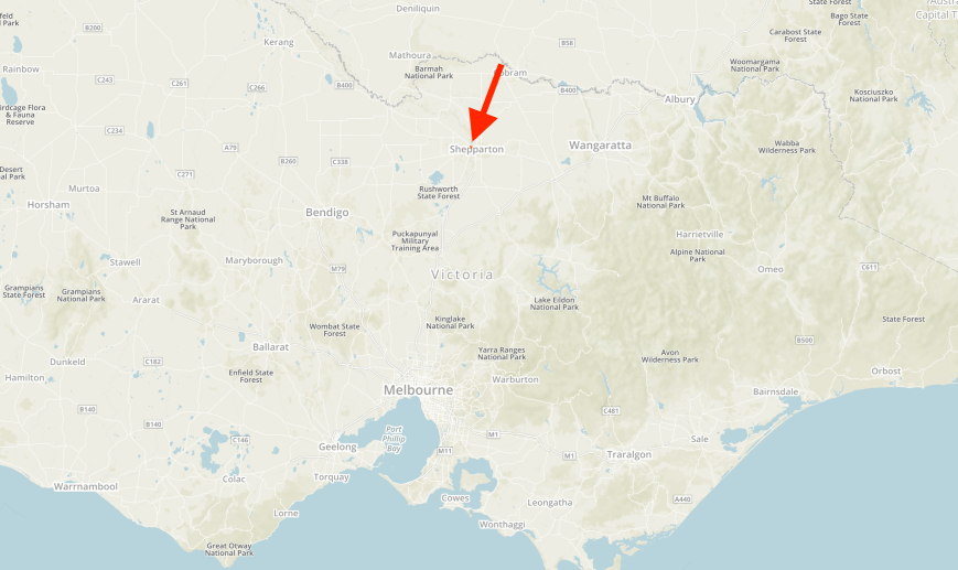
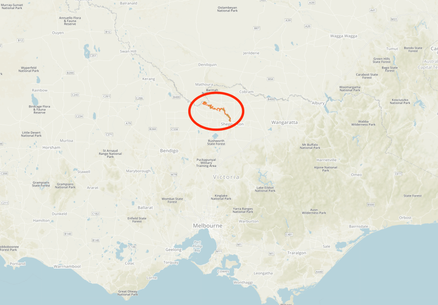
The park is located just to the north of Shepparton and stretches all the way to the mighty Murray River to the east of Echuca/Moama.

Screen Shot 2018-12-09 at 5.29.51 pm.png

Above:- Map showing the location of the Lower Goulburn National Park.  Map courtesy of Protected Planet.

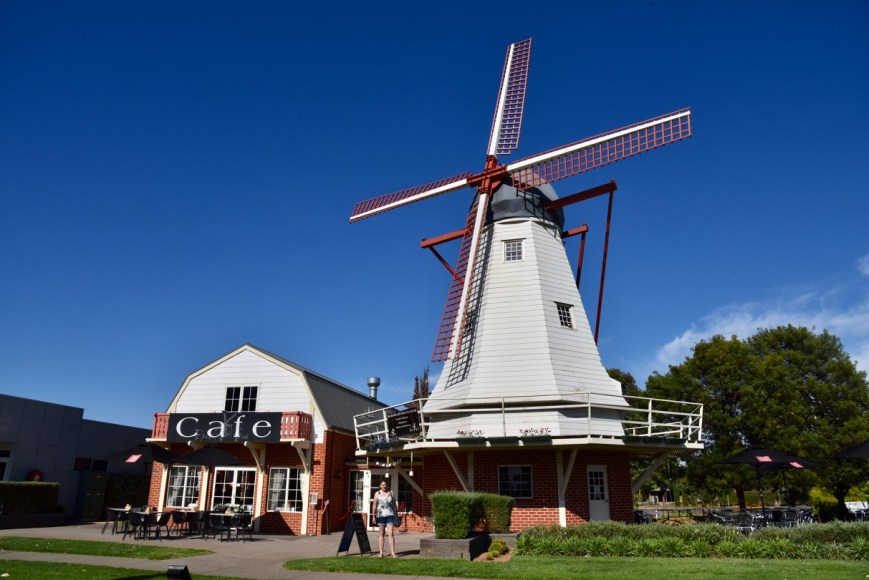
For breakfast we headed to the Windmill at Emerald Bank.  We enjoyed some bacon and eggs and coffee, and purchased some of the chocolates which are on sale there.

DSC_3959

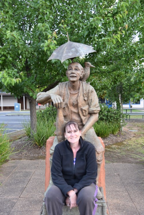
We then headed south out of Shepparton on the Goulburn Valley Freeway and into the little town of Murchison, which is located on the banks of the Goulburn River.  The town features a number of cow statues called ‘Mooving Art’.  In 1999, Shepparton’s CBD marketing committee Shepparton Show Me introduced Moooving Arts predecessor – the Merry Moos, for a Christmas campaign.  The Merry Moos were so successful it was decided to expand the concept and Moooving Art was born.  They can now be found in Shepparton and surrounding towns, including Murchison.

We then travelled out to the Murchison cemetery which contains the grave of King Charles Tattambo, the leader of the Goulburn tribe at the time of European settlement.  Tattambo died in 1866.  His son, Captain John, and his widow, Queen Mary, were buried next to King Charles’ grave in 1874.

We then visited the Murchison Italian Ossario – War Memorial and Chapel.  During World War II an estimated 4,000 Italian, German, and Japanese were sent to prison camps in the Goulburn Valley, including Murchsion.  Many died whilst in the camps and were buried in the Murhcison cemetery.  In 1956 the infamous floods of that year caused serious damage to many of the graves.  The mausoleum was completed in 1961 and it was agreed that all Italian POW’s and internees who died in Australian prison camps, should be interred in the mauoleum.

Our next stop was the stately mansion, Thornebridge.  The mansion was built in 1868 by Henry Thorne as a Commercial Travellers Inn, and was known as Thornes Bridge Hotel and Store.  In 1895 it was renamed Gregorys Bridge Hotel and Store.  From that time it was owned by many people until it was delicenced in 1969.  Today, after much loving tender care, the mansion haas been transformed into historic luxury accomodation.  The building is shadowed by a heritage listed London Plane Tree, planted in 1913.  It is the 4th biggest in the State.

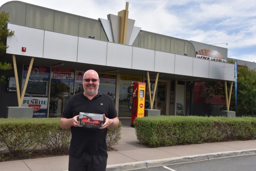
We then returned to Shepparton and visited the Shepparton Motor Museum.  And whata  great museum this is, whether you are a car buff or not.  The museum features up to 100 classic, heritage and muscle cars, which have been generously loaned or donated to the museum.  You can also find motorcycles and car collectables.

There are some real classics here to be viewed.  And they have all generously been loaned for display by motoring enthusiasts all across Australia.  The museum’s collection is constantly changing.

This slideshow requires JavaScript.

There is also a Furphy collection here.  What is a Furphy I hear you ask?  A furphy is a water cart designed and constructed by a company established by John Furphy of J. Furphy & Sons of Shepparton, Victoria.  The steel and cast iron tanks were first made in the 1880s and were used on farms and by stock agents.  Many Furphy water carts were used to take water to Australian Army personnel during World War I in Australia, Europe and the Middle East.

Outdoors there is a small collection of tractors and an old fire engine.

The museum also features an extensive bicycle collection.  In fact it is the largest and rarest collection of bicycles in Australia, and one of the largest in the world.  The bicycles are the collecting passion of Paul and Charlie Farren.  The majority of the bicycles are pre 1900, with the most recent bike being from about 1910.  The Farren collection includes penny farthings of all sizes, bamboo bikes, curious tricycles, women’s sidesaddle bikes, tandems/three seaters and “sociables” that allowed riders to sit side by side.

And of course during my visit to the museum I was able to track down a radio collection.

And my thanks to Marija for allowing me to purchase a car during our visit.  Well, not the one I wanted.  But second best, a die cast model of a 1958 Chevy Impala.

DSC_4033

We then headed to the town of Tatura, which means ‘small lagoon’ in the local aboriginal language.  We visited the memorial for Private Robert Mactier, who was a Victoria Cross recipient.

We then visited the Tatura Irrigation and Wartime Camps Museum, a fascinating museum which tells the very interesting story of the inturnment of Germans, Japanese and Italians during World War Two.  During the Second World War there were between 4,000 to 8,000 internees held at seven camps in the Goulburn Valley.  Three of the camps housed Prisoners Of War, and the remaining four camps held internees.  Of the internee camps, Camps 1 and 2 were near Tatura and held mostly German and Italian single males.  This museum is a must if you are in the area.

This slideshow requires JavaScript.

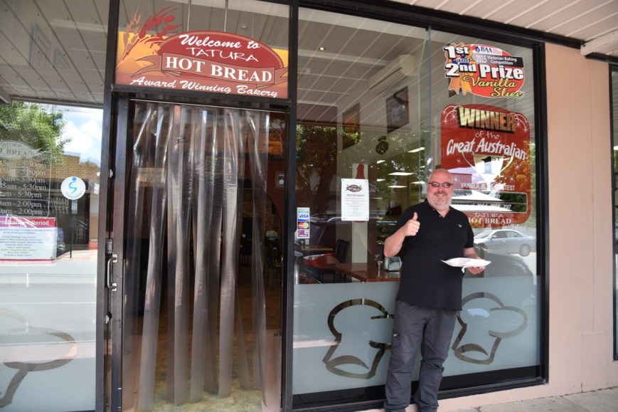
It was now mid afternoon and we were feeling a bit peckish.  One of Marija’s friends had recommended the vanilla slice at the Tatura Bakery, so that it where we headed for a bite to eat.

DSC_4057

We then ventured out to Dhurringile Mansion, a 65 room mansion which was constructed by wealthy pastoralist John Winter.  It was subsequently sold in 1907 to Everard Browne, the son of Rolf Boldrewood, the Robbert Under Arms novelist.  During the Second World War the mansion was used for the detention of German officers.  Today it is used as a low security prison, HMS Prison Dhurringile.  What a waste!  We couldn’t get close to the mansion due to the security, but took the pictures below from the Tatura Road.

Our next stop was the German War cemetery, located next to the Tatura Cemetery.  The cemetery contains the graves of 250 German civilian internees of World War One, and German civilian internees, German Army and German Air Force of World War Two, who died in Australia during the War.

We headed back into Shepparton and went to the SPC Factory Sales.  I thought they were just going to see SPS fruit products here, but I was very surprised to learn that they stock almost everything.  Australian brands of goods are stocked, with 20-70% off normal retail prices.

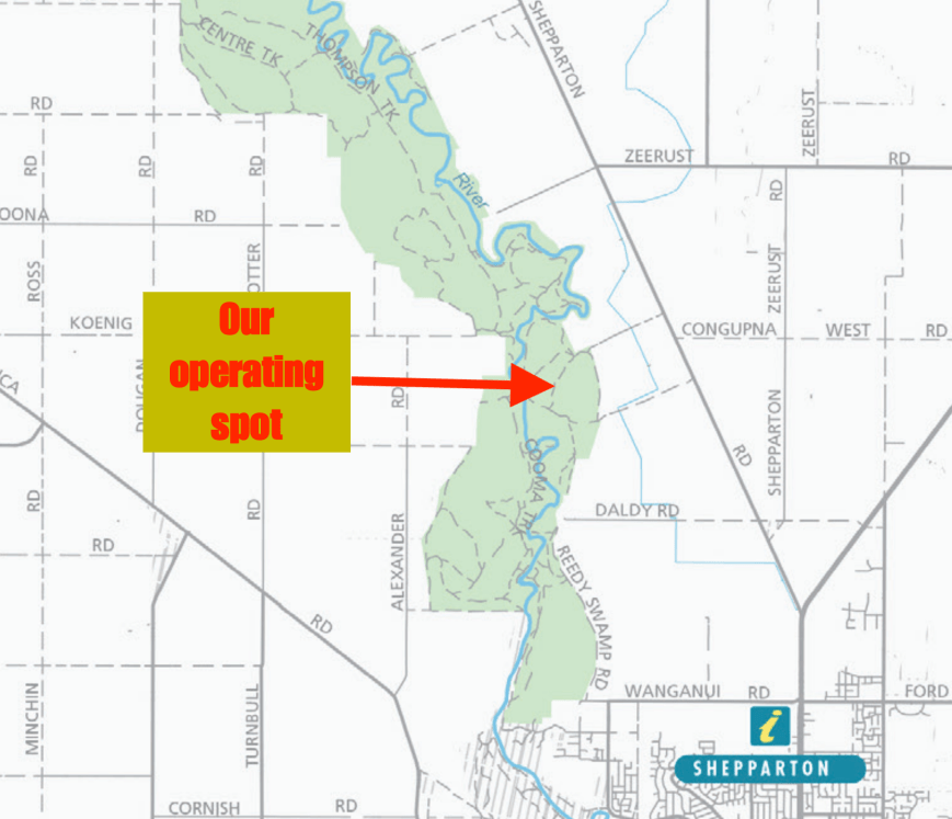
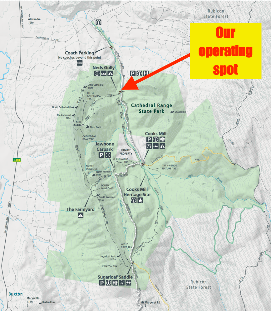
It was now late afternoon, and time to head off the Lower Goulburn National Park.   We headed out of Shepparton on Reedy Swamp Road and soon reached the park, which was well signposted.

DSC_4067

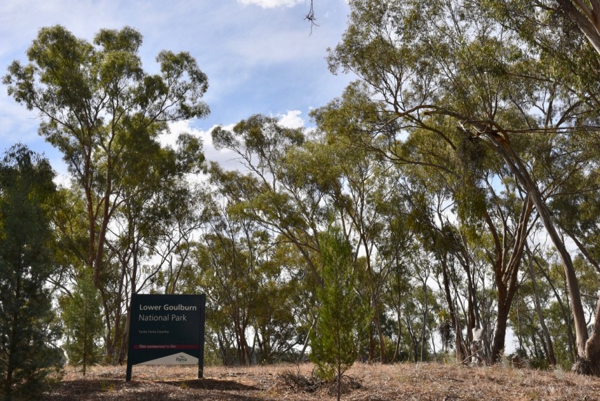
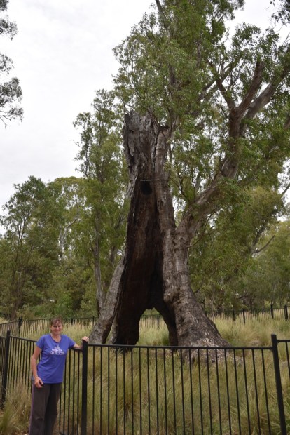
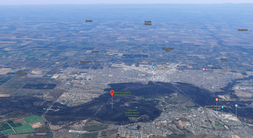
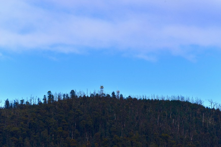
The Lower Goulburn National Park is a large park, consisting of 9,310-hectares (23,000-acres).  The Victorian State Government created the Lower Goulburn National Park, along with other new and expanded parks, in June 2010 to protect and enhance the River Red Gum forests in Victoria.  The park is renowned for its River Red Gums, Eucalyptus camaldulensis, that line much of the course of the Goulburn River and the National Park.  These iconic Australian trees have been known to reach 45 metres and live for more than 500 years.

The Goulburn River, a major inland perennial river of the Goulburn Broken catchment, part of the Murray-Darling basin, flows through the park.  The headwaters of the Goulburn River rise in the western end of the Victorian Alps, below the peak of Corn Hill before descending to flow into the Murray River near Echuca, making it the longest river in Victoria at 654 kilometres.

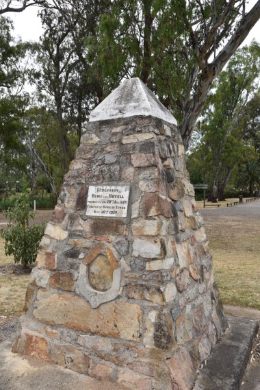
Explorers Hamilton Hume and William Hovell explored the area in 1824, naming the Goulburn River in honour of Major Frederick Goulburn (1788-1837), the first Colonial Secretary of New South Wales.

1095.jpg

Above: Maj. Frederick Goulburn.  c/o http://www.parliament.nsw.gov.au

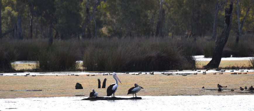
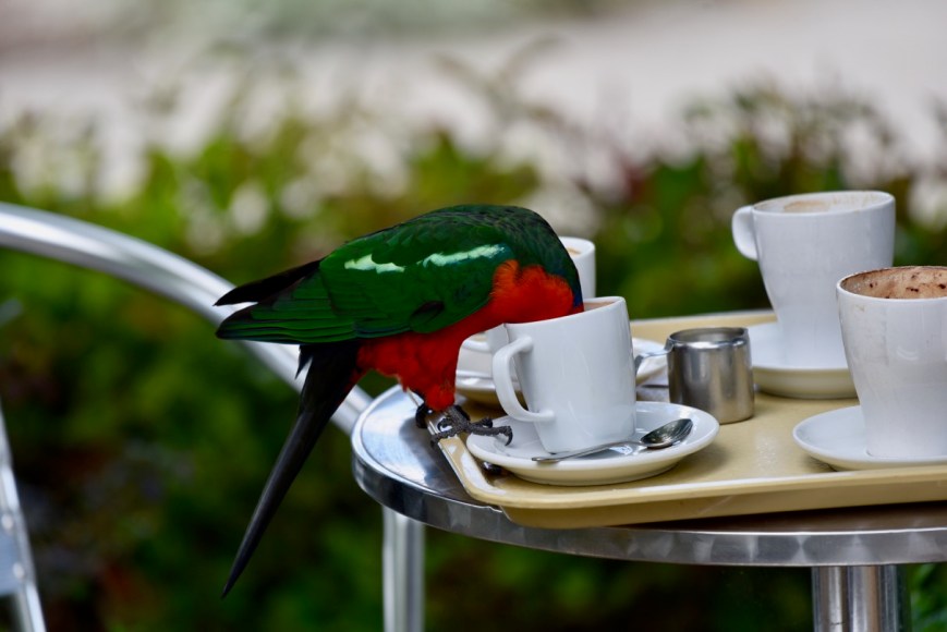
The River Red Gum forest in the park, along with the wetlands and billabongs provides habitat for numerous significant fauna species including Brush-tailed Phascogales, Barking Owls, Royal Spoonbills and Musk Ducks.  Murray Cod, Golden Perch and Spiny Freshwater Crayfish are found in the river.

Screen Shot 2018-12-09 at 5.29.38 pm.png

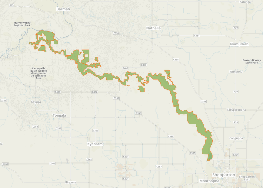
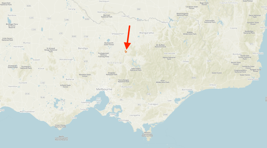
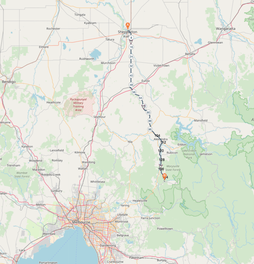
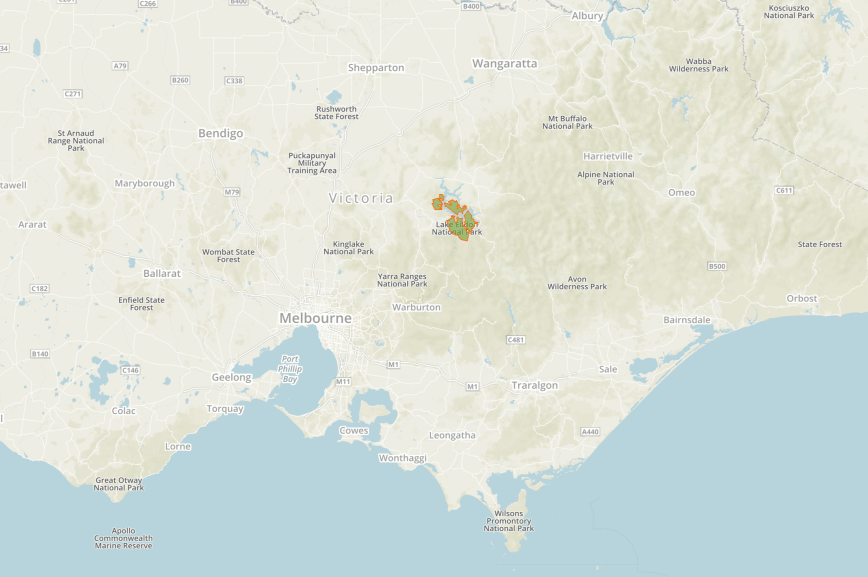
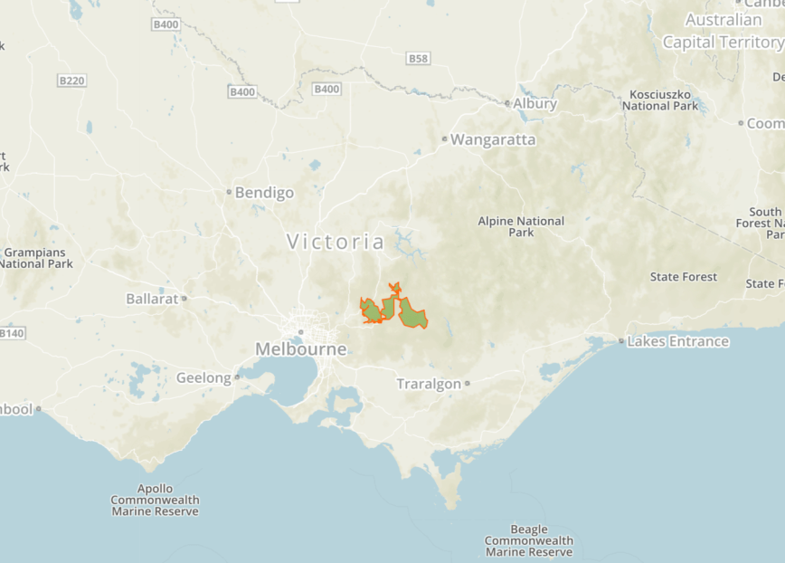
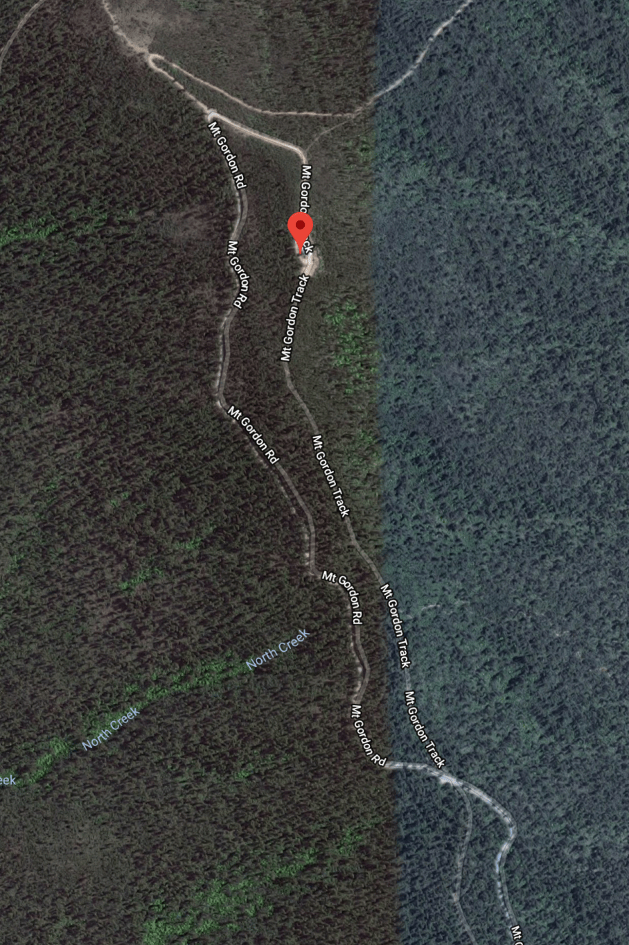
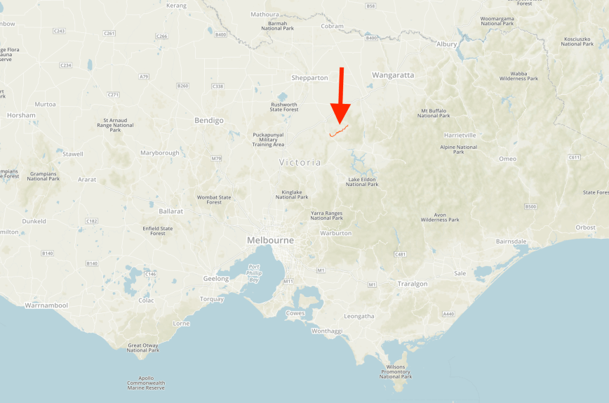
Above:- The Lower Goulburn National Park, stretching from Shepparton to near Echuca/Moama.  Map courtesy of Protected Planet.

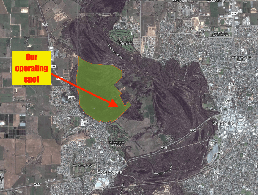
There were some nice spots to stop before we reached our operating spot.  It gave me the opportunity of taking some bird photos.  This part of park, Reedy Swamp is a haven for waterbirds.

DSC_4076

This slideshow requires JavaScript.

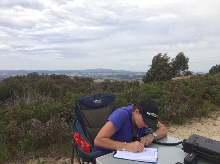
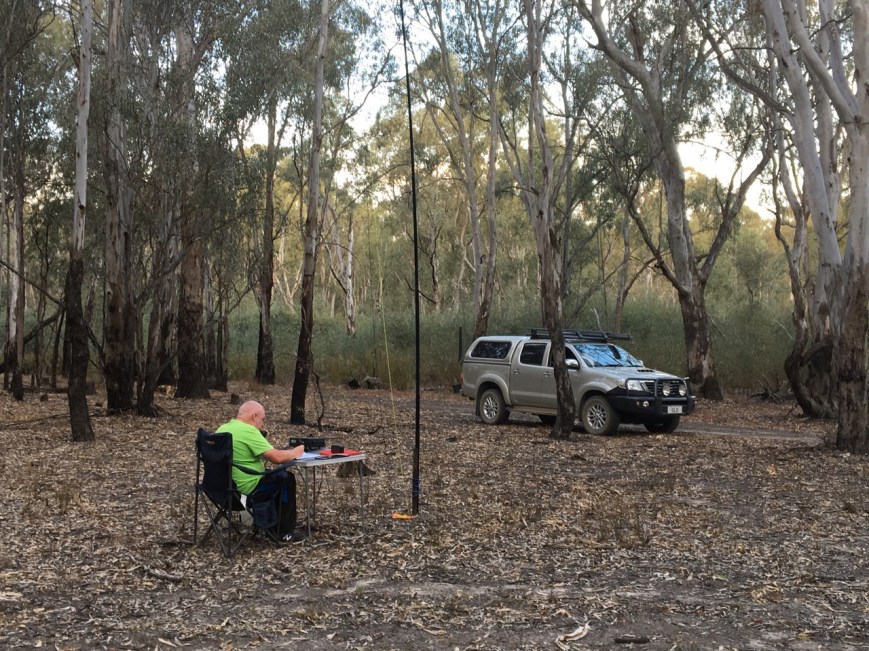
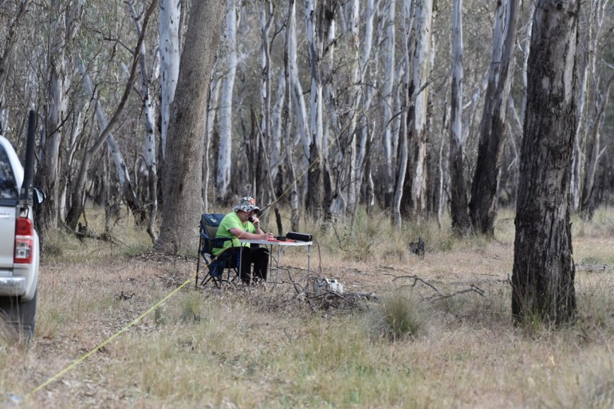
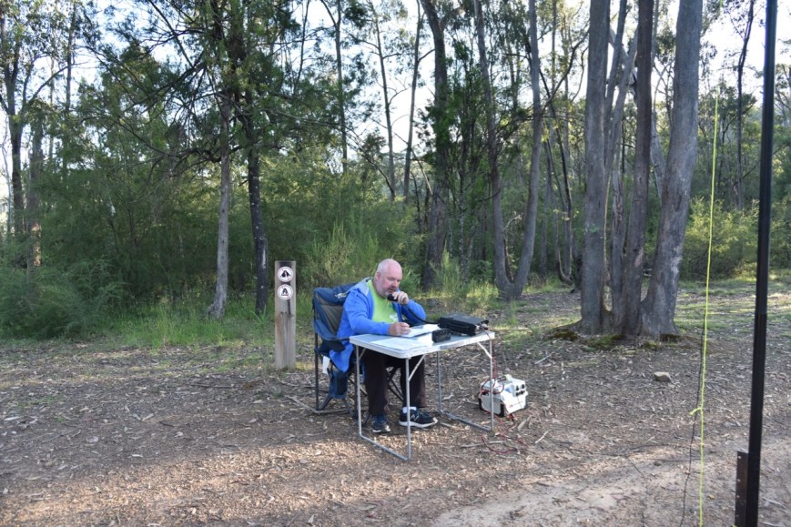
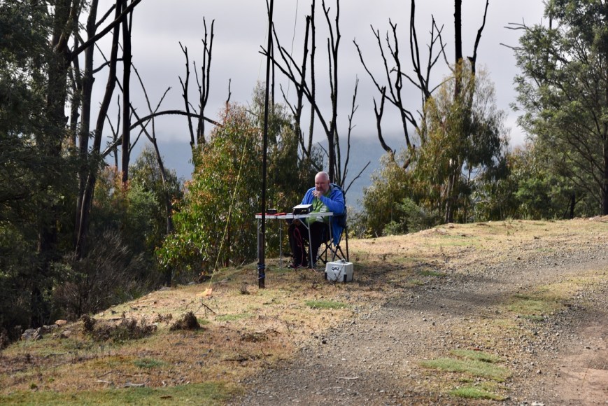
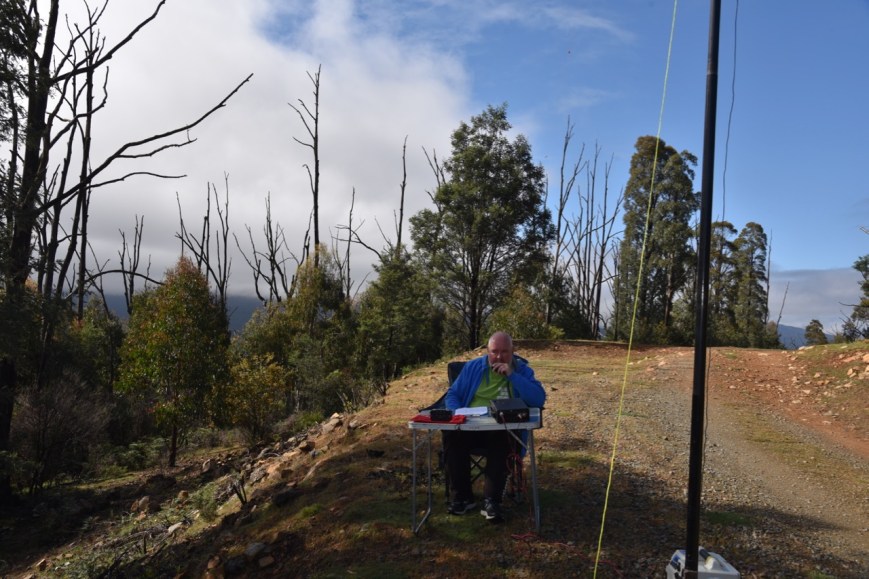
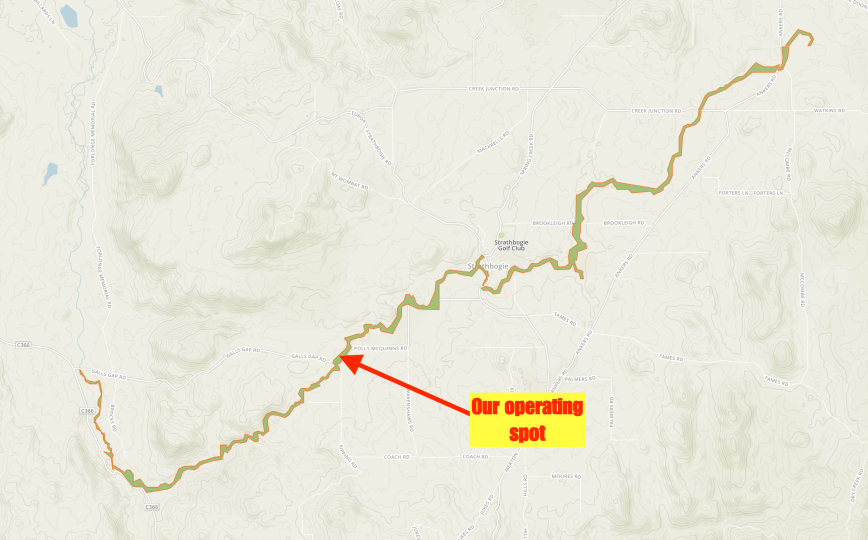
We travelled down one of the 4WD tracks off Reedy Swamp Road and set up our portable station, comprising the Yaesu FT-897 and the 20/40/80m linked dipole.

Screen Shot 2018-12-09 at 8.19.32 pm.png

Above:- Map showing our operating spot in the Lower Goulburn National Park.  Map courtesy of Parks Victoria.

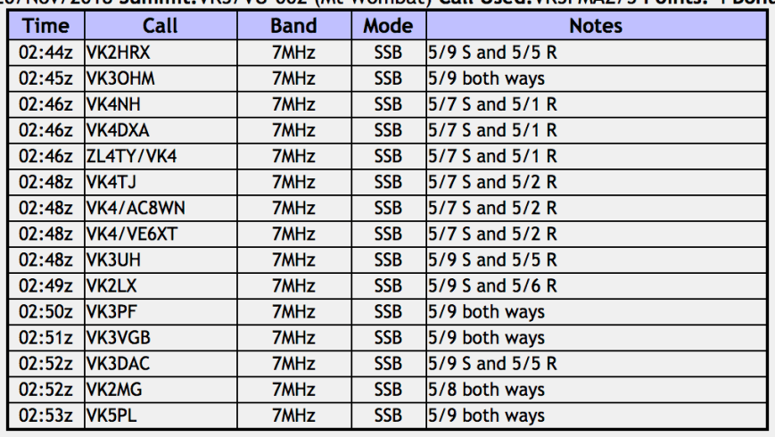
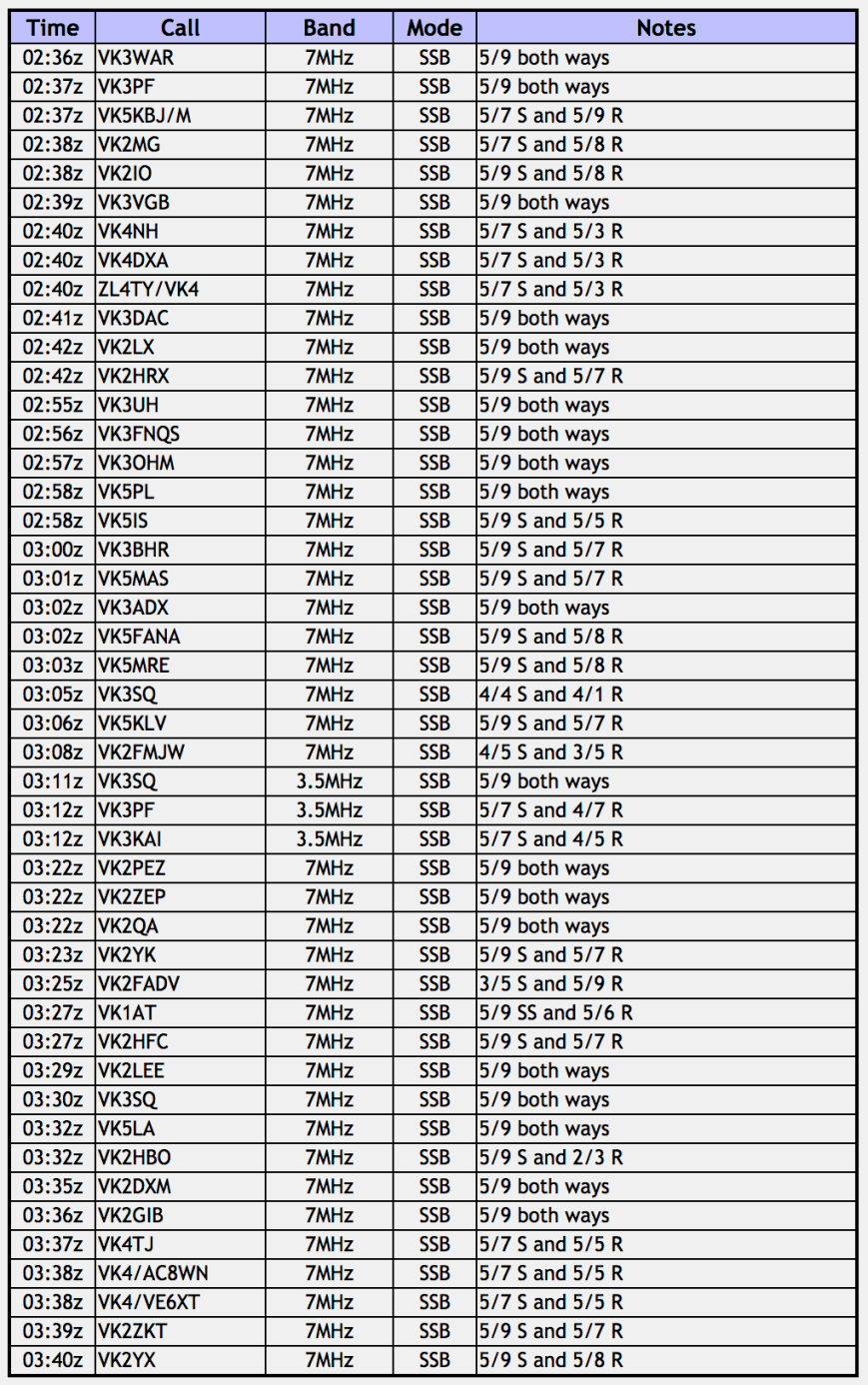
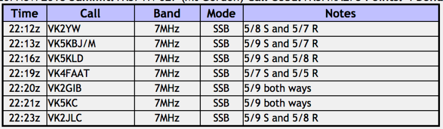
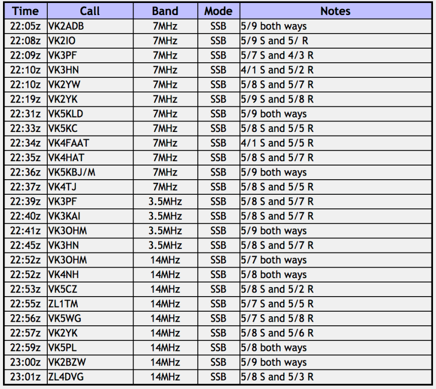
To kick off the activation Marija and I logged on 40m, Jonathan VK7JON who was activating SOTA summit Mount Mangana VK7/ SC-017.  I then moved up the band to 7.150 and started calling CQ, whilst Marija placed up a spot for me on parksnpeaks.  First to come back to my CQ call was Gerard VK2IO with a strong 5/8 signal, followed by Ray VK4NH, and then Adrian VK5FANA.  Within 10 minutes I had contact number 10 in the log, a QSO with Alan VK3ALN/p at Rye.  I logged one more station, Alan VK2MG, before swapping the mic with Marija.

Marija then called CQ and Ray VK4NH was first to come back, followed by Alan VK2MG, Adrian VK5FANA, and then Rob VK2CRF.  Marija had also soon qualified the park, with contact number 10 being a QSO with Alan VK3ALN/p.  Marija logged a further 4 stations before handing the mic back to me.

I was keen to try to get my 44 QSOs, required to qualify the park for the global WWFF program.  Unfortunately that was not be.  I logged just a further 7 stations on 40m from VK2, VK3, VK5 and VK7.  I tried calling CQ on 14.310 but had no takers there, and had to endure the ever present Over the Horizon Radar which was very strong.

To complete the activation I called CQ on 3.610 on the 80m band where I logged a total of 6 stations from VK3 and VK5.

I ended up with 24 contacts in the log, and had qualified the park for VKFF and the KRMNPA, as had Marija.

DSC_4106.jpg

Marija worked the following stations on 40m SSB:-

  1. VK7JON/p (SOTA Mount Mangana VK7/ SC-017)
  2. VK4NH
  3. VK4DXA
  4. ZL4TY/VK4
  5. BK2MG
  6. VK5FANA
  7. VK2CRF
  8. ZL1TM
  9. VK7ROY
  10. VK3ALN/p
  11. VK3FDZE
  12. VK5NJ
  13. VK2BAI
  14. VK5KLV

I worked the following stations on 40m SSB:-

  1. VK7JON/p (SOTA Mount Mangana VK7/ SC-017)
  2. VK2IO
  3. VK4NH
  4. VK4DXA
  5. ZL4TY/VK4
  6. VK5FANA
  7. VK4TJ
  8. VK4/AC8WN
  9. VK4/VE6XT
  10. VK3ALN/p
  11. VK2MG
  12. VK5NJ
  13. VK5KLV
  14. VK7ROY
  15. VK2PEZ
  16. VK2ZEP
  17. VK3FDZE
  18. VK5LA

I worked the following stations on 80m SSB:-

  1. VK3SQ
  2. VK3FDZE
  3. VK3PF
  4. VK5NJ
  5. VK3TNL
  6. VK5FANA


References.

Aussie Towns, 2018, <https://www.aussietowns.com.au/town/murchison-vic>, viewed 9th December 2018

Greater Shepparton Visitor Centre, 2018, <http://visitshepparton.com.au/moooving-art/about-moooving-art>, viewed 9th December 2018

Monument Australia, 2018, <http://monumentaustralia.org.au/themes/conflict/multiple/display/33692-german-war-cemetery>, viewed 9th December 2018

Parks Victoria, 2013, ‘Lower Goulburn National Park Visitor Guide’.

Shepparton Motor Museum, 2018, <https://sheppartonmotormuseumandcollectibles.com.au/>, viewed 9th December 2018

Wikipedia, 2018, <https://en.wikipedia.org/wiki/Furphy>, viewed 9th December 2018

Wikipedia, 2018, <https://en.wikipedia.org/wiki/Goulburn_River>, viewed 9th December 2018

Whroo Natural Features Reserve VKFF-2229

Our next intended activation, and the final one for day three (Sunday 18th November 2018), was the Whroo Nature Conservation Reserve VKFF-2229.  The park is located about 9 km south of the town of Rushworth, and about 161 km north of the city of Melbourne.

This would be the first time that the park had been activated for the World Wide Flora Fauna (WWFF) program.

Screen Shot 2018-12-08 at 10.11.56 pm.png

Above:- Map showing the location of the Whroo Nature Conservation Reserve.  Map courtesy of Protected Planet.

After leaving Spring Creek, Marija and I drove east on the Heathcote-Nagambie Road, and then north on the Nagambie-Rushworth Road.  We soon reached the southern boundary of the park which was well signposted.   There is a lot of scrub out here, and it could be confusing if you are actually within the park boundaries.  So if you intend to activate this park, you will need to ensure that you are within its perimeter, and not in  another section of scrub.  And don’t get this park confused with the Whroo Historic Area.  They are completely separate parks.

DSC_3909

The Whroo Natural Features Reserve is 5,367 acres in size, and is located on both the eastern and western side of the Nagambie-Rushworth Road.  The park supports a range of threatened flora and fauna species, including four threatened orchids.  It is of national significance as it is a key site for Swift Parrot and supports four other threatened fauna species and six threatened flora species, including the Squirrel Glider, the Grey-crowned Babbler, and the Bush-Stone Curlew.  The park was previously known as the Rushworth State Forest.

The park takes its name from the ghost town of Whroo, pronounced ‘roo’.  It is thought to be derived from an aboriginal word meaning lips.  Gold was discovered in Whroo in October 1854, one year after the discovery of gold at nearby Rushworth.  The location of the gold find was named Balaclava Hill, as it coincided with the Battle Balaclava in the Crimean War.  As a result of the rush, Whroo’s population exploded to the thousands.  However, within 4 years the population had dwindled to around 450.

Screen Shot 2018-12-09 at 12.16.01 pm.png

Above:- The view is of the “Balaclava Hill Whroo, from the north in about 1858/​9, with the workings on the horizen: the wind sails ventilate the shafts, and the drums are the whims for raising quartz by horsepower. The tramway on the left runs down to Lewis and Nickinson’s crusher. A small hand operated crusher is visible in the centre foreground.  c/o Trove

The township of Whroo was surveyed in 1856, 2 years after the discovery of gold.  In 1857 the first school had been established in Whroo.  By 1865 Whroo had a steady gold mining industry and included a mechanics’ institute and library, Presbyterian and United Methodist churches, three hotels, a cordial factory and three ore crushing mills.

Marija and I pulled off the Nagambie-Rushworth Road, into Le Deux Road, and operated from the vehicle for this activation.  Again, the equipment used was the Icom IC-7000, 100 watts, and the Codan 9350 antenna.

Screen Shot 2018-12-08 at 10.09.26 pm.png

Above:- Map showing the Whroo Nature Conservation Reserve.  Map courtesy of Protected Planet.

Our first contact from Whroo, was a Park to Park contact with Gary VK2GZ/p who was activating the Seven Mile Beach National Park VKFF-0447.  We then moved down the band to log another Park to Park, this time with John VK5FLEA/p in the Mylor Conservation Park VKFF-0785.

I then propped on 7.115 and started calling CQ after Marija had popped up a spot for me on parksnpeaks.  Andrei ZL1TM in New Zealand called in with a good 5/5 signal, followed by Andrew VK2PEZ and then Graham VK7ZGK.

I soon had 10 contacts in the log, qualifying the park for the VKFF program, with contact number 10 being a QSO with Adam VK2YK.  I logged a further 2 stations on 40m before heading down to 3.610 on the 80m band where I logged 3 Victorian stations.

It was now around 4.30 p.m. and we still had hoped to have a look at the historic town of Rushworth before reaching our destination of Shepparton.  So we hit the road again, with another park qualified for VKFF.

Marija worked the following stations on 40m SSB:-

  1. VK2GZ/p (Seven Mile Beach National Park VKFF-0447)
  2. VK5FLEA/p (Mylor Conservation Park VKFF-0785)

I worked the following stations on 40m SSB:-

  1. VK2GZ/p (Seven Mile Beach National Park VKFF-0447)
  2. VK5FLEA/p (Mylor Conservation Park VKFF-0785)
  3. ZL1TM
  4. VK2PEZ
  5. VK2ZEP
  6. VK7ZGK
  7. VK4NH
  8. VK4DXA
  9. ZL4TY/VK4
  10. VK2YK
  11. VK5FANA
  12. VK7EE

I worked the following stations on 80m SSB:-

  1. VK3PF
  2. VK3SQ
  3. VK3TNL

After packing up we drove into the Whroo Historic Reserve.  This includes the site of the former Whroo township and the Whroo goldfields.

We visited the historic Whroo cemetery.  The town of Whroo was established in 1853, however the earliest burial record at the Whroo cemetery is 1858.  It would appear that the cemetery was used for burials before it was made official.  There are about 400 graves recorded in the cemetery, however not all are marked.  Just inside the gate to the right was the Chinese section.   The 1863 Census indicates that of the 702 residents at Whroo, about 15% were Chinese.

Among the people’s sirnames at Whroo, the countries represented during the gold rush era were England (Lewis), France (Bartholmi), Sparin (Manuel), New Zealand (Murray Cluney, Rush & Bregan), Ireland (Ryan, SUllivan, Scarry, & O’Brian), China (Cheong), Prussia (Schleswig), and Austria (Holstein).

This slideshow requires JavaScript.

A short distance down the road we found an old Puddling machine, which became the main method for working the alluvial fields.  Large quantities of gold bearing clay were taken from the gullies and mixed with water in the puddlers.  A single horse would drag harrows around the circular trench to break up the clay and allow the heavier gold to settle to the bottom of the trench.

PUDDLER.gif

Above:- A puddling machine, c/o egold.net.au

This particular puddler was owned by William Puckey.  Records from 1863 indicate that there were 17 puddling machines at Whroo,  The Chinese operated four puddling machines around Rushworth and eigh around Whroo.

DSC_3924

We then entered the town of Rushworth.  Right on the edge of town there is an information board about ‘The Gold and Ironbark Trail’, a tourist drive which can be undertaken to relive the Victorian gold rush.

There is also a historic sign, the Rushworth Whistle Post.  Its purpose was to instruct the drivers of Steam Traction engines to warn any approaching horse-drawn vehicles to wait whilst the Traction engine could proceed up the narrow road and avoid frightening the horses.   There were originally two whistle posts; the remaining post is as original and was erected about 1906 to assist Anderson and Colliver, Timber Contractors, to haul timber from Whroo Forest to the Rushworth Sawmill.

We stopped of in Rushworth for about 30 minutes, and take a walk around the town admiring the many historic buildings.  Today Rushworth is a service centre, but was once a thriving and bustling gold mining town, originally known as Nuggesty.  The town was named by Richard ‘Orion’ Horne, a poet and a friend of Charles Dickens.  The exact reason why the town was names Rushworth is not known.  One option is that Horne simply took ‘rush’ from goldrush, and added ‘worth’.  While others suggest that during his journey to Australia, Horne had befriended two fellow passengers named Rush and Worth.

This slideshow requires JavaScript.

Also within the town are two busts/monuments for Air Marshall Sir George Jones, who flew 120 offensive patrols and 20 bombing raids during WW1, and was awarded the distinguished Flying Cross Award.  And also Air Vice Marshall Francis ‘Frank’ McNamara, who in 1917 became the first and only Australian airman to be decorated with the Victoria Cross.  Both Jones and McNamara were born in Rushworth.

We then travelled out of Rushworth on the Rushworth-Tatura Road, stopping briefly to have a look at the Waranga Basin, an important off-river storage, where water is diverted from the Goulburn River at Goulburn Weir.

We had hoped to stop in the town of Tatura to have a look around, but we were running short of time, so we continued on to Shepparton.  We booked in to our accomodation, the Addison Motor Inn, which we were very impressed with.

DSC_3957

After freshening up a bit we headed out for tea at the King City Chinese Restaurant and had the all you can eat smorgasboard.


References.

Aussie Towns, 2018, <http://www.aussietowns.com.au/town/rushworth>, viewed 9th December 2018

Environment Conservation Council, <http://www.veac.vic.gov.au/reports/385-Chapter-16.pdf>, viewed 9th December 2018

Goulburn Murray Water, 2018, <https://www.g-mwater.com.au/water-resources/catchments/storages/goulburn/warangabasin>, viewed 9th December 2018

Victorian Places, 2018, <https://www.victorianplaces.com.au/whroo>, viewed 9th December 2018

Victorian Heritage Database, 2018, <https://vhd.heritagecouncil.vic.gov.au/places/67662&gt;, viewed 9th December 2018

Whroo cemetery Victoria, 2018, <https://whroocemeteryinterments.weebly.com/history-of-whroo-cemetery.html&gt;, viewed 9th December 2018

Spring Creek Nature Conservation Reserve VKFF-2193

After leaving Costerfield, Marija and I continued east on the Heathcote-Nagambie Road, until we reached the Graytown-Rushworth Road.  We turned left here, heading for the Spring Creek Nature Conservation Reserve VKFF-2193.

Screen Shot 2018-12-08 at 8.25.21 pm.png

Above:- Map showing the location of the Spring Creek Nature Conservation Reserve.  Map courtesy of Protected Planet

The Spring Creek Nature Conservation Reserve (NCR) is located within the Heathcote Graytown National Park, so if you intend to activate this park, you will need to ensure that you are within the boundaries of the Reserve.

Screen Shot 2018-12-08 at 9.39.09 pm.png

Above:- Map showing the location of the Spring Creek NCR, surrounded by the Heathcote-Graytown National Park.  Map courtesy of google maps.

The Spring Creek NCR is about 401 hectares in size.  It includes the former Rushworth-Heathcote State Forest, the Mount Black Flora Reserve, and other Crown land.  The park takes its name from Spring Creek, an intermittent stream which rises from the Mount Black area and flows south through the reserve, and eventually into the Goulburn River.

Together with the Heathcote Graytown National Park, and the adjacent forestsed area, the Spring Creek Nature Conservation Reserve form the most extensive tract of Box-Ironbark forest in Victoria.  It is one of only six known Victorian localities in which the endangered Crimson Spider-orchid occurs.

The forest protects critical habitat for a number of rare species including the Powerful Owl, Swift Parrot, Brush-tailed Phascogale and Bibrons Toadlet (images below courtesy of Wikipedia).

We travelled a few hundred metres down Bailieston Road, to ensure that we were inside the park boundaries.  There were no signs for the park.

DSC_3908

We pulled up on the side of the road.  Again, for this activation I operated from the vehicle, as we were a little short of time.  Equipment used was the Icom IC-7000, 100 watts and the Codan 930 antenna.

Screen Shot 2018-12-08 at 8.24.58 pm.png

Above:- Aerial shot of the Spring Creek NCR, showing our operating spot.  Image courtesy of Protected Planet.

I used 7.150 again for this activation, asking if the frequency was in use before I called CQ.  VK7VDL came back to me to advise that the frequency was clear, and as a result he was first in the log.  This was followed by Ray VK4NH, Danny VK5DW, and then Nick VK3ANL.  Contact number 10 came 7 minutes into the activation, with a QSO with Scott VK4CZ.

I worked a further 5 stations before going QRT and heading off to the next park.  I had qualified the park for VKFF, with 15 contacts in the log.  Again, as we were pressed for time, Marija did not activate Spring Creek.

DSC_3905

I worked the following stations on 40m SSB:-

  1. VK7VDL
  2. VK4NH
  3. VK4DXA
  4. ZL4TY/VK4
  5. VK5DW
  6. VK3ANL
  7. VK5FANA
  8. VK3ALN/p
  9. VK2YK
  10. VK4CZ
  11. VK5LA
  12. VK2MZ
  13. VK2PEZ
  14. VK2ZEP
  15. VK5FMWW


References.

Parks Victoria, 2008, ‘Heathcote-Graytown National Park and Spring Creek Nature Conservation Reserve Management Plan’.

Costerfield Nature Conservation Reserve VKFF-2071

After leaving Mount Ida, Marija and I travelled east on the Heathcote-North Costerfield Road, and into the little town of Costerfield, a former gold mining locality.

In 1861 there were a number of discoveries of gold and antimony in the area.  I had never heard of antimony until now.  Antimony is a lustrous silvery, bluish white solid that is very brittle and has a flaky texture.  Antimony alloys are also used in batteries, low friction metals, type metal and cable sheathing, among other products. Antimony compounds are used to make flame-proofing materials, paints, ceramic enamels, glass and pottery. The ancient Egyptians used antimony, in the form of stibnite, for black eye make-up.

Antimony-4.jpg

Above:- Antimony.  c/o Wikipedia

The town of Costerfield was named after two of the four discoveries in the area, Peniston and Alan Coster, Edwin Field and Mr. Youle during the 1860’s.  The Costerfield Gold and Antimony Company worked the area for several years, sinking shafts to over 150 metres by 1874.

In 1862, an Anglican school was opened in Costerfield.  In 1875 a government school was opened.   In 1903 the Australian handbook described Costerfield as follows:

Costerfield1903

At their peak, the Costerfield antimony mines employed about 700 men, and produced 92% of Victoria’s antimony.  The mine was most extensively active for two periods: 1860-1883, and 1904-1925.  Small scale production took place during the period 1934-1950.  Mining continues today, undertaken by Mandalay Resources.

Today, the Costerfield Gold and Antimony Mining Precinct is listed on the Victorian Heritage Database.

We left Costerfield and took the Heathcote-Nagambie Road, and soon reached the Costerfield Nature Conservation Reserve VKFF-2071, which we decided to activate very quickly from the vehicle.

Screen Shot 2018-12-08 at 8.52.39 pm.png

Above:- Map showing the location of the Costerfield Nature Conservation Reserve.  Map courtesy of Protected Planet.

The Costerfield Nature Conservation Reserve is about 40 acres in size.  Again, there was very little I could find on this park.  The Parks Victoria website only has a map of the park, and no further information.

DSC_3904

We pulled off the main road near Parfrey Road and operated from the vehicle.  For this activation I ran the Icom IC-7000, 100 watts, and the Codan 9350 self tuning antenna on the back of the Toyota Hi Lux.

Screen Shot 2018-12-08 at 8.49.54 pm.png

Above:- An aerial view of the Costerfield NCR, showing our operating spot.  Image courtesy of Parks Victoria.

I started calling CQ on 7.150 and Ray VK4NH was the first to make it into the log.  This was followed by Nick VK3ANL, Grant VK2LX, and then Andy VK5LA.  I had the park qualified for VKFF within 6 minutes, with contact number 10 being a QSO with Alan VK3ALN/p at Rye.

I ended up logging a total of 17 stations on 40m from VK2, VK3, VK4, and VK5.

DSC_3903

As we were pushed for time, we did not operate on 80m or 20m, and Marija did not activate this park.  It is one which we will have to come back to, to get my 44 QSOs and for Marija to qualify as well.  Thanks to everyone who called during this quick activation from the vehicle.


References.

Encyclopedia Britannica, 2018, <https://www.britannica.com/science/antimony>, viewed 8th December 2018

Mandalay Resources, 2018, <https://www.mandalayresources.com/properties/costerfield/>, viewed 8th December 2018

Victorian Places, 2018, <https://www.victorianplaces.com.au/costerfield>, viewed 8th December 2018

Wikipedia, 2018, <https://en.wikipedia.org/wiki/Antimony>, viewed 8th December 2018

Heathcote Graytown National Park VKFF-0624 and Mount Ida VK3/ VU-009

After leaving Axedale, Marija and I continued east along the McIvor Highway, passing through the little town of Knowsley and the north eastern corner of Lake Eppalock.  Our planned destination was the Heathcote Graytown National Park VKFF-0624.  We hoped to activate a SOTA summit within the park, Mount Ida VK3/ VU-009.

This was to be another unique park for both Marija and I for both WWFF and the KRMNPA.

The park is located about 7km north of the town of Heathcote, and about 133 km north of Melbourne.

Screen Shot 2018-12-07 at 11.02.22 am

Above:- Map showing the location of the Heathcote-Graytown National Park.  Map courtesy of Protected Planet

As we travelled along the Northern Highway the park came into view.

We soon reached the park boundary on Mount Ida Road.  The park was well signposted.

The Heathcote Graytown National Park is 12,833-hectare (31,710-acre) in size and was established on the 30th October 2002.  It was primarily established to protect Victoria’s diminishing Box-ironbark forests.  The park includes sections of the Great Dividing Range, Australia’s most substantial mountain range and the third longest land based range in the world.

The park lies within the Rushworth Box-Ironbark Region Important Bird Area, identified as such by BirdLife International due to its importance for swift parrots and other woodland birds.

Swift_Parrot

Above:- Swift Parrot (courtesy of Wikipedia)

Mount Ida is 450 metres above sea level and is worth 1 point in the Summits on the Air (SOTA) program.  It has been activated a total of 24 times, with the first activation by Peter VK3PF in May 2012.

Screen Shot 2018-12-07 at 1.07.36 pm.png

Above:- Mount Ida summit.  Map courtesy of Open Topo Map

The Mount Ida Road, off the Northern Highway leads to the top of the summit.  The track is dirt, but is in good condition and easily passable in a conventional vehicle.  There is communications equipment, a fire spotting tower, and a trig point at the summit.

And once you are there you are rewarded with some terrific views of the surrounding countryside.

This slideshow requires JavaScript.

There is a carparking area on Mount Ida Road and a locked gate.  From there it is a 300 metre uphill walk to the summit.  We were fortunate in that during out visit, the gate was open as there was a gentleman in the fire spotting tower, who kindly allowed us to drive to the top of the summit.  We parked the car near the fire spotting tower, and walked back down the track a short distance and set up on the side of the track.

Screen Shot 2018-12-07 at 11.02.13 am.png

Above:- Map of the Heathcote-Graytown National Park, showing our operating spot.  Map courtesy of Protected Planet

First in the log for this activation was Geoff VK3SQ, followed by Peter VK2UXO, and then Andy VK5LA.  Contact number 4, qualifying the summit for me, was Gerard VK2IO with a good strong 5/8 signal from Sydney.

I worked a total of 15 stations on 40m from VK1, VK2, VK3, VK4 and VK5.  This included a Park to Park contact with Mark VK4SMA/p who was activating the Lamington National Park VKFF-0280.

I then swapped the mic with Marija whose first contact was with Mark VK4SMA/p in VKFF-0280.  This was followed by Ray VK4NH, who with his 2 other callsigns, qualified the SOTA summit for Marija.  Marija kept boxing on, logging contacts on 40m, whilst I went for a walk on the summit.  If you follow the track to the north western side of the summit, you will reach the lookout.

I returned about 15 minutes later, and by that time Marija had 11 contacts in the log.

We then swapped the mic again and decided to have a listen on the 80m band.  First in the log there was a Summit to Summit/Park to Park contact with Peter VK3PF/p who was activating Arthurs Seat VK3/ VC-031 in the Arthurs Seat State Park VKFF-0750.  Ron VK3AFW followed, and then my 3rd and final contact on 80m, Ken VK2KYO.

I was keen to try to get my 44 contacts, so I moved back to 40m where I logged a further 31 contacts.  Contact number 44 was a QSO with Peter VK3TKK/m in his mobile.   Another Park to Park was also logged, John VK5FLEA/p who was in the Mylor Conservation Park VKFF-0785.

To complete the activation I called CQ on 14.310 in the 20m band.  VK2PRC gave me a shout, but unfortunately it appeared he could not hear me well, and I was unable to log the contact.  Andrei ZL1TM in New Zealand then called in, followed by Stuie VK8NSB in Darwin, and then Ray VK4NH.

DSC_3868.jpg

Above:- ‘the shack’ at Mount Ida.

Marija worked the following stations:-

Screen Shot 2018-12-07 at 2.05.43 pm

I worked the following stations:-

Screen Shot 2018-12-07 at 1.59.29 pm.png

At the conclusion of the activation we drove in to the town of Heathcote for a very quick look.  Gold was discovered in the area in late 1852.  Within 6 months there were about 40,000 miners camped in the vicinity of McIvor Creek.  Gold was so easily found in the area, that by the end of 1852 a large number of the miners had left as the gold supply had been exhausted.  It did however prove to be one of the richest finds during the Australian gold rushes.

DSC_3902

There are a number of historic buildings in the town from the gold rush era, many of which have interpretive signs.  Marija and I both agreed that this is one little town we will need to revisit and explore.


References.

Wikipedia, 2018, <https://en.wikipedia.org/wiki/Heathcote-Graytown_National_Park>, viewed 7th December 2018

Wikipedia, 2018, <https://en.wikipedia.org/wiki/Great_Dividing_Range>, viewed 7th December 2018

Wikipedia, 2018, <https://en.wikipedia.org/wiki/Heathcote,_Victoria>, viewed 7th December 2018

Day three, and the Axedale Flora and Fauna Reserve VKFF-2037

Day three was now here, Sunday 18th November 2018.  It was time to leave Bendigo and head to Shepparton where we had planned to stay 2 nights.  It was a relatively short 120 km drive up the Midland Highway to Shepparton, but we decided to take the ‘scenic’ route, with our intention to activate the Heathcote-Graytown National Park.  This would be a unique park for both Marija and I for both the World Wide Flora Fauna (WWFF) program, and the Keith Roget Memorial National Parks Award (KRMNPA).  I am aiming for my KRMNPA Grand Slam, awarded for having activated and worked all 45 Victorian National Parks.

After packing the vehicle, Marija and I headed to the One Tree Hill Lookout tower which is located in the Greater Bendigo National Park.  The tower can be located on One Tree Hill Road.  It offers great views of Bendigo and the surrounding countryside.  A number of SOTA summits can be seen from the lookout including Mount Moliagul (37 km away), and Mount Ida (23 km away).

I was starting to feel a bit peckish, so we headed back into Bendigo, and by complete accident, stumbled across the Harley Street Cafe.  And I am so pleased we did.  We enjoyed a beautiful cooked breakfast and coffee, and can highly recommend a visit here.

We then headed east out of Bendigo along the McIvor Highway. The name ‘McIvor’ refers to the original name of the Heathcote region, used during the Victorian Gold Rush.  It wasn’t long before we reached the Axedale Flora & Fauna Reserve VKFF-2037.

DSC_3748

The park is located about 20 km east of Bendigo, and about 145 km north of the city of Melbourne.

Screen Shot 2018-12-05 at 10.23.59 pm

Above:- Map showing the location of the Axedale Flora & Fauna Reserve.  Map courtesy of Protected Planet.

The Axedale Flora & Fauna Reserve is a protected sample of Axedale’s Box Ironbark forest.  It features Grey Box, Yellow Box, Yellow Gum, Red Ironbark, White Box, Red Box, and Red stringybark.

The park has two distinct sections.  The first being on the western side of Taig Road.  And the second being adjacent to the Axedale cemetery.  We operated from the Taig Road section.

Screen Shot 2018-12-05 at 10.16.29 pm

Above:- Aerial shot showing our operating spot.  Image courtesy of Protected Planet.

The O’Keefe Rail Trail is a linear trail linking the rural township of Heathcote with Bendigo covering 49km.  The trail was opened in 1993 and is the former railway line between Bendigo and Heathcote.  Trains stopped running on this line in 1958.

DSC_3760

Although there were power lines running through the park, we experiences absoultely no noise at all on the bands.  Please be aware that the power lines are there.  For safety sake, always look up, before erecting your telescopic squid pole.

DSC_3755

We had internet coverage from the park, so Marija placed up a spot for me on parksnpeaks, and I commenced calling CQ on 7.110.  First in the log from Axedale was Gerard VK2IO with a strong 5/8 signal, followed by Glynn VK5GP, and then Geoff VK3SQ.  However it was very slow going, and after 7 contacts it slowed right down.

So it was time to swap the mic and see if Marija could do any better.  Marija’s first contact was Geoff VK3SQ in Beechworth, followed by Neil VK4HNS, and then Ian VK1DI.  Marija did a little better than me, and within 9 minutes Marija had contact number 10 in the log, qualifying the park for the VKFF program.  And contact number 10 was a Park to Park with Compton VK2HRX who was on SOTA peak VK2/ MN-120, in the Barrington Tops National Park VKFF-0017.  I also logged Compton.

It was time for me to get back on the mic and try to pick up 2 more contacts so I could qualify the park for VKFF.  I started calling CQ again on 7.110, with contact number 10 coming very soon after, with a QSO with Ken VK2KYO.

I logged a further 17 stations on 40m from VK2, VK3, VK4 and VK7.  I moved down to 3.610 on the 80m band and started calling CQ.  I logged Geoff VK3SQ and Ken VK3UH, but unfortunately they were my only takers on that band.  Thanks to Ken VK3UH for spotting me on parksnpeaks.

I now had 29 contacts in the log and decided to try the 20m band.  Marija popped up a fresh spot for me on parksnpeaks and I started calling CQ on 14.310.  First in the log was Compton VK2HRX/p in VKFF-0017, followed by Gerard VK2IO, and then Danny VK5DW.  I was surprised to hear Danny, as South Australia is normally a little too close on the 20m band.

I logged a further 3 stations before the UTC rollover, and then a further 10 stations after the UTC rollover.  This worked in my favour, as a few amateurs called me back after the rollover, meaning this was a new UTC day and counted towards my 44 required QSOs to qualify the park for the global WWFF program.  Contact number 44 was a QSO with Wayne VK5YP.

To complete the activation I put a few calls out on 3.610, after Marija had conversed with Peter VK3PF via the mobile phone.  Peter was at a Hamfest, but unfortunately was unable to hear me due to the noise.

DSC_3752

Marija worked the following stations on 40m SSB:-

  1. VK3SQ
  2. VK4HNS
  3. VK1DI
  4. VK2HHA
  5. VK1MCW
  6. VK2VW
  7. VK2ND
  8. VK5HS
  9. VK7FRJG
  10. VK2HRX (SOTA VK2/ MN-120 & Barrington Tops National Park VKFF-0017)

I worked the following stations on 40m SSB:-

  1. VK2IO
  2. VK5GP
  3. VK3SQ
  4. VK1DI
  5. VK5LA
  6. VK4HNS
  7. VK5BJE
  8. VK2HRX/p (SOTA VK2/ MN-120 & Barrington Tops National Park VKFF-0017)
  9. VK5HS
  10. VK2KYO
  11. VK4TJ
  12. VK4/AC8WN
  13. VK4/VE6XT
  14. VK2BY
  15. VK4NH
  16. VK4DXA
  17. ZL4TY/VK4
  18. VK2FAD
  19. VK3UH
  20. VK2GPT
  21. VK2VX
  22. VK2HHA
  23. VK2LX
  24. VK2PKT
  25. VK7FJFD
  26. VK2VW
  27. VK3CWM

I worked the following stations on 80m SSB:-

  1. VK3SQ
  2. VK3UH

I worked the following stations on 20m SSB before the UTC rollover:-

  1. VK2HRX/p (SOTA VK2/ MN-120 & Barrington Tops National Park VKFF-0017)
  2. VK2IO
  3. VK5DW
  4. VK4NH
  5. VK4DXA
  6. ZL4TY/VK4
  7. VK4NH
  8. VK4DXA
  9. ZL4TY/VK4

I worked the following stations on 20m after the UTC rollover:-

  1. VK5DW
  2. VK4TJ
  3. VK4/AC8QN
  4. VK4/VE6XT
  5. VK5PL
  6. VK5YP
  7. VK2IO

After packing up Marija and I drove into the little town of Axedale which was surveyed and proclaimed in 1861.  Axedale is located alongside the Campaspe River which feeds out of Lake Eppalock.  The Campaspe rises on the northern slopes of the Great Dividing Range and descends to flow north into the Murray River.  The river was named by Major Mitchell in 1836 for Campaspe, a mistress of Alexander the Great.

There is a nice little picnic area here with tables and chairs, and plenty of shade under the majestic gum trees.  There is also a platypus sculpture created by sculptor Yvonne George.  The slow moving waters of the Campaspe River are ideal habitat for the platypus.

DSC_3764.jpg

Above:- Platypus sculpture at Axedale.

We stopped here for about 30 minutes as it was such a lovely spot and absolutely alive with birdlife.  It was a good opportunity of putting my bird photography skills to the test (which are not great).

This slideshow requires JavaScript.

We then moved off to the Heathcote-Graytown National Park.


References.

Bendigo Advertiser, 2018, <https://www.bendigoadvertiser.com.au/story/2443538/axedales-platypus-unveiling-video/>, viewed 6th December 2018

Bendigo Tourism, 2018, <https://www.bendigotourism.com/images/Cycling/OKeefe%20Rail%20Trail.pdf>, viewed 6th December 2018

Bendigo Tourism, 2018, <https://www.bendigotourism.com/things-to-do/cycling-and-walking/okeefe-rail-trail>, viewed 6th December 2018

Wikipedia, 2018, <https://en.wikipedia.org/wiki/McIvor_Highway>, viewed 6th December 2018

Wikipedia, 2018, <https://en.wikipedia.org/wiki/Axedale>, viewed 6th December 2018

Wikipedia, 2018, <https://en.wikipedia.org/wiki/Campaspe_River>, viewed 6th December 2018

Day two, Greater Bendigo National Park VKFF-0623

It was now day two of our trip (Saturday 17th November 2018).  We had planned to activate just one park today, the Greater Bendigo National Park, and spend most of the day looking around Bendigo.

After breakfast we drove into the Bendigo CBD and viewed the majestic Sacred Heart Cathedral.  It is one of Australia’s largest churches and second tallest after St Patricks Cathedral in Melbourne.  The cathedral is in the early English Gothic design, and was completed in 1901.  The architect was William Tappin.  The cathedral’s construction was made possible chiefly through the estate of Henry Backhaus (1811-1882), a German from Paderborn and the first Catholic priest on the Bendigo goldfields.

This slideshow requires JavaScript.

Marija and I then took a stroll through the Bendigo Botanical Gardens, which are one of regional Victoria’s earliest botanic gardens.  They were established in 1857 and are included on the Victorian Heritage Register due to their historical, architectural, scientific, botanical, aesthetic and social significance.

It was now 9.00 a.m. and the Bendigo Visitor Centre was open, so we headed there with a view to purchasing some tickets for the Central Deborah Gold Mine.  After buying a ticket package for the gold mine, the tram and the Bendigo Joss house, we took a quick walk around Bendigo, admiring some of the historic buildings.

This slideshow requires JavaScript.

It was then off to the Central Deborah Gold Mine.  The mine operated from 1939-1954 and during that time employed 357 miners, who successfully extracted almost one ton of gold (929 kg), which would be worth about $50 million in today’s prices.

A number of different types of tours are on offer at the mine.  We took the Mine Experience Tour, and after donning a hard hat and miners lamp, we descended 61 metres beneath the surface.  The mine actually descends to a depth of 410.8 metres, but this particular tour takes you to the 61 metre level.  The tour was hosted by a very knowledgable young lady who guided us through a number of tunnels, stopping off a number of times along the way to look at points of interest.  The tour went for about 75 minutes.

Following the tour, we explored the surface of the mine, panning for a bit of gold (we didn’t find any), and looking at the interpretive museum.  This was a very interesting visit.

This slideshow requires JavaScript.

Before leaving the mine we purchased a miners pasty.  This had been spoken about during the tour,  The miners pasty originated in Cornwall and were a delicacy for the miners working underground.  This special pasty consists of meat and vegetables at one end of the pasty, and apple pie at the other.  The thick crust of the pasty was used as a grip for the miners dirty hands.  The crust was thrown out once the miners had finished the pasty.

Marija and I then  jumped on to one of the vintage Bendigo Talking Trams, operated by Bendigo Tramways.  The trams travel through Bendigo and stop at various locations.  It is a hop on, hop off arrangement.  The tram stops at the Central Deborah Gold Mine, Charing Cross (CBD/Fountain), Tramways Depot & Workshop, Lake Weeroona, Tysons Reef, and the Bendigo Joss House Temple.

Trams were first introduced to Bendigo in 1890.  In April 1972, the Bendigo Tramways were closed as a commuter service.  An estimated 20,000 people lined the streets to say goodbye to the last of the trams.

DSC_3607

We stopped briefly at the tram workshop so that I could enjoy my miners pasty, which I can highly recommend.  Lunch and a dessert all in one.

We caught the tram to the Bendigo Joss House Temple, a Chinese place of worship, which was opened in 1871.  Originally part of the Ironbark Chinese Camp, it is one of the few remaining buildings of its type in Australia.

We caught the tram back into the main section of Bendigo, passing Lake Weeroona.  In 1876, a total of 45 acres of land was set aside by the Sandhurst Council for the building of a lake for boating and recreational activities.  The lake cost 10,000 pounds to construct and in 1878 was opened to the public.

We also travelled passed the Shamrock Hotel, which was restored by the Victorian State Government as one of Victoria’s most important buildings.  The present day building was built in 1897 after the original 1850’s building was destroyed by fire.

Our next stop was the Golden Dragon Museum, the Chinese Cultural Centre of Australia.  The museum opened in 1991 to document, interpret and preserve Chinese heritage in Australia.

It was now late afternoon, and Marija and I headed to the Greater Bendigo National Park VKFF-0623.  This was to be the first time that Marija and I had activated this park, so it was a unique park for us for both the World Wide Flora Fauna (WWFF) program, and the Keith Roget Memorial National Parks Award (KRMNPA).

Screen Shot 2018-12-03 at 9.05.59 am.png

Above:- Map showing the location of the Greater Bendigo National Park.  Map courtesy of Protected Planet.

The Greater Bendigo National Park comprises 17,0202 hectares of Box Ironbark.  The park almost surrounds the city of Bendigo.  The park includes the former Whipstick and Kamarooka State Parks, One Tree Hill Regional Park, Mandurang State Forest and Sandhurst State Forest.

Screen Shot 2018-12-03 at 9.05.40 am.png

Above:- Map showing the various sections of the Greater Bendigo National Park.  Map courtesy of Protected Planet.

The Kamarooka and Whipstick sections protect a unique tract of mallee vegetation known as the ‘Whipstick scrub’.  These sections contain some of the best stands of distinctive Box-Ironbark forests of north central Victoria.

Over 170 species of birds have been recorded in the park, including the Grey Shirke-thrush, Crested Bellbird, and Gilberts Whistler.  The park is home to a diverse range of native animals including Eastern Grey Kangaroo, Black Wallaby, Echidna and Common Dunnart, and the rare Brush-tailed Phascogale.  The Greater Bendigo National Park has the only Victorian population of Pink Tailed Worm Lizard.

Marija and I headed for the Notley campground in the northern section of the park.  However when we got there, the campground was full of caravaners and campers, and we decided not to disturb them, and head for another location.

DSC_3726

We drove a little further down Nuggety Road and found a clearing in the scrub and set up.  For this action we ran the Yaesu FT-897 and the 20/40/80m linked dipole.  Power output was 10 watts PEP for Marija, and 40 watts for me.

Screen Shot 2018-12-03 at 9.36.01 am

Above:- Map of the northern section of the Greater Bendigo National Park, showing our operating spot.  Map courtesy of Parks Victoria.

Unfortunately we had very spotty internet coverage in the park, so we were unable to throw up a spot on parksnpeaks.  I called CQ on 7.144 on the 40m band and it didn’t take long for the first caller.  It was Greg VK5GJ in the Adelaide Hills, followed by Gerard VK2IO who kindly placed a spot up for us.  Sadly just 6 QSOs into the activation, a New Zealand station came up on 7.146 working into the USA.  He was very strong and causing lots of interference, so I moved down the band to 7.130 and called CQ again.  Andrew VK2PEZ answered my call, followed by Andrei ZL1TM and then Ron VK3JP.  I turns out that Ron is a local and we arranged for him to pop out to the park to say hello.  In fact Ron was my 10th contact, qualifying the park for me for the VKFF program.

DSC_3727

I continued to work a steady flow of callers, and by the time Ron arrived at the park I had 28 contacts in the log.  I had just moved to 3.610 on the 80m band when Ron found us.  Ron is a fairly regular park hunter, so it was great to catch up with him in person.

DSC_3732

Above:- with Ron VK3JP

Whilst I chatted with Ron, Marija called CQ on 3.610.  Peter VK3TKK was first in the log, followed by Marc VK3OHM, and then Peter VK3PF.  Marija logged a total of 6 stations on 80m, all Victorian stations.

I then jumped back on the mic, whilst Marija spoke with Ron.  I logged a further 5 stations on 80m, before heading back to 40m, keen to get my 44 contacts to qualify the park for the global WWFF program.  I called CQ on 7.130 and this was answered by Mark VK4SMA, followed by Adam VK2YK , and then John VK5BJE.  I logged a further 5 contacts, under fairly trying conditions with lots of Indonesian interference on the frequency.

I now had 39 contacts in the log and was tantalisingly close to the 44.  I moved to the 20m band and found John VK6NU on 14.312 using the special call of VI6PAX.  John was on a SOTA summit VK6/ SW-039 and in the Monadnocks Conservation Park VKFF-1459.  After logging John I moved down to 14.275 where I logged 4 stations, from VK2, VK4, and VK6.  Contact number 44 was a QSO with Mark VK4SMA.  Again, the Over the Horizon Radar was present on 20m and causing a mess of the band.

DSC_3730

But I had now qualified the park for VKFF, the KRMNPA, and the WWFF program, with 45 contacts in the log.

Marija and I bid farewell to Ron, and packed up.  We headed back into Bendigo, freshed up at the motel, and headed out for tea again at the Seasons Family Bistro opposite our motel.  It was another very nice meal.

Marija worked the following stations on 40m SSB:-

  1. VK3TKK/p (The Pines Flora & Fauna Reserve VKFF-2451)
  2. VK3OHM
  3. VK3PF
  4. VK3NLK
  5. VK3KAI
  6. VK3SQ

Marija worked the following stations on 40m SSB:-

  1. VK5LA
  2. VK7FEAT/m
  3. VK2PEZ
  4. VK2ZEP

I worked the following stations on 40m SSB:-

  1. VK5GJ
  2. VK2IO
  3. VK2MG
  4. VK2RP
  5. VK2BDR
  6. VK5ZEA
  7. VK2PEZ
  8. VK2ZEP
  9. ZL1TM
  10. VK3JP
  11. VK3CA
  12. VK5FPAC
  13. VK5FANA
  14. VK5PL
  15. VK5HY
  16. VK5NM
  17. VK5TBC
  18. VK3AN/p
  19. VK5TR
  20. VK1AT
  21. VK5FMLO
  22. VK7FMAC
  23. VK4HNS
  24. VK4SMA
  25. VK2YK
  26. VK5BJE
  27. VK2FALL
  28. VK7FEAT/m
  29. VK5LA
  30. VK5YP

I worked the following stations on 80m SSB:-

  1. VK3TNL
  2. VK3NLK
  3. VK3PF
  4. VK3TKK/p (The Pines Flora & Fauna Reserve VKFF-2451)
  5. VK3SQ
  6. VK3KAI
  7. VK3UBU
  8. VK3YDN
  9. VK3AB

I worked the following stations on 20m SSB:-

  1. VI6PAX (Monadnocks Conservation Park VKFF-1459 & SOTA VK6/ SW-039)
  2. VK6NU
  3. VK2NZ
  4. VK6XN
  5. VK4SMA
  6. VK4HNS


References.

Bendigo Joss House Temple, 2018, <http://www.bendigojosshouse.com/>, viewed 3rd December 2018

Bendigo Tramways, 2018, <http://www.bendigotramways.com/>, viewed 3rd December 2018

Bendigo Tramways, ‘All Aboard’ pamphlet.

Central Deborah Gold Mine Bendigo, 2018, <http://www.central-deborah.com/>, viewed 3rd December 2018

Central Deborah Gold Mine, ‘Dark, Dirty, Awesome’ pamphlet.

City of Greater Bendigo, 2018, <https://www.bendigo.vic.gov.au/Things-To-Do/Parks-and-Gardens/bendigo-botanic-gardens-white-hills>, viewed 3rd December 2018

Golden Dragon Museum, 2018, <https://www.goldendragonmuseum.org/>, viewed 3rd December 2018.

Parks Victoria, 2010, Greater Bendigo National Park Visitor Guide.

Sacred Hearth Cathedral, 2018, <https://www.sandhurst.catholic.org.au/aboutcathedral/cathedral-features>, viewed 3rd December 2018

Wikipedia, 2018, <https://en.wikipedia.org/wiki/Sacred_Heart_Cathedral,_Bendigo>, viewed 3rd December 2018

Mount Moliagul VK3/ VN-024

Our next planned activation was a SOTA summit for the Summits on the Air (SOTA) program.  This was to be the first of our SOTA activations for the trip.  Mount Moliagul VK3/ VN-024 lies just outside of the Moliagul Nature Conservation Reserve.  The summit is 525 metres above sea level and is worth 2 SOTA points.

Screen Shot 2018-12-02 at 9.27.04 pm.png

Above:- Map showing the location of Mount Moliagul.  Map courtesy of Open Topo Map.

Marija and I activated the summit last year in November, during our trip to Victoria.  As it is an easy drive up summit, there have been a total of 21 activations at Mount Moliagul.  The first being way back in November 2012, when it was activated by Wayne VK3WAM.

Screen Shot 2018-12-02 at 9.38.46 pm.png

Above:- Activations per year from Mount Moliagul VK3/ VN-024.  Image courtesy of http://www.sota.org.uk.

Mount Moliagul is easily seen from the Wimmera Highway, with its telecommunication towers sitting on the top.

DSC_3522

This is an easy summit if you are new to SOTA.  There is a road all the way to the top.  Although, dirt and steep, the track is passable in a conventional vehicle (in dry weather).

Screen Shot 2018-12-02 at 9.26.31 pm.png

Above:- Mount Moliagul.  Image courtesy of Open Topo Map.

And once you are at the top you are rewarded with some amazing views of the surrounding countryside.

This slideshow requires JavaScript.

The summit contains a trig point and an array of communications equipment on towers.  Fortunately no noise was generated from them on the amateur bands.

As this was an easy drive up, we had the luxury of a table and chair.  This is perfectly acceptable in SOTA.  The notion that SOTA is only for the young and fit is not an accurate reflection of the program.  The SOTA moderators want SOTA to be inclusive for everyone.

However, please remember, that ‘operation from within vehicles or the near  vicinity of activator’s vehicles is not permitted’.  The SOTA rules state ‘Operations must not be in, or in the close vicinity of, a motor vehicle.  No part of the station may be connected in any way with the motor vehicle’.

I qualified the summit within 1 minute.  Just 4 QSOs are required in the SOTA program for a summit to be qualified.  I logged a total of 14 stations on 40m from VK2, VK4, VK5, VK7 and New Zealand.  I logged two New Zealand stations: Andrei ZL1TM, and Graham ZL3TV mobile.

Once I had qualified the summit, Marija took charge of the mic, and had also soon qualified the summit.  Marija logged 6 stations on 40m.  To complete the activation I called CQ on 3.610, where I logged just the 1 station, Ian VK3BFR.

DSC_3511

Marija worked the following stations:-

Screen Shot 2018-12-02 at 9.16.02 pm.png

I worked the following stations:-

Screen Shot 2018-12-02 at 9.11.26 pm.png

We then headed down off the summit and drove into the nearby town of Moliagul.  What was once a thriving gold mining town in the 1850’s, Moliagul is now a sleepy little hollow.  However it has some very interesting attractions.  That includes the memorial dedicated to Reverend John Flynn, the founder of the Flying Doctor Service, who was born in 1880 in Moliagul.

Historic buildings in Moliagul include the old Mount Moliagul Hotel which was established in 1856.  The Moliagul State School building was built in 1872, while the Anglican church was built in 1864-65.

A short drive out of town takes you to the site where the 69 kg Welcome Stranger gold nuggest was discovered.  This is the largest gold nugget ever found in the world.  A Cornish miner, John Deason, discovered the nuggest on 5th February 1869.  The nugget was found just 2.5 cms below the surface while Deason was searching around the roots of a tree.  Deason broke a pick handle trying to lever the nugget out of the ground.  It was eventually extracted with the use of a crowbar.

We then drove a short distance down the road to the town of Tarnagulla.   This is also a small town, which contains a number of historic buildings.  Gold was discovered here in 1853.  Tarnagulla is phonetic meaning of Polish Czarnogóra (eng. Black Mountain – Montenegro).  The name was given by Polish explorer and geologist Paweł Strzelecki.

One of the historic buildings is the Tarnagulla Pavillion, which was built by William Roper & Co in 1884.

Other historic buildings include the Ebenezer Chapel-Baptist Church which was built in 1864; Bowmans Bakery built in 1861; the Wesleyan Methodist Church built in 1864 (partially destroyed by fire in 2000); the Victoria Hotel and Theatre built in 1862; and Locharron which was built in 1859 as the Union Bank of Australia.

This slideshow requires JavaScript.

There is also a monument to commemorate the discovery of gold by New Zealanders from Poverty Bay.  The gold reef was subsequently known as Poverty Reef.  It operated between 1852-53 and yielded 13 1/2 tons or 324,000 oz of gold.

DSC_3547

We continued on to the town of Newbridge, which is located on the banks of the Loddon River, the second longest river in Victoria after the Goulburn.  There is an interesting interpretive board about Arthur Bayley, who was born in Newbridge, and is considered one of Australia’s greatest gold prospectors.  It is said that Bayley had a ‘nose for gold’.

We then drove into Bendigo and booked in to our room at the Golden Reef Motor Inn on the McIvor Highway at Strathdale (Bendigo).

DSC_3558

Above:- Motel room at Bendigo

We then headed across the road to the very conveniently located, Seasons Family Bistro where we enjoyed a very nice meal and a few cleansing ales.  It was the end of a long day one.

IMG_1451

Above:- Enjoying a meal at the Seasons Family Bistro, Bendigo.


References.

Aussie Towns, 2018, <http://www.aussietowns.com.au/town/moliagul-vic>, viewed 2nd December 2018

Summits on the Air, 2018, <https://www.sota.org.uk/>, viewed 2nd December 2018

Wikipedia, 2018, <https://en.wikipedia.org/wiki/Loddon_River>, viewed 2nd December 2018

Moliagul Nature Conservation Reserve VKFF-2143

After packing up at Avon Plains, Marija and I headed into the town of St Arnaud, and then headed east out of town along the Wimmera Highway.  Our next planned activation was a SOTA activation at Mount Moliagul.

We stopped briefly at Kooreh to have a look at the Major Mitchell monument.  Lieutenant Colonel Sir Thomas Livingstone Mitchell (15 June 1792 – 5 October 1855), was a surveyor and explorer of south-eastern Australia.  The monument commemorates Mitchells’s passing through of this area on the 9th July 1836.

DSC_3495

We then continued along the Wimmera Highway, passing through Logan, Burkes Flat, and then Cochranes Creek.  We then saw the sign for the Moliagul Nature Conservation Reserve VKFF-2143., and decided to pull in there quickly, for me to qualify the park from the vehicle.  We were a bit short of time to set up the portable station.

Screen Shot 2018-12-02 at 8.33.04 pm.png

Above:- Map showing the location of the Moliagul Nature Conservation Reserve.  Map courtesy of Protected Planet.

Again, the Parks Victoria website only contains a map of this park, and no further information.  Moliagul is 530 hectares in size and incorporates existing state forest.

The park includes two large old tree sites and one fauna refuge and provides habitat for Powerful Owl and is a key site for Swift Parrot.

The park takes its name from the nearby town of Moliagul.  The town’s name is believed to be a derivation of the aboriginal word “moliagulk”, meaning “wooded hill”.  During the 1850’s this was a thriving area, following the discovery of gold.  This includes the world’s largest gold nugget, the Welcome Stranger, which was discovered in 1869 by John Deason and Richard Oates.

2880px-William_Parker,_Unearthing_the_Welcome_Stranger_Nugget,_H13298_original.jpg

Above:- Miners and their wives posing with the finders of the nugget, Richard Oates, John Deason and his wife.  Courtesy of Wikipedia.

We drove a short distance down a dirt track on the western side of the park.  I used the Icom IC-7000 in the vehicle for this activation, along with the Codan 9350 self tuning antenna on the rear of the Toyota Hi Lux.

Screen Shot 2018-12-02 at 8.30.49 pm.png

Above:- An aerial view of the Moliagul Nature Conservation Reserve, showing our operating spot.  Image courtesy of Protected Planet.

Marija placed a spot on parksnpeaks, advising that this was a quick activation from the vehicle.  First in the log was Andy VK5LA in the Riverland region of South Australia, followed by John VK4TJ, and then Rick VK5NM.  Contact number 10, qualifying the park for me for the VKFF program, was regular parks hunter, Keith VK2PKT in Parkes.

All up I logged 13 stations from VK2, VK3, VK4, VK5 and New Zealand (ZL1TM).  I apologise to anyone else who would have liked to log this park, but we were pressed for time.  I will return one day soon to get my 44 contacts to qualify the park for the global WWFF program.

DSC_3498

I worked the following stations on 40m SSB:-

  1. VK5LA
  2. VK4TJ
  3. VK4/AC8WN
  4. VK4/VE6XT
  5. VK5NM
  6. VK3UH
  7. VK3PF
  8. ZL1TM
  9. VK3TNL
  10. VK2PKT
  11. VK2YK
  12. VK2IO
  13. VK2PEZ


References.

Environment Conservation Council, 2018, http://www.veac.vic.gov.au/reports/385-Chapter-16.pdf>, viewed 2nd December 2018

Wikipedia, 2018, <https://en.wikipedia.org/wiki/Thomas_Mitchell_(explorer)>, viewed 2nd December 2018

Wikipedia, 2018, <https://en.wikipedia.org/wiki/Moliagul>, viewed 2nd December 2018

Avon Plains Swamp Nature Conservation Reserve VKFF-2257

After packing up at the Barrett Flora Reserve we headed for our second park for Friday 16th November 2018, was the Avon Plains Swamp Nature Conservation Reserve VKFF-2257.

First though, we stopped off at the little town of Minyip for a bite to eat.  We stopped at Emmas Cafe, as we have done before when visiting Minyip.

The name “Minyip” is derived from the Aboriginal word for “Ashes”.  The town is known as the ‘Heart of the Wheat belt’.  Minyip was established in the early 1870’s and flourished as a service centre for the productive wheat growing district.  It is also famous as the filming location for exterior scenes in the television series ‘The Flying Doctors’, representing the fictional outback town of Coopers Crossing.  The series ran between 1986-1993 and featured 221 episodes.  The series screened internationally.

Also worth a look in Minyip is the Majestic Hotel, also known as the Club Hotel.  And the Farrer Memorial  which commemorates William Farrer (1845-1906) who pioneered the scientific breeding of wheat strains which were productive and resistant to diseases such as rust which devastated wheat harvests late in the 19th century.  This is believed to be the only monument of its kind in Australia to William Farrer.

We were looking to top up the Hi Lux with fuel, but unfortunately there was no fuel in Minyip.  This meant that we had to drive 18 km south to the town of Rupanyup.  The name Rupanyup is an Aboriginal word meaning ‘branch hanging over water’.  The town is located on the banks of Dunmunkle Creek…..whata  great name.  The town was originally known as Lallat, but by 1876 the name of the town had changed to Rupanyup.

The short detour was well worth it, as we had the opportunity of looking at the silo art on the old silos at Rupanyup.  The silo art is the work of Russian artist Julia Volchkova.  The silos feature two local residents, both members of the local Rupanyup Football and Netball Club.

Rupanyup is a quaint little western Victoria town, and features a number of historic buildings including Custs store, which is now the visitor centre.  William Cust built the first store in Rupanyup in 1872.  The local Country Fire Authority station features its own mural, the work of Melbourne artist Georgia Goodie.

We then headed to the Avon Plains Swamp Nature Conservation Reserve.  The park is sometimes referred to as Hollands Lake.  The park is located about 38 km south east of Minyip, and about 35 km north west of St Arnaud.

Screen Shot 2018-12-02 at 6.50.51 pm.png

Above:- Map showing the location of the Avon Plains Swamp Nature Conservation Reserve in western Victoria.  Map courtesy of Protected Planet.

The park takes its name from the locality of Avon Plains, named after the Avon Plains pastoral run (1846).  The run was located near the Avon River which was named by the New South Wales Surveyor General Thomas Mitchell, on his Australia Felix expedition in 1836.

The Avon River flows through the area.  It rises on the northern slopes of the Great Dividing Range, near Beazleys Bridge, west of St Arnaud, before reaching its mouth to flow into the Richardson River at Banyena.

During the early 1870’s, farm selections were taken up in the Avon Plains area.  By 1876, local farmers at the Avon Plains hotel formed a farmers’ association.  A school was also opened in a Wesleyan chapel.

In 1903 it was described in the Australian handbook:

AvonPlains1903.jpg

Again, as I was unable to find a lot of information about this park on the internet.  The Parks Victoria website only contains a map of the park.  To the north and north west of the park is the Avon Plains Wildlife Reserve which contains Hancocks Lake and Walkers Lake.  This is currently not a WWFF/VKFF reference area.  It may be in the future.

Hollands Lake was bone dry during our visit.

We accessed the park via the Donald-Avon Plains Road.  There is no vehicular access to this park, so we parked the Hi Lux and climbed the fence to get into the park.  It was a warm day so we were cognisant of snakes.  Fortunately we did not encounter any.

Screen Shot 2018-12-02 at 6.57.36 pm.png

Above:- An aerial view of the Avon Plains Swamp Nature Conservation Reserve, showing our operating spot.  Image courtesy of Parks Victoria.

This was another unique park for Marija and I as activators.  And only the second time that the park had been activated for VKFF/WWFF.

I commenced the activation by calling CQ on 7.144 on the 40m band.  Luckily we had internet coverage, so Marija placed a spot on parksnpeaks and on Facebook.  First in the log for this activation was Geoff VK3SQ, followed by Joseph VK5WU, and then Gerard VK2IO.  Within 8 minutes I had the park qualified for VKFF.  Contact number 10 being a QSO with John VK4TJ.

DSC_3488

Once I had the park qualified for VKFF, I swapped the mic with Marija.  First in the log for her was John VK4TJ, followed by Kevin VK2HMV, and then Geoff VK3SQ.  Marija had the park qualified in just 10 minutes.  Her 10th contact was with Keith VK2PKT in Parkes.

DSC_3489

With the park qualified for Marija, I took charge of the mic again, and logged a further 19 stations from VK1, VK2, VK3, VK4, VK5, and New Zealand.  I was really pleased to log Andrei ZL1TM on 40m.

I then moved to the 80m band and called CQ on 3.610.  Geoff VK3SQ was first in the log on that band, followed by Peter VK3PF, and then Peter VK3ZPF.  I logged a total of 7 stations on 80m, and was now just 7 QSOs short of the 44 required to qualify the park for the global WWFF program.

I then called CQ on 14.310 on the 20m band, with Marija putting up a fresh spot for me on parksnpeaks.  Sadly the Over the Horizon Radar was active again on the band, making it quite difficult at time.  Jordan VK2LPF was first in the log, followed by John VK4TJ, Gerard VK2IO, and then Garry VK2GAZ.  I was now just 1 short of my 44.  Ray VK4NH came to my rescue.

I ended up with 47 contacts in the log for this park.

DSC_3486.jpg

Marija worked the following stations on 40m SSB:-

  1. VK4TJ
  2. VK4/AC8WN
  3. VK4/VE6XT
  4. VK2HMV
  5. VK3SQ
  6. VK4NH
  7. VK4DXA
  8. ZL4TY/VK4
  9. VK5FANA
  10. VK2PKT

I worked the following stations on 40m SSB:-

  1. VK3SQ
  2. VK5WU
  3. VK2IO
  4. VK5FANA
  5. VK2YK
  6. VK4NH
  7. VK4DXA
  8. ZL4TY/VK4
  9. VK4TJ
  10. VK4/AC8WN
  11. VK4/VE6XT
  12. VK2PKT
  13. VK5PL
  14. VK2HMV
  15. VK1AT
  16. VK3PF
  17. VK4HNS
  18. VK2MNR/m
  19. VK2ABK
  20. VK5NM
  21. VK5LA
  22. Vk2KYO
  23. VK3TNL
  24. VK2AB
  25. VK5ZZ/m
  26. VK1AC/2
  27. ZL1TM
  28. VK2NJP
  29. VK3ZPF
  30. VK5JDS

I worked the following stations on 80m SSB:-

  1. VK3SQ
  2. VK3PF
  3. VK3ZPF
  4. VK7FCIA
  5. VK3ZIP
  6. VK3UH
  7. VK3KAI

I worked the following stations on 20m SSB:-

  1. VK2LPF
  2. VK4TJ
  3. VK4/AC8WN
  4. VK4/VE6XT
  5. VK2IO
  6. VK2GAZ
  7. VK4NH
  8. VK4DXA
  9. ZL4TY/VK4
  10. VK2YK


References.

ABC, 2018, <https://www.abc.net.au/news/2017-04-12/russian-street-artist-paints-silo-rupanyup/8438826&gt;, viewed 2nd December 2018

Monument Australia, 2018, <http://monumentaustralia.org.au/themes/people/science/display/32626-william-farrer>, viewed 2nd December 2018

The Wimmera Mail Times, 2018, <https://www.mailtimes.com.au/story/4576036/final-street-art-for-rupanyup-photos/>, viewed 2nd December 2018

Victorian Places, 2018, <https://www.victorianplaces.com.au/avon-plains&gt;, viewed 2nd December 2018

Wikipedia, 2018, <https://en.wikipedia.org/wiki/Minyip>, viewed 2nd December 2018

Wikipedia, 2018, <https://en.wikipedia.org/wiki/The_Flying_Doctors>, viewed 2nd December 2018

Wikipedia, 2018, <https://en.wikipedia.org/wiki/Rupanyup>, viewed 2nd December 2018

Wikipedia, 2018, <https://en.wikipedia.org/wiki/Avon_River_(Grampians,_Victoria)>, viewed 2nd December 2018

Wimmera Mallee Tourism, ‘Minyip Victoria’ brochure

Wimmera Mallee Tourism, ‘Rupanyup Victoria’ brochure