A few days ago I discovered that South Australia had two new Conservation Parks, the Kinchina Conservation Park and the Monarto Woodlands Conservation Park. Both are located in the Monarto area, about 60 km east of Adelaide. So I added the two parks to the World Wide Flora Fauna (WWFF) Directory and thanks to Luciano I5FLN, the WWFF Directory Manager, they were added within 24 hours and allocated VKFF reference numbers. So after morning coffee I headed back home and collected the radio gear and headed out to the Monarto Woodlands Conservation Park VKFF-1763.
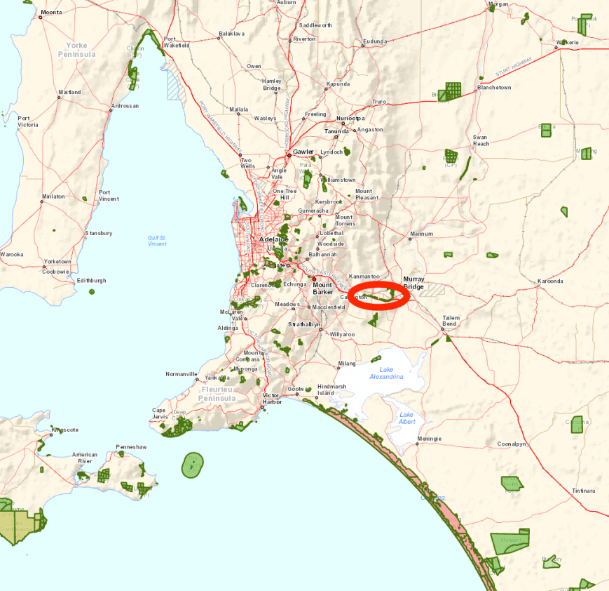
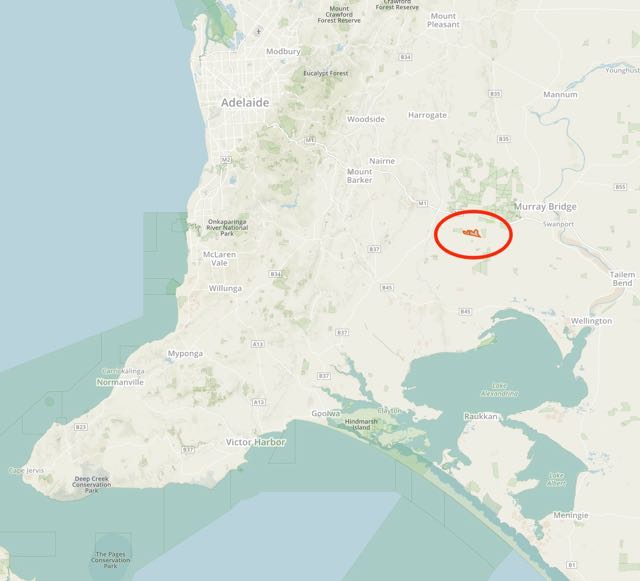
Above:- Map showing the location of the Monarto Woodlands Conservation Park, east of Adelaide. Map courtesy of Location SA Map Viewer.
The Monarto Woodlands Conservation Park was gazetted on the 22nd September 2016 and was previously set aside as Crown land. The park extends about 15 km along the South Eastern Freeway from near Callington to Murray Bridge. The park is 426 hectares in size, and provides important habitat for more than 60 bird species, five of which are of State conservation significance.
The scrub located within the park is a mixture of plant species from across Australia. This is due to the extensive planting in the area due to the proposed satellite city of Monarto back in the 1970’s. The then South Australian Premier, Don Dunstan had proposed that Monarto, or ‘New Murray Town’ would become the site of a satellite city of Adelaide. However this concept was eventually abandoned.
The park is in close proximity to the newly gazetted Kincina Conservation Park, and also the Monarto Conservation Park and the Ferries McDonald Conservation Park.
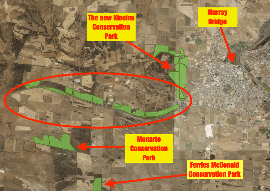
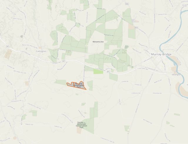
Above:- Map showing the location of the Monarto Woodlands Conservation Park, in relation to Murray Bridge and nearby parks. Map courtesy of Location SA Map Viewer.
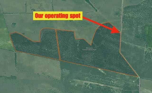
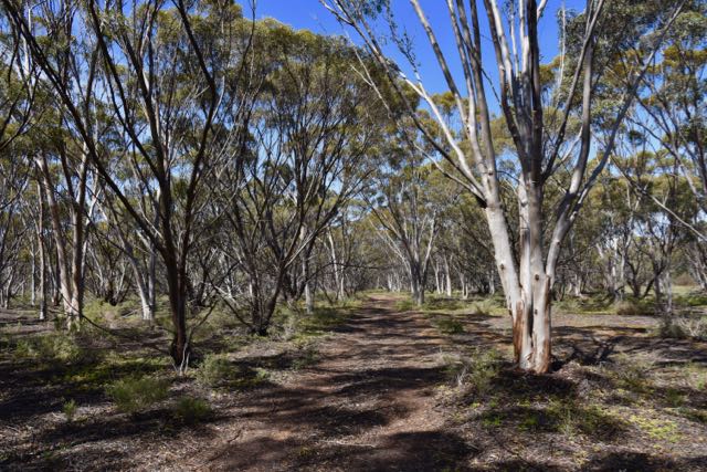
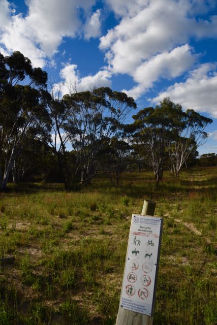
I took the Monarto exit from the South Eastern Freeway and then turned left onto Arbon Court. This is close to the industrial area of Monarto and borders a small part of the park which is located on the northern side of the Freeway. There is no vehicular access to the park here, but if you chose to do so, you could climb over the barbed wire fence into the park. I decided to check out some other sections of the park which are dotted along the South Eastern Freeway.
I then headed along White Road, which runs east-west on the northern side of the Freeway. The park borders the northern side of White Road. This part of the park has a barbed wire fence, which again is easily scaled, but I found an opening in the fence line with a track leading into the park.
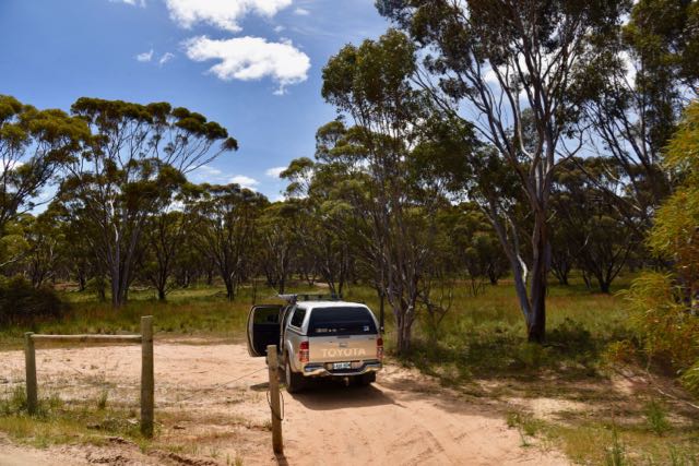
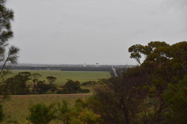
I followed this track for a few hundred metres and then found a clearing amongst the scrub and set up my station.
I was set up in the park by around 1.45 p.m. (0310 UTC), about 10 minutes after my posted time on parksnpeaks. I headed for 7.144 and started calling CQ, and it took around 5 minutes before I had my first taker. This was Ken VK3UH who is normally 5/9, but on this occasion was 5/7. I received a 4/5 from Ken. This was not a good sign. I hadn’t checked the propagation figures prior to leaving home, but I suspected that conditions were going to be rated as fair-poor as they have been for some time now.
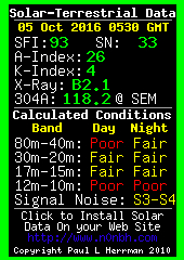
As it turned out the Solar Flux Index was 93, and the A Index was high at 26, with the K Index being 4. Not good!
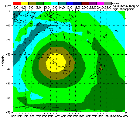
And the Hourly Area Prediction chart showed that 80 m was going to be the band for the local VK5 contacts and also into western Victoria.
My second contact was with Dennis VK2HHA in Albury who was also down in signal strength, followed by Marc VK3OHM in Melbourne who was 5/9 plus. But Marc’s great signal was to be one of only a very select few for this activation. I worked 14 stations on 40m from VK2, VK3, and VK7 with significant fading noted on most signals. It was really hard going with a lot of unanswered CQ calls.
I then lowered the squid pole and added the links and headed to 3.610 on 80m where I called CQ and this was immediately answered by Adrian VK5FANA on the Yorke Peninsula with a 5/7 sign, but with fading noted. This was followed by a call from Mark VK7FMPR in Tasmania. I was really surprised to hear from Mark at this time of the day and despite Mark’s signal not being strong, I was still receiving Mark well with a signal report of 5/1 (5/1 returned to me by Mark). And finally I worked John VK5BJE in the Adelaide Hills. John was a good 5/7 signal to Monarto Woodlands. Col VK5HCF called me a few times and although I was hearing Col quite well (5/7 with QSB), Col was struggling with noise at his end and we were unable to make a valid contact.
I then headed back to 7.144 on 40m and called CQ again and this was answered by Scott VK7NWT with a good strong 5/8 signal, followed by Wayne VK2PDW mobile in Wagga with a nice 5/7 signal. I worked a further 4 stations from VK2, VK3, and VK7. This included a Park to Park contact with Grant VK2GEL who was portable in Ku-Ring-Gai Chase National Park VKFF-0272. This was a pleasant surprise.
I then gave 20m a try, but sadly I was only able to log 2 stations. They being Robert VK2XXM and Ray VK4NH. A large amount of fading (QSB) was noted on the 20m band as well.
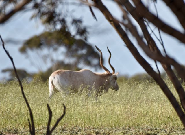
I took a break and went for a short walk through the park, trying out my luck with some bird photography. The park was alive with Red Wattlebirds, but they were quite hard to capture as they were regularly darting from tree to tree in the park.

Red Wattlebird

Willie Wagtail

Yellow plumed honeyeater
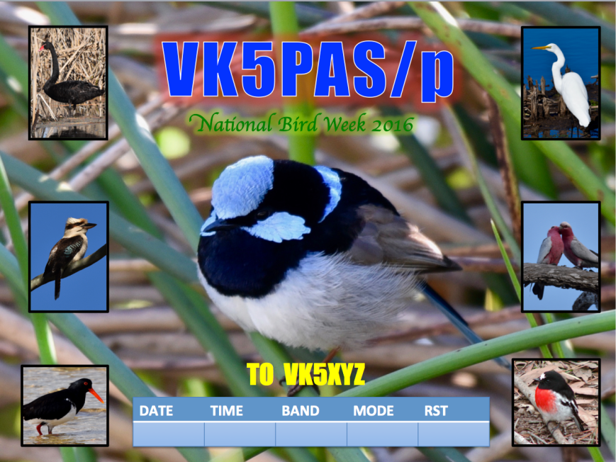
As this is National Bird Week, I have a special QSL card on offer for this activation at Monarto Woodlands Conservation Park. If you would like this special issue card, please send me your QSL card and I will return a card to you.
I returned to the radio and called CQ again on 7.144 and this was answered by Rick VK4RF/VK4HA, followed by Jim VK4OK. Jim’s signal was very very low and it took a number of attempts for me to copy Jim’s call sign and to have a valid signal report exchange (3/1 sent and 5/3 received). Alan VK3FALN then called but unfortunately Alan’s audio was breaking up quite a bit. Alan gave me a 5/7 signal report, but sadly we were unable to complete the contact as Alan completely faded away just as he was about to give me a signal report. The band had changed dramatically, very quickly. I then worked Andrew VK7DW and John VK4TJ.
John and I were curious to see whether our signals may be stronger on 20m, so after a quick lowering of the squid pole, and removal of the links in the dipole, I headed to 14.310. John was one S point stronger on 20m (5/7), but very deep fading (QSB) was present and this made it quite hard at times. Two more Queensland stations were logged on 20m. The first being Steve VK4KUS at Hervey Bay with a nice 5/8 signal, and then Bill VK4FW who was 5/9.
It was at this time that Nigel VK5NIG gave me a call to advise that he was at Meadows, and was keen to call in to my home QTH for a coffee. I informed Nigel I was up at Monarto in a park, and he agreed that he would come up for a drive to say g’day. I then took another break from the radio and went for a further walk in the park, waiting for Nigel to arrive. It was a good opportunity to explore the park.
Just before Nigel arrived I called CQ again in 7.144 and Peter VK3PF gave me a shout, using one of his other call signs, VK3KAI, to help me out towards my 44 required QSOs to qualify the park for WWFF. Thanks Peter. Tex VK1TX then called in with a beautiful 5/9 signal, followed by Ian VK1DI, and then Bill VK4FW. But that was the limit of callers. It did however offer an opportunity for me to have a chin wag with Nigel.
About 30 minutes later I lowered the squid pole and removed the links and then headed to 14.310 on 20m. There were German speaking stations on 14.307 so I went little higher to 14.311 and started calling CQ. This was answered by Hans VK6XN who has just commenced as a park hunter. Next up was my first DX, Luciano I5FLN in Italy with a good 5/9 signal, followed by Dario IT9ZZO and then Jaroslav OK2TS in the Czech Republic. I went on to work a further 15 stations from Italy, Slovenia, Germany, France, Hungary, Russia, and the Czech Republic.
So after a slow start I had a total of 60 contacts in the log and a unique park for me to add to my activator tally for both the WWFF program and the VK5 Parks Award.
The following stations were worked on 40m SSB:-
- VK3UH
- VK2HHA
- VK3OHM
- VK3GGG
- VK3PMG
- VK3MCK
- VK3PF
- VK3FCMC
- VK3VBI
- VK7LTD
- VK2IO
- VK4AAC/3
- VK7FRJG
- VK3PR
- VK7NWT
- VK2PDW/m
- VK2XXM
- VK2GEL/p (Ku-Ring-Gai Chase National Park VKFF-0272)
- VK7EE
- VK3DQ
- VK4RF
- VK4HA
- VK4OK
- VK7DW
- VK4TJ
- VK3KAI
- VK1TX
- VK2KJJ
- VK1DI
- VK4FW
The following stations were worked on 80m SSB:-
- VK5FANA
- VK7FMPR
- VK5BJE
The following stations were worked on 20m SSB:-
- VK2XXM
- VK4NH
- VK4TJ
- AC8WN/VK4
- VE6XT/VK4
- VK4KUS
- VK4FW
- VK6XN
- I5FLN
- IT9ZZO
- OK2TS
- IK2VUC
- IK1GPG
- S52KM
- DK0EE
- F1BLL
- HA6OB
- IZ1UKF
- IK2ZJN
- IW2NXI
- IK8FIQ
- RA3QK
- IZ5JMZ
- IV3DSF
- OK7WA
- DJ8QP
Thankyou to the following for spotting me on parksnpeaks and the DX Cluster:
- Marc VK3OHM
- Mick VK3GGG
- Ken VK3UH
- Peter VK3PF
- Adrian VK5FANA
- Robert VK2XXM
- Ray VK4NH
- Bill VK4FW
- Luciano I5FLN
- Hans VK6XN
- Lou IV3DSG
- Renzo IK2ZJN
- Giovanni IZ5JMZ
Spotting really does make a difference, and even more so when conditions are poor as they were today. So thanks again to everyone who took the time to spot me.
After packing up I headed east along White Road. The park finishes a few hundred metres up the road, with the Ingham chicken farm very noticeable. The park then recommences and concludes a few km up the road close to Murray Bridge.
I then took the Old Princes Highway back to Callington. This took me passed the southern boundary of the Monarto Zoological Open Plains Zoo. This is the largest open plains zoo in the world.
I then drove in to Monarto, which nowadays consists of a church, a hall and farm houses. Monarto South is located about 3 km to the south of Monarto and this comprises a few farmhouses, the Adelaide-Melbourne rail line, and silos.
Prior to heading to the park I had read on the internet of the Monarto Woodlands and Browns Road at Monarto, and that this appeared to be a popular spot for birdwatchers. However that section of scrub did not show up on Location SA Map Viewer as being part of the park. I headed to the corner of Old Princes Highway, Browns Road, Highland Road, and Thomas Crescent. There are two large portions of scrub situated at this corner. The first being bordered by Browns Road and Highland Road to the north of Old Princes Hwy, and the second section of scrub on the eastern side of Thomas Crescent, south of the Old Princes Hwy. They both have the same ‘Monarto Woodlands’ sign as the scrub on White Road, but for whatever reason are not showing up as part of the park. I will make some enquiries with the Department Environment Water & Natural Resources to find out why.
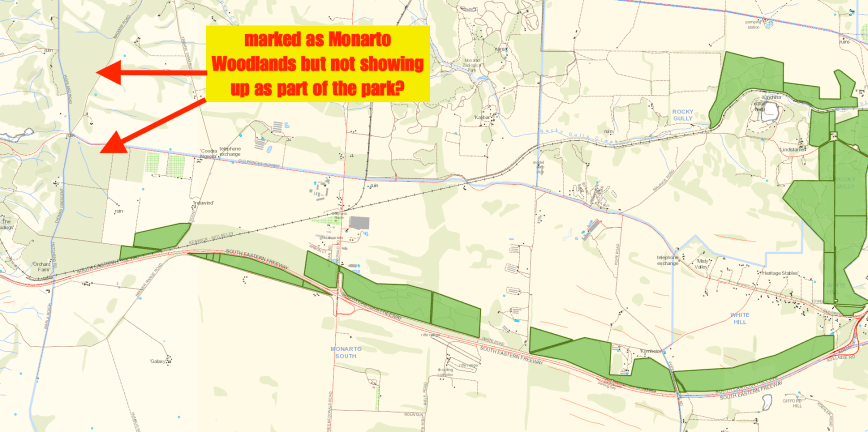
Above:- Map showing the Monarto Woodlands CP, and the 2 sections of scrub that appear not to be part of the park. Image courtesy of Location SA Map Viewer.
References.
Government of South Australia, 2016, <http://www.premier.sa.gov.au/index.php/ian-hunters-news-releases/1188-two-new-conservation-parks-for-sa>, viewed 19th October 2016